Russian Mountaineering Federation Russian Mountaineering Federation
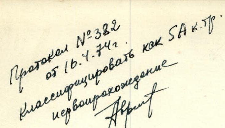
Protocol No. 382 dated April 5, 1974 Classify as Category 5A difficulty First Ascent
2.7.104 115
SKATIKOM
Tbilisi 1973
| Date | Section passed | Average steepness | Height gain (in m) | Characteristics and conditions of relief | Technical difficulty | Insurance method | Weather conditions | Departure time | Overnight stops | Climbing hours | Rock pitons driven | Ice pitons | Bolt pitons | Overnight conditions / Daily ration weight |
|---|---|---|---|---|---|---|---|---|---|---|---|---|---|---|
| August 7, 1973 | Section R1–R2 | 35–40° | 60–90 | Unpronounced counterfort | Medium difficulty | Ice axe and ledges | Good | 5:00 | – | 1:40 | – | – | – | |
| Section R2–R3 | 45–50° | 80–90 | Rocks | Medium difficulty | Ledges | Good | 6:50 | – | 1:50 | – | – | – | ||
| Section R3–R4 | 35–45° | 80–90 | Traverse of icy couloir, "ram's foreheads" | Difficult | Pitons | Good | 7:50 | – | 1:10 | 8 | 4 | – | Constructing a good site | |
| Section R4–R5 | 75–90° | 40 | Wet wall | Very difficult | Pitons | Good | 9:20 | – | 3:00 | 10 | – | – | ||
| Section R5–R6 | 55–60° | 100–110 | Unpronounced ridge | Difficult | Pitons, ledges | Good | 12:30 | 15:30 | 3:00 | 9 | – | – | ||
| August 8 | Section R6–R7 | 75–90° | 40–45 | Wall | Very difficult | Pitons | Good | 8:00 | – | 3:30 | 10 | 4 | Normal / 650 grams | |
| Section R7–R8 | 45–50° | 50–70 | Semi-traverse of rock | Difficult | Pitons, ledges | Normal | 11:40 | – | 1:30 | 5 | – | |||
| Section R8–R9 | 45–50° | 100–120 | Rocks, slabs | Difficult | Pitons | Normal | 13:20 | 16:30 | 2:50 | 9 | – | |||
| August 9 | Section R9–R10 | 40–50° | 120–140 | Pre-summit ridge, icy couloir | Medium difficulty | Pitons, ledges | Normal | 7:00 | 12:00 (summit) | 4:00 | 3 | 3 | – | Normal / 650 grams |
Descent from the summit via the South Ridge, Category 3A difficulty.
| DATE | DESIGNATION | AVERAGE STEEPNESS | RELIEF CHARACTER | DIFFICULTY | LENGTH IN M. | CONDITIONS | WEATHER CONDITIONS | ROCK PITONS | ICE PITONS | BOLT PITONS |
|---|---|---|---|---|---|---|---|---|---|---|
| July 6, 1980 | R0–R1 | 45° | Snow slope | 1 | 50 | Deep, loose snow | Good | – | – | – |
| R1–R2 | 60° | Wall | 4 | 90 | Destroyed rocks with snow and ice; few cracks suitable for pitons | Good | 12 | – | – | |
| R2–R3 | 85° | Vertical chimney with a plug | 1 | 50 | Wet rocks, ice accretion | Good | 1, 2 | – | – | |
| R3–R4 | 65° | Wall | 4 | 65 | Steep destroyed rocks with sections of monolithic slabs | Good | 6 | 1 | – | |
| R4–R5 | 90° | Slab | 5 | 10 | Steep rocks with few holds, loose rocks at the top | Good | 1 | 1 | – | |
| R5–R6 | 70° | Ridge | 5 | 90 | Steep destroyed rocks alternating with monolithic sections, few cracks for pitons | Good | 14 | 1 | – | |
| R6–R7 | 90° | Inner | 5 | 20 | Steep dry rocks, loose rocks at the top | Good | 3 | 1 | – | |
| R7–R8 | 45° | Slope | 3 | 200–250 | Scree slopes, snow sections, destroyed rocks, monolithic slabs | Good | 5 | – | – |
July 6, 1980: Departure on the route — 7:30. Return from the route — 17:30 (summit ascent). Climbing hours — 10.
Team composition and experience:
Main team:
- KARTVELISHVILI G. I. — Master of Sports of International Class — Team leader
- IBERI E. D. — 1st category — Deputy team leader
- KIKODZE Z. K. — 1st category — Team member
- ERKOMAISHVILI O. N. — Master of Sports of International Class — Team coach
Observers:
- SIMONISHVILI D. M. — 2nd category — Team leader
- SAKVARELI A T. G. — 2nd category — Medical nurse
- SIMONISHVILI K. M. — 3rd category
- MAISURADZE G. D. — 3rd category
The team, with this composition, has completed many high-category ascents in different years, in addition to training climbs.
The team leader and coach had many years of experience in joint ascents on routes of the highest categories, including several first ascents.
The young team members also had experience in high-category ascents.
Before departing on the route, the team was fully prepared for such an ascent.
August 4, 1973. From Shovi resort, we ascend via a trail to the first camp located at an altitude of 2600 m above sea level. Then, we proceed along the right (orographic) moraine of the Tbiliza glacier. After 1.5 hours of walking, we reach the glacier. The glacier is heavily crevassed; we continue for another 1.5 hours along the glacier and approach the beginning of the counterfort leading to the Karaugom plateau. The counterfort is difficult and prone to rockfall; we move with careful belaying. After two rope lengths, the rocks become gentler, and the movement becomes easier. After 3 hours of climbing, we reach the camping site on the counterfort at an altitude of 3700 m. We stop for the night and plan to undertake a training ascent to the "Burеvestnik" peak — Category 3A difficulty.
August 5, 1973. We depart early in the morning, descending 40 m to the firn field of the middle tongue of the Tbiliza glacier. After 30 minutes, we approach a steep snowy-icy couloir leading to the Karaugom plateau.
The couloir is 4 rope lengths long. We emerge onto the Karaugom plateau, leave our backpacks, and ascend to the "Burеvestnik" peak via the NW ridge.
- Ascent took 3 hours
- Descent took 1.5 hours
After the ascent, we set up a camp at the "Bivouac overnight stays".
August 6, 1973. We observe and study the SW wall of the SKATIKOM peak. We mark the approximate overnight locations (see photo No. 1).
Ascent
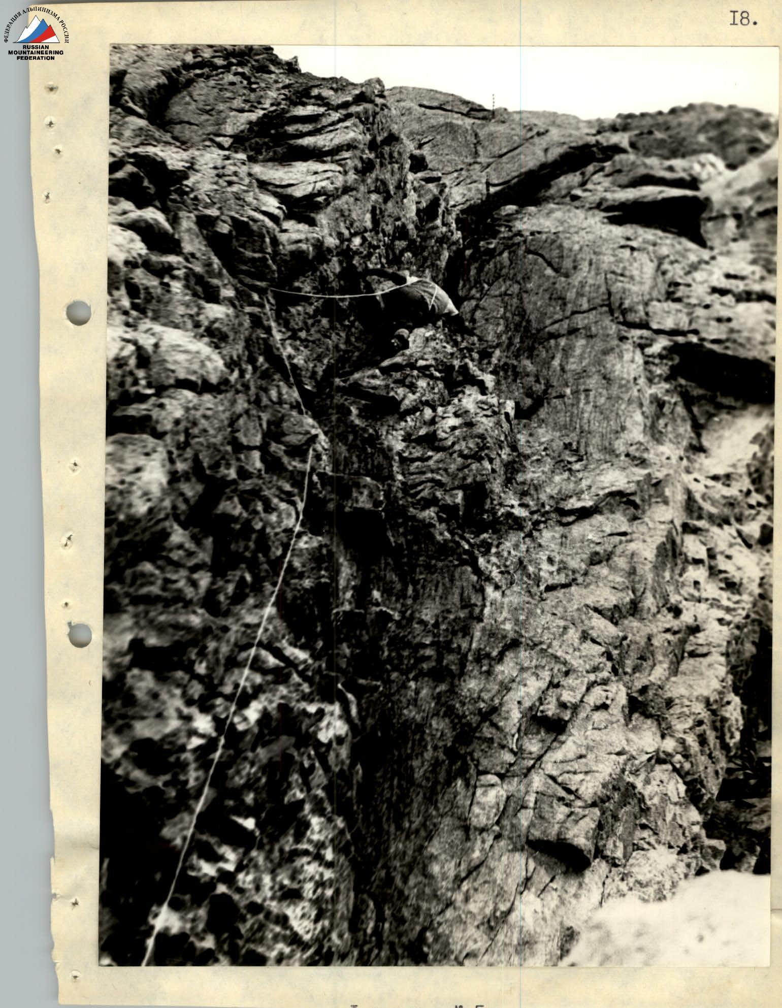
August 7, 1973. From the "Bivouac overnight stays" to the foot of the SW wall of the SKATIKOM peak is a 40-minute walk. The route begins with an unpronounced counterfort with a triangle (photo No. 2). We ascend onto the counterfort from its right side via snow. In the upper part of the triangle, there is ice in some places (2–2.5 rope lengths) (section R1–R2). At the end of the triangle, we set the first control cairn. From the control cairn, we ascend directly upwards — 3 rope lengths along the ridge, rocks of medium difficulty, belaying via ledges (photo No. 3) (section R2–R3). Then, we traverse left across a steep snowy-rocky couloir (rockfall, cautious movement). The couloir is icy in some places; we cut steps, rocks are frozen, "ram's foreheads" are encountered, 3 rope lengths, piton belaying (section R3–R4) (photo No. 4). We approach the first wet wall: the wall is a 40-meter-wide internal angle with a steepness of 75°, and in some places, 90°; a waterfall flows down the wall. Piton belaying; we drive 10 rock pitons; backpacks are pulled up. Below and above the wall are the II and III control cairns (photo No. 5), (section R4–R5).
After the wet wall, we ascend directly upwards for 4 rope lengths; rocks are difficult but have many good holds; belaying via pitons and ledges:
- 9 rock pitons
- section R5–R6
We approach the second wall. It's already 16:00. We search for a suitable overnight location, find one, and set up a tent. By 19:00, everyone is resting.
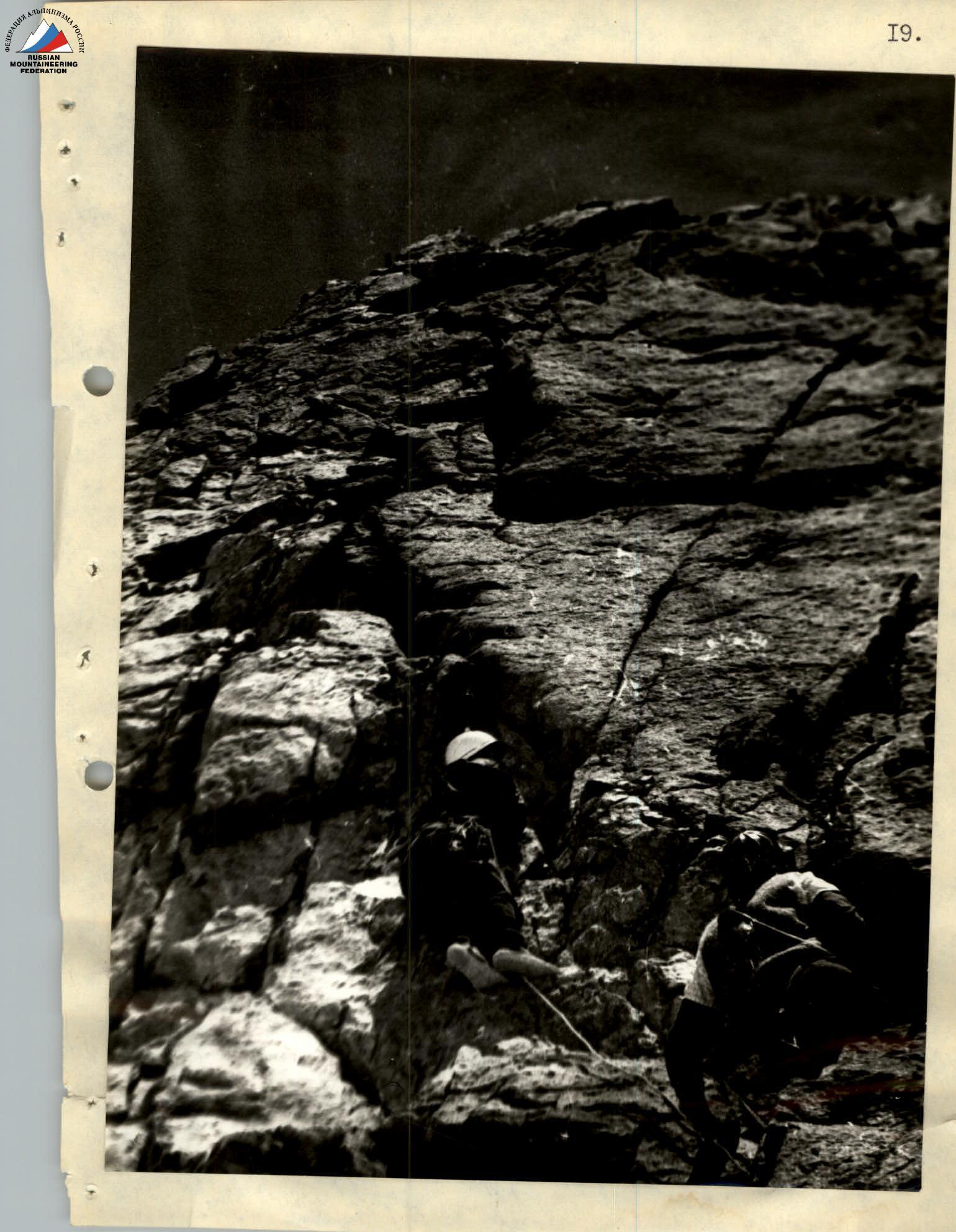
August 8, 1973. We depart at 8:00. After half a rope length, we approach the second — the only inclined, wide 15–20 cm crack; the wall overhangs at the top. The first climber ascends in climbing shoes without any extra weight, and we have to drive in bolt and petal pitons. After 30 m, the rock overhangs; we hang ladders, ascend onto a 3-meter inclined (30–35°) narrow chimney, which is bypassed by crawling; piton belaying; we drive 4 bolt pitons and 10 rock pitons (section R6–R7); backpacks are pulled up. Below the wall, at the overnight site, and above the wall, we set the IV and V control cairns (photo No. 6).
After the wall, we ascend to the right for one rope length across difficult rocks; we emerge onto the ridge; piton belaying. Along the ridge, we ascend for 1.5–2 rope lengths across rocks of medium difficulty. Belying via ledges and pitons (4 pitons). We approach a large rock cornice; below the cornice are good overnight sites, but it's still early, so we continue. To the right, we emerge onto the ridge (section R7–R8).
We ascend directly upwards; rocks are difficult, with slabs in some places; piton belaying (9 rock pitons). 4–5 rope lengths. By 16:30, we reach below the pre-summit ridge and make an overnight stop. By 20:00, we have tea and rest (section R8–R9).
August 9, 1973. We depart in the morning at 7:00. After half a rope length directly upwards, we approach a gendarme, which is bypassed via rocks on the right, and we emerge into an icy couloir (photo No. 7). The couloir is steep (45–50°), 35 m long. We ascend directly upwards through the couloir, cut steps, and use ice piton belaying (3 pitons). After 5 rope lengths across rocks of medium difficulty, we reach the summit (at 11:00) (section R9–R10).
Descent from the summit via the South Ridge, Category 3A difficulty. By 16:00, we descend to the Karaugom plateau. We return to the camp at "Bivouac overnight stays".
Conclusions
The above-described route has several positive qualities that are in favor of climbers:
- The wall is monolithic and logical;
- The route offers many convenient and safe overnight sites;
- Complex and relatively simple sections alternate, allowing for recovery.
The above-described route can be compared to such well-known routes as:
- Peak Shchurovskogo via the NW wall (via "Surk");
- North ridge to the peak Tsal gmil;
- South peak of Ushba via the SE wall (via "Gabrielle").
Based on the above, the described route merits a classification as Category 5A difficulty.
Team leader Master of Sports of International Class G. I. KARTVELISHVILI