Ascent Passport
- Caucasus. Saudor ridge. Khuppara valley. Section number in Classification 2.7.
- Peak 3939 m (Special Operations Forces) via North Ridge. Peak coordinates: 42°50′10.96″ N; 43°45′5.78″ E.
- Proposed category: 1B, first ascent.
- Route type: rock.
- Route elevation gain: 200 m.
Total route length: about 300 m. Length of sections with 2–3 complexity category: 50 m. Steepness of key sections: up to 60°. Average route steepness: 35°.
- No pitons left on the route.
- Time taken: 6 hours; days: 1.
- Leader: Egorin S. V. — Master of Sports
Team members:
- Bolkovoy E. V. — Master of Sports
- Maksimov D. S. — 1st sports category
- Krutikov D. A. — 2nd sports category
- Coach: Egorin S. V. — Master of Sports
- Approach to the route, summit, descent: August 19, 2016.
- Organization: Besengi Alpine Club.
- Leader's contact information for report inquiries:
Phone: +7 928 490-31-28; email: e.s.128@mail.ru
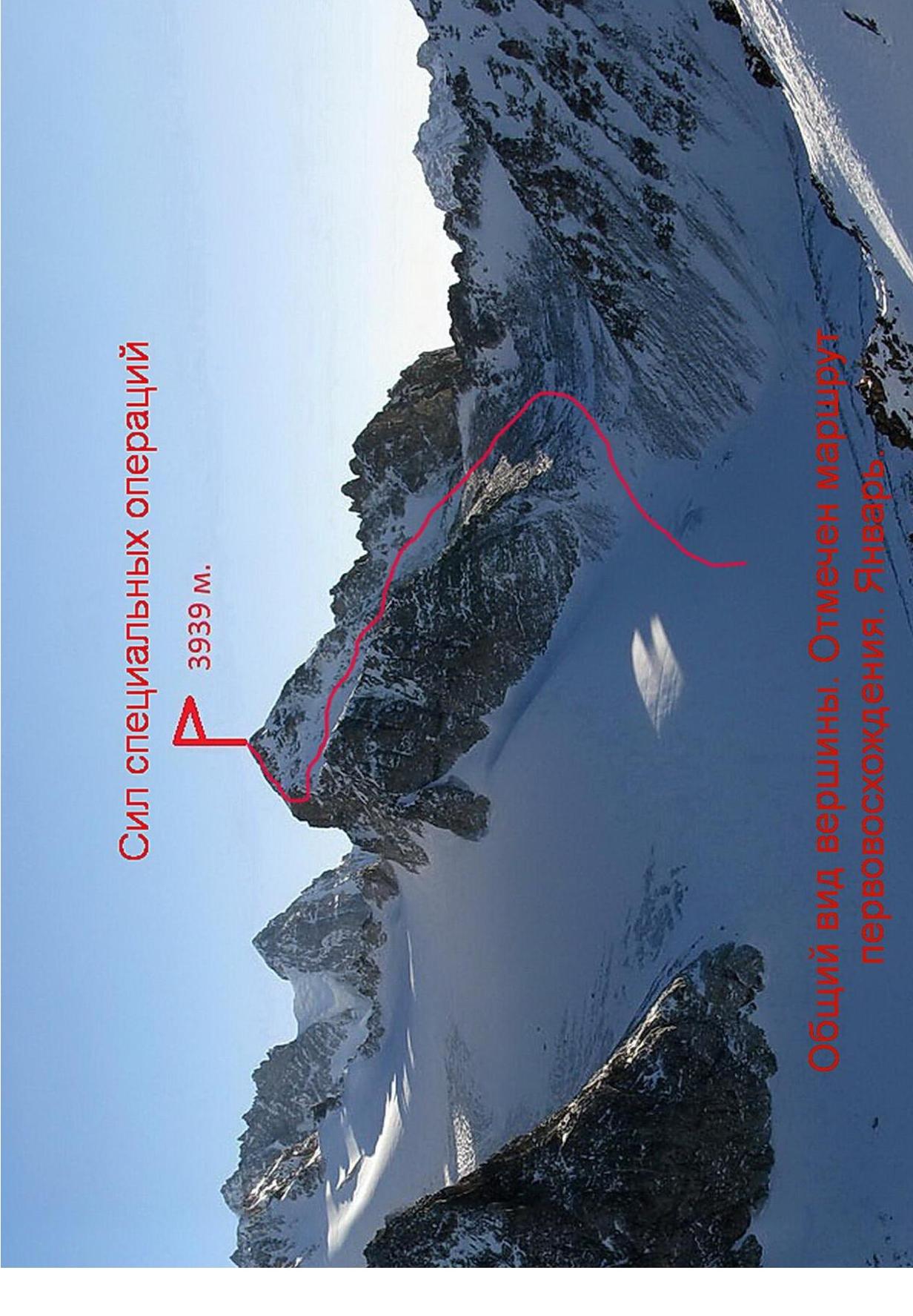
 Peak Special Operations Forces 3939 m. General view of the peak. The first ascent route is marked. January.
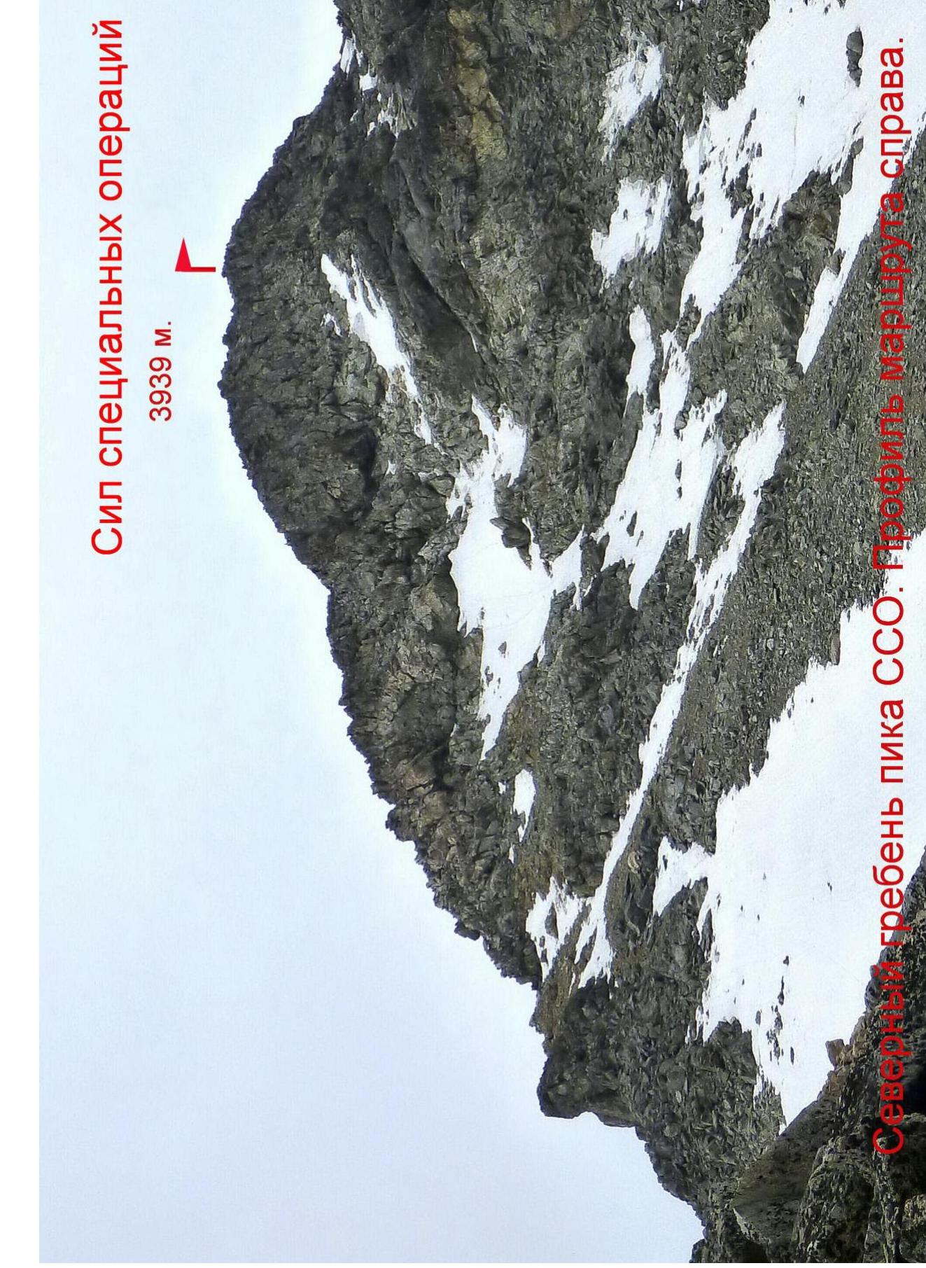
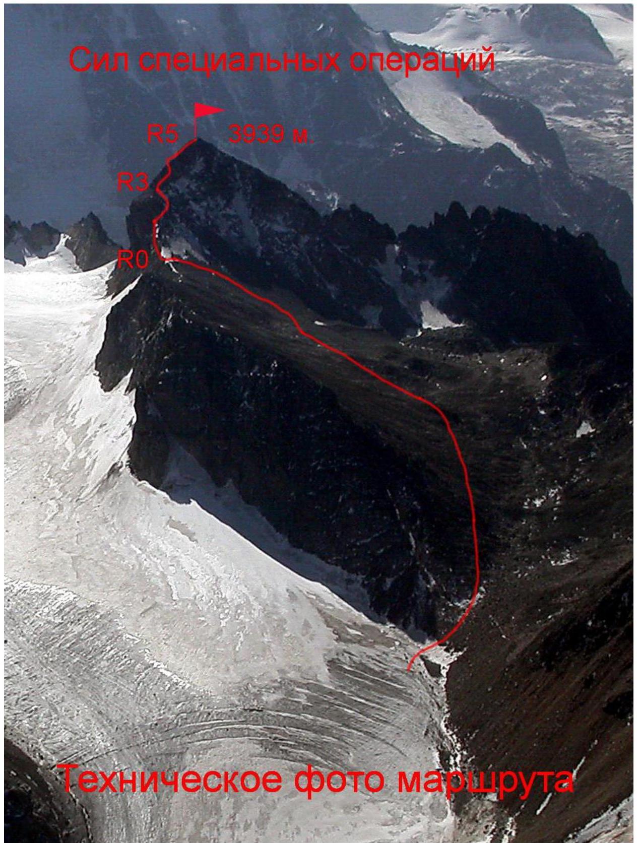
 Peak Special Operations Forces 3939 m. North ridge of SSO peak. Route profile on the right.
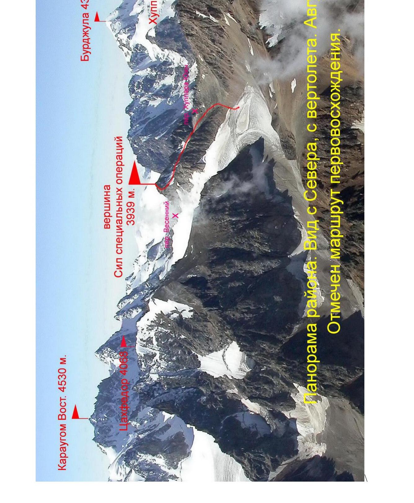
 Karaugom East 4530 m. Burdzhula 4364 m. Tsakhfedor 4068 m. Peak Special Operations Forces 3939 m. Vesenniy Pass. Khuppara 3872 m. Panorama of the area. View from the north, from a helicopter. August. The first ascent route is marked.
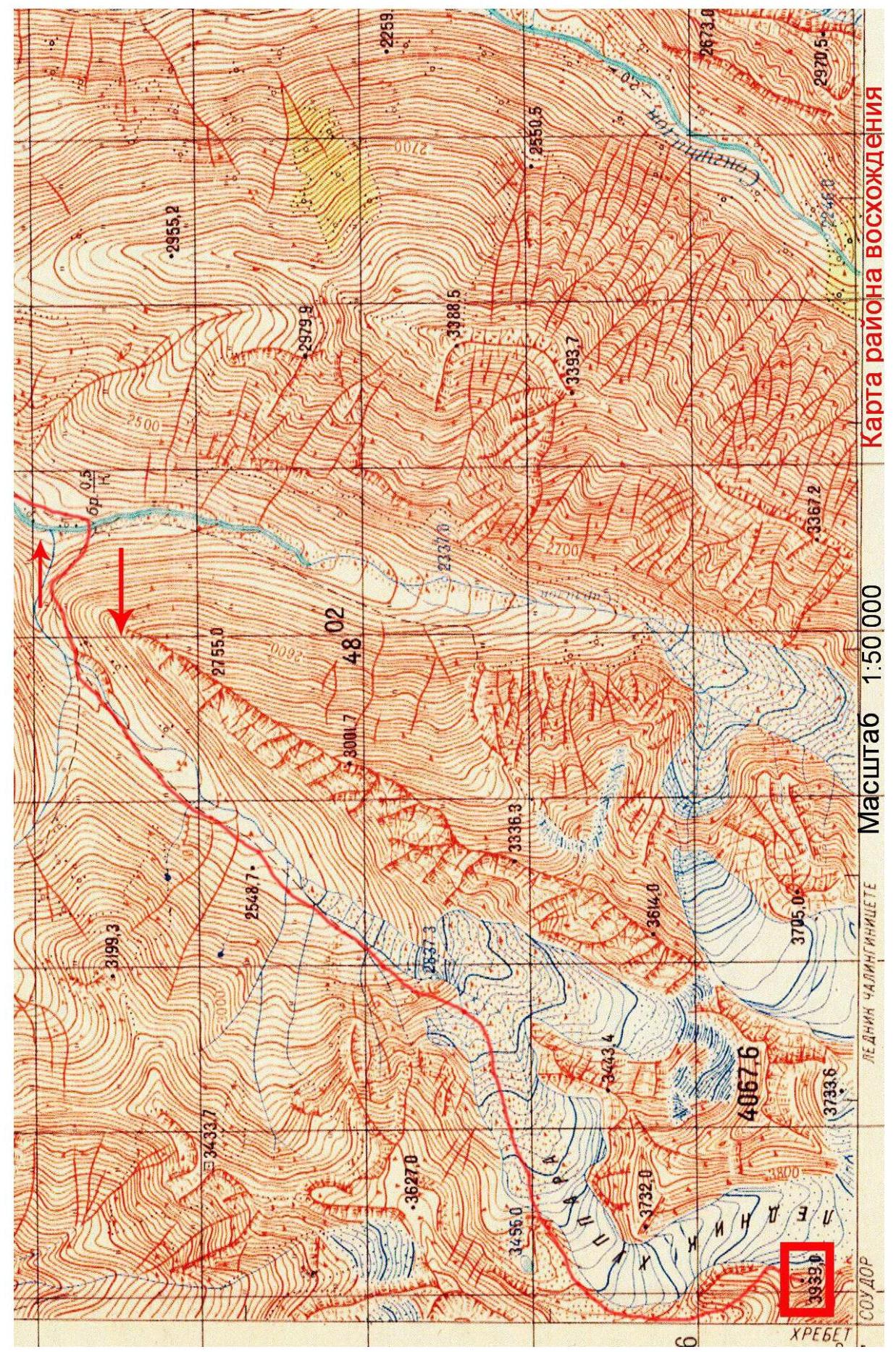
 Scale 1:50 000. Map of the ascent area.
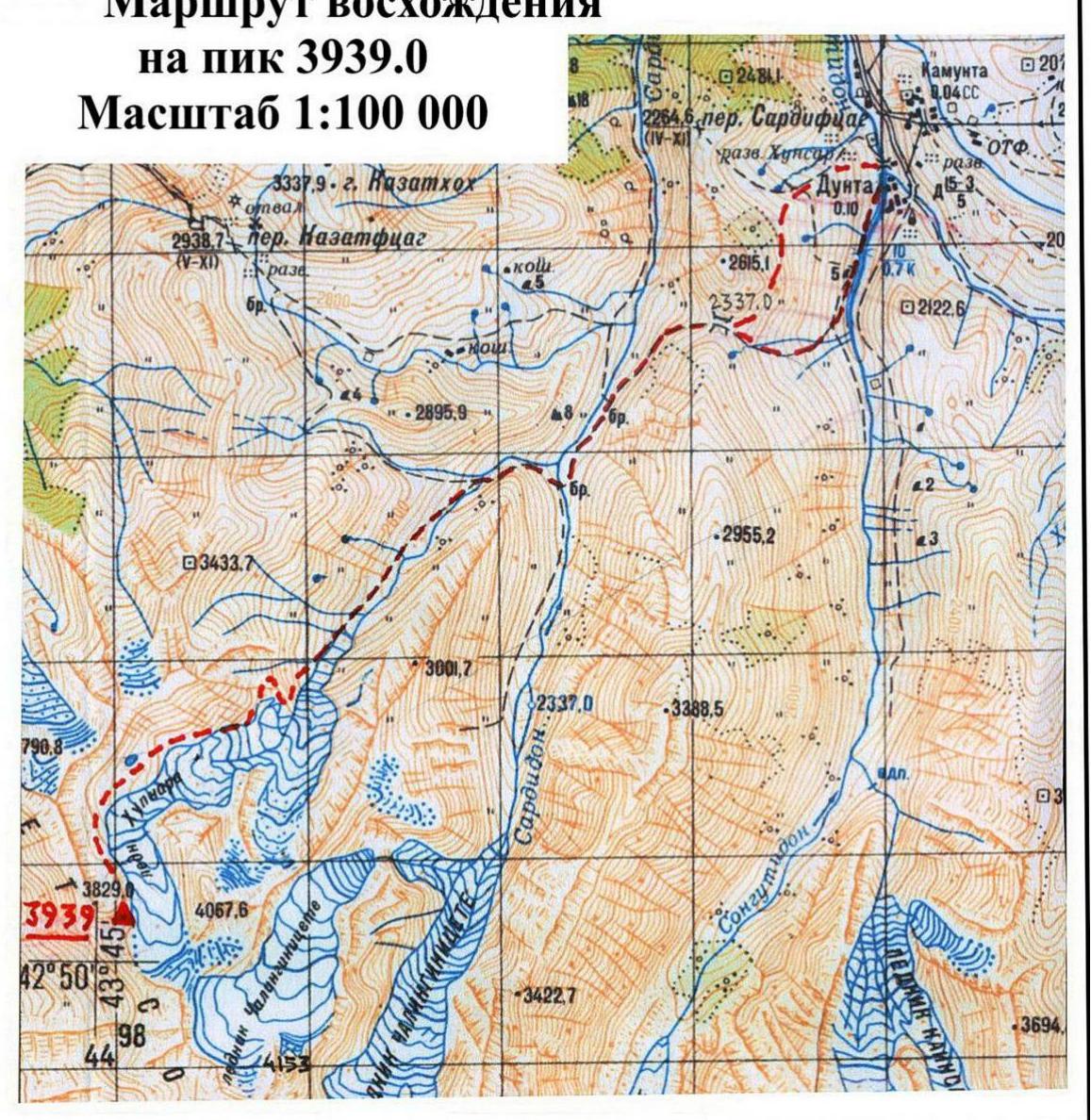
 Ascent route to peak 3939 m. Scale 1:100 000.
Approach route from Dunta village (1780 m). Interval Dunta village — Lake.
Overview of the Ascent Area
Peak 3939 m is located in the center of the Saudor ridge. The Saudor ridge (translated from the Digor dialect of the Ossetian language as "black stones") is situated in Eastern Digoria — a mountainous region of the Republic of North Ossetia — Alania. The Saudor ridge is approximately 10 km long. In fact, this ridge is a spur of the Bokovoy ridge, located to the south. Its highest point is the peak Saudor 4209 m, and from it, the Saudor ridge extends northwest.
The Saudor ridge is composed of ancient rocks: light gray Paleozoic granites and dense, highly metamorphosed Lower Mesozoic clay shales. There are several glaciers that continue to shrink. The largest of them are Chilingini, Kadurkhoshkhin, Khuppara, and Tsadoti.
On topographic maps, the Saudor ridge is incorrectly labeled as "Soudor" (with an "o"), but this is an incorrect spelling. The average height of the peaks in the ridge is around 4000 m. Surprisingly, the Saudor ridge is poorly explored by climbers, likely due to its remoteness from alpine camps in the Tsey valley and Western Digoria. In contrast, tourists have explored the ridge well, with over 20 passes traversed and described. By 2017, there was only one route to the peaks of the Saudor ridge listed in the Climber's Route Classifier — the route to Saudor from the Gular glacier, category 2B.
The Saudor ridge is situated between the Karaugomdon river basin to the west and the Sardidon river basin to the east.
The Khuppara river is a left tributary of the Sardidon river, and in its upper reaches, there is a glacier of the same name, which has now divided into two parts. In the mid-20th century, geologists worked in the Khuppara valley, and traces of their activities can still be seen:
- exploratory adits;
- remains of trails, etc.
From the upper part of the Khuppara valley, one can descend to the Karaugom glacier via the Khuppara South pass (category 1B) or the Vesenniy pass (category 2B). Peak 3939 m is located between these passes.
Description of the Approach to the Route
To get to the valley of the Sardidon river from Vladikavkaz, take a bus to Dunta village — about 120 km. The canyon in the lower part of the valley prevents access from below, so from Dunta village, one must cross the Kazatvceg pass (known to tourists as the Dunta pass), which is 2337 m high.
To reach the trail to the pass:
- enter Dunta village;
- cross the Dargom river by bridge;
- descend to the right to the bridge over the Songutidon river.
After crossing the bridge, take the old trail and ascend leftward to the saddle of the Kazatvceg pass in 2–3 hours. The elevation gain from Dunta village is about 600 m.
From the pass, descend leftward down a good trail. After 30 minutes, you will reach a cattle enclosure (kosh), where livestock are grazed in the summer.
Locals call the Sardidon valley "Skatikom" — "cattle pen" (for livestock), due to its seclusion. The valley is used for summer grazing, and the animals roam freely.
Pass the kosh and ascend to the bank of the Sardidon river. On the right, you will see a stream flowing into the main river — the Khuppara river.
Proceed upstream about 700 m to the point where the Sardidon river divides into braids and ford the river.
Caution! In the first half of the summer, especially in the evening or after rain, the flow can be very strong! It takes about 1.5 hours from the pass to the ford.
Continue along the slope above the river and follow the old geological trail into the Khuppara valley. The trail mostly traverses the left slope of the valley. In some places, the trail is overgrown and difficult to see.
1.5 hours from the ford, you will reach a steep conglomerate slope and cross the Khuppara river to the other bank. Follow the river, passing the "ram's foreheads" visible ahead. After crossing a major tributary on the right, continue for another half kilometer and cross the main river again.
Here, among the scree, you will find an old pack trail. The trail is partially well-preserved, and its serpentines are visible on Google Earth satellite images.
Follow the trail, passing left of a waterfall, and ascend to the "ram's foreheads." Move rightward and continue up the scree and moraine slopes to reach sandy campsites at an altitude of 3200 m. To your left are the northern walls of Tsakhfedor peak, and ahead, you will see Khuppara peak. Coordinates of the campsites: 42°51′10.10″ N, 43°45′52.95″ E. It takes 5–6 hours of walking from the Sardidon ford.
Route Breakdown by Sections
| Section | Length, m | Steepness, degrees | Terrain type | Category | Number of pitons |
|---|---|---|---|---|---|
| R0–R1 | 50 | 30 | snow | 1–2 | - |
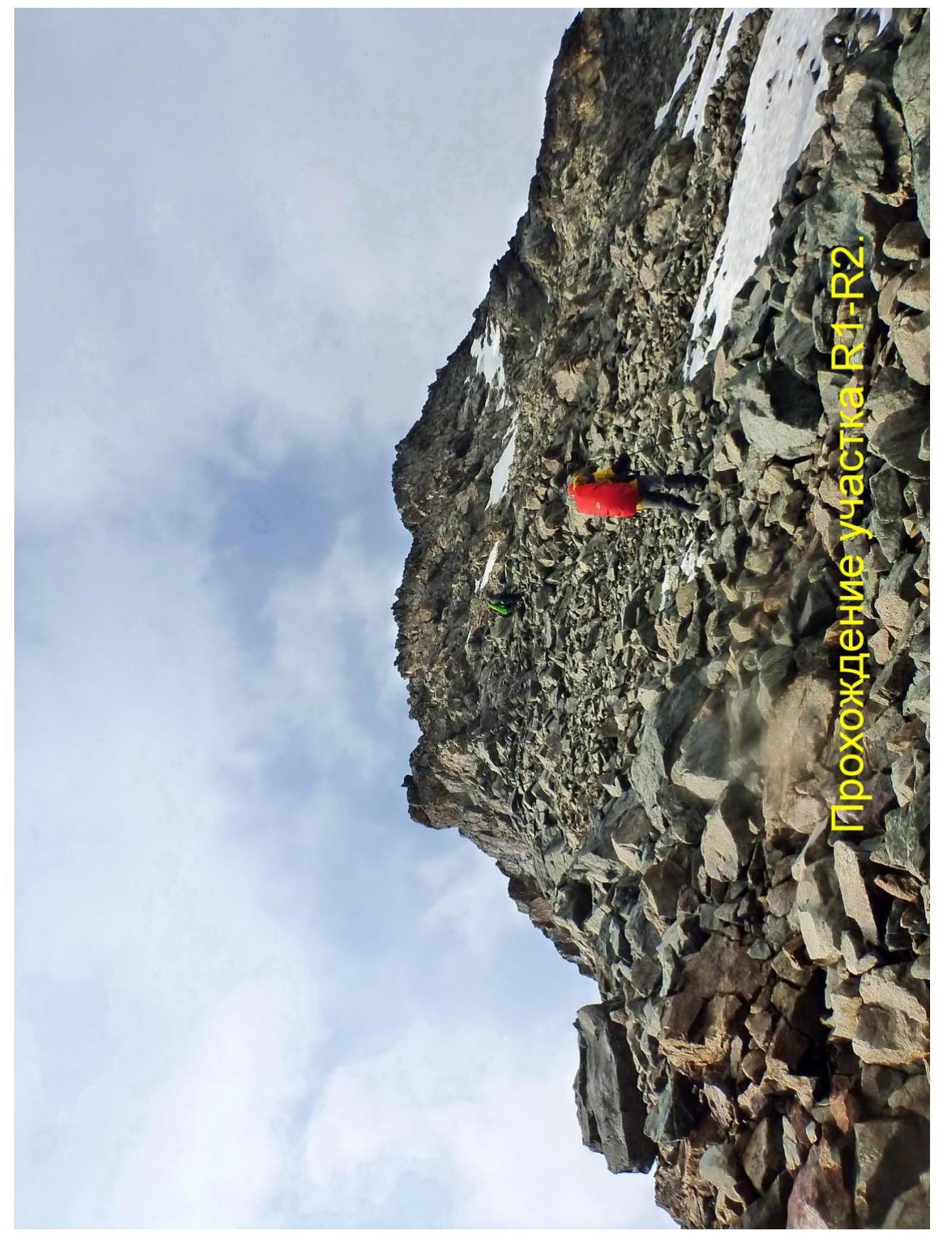
| R1–R2 | 100 | 30–35 | scree | 1 | - |
| R2–R3 | 50 | 30–40 | snow, scree | 1–2 | - |
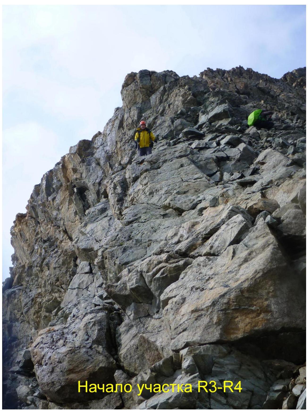
| R3–R4 | 50 | 30–60 | rock | 2–3 | - |
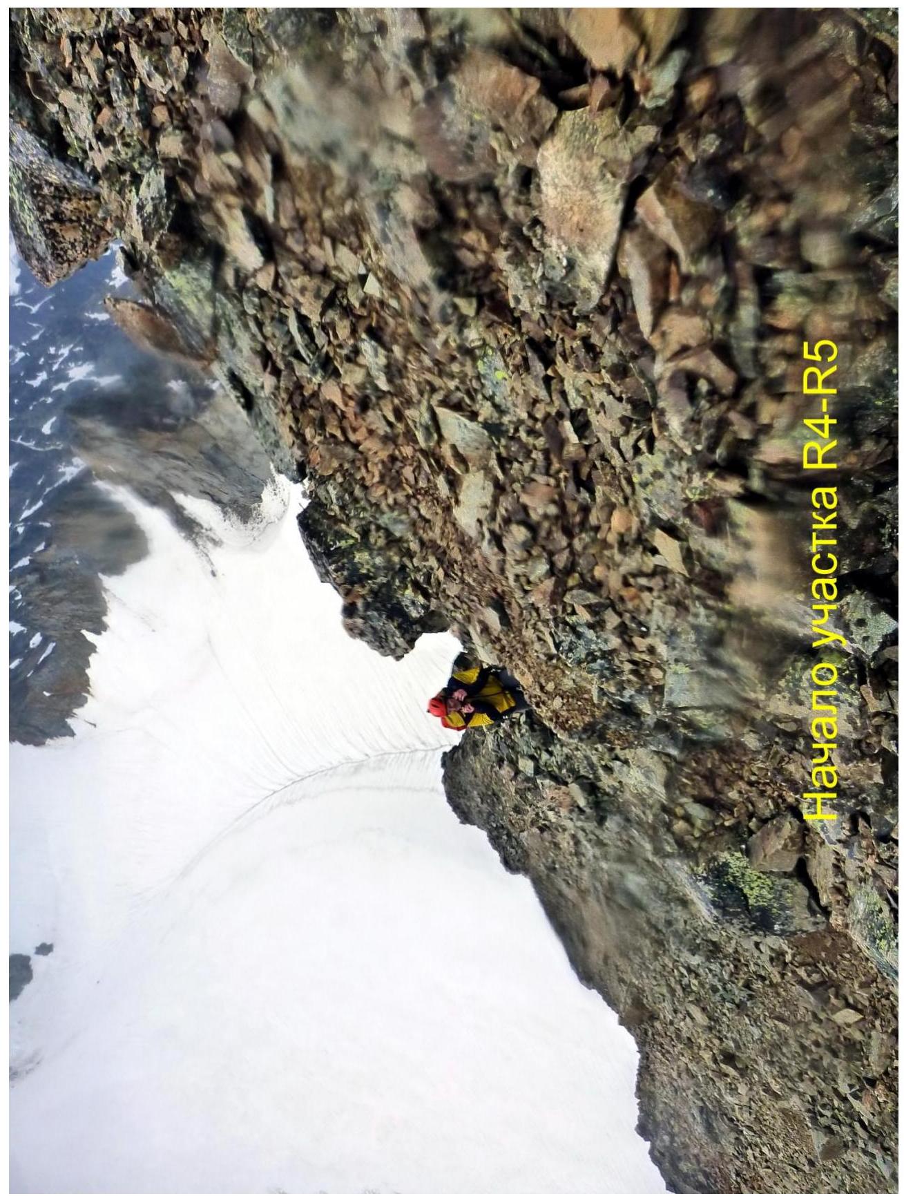
| R4–R5 | 60 | 30–50 | rock | 1–3 | - |
Route Description
From the campsites, continue up the scree and moraine slopes toward the visible Western Khuppara glacier. After about 30 minutes, you will reach the glacier and traverse its right (true left) part. The glacier is gentle and crevasse-free. Ahead, you will see the entrance to a side cirque under the Khuppara South pass. Coordinates of the lower part of the scree slope leading to this cirque: 42°50′36.28″ N; 43°44′58.95″ E.
Caution! The slope consists of loose, large-block scree! Continue into the side cirque of the Khuppara South pass. Traverse ancient moraines and large-block scree, and when you reach the middle of the cirque, turn left. The pyramid of peak 3939 m will be above you. Continue up snow and scree slopes (category 1 complexity) and reach a saddle in the North ridge of peak 3939 m.
R0–R1: On the saddle, turn right and follow a broad snow ridge (category 1–2, 30°) for about 50 m.
R1–R2: Traverse a broad scree slope-ridge (category 1, 30–35°) for another 100 m.
R2–R3: Bypass the rock step on the ridge to the right, on snow, and ascend leftward on scree to the main section of the route — the summit ridge. This section is 50 m long, category 1–2, 30–40°.
R3–R4: Bypass the next rock step on the ridge to the right, on rock (category 2–3, up to 60°), for 20 m to reach the ridge line. Then continue along the ridge with short walls (category 2–3) for another 30 m.
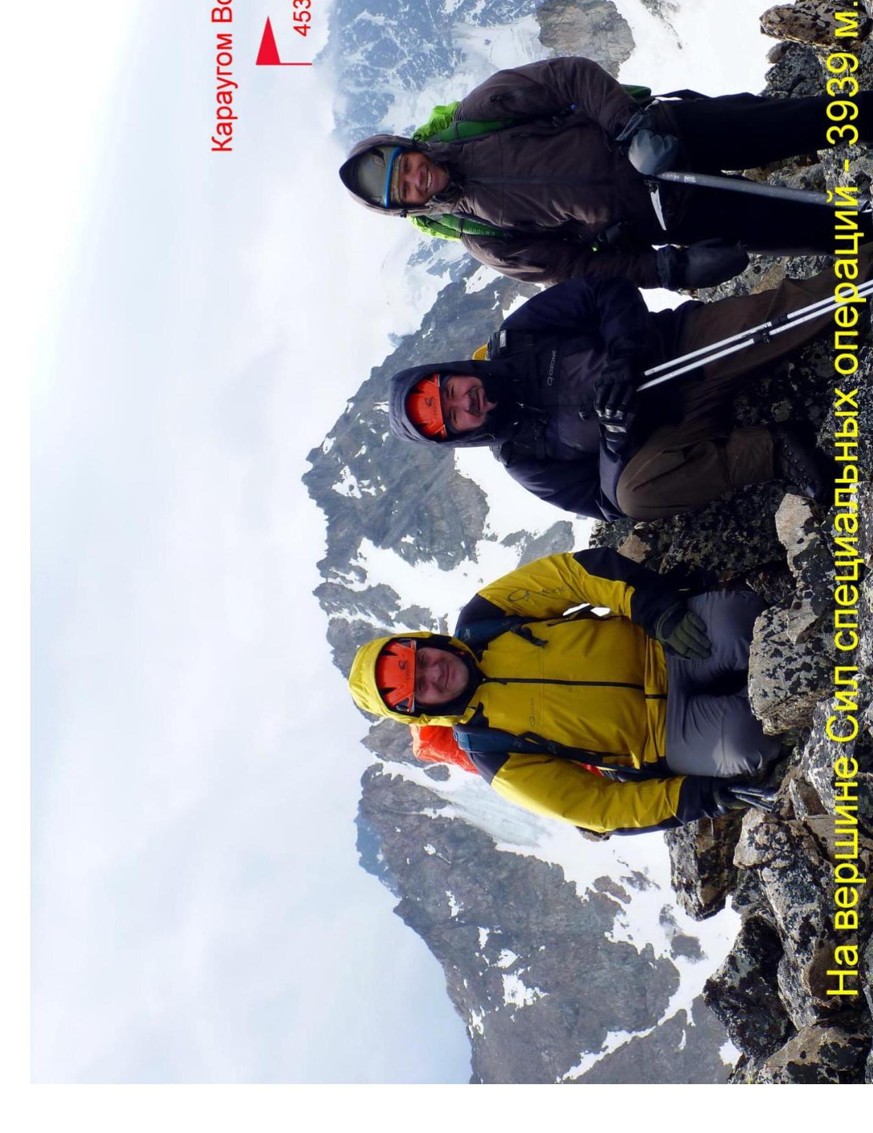
R4–R5: Bypass the summit rock step on the ridge to the left, on broken rock (category 1–3, 30–50°), for 30 m to reach the ridge. Then continue directly along the ridge (category 1–2) for another 30 m to reach the summit of peak 3939 m. It takes 5 hours from the campsites (we had to wait out a brief thunderstorm in the upper part of the route). The summit is distinct. It offers a panoramic view of peaks Karaugom, Tsakhfedor, Khuppara, and the mountains of Western Digoria. No signs of other groups were found. No notes or cairns were discovered. Summit coordinates (GPS): 42°50′10.96″ N; 43°45′5.78″ E. Descend via the ascent route.
Findings and Route Recommendations
The route corresponds to category 1B. Due to its predominantly ridge character, the route is safe. Protection on the route is via rock outcrops. Recommended for training and sports groups.
No border permit is required to visit the Sardidon and Khuppara valleys. Mobile phone coverage is lost after crossing the Dunta pass.
The ascent to peak 3939 m was dedicated to:
- The third anniversary of the Special Operations Forces of the Russian Ministry of Defense, which took place on August 27, 2017.
- The memory of those who died in the line of duty from the unit.
In December 2016, a letter signed by the Deputy Minister of Defense was presented to the Chairman of the Parliament of the Republic of North Ossetia, Machnev A. V., requesting that the new name of the peak be approved by the Parliament. To date, the process of officially registering the height 3939 m as the peak of the Special Operations Forces is ongoing.
Technical Photo of the Route
 Technical photo of the route
1. Introduction
This document provides an overview of key concepts and methodologies used in the study of quantum mechanics. It covers:
- Fundamental principles
- Mathematical formulations
- Practical applications
2. Fundamental Principles
2.1 Wave-Particle Duality
Quantum mechanics introduces the concept of wave-particle duality, where particles such as electrons and photons exhibit both wave-like and particle-like properties. This duality underlies the understanding of quantum system behavior.
2.2 Superposition
The superposition principle states that a quantum system can exist in multiple states simultaneously until a measurement is made. This is mathematically represented by a wave function, denoted as |ψ⟩.
2.3 Uncertainty Principle
Heisenberg's uncertainty principle states that it is impossible to simultaneously know the position and momentum of a particle precisely. This is expressed as: $Δx ⋅ Δp ≥ \hbar/2$, where
- $Δx$ is the uncertainty in position;
- $Δp$ is the uncertainty in momentum;
- $\hbar$ is the reduced Planck constant.
3. Mathematical Formulations
3.1 Schrödinger Equation
The Schrödinger equation is the fundamental equation of quantum mechanics, describing how the quantum state of a physical system changes over time. It is given by: $i\hbar \partial/\partial t \Psi(r, t) = \hat{H} \Psi(r, t)$, where
- $\Psi(r, t)$ is the wave function;
- $\hat{H}$ is the Hamiltonian operator.
3.2 Dirac Notation
Dirac notation is a convenient way to represent quantum states and operators. It uses bracket notation, where a quantum state is described by a state vector, and the bracket notation is used to represent quantum states and operators.
4. Practical Applications
4.1 Quantum Computing
Quantum computing leverages the principles of superposition and entanglement to perform computations that are infeasible for classical computers. Quantum bits, or qubits, are the fundamental units of quantum information.
4.2 Quantum Cryptography
Quantum cryptography uses the principles of quantum mechanics to secure communication. Quantum key distribution (QKD) is a cornerstone of quantum computing, where key distribution is used to identify key quantum states.
5. Conclusion
Quantum mechanics is a cornerstone of modern physics, providing a framework for understanding the behavior of particles at the demands of "quantum mechanics". Its principles and mathematical formulations have led to groundbreaking technologies and continue to inspire new research and development.
6. References
- Griffiths, D. J. (2005). Introduction to Quantum Mechanics. Pearson.
- Shankar, R. (2012). Principles of Quantum Mechanics. Plenum Press.
 At the summit of Special Operations Forces — 3939 m.
 Start of section R3-R4
 Start of section R4-R5
Digitized with Google1
Footnotes
-
4530 m ↩