
Russian Alpine Federation Classification Commission
We request to include in the classification table a route to the peak Kaltberg East, 3300 m, with an ascent via the NE wall of Monakh (first ascent, approximately 5B category of difficulty), climbed by a team of instructors from the "Tsey" alpine camp during the III Championship of the Caucasian Territorial Administration of Alpine Camps in 1983 (rock climbing category).
The ascent report was submitted at the time, but apparently was not reviewed due to technical reasons.
Vice-President
Alpinism Federation of Ukraine
Zagirnyak M.V.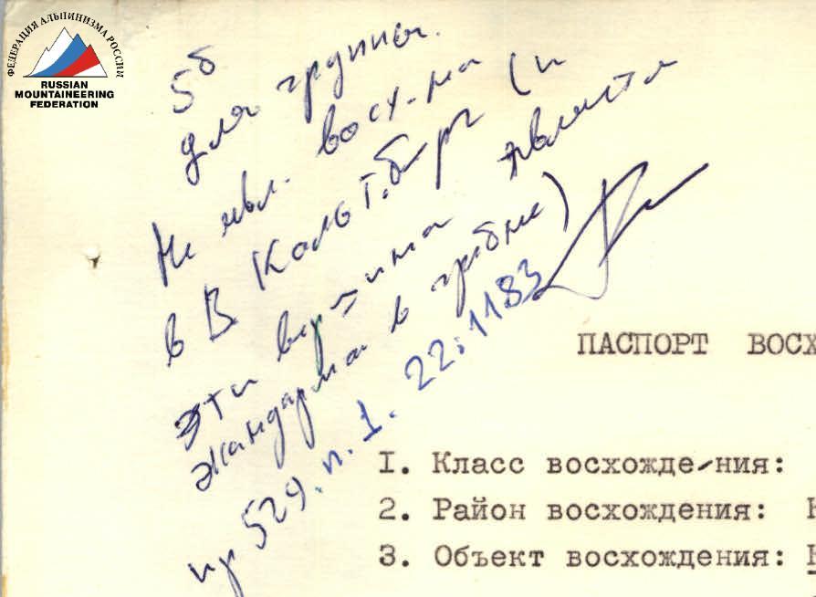
Ascent Passport
- Ascent category: rock climbing
- Ascent area: Caucasus, Tsey valley
- Object of ascent: KALTBERG East, 3300 m, ascent via NE wall of Monakh
- Proposed category: 5B, first ascent
- Height difference: 1200 m
Route length: Monakh wall — 800 m, ridge section — approximately 2000 m. Length of sections with 5–6 category of difficulty: 430 m. Average steepness of main sections (Monakh): 68°. Parameters of 6th category section: 110 m, 90°.
-
Pitons used: Rock pitons — 116 / 21 Bolt pitons — 6 / 4 Chocks — 310
-
Team's total climbing hours: 40 hours, 4 days
-
Night halts: 1 — on a ledge, in a tent 2 — on small ledges on the slope, unable to set up a tent 3 — comfortable
-
Team composition: Leader: Volkov Leonid Borisovich, Master of Sports, instructor-methodologist 1st category Participants:
- Martynov Alexander Ilyich, Candidate Master of Sports, 1st category
- Litvinov Anatoly Nikolaevich, Candidate Master of Sports, 2nd category
- Zagirnyak Mikhail Vasilyevich, Candidate Master of Sports, 2nd category
- Suprun Valery Ivanovich, Candidate Master of Sports, 3rd category
-
Coaches:
- Neborak Valentin Stepanovich
- Sukharev Vladimir Nikolaevich
-
Dates of ascent: July 13–14, 1983 — processing the first 100 m of the route; July 15, 1983 — starting the ascent; July 18, 1983 — return
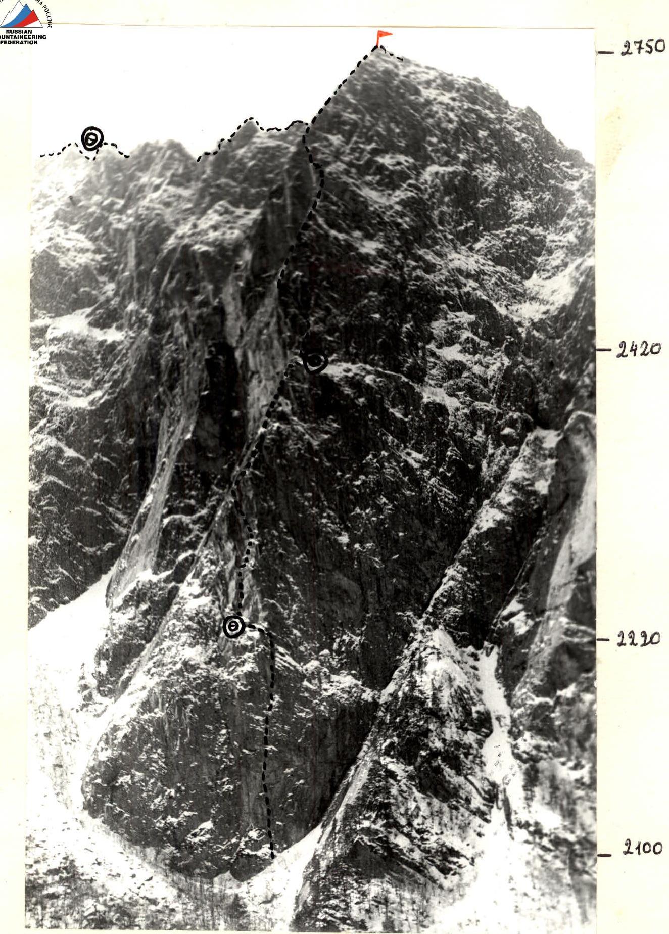
PHOTO 1 GENERAL VIEW OF "MONAKH"
Taken on February 22, 1983, 13:00
Lens Industar 50, F = 50 mm, L = 2000 m, h = 2400 m, point # 2.
PHOTO 4A PANORAMA OF THE TERMINAL PART OF THE S. SPUR (view from the right, point 5)
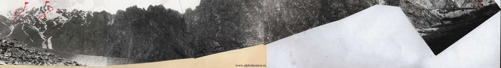
Characteristic view of peak East Kaltberg. Visible are the drops to the right and left of the summit and the ascent paths via the couloirs from the Tsey valley.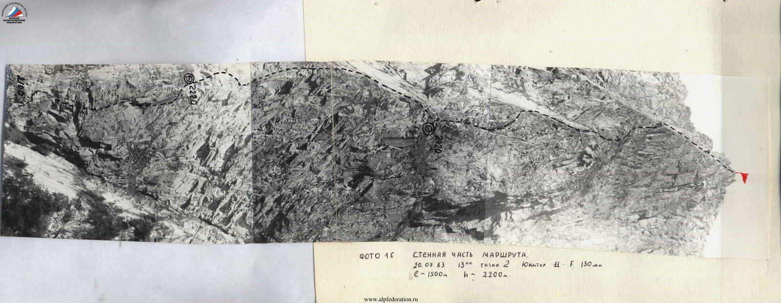
PHOTO 1B WALL SECTION OF THE ROUTE. July 20, 1983, 13:00, point 2, Jupiter 11, F = 130 mm, e ~ 1500 m, h ~ 2200 m. www.alpfederation.ru
PHOTO 10 RIDGE SECTION OF THE ROUTE July 11, 1983, 13:00, Point 3, Lens "Industar-50", F = 50 mm.
Brief Overview of the Ascent Area
The object of ascent — Kaltberg East — is located in the northern spur of peak Adai-khokh (4410 m). Starting from the snow-ice dome of Adai, the snowy ridge gradually descends to peak Kaltberg, which is represented by several rocky gendarmes on a common base. Continuing further north, the ridge becomes purely rocky and acquires a sharply dissected character. Characteristic features include:
- sharp gendarmes;
- rocky "feathers";
- sections inclined to the south. The ridge rocks are monolithic, with steep and overhanging walls, often making it difficult or impossible to bypass them.
A significant rise in the ridge is East Kaltberg (3300 m), a standalone peak with height differences of up to 300 m to the nearest cols on either side. The southern col is an easily accessible pass between the basins of the Tseydon and Skazdon rivers. From East Kaltberg, the ridge continues for approximately 2 km north to peak "Monakh" (2750 m). The northern, northeastern, and eastern slopes of "Monakh" are steep walls with height differences of up to 600–700 m. There are no easy ascent routes from here. The ridge between Monakh and Kaltberg East is replete with sharp gendarmes and significant drops.
Until now, only two routes had been established to the peaks of the northern spur of Adai-khokh, both on Kaltberg with 1st and 2nd categories of difficulty. The section of the ridge between Monakh and Kaltberg East and Kaltberg had not been climbed until now. According to local residents of the Tsey valley, an ascent was made on Monakh via the forested balconies on the right part (1962, I. Akrifov, R. Abduramanov). The steep rocky walls of Monakh, located in the very center of the picturesque Tsey valley, have long attracted the attention of not only tourists but also climbers. Ascents similar to the one accomplished were planned by B. Levin and V. Lavrenenko in 1971, L. Volkov and V. Sukharev in 1981, and A. Litvinov and V. Kozyrev in 1982, but for various reasons, these ascents were not realized.
The approach to the route is straightforward, visible from the "Tsey" alpine camp, and takes 20–30 minutes via the trail on the left bank of the Skazdon river. It should be noted that further exploration of peak East Kaltberg and Monakh is possible, with routes of 2–5 categories of difficulty potentially being established.
 www.alpfederation.ru
www.alpfederation.ru
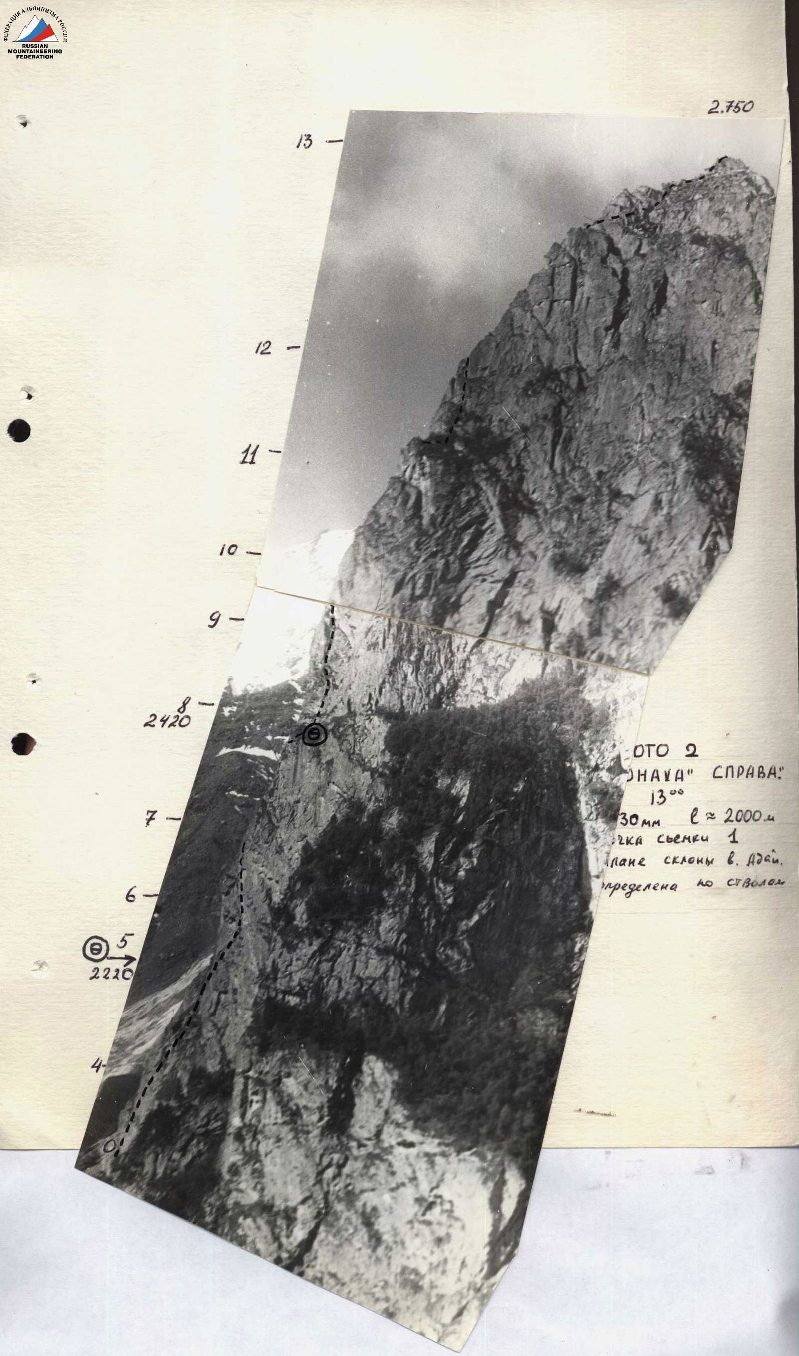
PHOTO 3 PROFILE OF "MONAKH" FROM THE LEFT Taken on July 20, 1983, 13:00, "Jupiter-11", F = 130 mm, L ~ 2000 m, h ~ 2500 m, Point 4.
PHOTO 4 PHOTO PANORAMA OF THE AREA (N. spur from peak Adai-khokh to "Monakh") Taken on July 20, 1983, 11:00, "Industar-50", F = 50 mm, L ~ 1.5 km, h ~ 2300 m, point 2. Routes climbed on the peaks of the massif:
- Adai via the E. wall, 4B category of difficulty
- Kaltberg via the E. slope of the N. ridge, 2A category of difficulty
- Route of the team.
Adai 4408 m, Kaltberg 4120 m.
ROUTE SCHEME IN UIAA SYMBOLS
Route Description by Sections
The route can be conditionally divided into parts:
- lower wall section (sections R0–R5);
- first ascent and edge (sections R5–R8);
- second ascent and edge (sections R8–R11);
- third ascent and ridge to the summit (sections R11–R13);
- ridge Monakh – East Kaltberg (section R13 – peak East Kaltberg).
-
Lower wall section — a wall with a double cornice tier. The overhang of the cornices from the wall is about 1 m (see photo illustrations). The overall steepness of the section reaches 95° in places. Climbing is very challenging, section R1–R2 is exclusively on artificial technical aids (ITAS). There are insufficient places for piton placement, so bolt pitons were used for safety and ITAS. Passing the wall required the use of ladders, platforms, and "skyhooks." A "Zeiltsug" was also used. The start of the route is the lowest point of the wall. On the first rope (section R0–R1), the team left and marked with blue paint pitons for safety (for conducting classes and certifications with junior ESS climbers of the alpine camp). The further passage of the route is fairly clearly reflected in the UIAA scheme. At the top of the wall, a short ledge leads to a bivouac site. The first control cairn is suspended in a bag in a crack under an overhang at the end of section R2–R3.
-
First ascent and edge. From the bivouac, upward to the right along a departing crack with a crack — challenging climbing under an overhang, which is passed on the left via the crack. Then through wedged blocks — exit to a ledge with a small tree (here is the second control cairn in a plastic flask). Along the ledge about 8 m to the right to an edge formed by large, tile-like rocks. 12–15 m upward and then left upward along steep rocks with few handholds. Climbing is of extreme difficulty, with insufficient places for piton placement. Further (section R7–R8) along the slabs on the left side of the edge — toward the second ascent. Under it, on a system of ledges — a bivouac. It is not possible to set up a tent.
-
Second ascent and edge. From the bivouac, upward to the right along a wide internal angle (section R8–R9, 50 m). Then left-upward through a system of internal angles and a wall, bypassing overhanging sections on the left — exit to an edge. Along the slabs and cracks on the left side of the edge — movement with alternating safety to under the third ascent. Here is also a possible bivouac site.
-
The third ascent is passed:
- initially to the right along a steep, moss-covered wall — 20 m;
- then along an internal angle-crack with a wedged rock at the top — 20 m;
- after which along the slabs on the left part of the edge another 40 m to the end of section R11–R12. The pre-summit ridge (section R12–R13) does not present particular problems. Movement is almost to the summit of Monakh with alternating safety. Gendarmes in the ridge are bypassed on the right. On the summit of Monakh — a control cairn.
-
The ridge Monakh — East Kaltberg is about 2000 m long (estimated in comparison with the known length of the cable car). It is sharply dissected, featuring a number of sharp gendarmes. The path to overcome the gendarmes is shown on the scheme. The key location of this part of the route is the ascent to the "nose" of the gendarme "Teapot." It is climbed first without a backpack, wearing galoshes. Ascending the remaining gendarmes or bypassing them does not present particular difficulty, but descending from them often required rappelling.
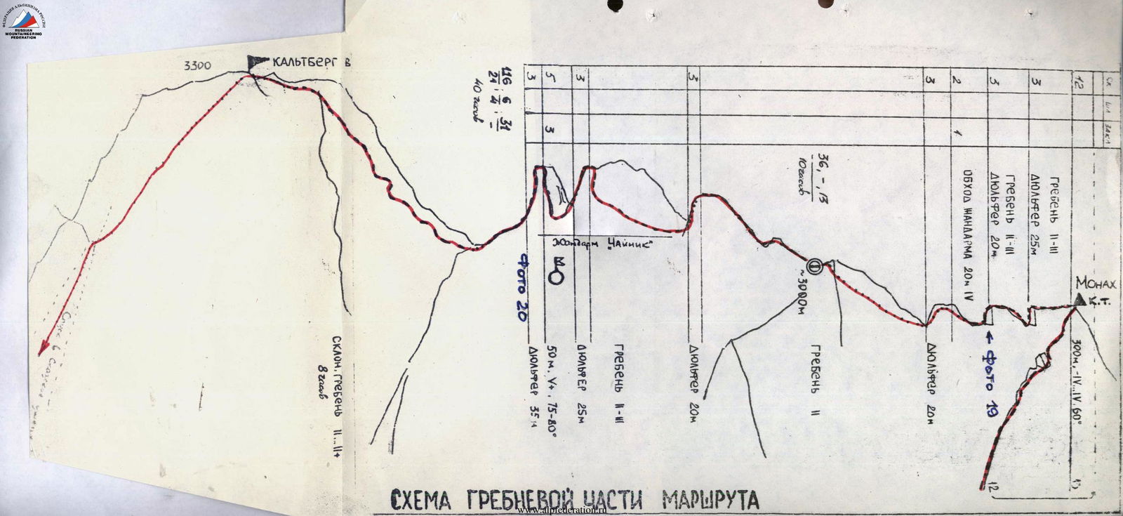
SCHEME OF THE RIDGE SECTION OF THE ROUTE
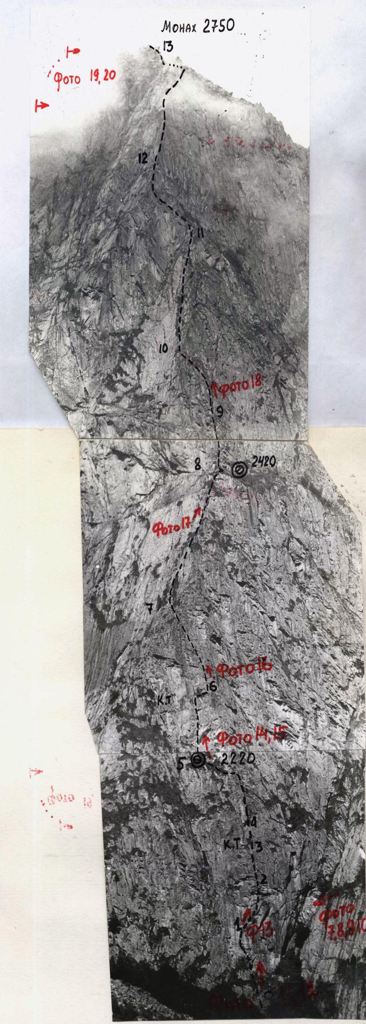
PHOTO 5. TECHNICAL PHOTO OF THE ROUTE.
Taken on July 13, 1983, 14:00. Jupiter 11, F = 130 mm, shooting point 2, e ~ 1500 m, h ~ 2250 m.
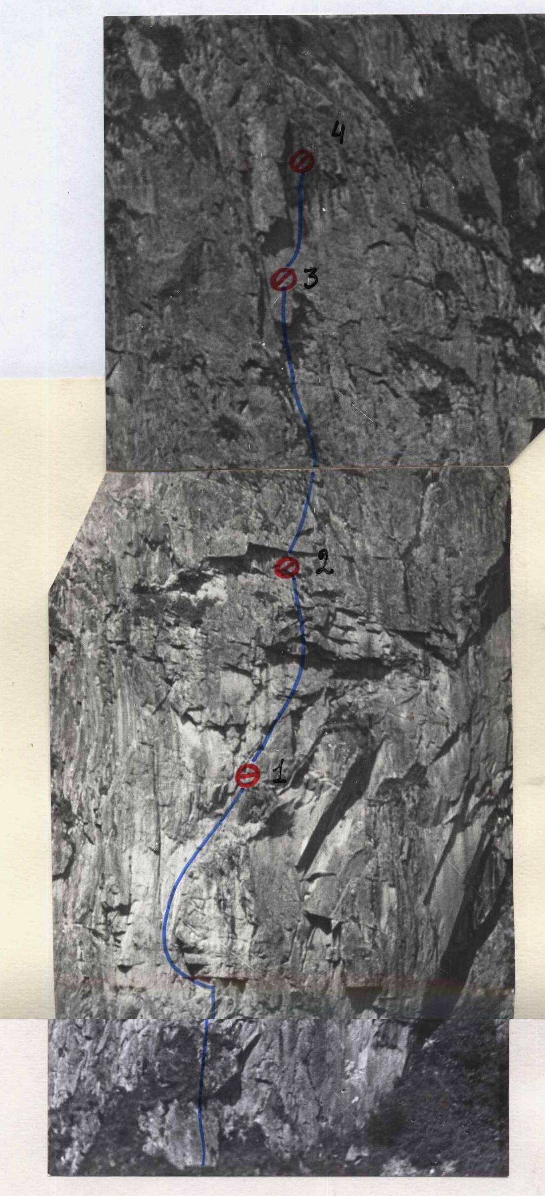
PHOTO 6. PROCESSED SECTION OF THE WALL.
Ropes and rope anchors are marked.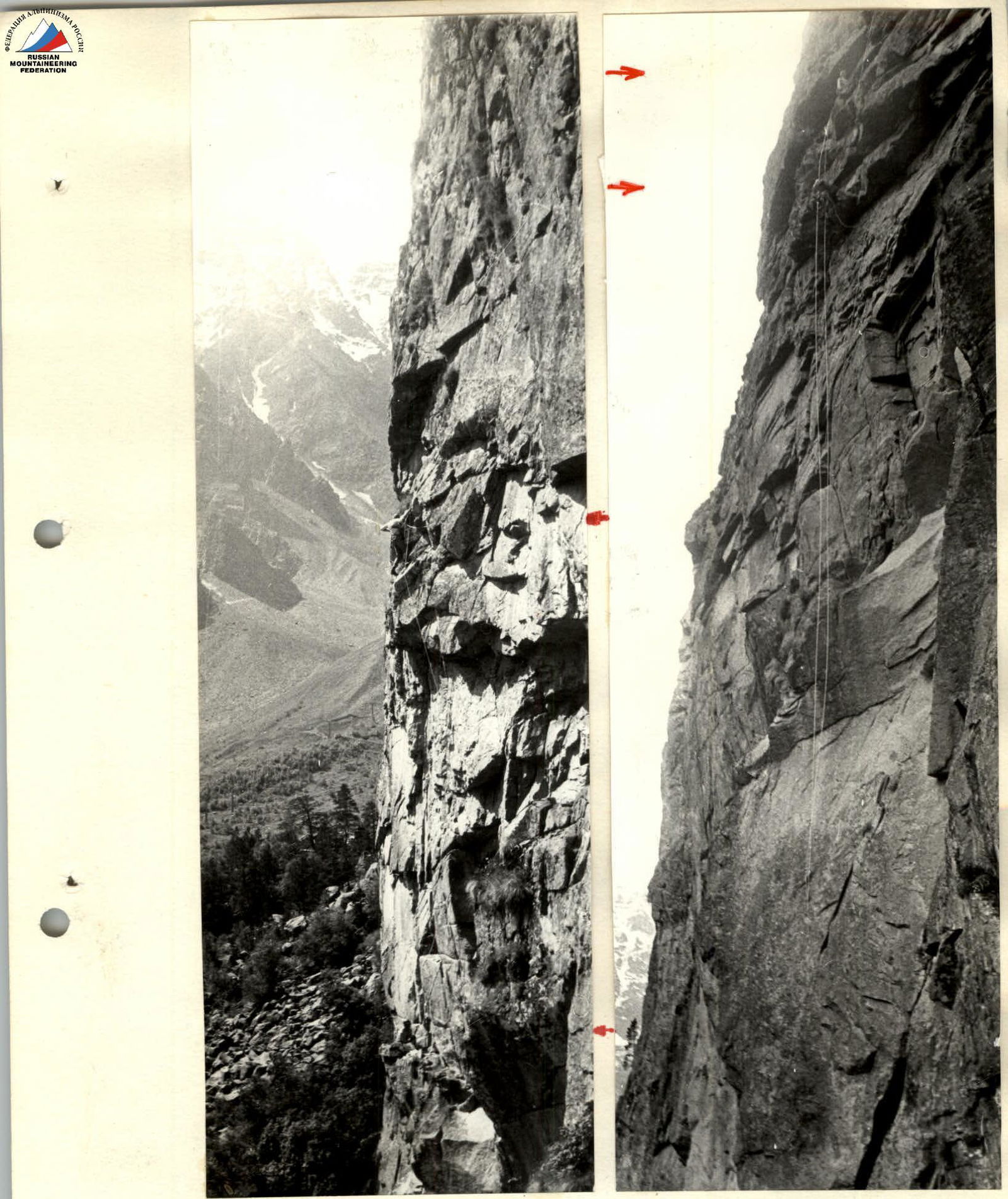
PHOTO 7–8. PROCESSING SECTION R1–R2–R3. July 13, 1983, 12:00, 14:00. Industar-50. F = 50 mm. Time taken — 6 hours.