- Climbing type: rock climbing
- Climbing area: Caucasus, Tsey Gorge, Eastern spur of Kaltberg peak
- Peak, route: Monakh (2760 m) via the left Southeastern edge
- Estimated difficulty category: 5B, first ascent
- Height difference: 460 m
— of which the wall part is 410 m — total route length is 520 m — wall part length is 450 m — of which:
5 — 175 m 6 — 25 m
— average steepness of the wall part is 70° — average steepness of the route is 65°
- Pitons driven:
rock 35/0, ice 0/0, chock stones 36/0, bolt pitons 1/0
- Duration: 10 hours / 1 day
- Overnight stays: 1st on descent from the summit, on the ridge, comfortable, lying down
- Leader: Egorin Sergei Vladimirovich, Candidate for Master of Sports, born 1971
Participant: Ivanov Vitaly Valentinovich, Candidate for Master of Sports, born 1973
- Coach: Korablin Boris Nikolaevich, Master of Sports, Honored Coach of the RSFSR
- Approach to the route: September 21, 1996
Summit: September 21, 1996
Return: September 22, 1996

Photo 1. Overall photo of Monakh peak. View from the South. The route of the first ascent is marked in red. The route taken by L. Volkov's group in 1983 is marked in blue. Photo taken in early March 1996, around noon. T-43 lens, focal length 40 mm. Distance to the Southeastern edges is about 1 km. Shooting height is about 2250 m; morhaeww.alpfederation area F1.
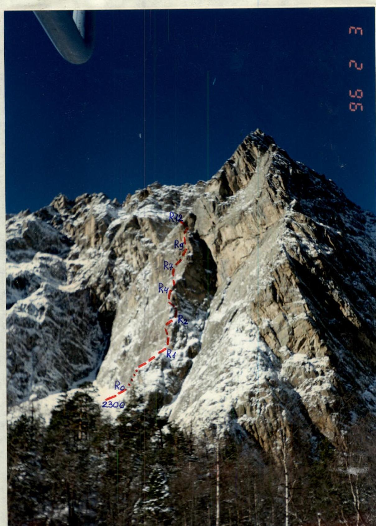
Photo 2. Route profile from the right. The route of the first ascent is marked in red. Taken in early February 1996, around noon. T-43 lens, focal length 40 mm. Distance to the route is about 0.5 km. Shooting height is about, point on the map of the area F2.
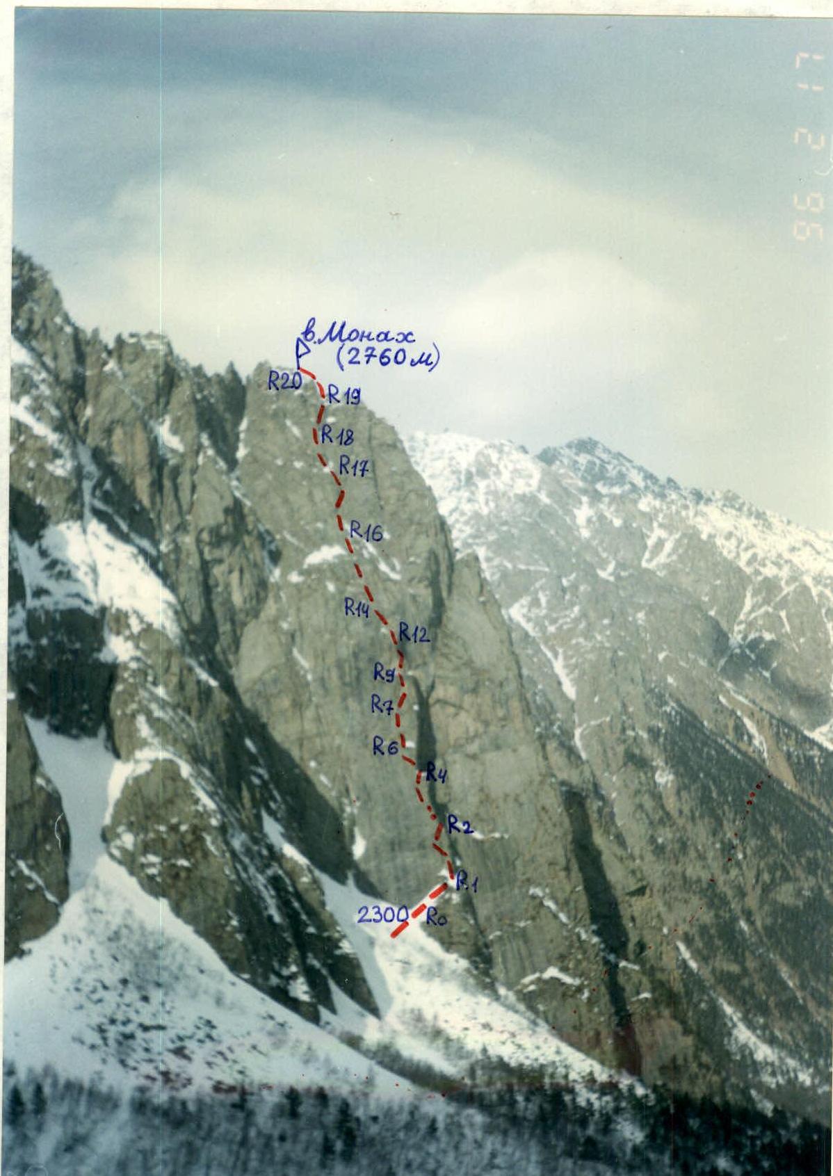
Photo 3. Route profile from the left. The route of the first ascent is marked in red. Taken in mid-February 1996, around noon. "Premier" lens, focal length 35 mm. Distance to the route is about 1 km. Shooting height is about 2350 m; point on the map www.alpfederation.ru↗.
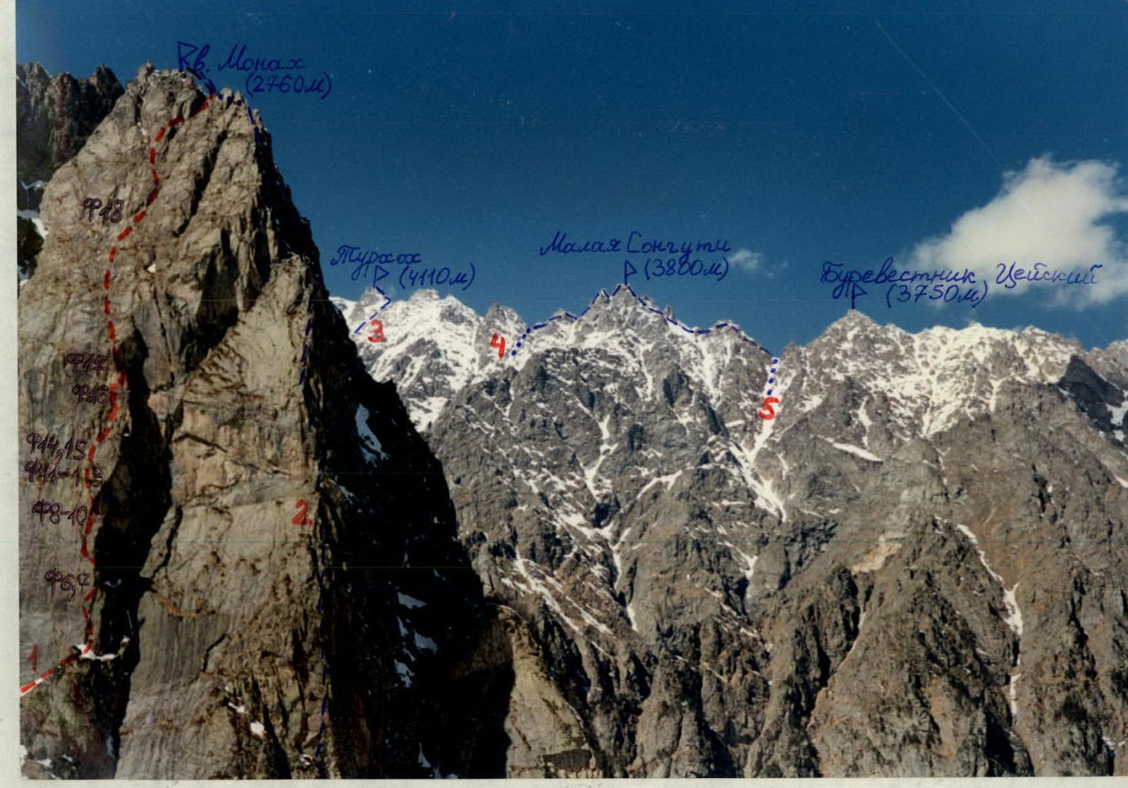
Photo 4. Panoramic photo of the area. 1 denotes the route of the first ascent. 2 — L. Volkov's route on Monakh in 1983. 3 — route to Turosokh via the Eastern ridge, category 1B. 4 and 5 — routes on Malaya Songuti via the Western ridge, category 3B, and via the Eastern ridge, category 3A. Taken in March 1996, around noon. T-43 lens, focal length 40 mm. Distances: to Monakh about 1 km, to Tsey's Burevestnik about 5 km. Taken from 2250 m; point on the map F4.
Brief overview of the climbing area. History of the peak's exploration.
Tsey Gorge is located in the territory of the Republic of North Ossetia-Alania, between the Ardon and Urukh rivers. In its upper reaches, the Tseydon River receives the Skazdon River as a right tributary. The watershed of the Tseydon and Skazdon basins is the Eastern ridge of the Adai-khok peak (4408 m). Initially, it forms the Kaltberg peak (4120 m), then, sharply descending to the east and dropping below the "snow line," this ridge becomes purely rocky with talus slopes.
One of the most pronounced "gendarme" of this ridge was named "Kaltberg East" peak by L. Volkov's team in 1983, with a height of about 3400 m. Beyond it, the ridge continues further east and, passing by the "Teapot" gendarme, easily recognizable from almost anywhere in the Skazdon River gorge, it descends to a height of about 3000 m. Here, on the ridge and on the shelves, grass begins to appear.
The Eastern ridge of the Adai-khok peak ends not far from all the alpine camps with a peculiar gendarme — the Monakh peak (2760 m), the height determined by us using an aviation-type altimeter. Monakh peak drops to the south, east, and north with sheer walls with differences of 400 to 600 meters, which have caught the attention of more than one generation of climbers. In some places on the walls, there are whole terraces overgrown with grass and trees. Some walls are quite promising for climbing. There are also logical edges and counterforts leading to the Monakh peak.
The exploration of Monakh was practically not carried out, likely due to:
- the low height of the peak,
- the presence of grass on the shelves,
- lichen on the rocks,
- moss on the north-facing walls,
- the great steepness and complexity of potential routes.
According to our information, the first ascent of Monakh was made by a duo: R. Abdurakhmanov and I. Akitov, sometime in the early 1960s. They ascended via the Eastern slope, bypassing almost all the complex areas (except the top) along the grassy shelves and terraces.
In fact, the beginning of the sporty exploration of Monakh's walls was laid in July 1983 by a group led by L. Volkov. They ascended the most interesting route, in sporting terms, and the most logical route to Monakh — via the Eastern edge of the Kaltberg East gendarme (3400 m), although the actual orientation of this edge is southeast. The route they ascended is quite strong, especially in the lower part of the wall of this edge.
Despite this, their route was classified:
- firstly, up to Kaltberg East, which is illogical;
- secondly, as 5B for the group, probably because at that time the so-called "small mountains" were not classified — especially in an area with many four-thousanders.
Although there is enough for a 5B on one edge on Monakh, and still, the route probably deserves an official classification. After 1983, it seems that no group has fully completed L. Volkov's team's route.
Brief description of the approach to the route.
From Vladikavkaz city, by car to the "Torpedo" or "Tsey" alpine camps is about 2.5 hours; or by bus to the Buron settlement (about 2 hours), then by hitchhiking to the alpine camps or about 2.5 hours on foot.
The further path goes up the Skazdon River gorge along a dirt road, along the "canatka." Upon reaching the 11th support, turn right — to the north, from here both Southeastern edges of Monakh peak (2760 m) are clearly visible.
Then:
- Cross the Skazdon River by wading or on stones.
- Move first through the forest, then through overgrown large-block talus.
- Approach the base of the left Southeastern edge of Monakh peak.
From the Tsey Gorge alpine camp, it takes about 1 hour.
Team's tactical actions.
The ascent was carried out without deviations from the tactical plan in terms of time and overnight stays. We planned to complete the route in a day and spend the night on the descent. For this, we set out from the alpine camp before dawn. And indeed, we managed to reach the summit and start descending within a day. If not for the fog, we would probably have descended into the gorge by dusk; since we had previously surveyed the descent route. But we had to spend the night on the ridge during the descent, with everything needed for an overnight stay — a tent, food, gear, etc.
The next day, as planned, we descended to the alpine camp from the overnight stay spot in 3 hours.
On the route, due to the complex terrain and the great steepness of the rocks, the first climber almost always moved without a backpack and in rock shoes. His backpack was then pulled up by a safety rope for the second climber — the safety of the second and the pulling of the first's backpack happened simultaneously and with one rope: the backpack was tied 2–3 m above the second climber, and on challenging sections where the backpack got stuck, he would push it.
The second climber moved mainly on fixed ropes and often, due to the significant steepness of the rocks, with two jumar clamps.
Both climbers always moved on a double rope. We took ropes of different colors, 50 m each:
- One — 8.6 mm in diameter — safety rope,
- The other — 11 mm — fixed rope.
Both ropes were of French production with a UIAA quality certificate.
The entire route was ascended using free climbing without the use of artificial aids. The only bolt piton we drove was in a problematic spot where it was otherwise impossible to organize safety.
Chock stones, especially friends, worked very well on the route. Stations consisted of both chock stones and pitons (often combined).
The leader's safety was ensured through an "eight" device and with leather gloves. Attachment points for fixed ropes or the first climber's safety, and the second climber's safety or self-belay — were always separate.
In the presence of trees, stations were made around them; otherwise, a station consisted of three (minimum) to four pitons or chock stones. Intermediate safety points were also organized.
On the descent, on the ridge, where the terrain allowed, the rope was also pulled behind ledges.
During the ascent, we did not stop for lunch: each had pocket snacks, and instead of water — apples. It was only during the overnight stay that we had hot drinks and food.
The overnight stay was in a tent, comfortable, lying down, and on the ridge — in a safe place.
The ascent showed a large reserve of physical and technical capabilities of the team, as there were no injuries or falls, and our duo descended from the summit with a significant reserve of strength.
During the ascent, we had constant communication with our observers and support team (rescue team) in Tsey, who could connect with the North Ossetian rescue service in Vladikavkaz at any moment. All of them are professional rescuers.
From the summit, we ourselves communicated with Vladikavkaz city via Japanese-made UHF radios.
In addition, throughout the day, while we were on the route, our coach, Korablin B.N., was down in the gorge, who could not only observe us with binoculars but also hear us.
The work planned with observers and the rescue team was carried out without deviations.
TABLE OF FOOD AND FUEL SUP-plies AND FUEL
| Item | Quantity | Weight/kg |
|---|---|---|
| gas | 1 cylinder | 0.3 |
| water | 2 liters | 2. |
| apples | - | 0.5 |
| cookies | - | 0.5 |
| sausage | - | 1. |
| cheese | - | 0.5 |
| dry puree | - | 0.5 |
| tea | - | 0.1 |
| chocolate | 1 bar | 0.1 |
| TOTAL: | - | 5.5 |

Approach the base of the left Southeastern edge of Monakh peak, bypass it on the left, and approach the grassy shelf leading right — upwards onto the edge.
Section R0–R1: Along the shelf 2, about 45 m, up to 45° to a balcony.
Section R1–R2: Upwards through a chimney 80–90°, 40 m, 5, to a shelf with a tree.
Section R2–R3: From the tree straight up the wall, wedging between the tree and the wall, 15 m, up to 90°, 5 and 5+. Then the route goes behind the edge, and the partner is not visible.
Section R3–R4: Upwards through a crack with grass, 25 m, 75–80°, 5.
Section R4–R5: From the shelf with a dried tree to the edge and traverse left. Before starting the traverse — a bolt piton. Then — to a crack, 5 m, 80°, 5+.
Section R5–R6: Through the crack to a shelf with a young tree, 15 m, up to 80°, 5. From the start of the edge — 3–4 hours.
Section R6–R7: From the shelf through cracks overgrown with grass, under rusty-colored cornices. Uncomfortable belay spot. 45 m, 85°, 5 and 5+.
Section R7–R8: Right — upwards under the cornice, 5 m, 6.
Section R8–R9: Along the нависающему internal corner to a shelf with juniper, 10 m, 95°, 6. Friends work well on this section.
Section R9–R10: From the right part of the shelf along the rusty walls upwards, first through a chimney, then along its right edge, 15 m, 80°, 5.
Section R10–R11: Having reached the edge and bypassed a stone on it, 6 m, 60°, 4, exit to a shelf. On it, under stones near a titanium piton — a control tur with a note.
Section R11–R12: From the left part of the shelf to the edge and along the нависающему internal corner upwards, 10 m, 95°, 6. Then the partner is not visible. Friends work well on this section. From the start of the route — 7–8 hours.
Section R12–R13: Having gone beyond the edge's corner along the wall to the left of a pine, 10 m, 60°, 4+.
Section R13–R14: Through cracks with grass to a shelf, 15 m, 70°, 5. Few cracks suitable for driving pitons!
Section R14–R15: Along the wall and shelves straight upwards, 40 m, 70°, 4 and 4+.
Section R15–R16: From a shelf overgrown with grass, along the wall 40 m, 60°, 3.
Section R16–R17: Along the right and left parts of a couloir-gutter another 50 m upwards, 50°, 3 and 3+.
Section R17–R18: Along the wall, to the left of the visible gap in the ridge ahead, straight upwards, 50 m, 60°, 4.
Section R18–R19: Under the walls, right — upwards along a grassy couloir to the ridge, 50 m, 45°, 3.
Section R19–R20: From the ridge's saddle left onto Monakh peak, along the ridge 30 m, up to 40°, 3. From the start of the route, about 10 hours.
On the summit, an overnight stay is possible under huge rock boulders.
The descent goes west towards Kaltberg peak. First, rappel straight from the summit 20 m, then bypass the ridge from the north and another rappel to the north about 20 m.
Then:
- Bypass all gendarmes on the right (along the northern slopes).
- Ascend to the ridge at the spot where a shoulder extends from the main ridge (before reaching the "Teapot" gendarme).
- This shoulder is walled on all sides except the one facing Adai-khok (to the west).
- From the shoulder, descend along the talus, larger lower down, into the Skazdon River gorge.
- Along the road to the alpine camp.
From the summit — 4–5 hours.
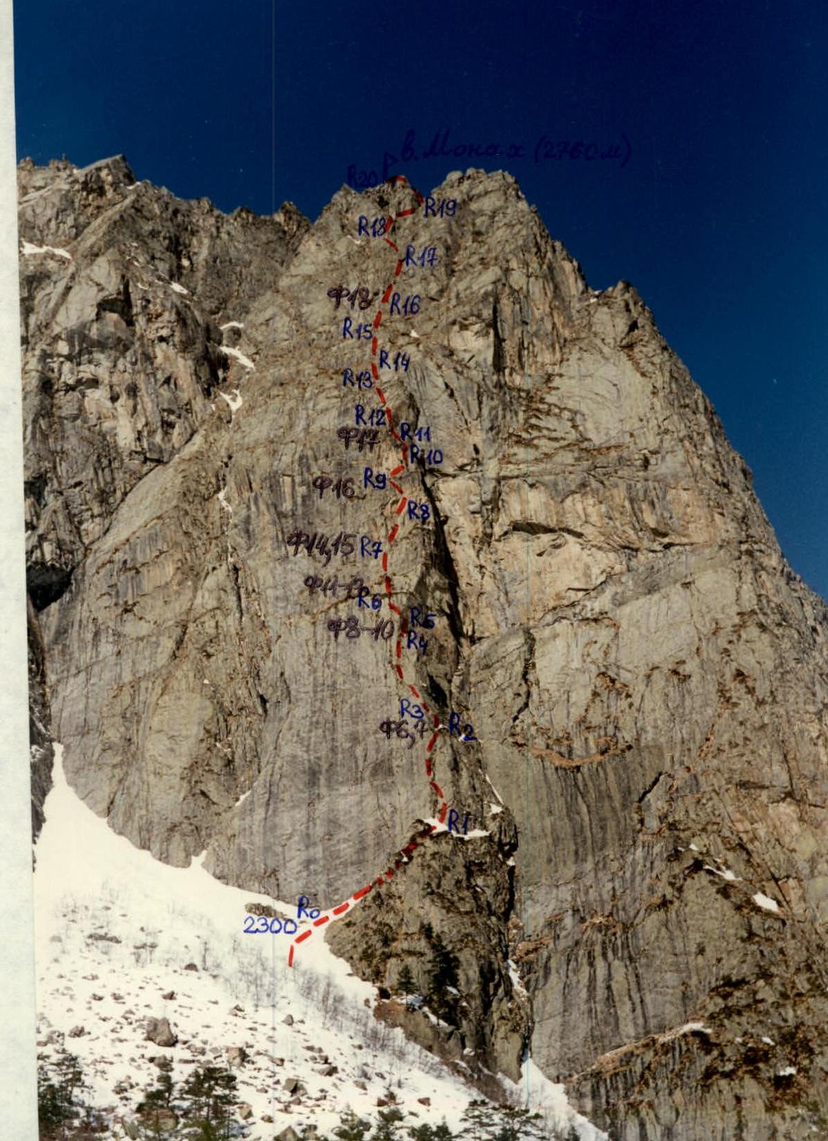
Photo 5. Technical photo of the route. Taken in early March 1996, first half of the day. PT-43 lens, focal length 40 mm. Distance to the start of the route is about 0.5 km. Shooting height is about 2200 m; point www.alpfederation.ru↗.
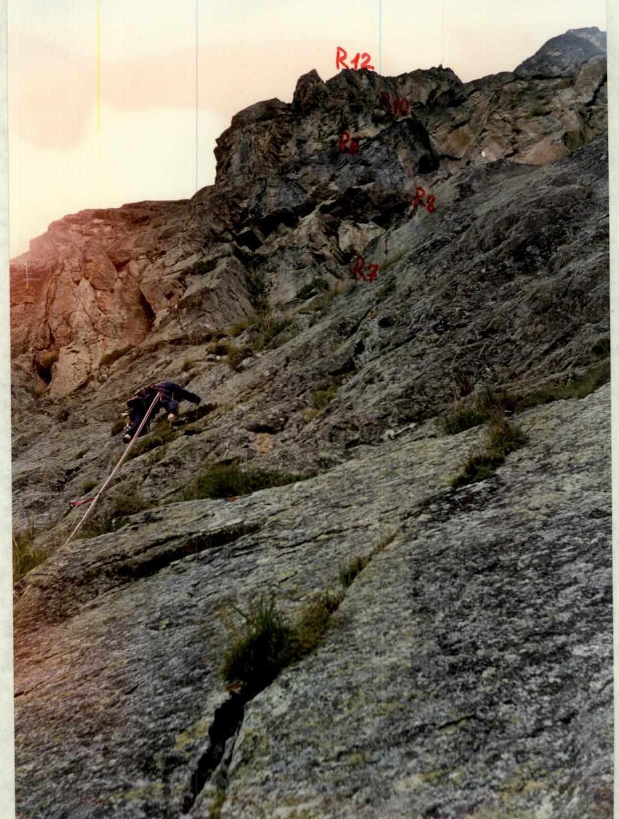
Photo 12. Passage of section R6–R7. Photo from R6, 21.09.1996, 10:45.
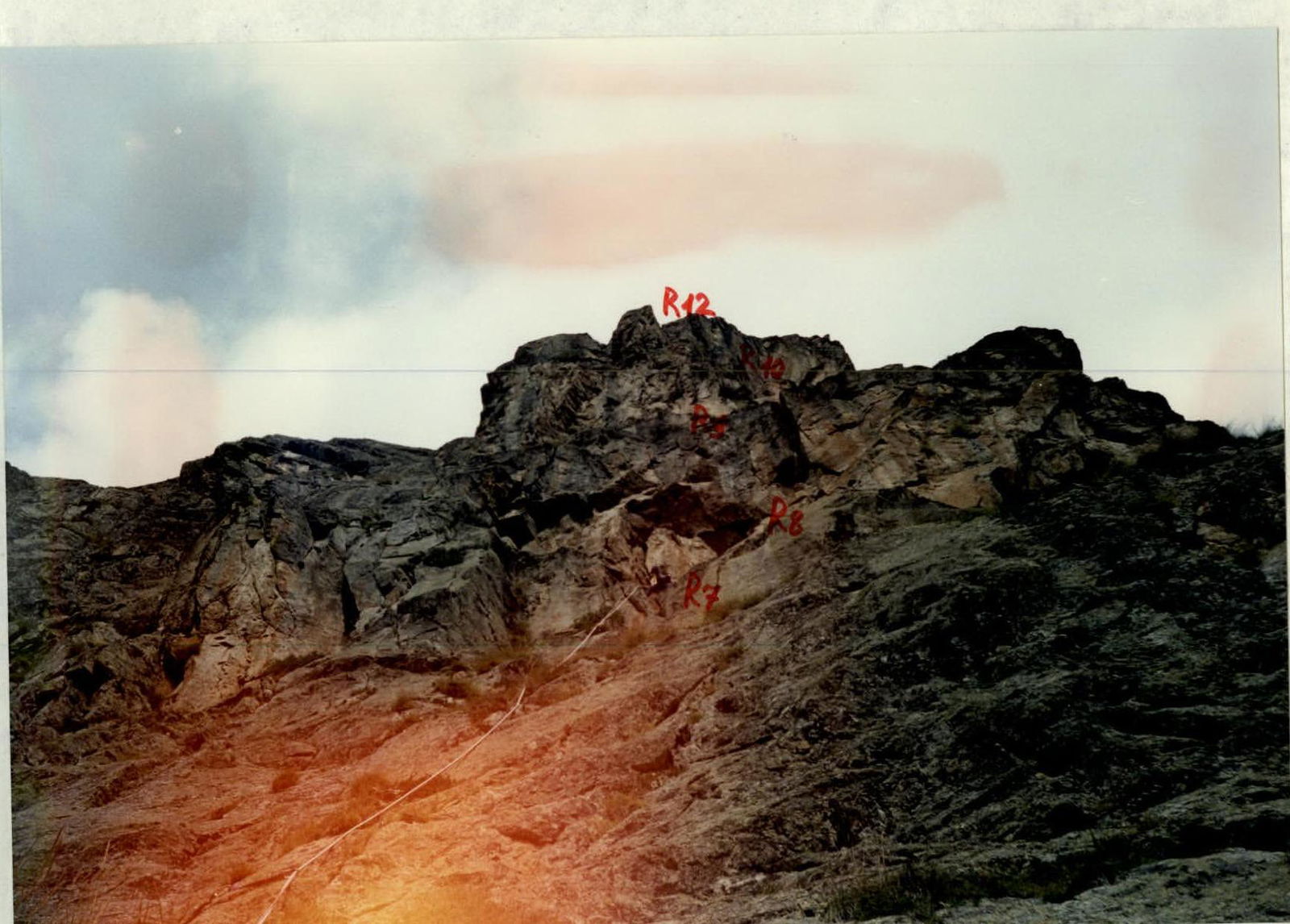
Photo 13. "Station" on R7. Photo from R6. 21.09.1996, 11:20.
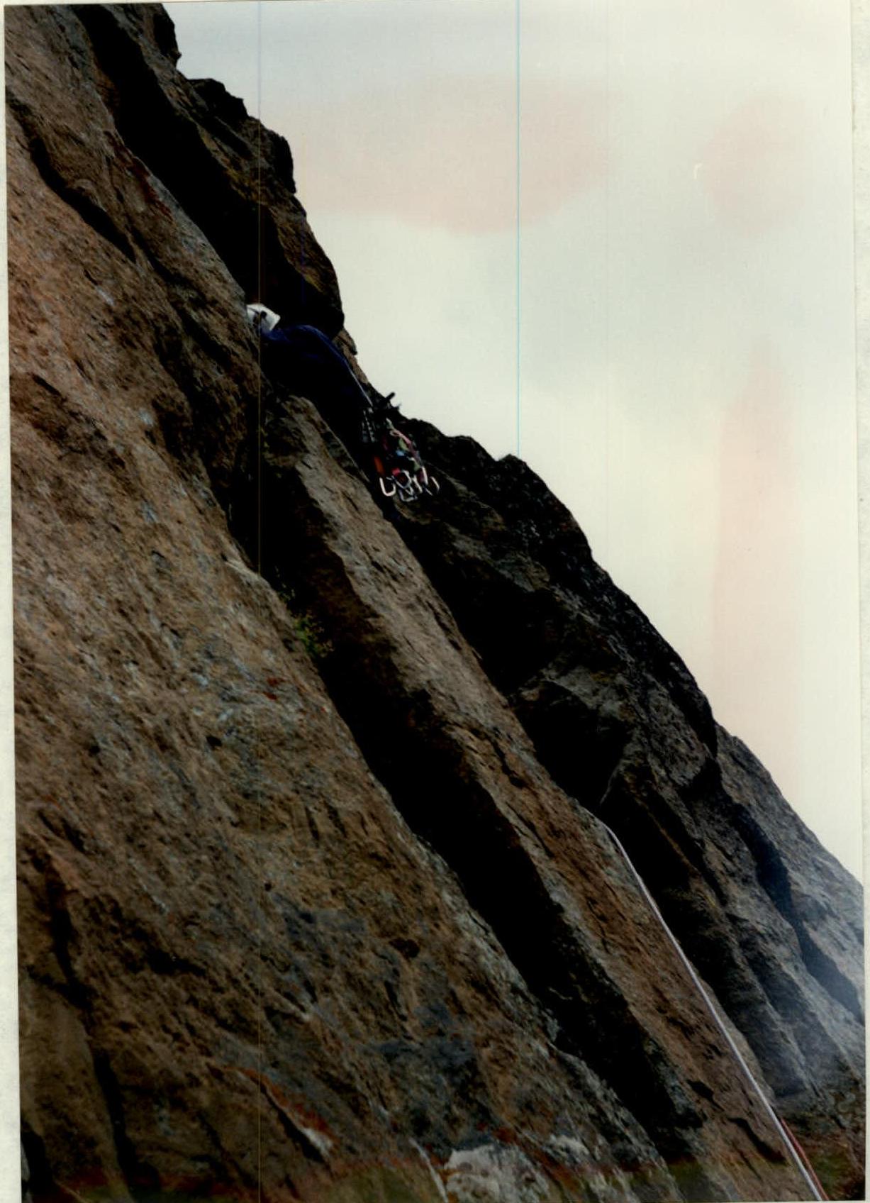
Photo 16. Up the chimney with a cork. Section R9–R10. Photo from R9. 21.09.1996, 13:15.
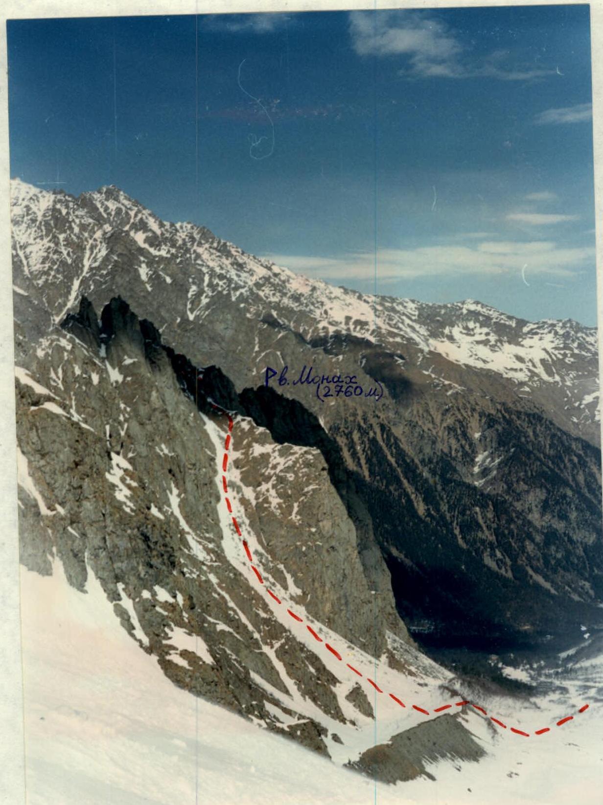
Photo 20. Descent path from Monakh peak (2760 m). Photo from the Skazdon glacier, March 1996.
Supplement.
Due to the ascent being carried out on the territory of the North Ossetian State Reserve, all pitons on the route were removed (except two). All garbage was collected and taken down. The ascended route can be compared in rock character — "steep, monolithic granite" — to Ruzhevsky's route on the Southern wall of Kirpich peak in Uzunkol, category 5B.
The route should only be taken in good weather, only when the rocks are dry, as almost all sections are done on friction and are somewhat covered in lichen, making them very slippery. If there is snow above section 12, further passage is also problematic, as there are many places that need to be traversed on steep grass. The entire route, along with the descent from the summit, is completed in one day only under ideal conditions:
- excellent state of the route,
- a strong group (preferably a duo),
- a long daylight period,
- good weather and visibility in the second half of the day,
- prior study of the descent.
Water should be taken on the route; snow is possible in the off-season on the north side of the ridge. It is better to use 50 m ropes on the route.
Note from Monakh peak:
July 13, 1989, 18:30
A group of instructors from the "Tsey" alpine camp consisting of: Mezentsev A. (leader) Vekslavovsky A. Dementiev Yu. Zubach V. Vilyk A.
completed an ascent to Kaltberg peak via the N.E. edge of Monakh peak, category 5B. Three peaks — tur monakh. The note of the first ascenders from July 17, 1983, was removed. Exit from the "Tsey" alpine camp at 6:30.