Ascent Passport
- Caucasus; North-Eastern ridge-branch of Kalthberg peak; section number in Classification 2.7.
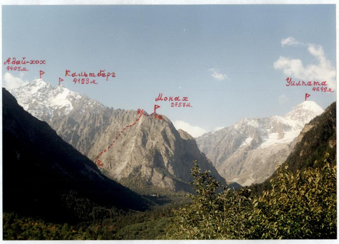
- Monakh peak — 2757 m; from South along South-West ridge.
- Proposed 2B category; first ascent.
- Route character — rocky.
- Route elevation difference — 400 m.
Length about 1400 m. Steepness of key route sections up to 90°. Average steepness of the whole route — 20°.
- Pitons left on the route — 5.
- Team's walking hours — 6 hours, days — 1.
- Leader: Egorin Sergey Vladimirovich — Master of Sports
Participant: Gagiev Viliam Taymurazovich — 2nd sports category
- Coach: Egorin S. V. — Master of Sports
- Date of ascent: August 29, 2001
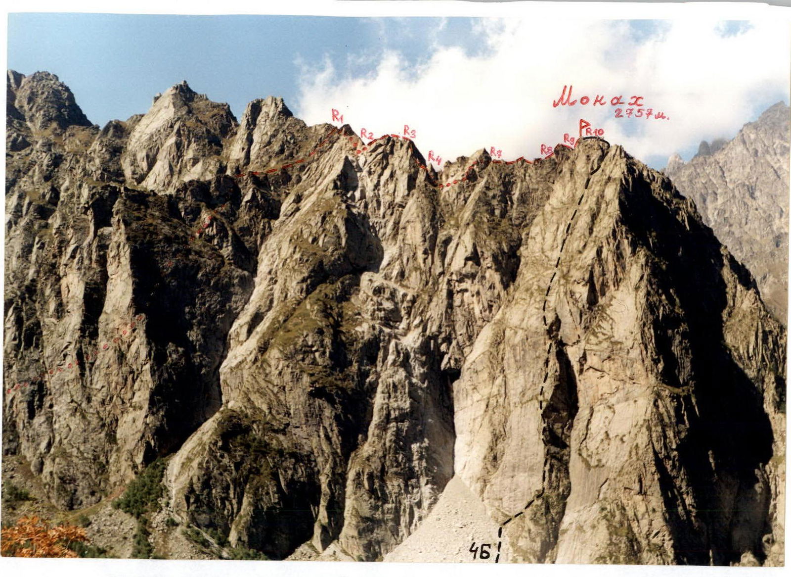
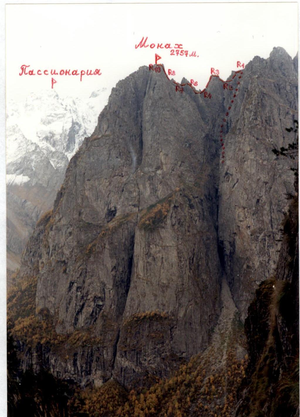
South-West ridge of Monakh peak. October. View from South-East. The first ascent route is marked in red. Black — 1996 route along the left South-East edge 4B category.
Brief overview of the ascent area. History of peak development
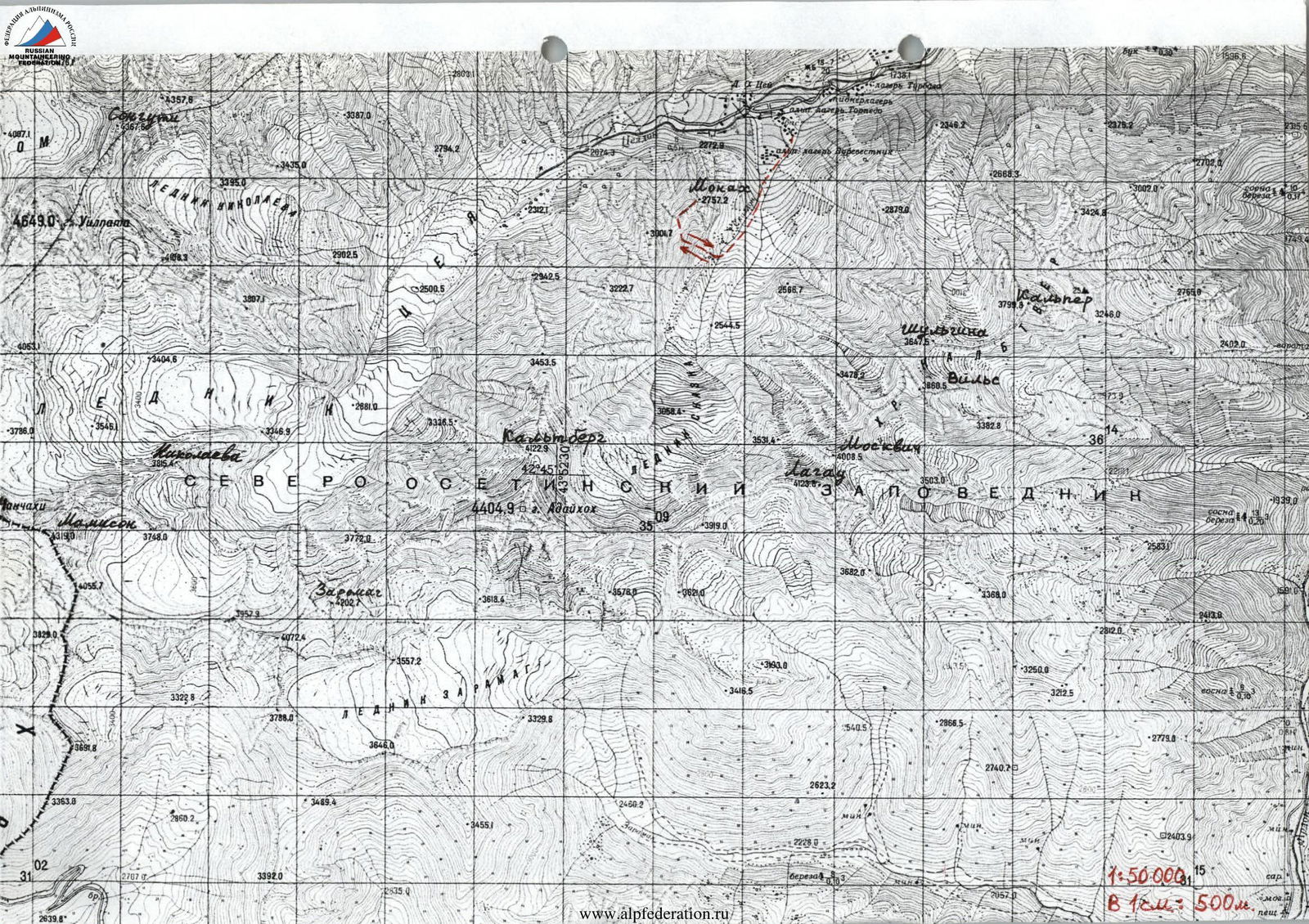
Tsey valley is located on the territory of the Republic of North Ossetia — Alania in the interfluve of Ardon and Urukh. In its upper reaches, the Tseydon river receives a tributary — the Skaazdont river. The watershed of the Tseydon and Skaazdon basins is the North-Eastern ridge of Adaiykhoh peak (4405 m). At first, it forms Kalthberg peak (4123 m), then, going below the "snow line", this ridge turns into a purely rocky one with scree slopes.
One of the most pronounced "gendarms" of this ridge was named in 1983 by L. Volkov's team — Kalthberg Eastern peak, with a height of about 3400 m. Behind it, the ridge continues further to the North-East and, behind a specific "Teapot" gendarme, easily recognizable from almost any place in the Skaazdont river valley, it descends to a height of about 3000 m. Here, on the ridge and on the shelves, grass already appears. The North-Eastern ridge of Kalthberg peak ends not far from all alp camps with a peculiar gendarme — Monakh peak (2757 m). Monakh peak drops to the South, East and North with sheer walls from 400 to 600 m, which have attracted the attention of more than one generation of climbers. In some places on the walls, there are whole terraces overgrown with grass and trees. But some walls are quite promising for climbing. The development of Monakh practically did not take place, most likely due to the low height of the peak. The presence of grass on the shelves, lichen on the rocks and moss on the walls of the northern exposure — and all this with great steepness and complexity of potential routes.
According to our information, the first ascent to Monakh was made by a duo: R. Abduramanov and I. Akritov in the late 1950s. They went along the Eastern slope, bypassing almost all the difficult places (except the top) along grassy shelves and terraces.
In fact, the beginning of the sport development of Monakh walls was made in July 1983 by a group led by L. Volkov. They passed the most interesting, in sports terms, and the most logical route to Monakh — they called it: "Along the Eastern edge of Monakh gendarme of Kalthberg Eastern peak (3400 m)", although in fact, the orientation of this edge is south-eastern.
The route they passed is quite strong, especially in the lower part along the wall of this edge. Since they participated in the championship, they passed the lower part of the edge along the most difficult path — along the wall right from the base of the edge. Although the easiest and most logical path along this edge goes along its left side.
Their route was classified:
- firstly: up to Kalthberg Eastern, which is illogical;
- secondly: as "5B for a group", probably because at that time, the so-called "Small mountains" were not classified, and even more so in an area where there are many four-thousanders.
In 1996, a youth team of the Ossetia mountain club, consisting of Egorin S. and Ivanov V., made a first ascent of the neighboring edge next to the 1983 route. They passed the left South-East edge — now it is a classified route 4B category.
L. Volkov's group passed the South-West ridge of Monakh peak towards Kalthberg back in 1983. But they actually bypassed the ridge itself along the Northern slopes, since it looks "scary" from Monakh peak. In fact, most of the gendarms of the South-West ridge are passable. For the first time, this ridge was passed from West to East (i.e., towards Monakh peak) in August 2001 by a group — Egorin S. V. and Gagiev V. T. The complexity of the route is about 2B category.
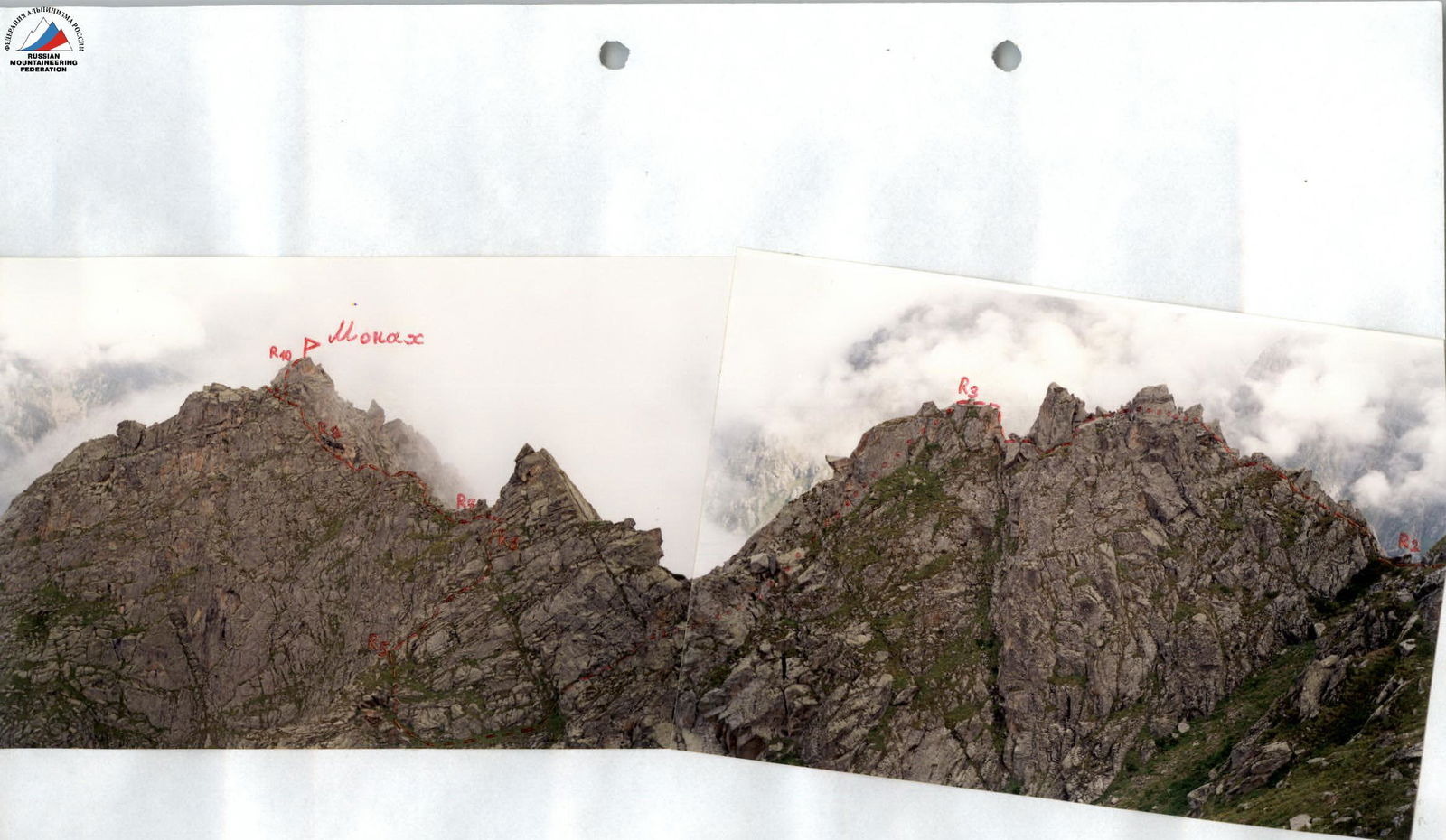
Photopanorama of the area. September. The first ascent route is marked.
Route description
R0–R1: Approaching the large-block scree, we start climbing it. The ascent goes along a wide, grassy-scree slope at the bottom, bounded on the right and left by rocky walls. Moving from one scree to another, we move up towards the visible grassy isthmus ahead. Reaching it, we find ourselves on a small ridge that extends to the South from the South-West ridge of Monakh. From here, we continue to move up towards a small col in the Monakh — Kalthberg ridge. The path goes with a traverse of the grassy slope up to 50°, with rock exits — along a barely noticeable tur trail.
Attention! — the path to the col of the South-West ridge, with relative simplicity, is dangerous — below are 300-meter walls! With wet or snowy grass on the section from the isthmus to the col, insurance is necessary!
Section characteristics:
- Length from the isthmus to the col: about 150 m
- Category of complexity: up to 2
- Height gain from the start of the ascent along the Southern slopes of the Monakh-Kalthberg ridge: about 400 m
- Total length of the section: about 800 m
R1–R2: Reaching the col of the South-West ridge of Monakh peak, we bypass the top of the first gendarme along the Northern slopes. The upper part of this gendarme collapsed in July 1997 to the East, causing a massive rockfall and forming a large scree at the base of Monakh's southern walls. We return to the South-West ridge by going to the isthmus between the 1st and 2nd gendarmes, after bypassing the northern slopes of the 1st gendarme with rock exits of 1–2 category. The entire section is about 150 m. From KSP: 3–3.5 hours.
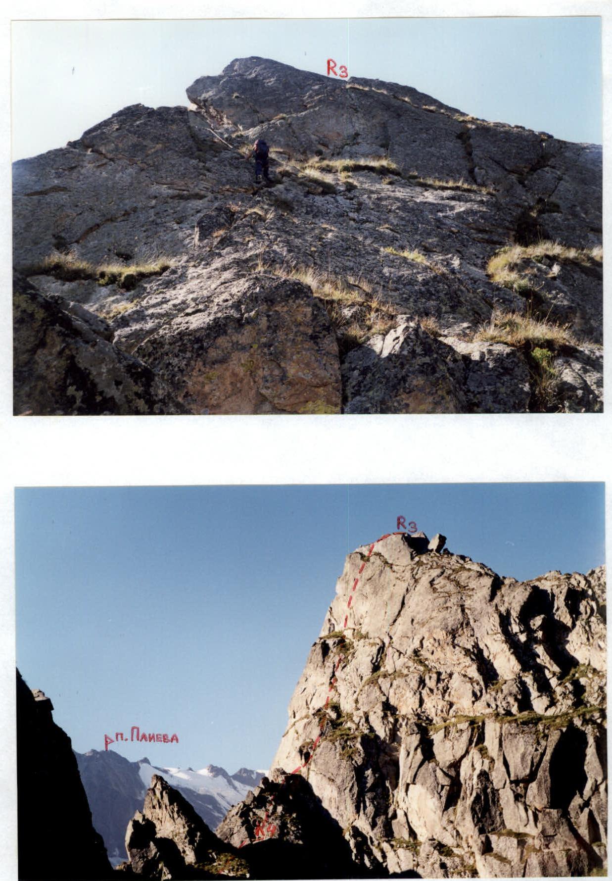
R2–R3: On the isthmus, turn left and move directly along the ridge to the top of the second gendarme. Section characteristics:
- Ridge length: 70 m.
- Category of complexity: 2–3 category.
- At the end — a 3 m wall, 4 category.
R3–R4: From the top of the 2nd gendarme, rappel 50 m towards the visible isthmus in front of the 3rd gendarme. Here, it is not recommended to pull the rope, since after Monakh peak, you will have to return here, and climbing the 2nd gendarme will require 50 m of 4–5 category rocks.
R4–R5: From the end of the rappel, a grassy shelf is visible, going left — up from the isthmus in front of the 3rd gendarme. Passing the isthmus along this shelf, we start bypassing the 3rd gendarme along its western slope. At the end of the shelf, we come to a small site on the northern edge of the 3rd gendarme. The entire section is about 100 m, 1–2 category.
R5–R6: Along the Northern edge of the 3rd gendarme, we move up towards its top — 50 m. The path goes along its right side along a wall of 50–60°. At the end — ropes to cross the edge to its left side. The entire section is 60 m, 3–4 category.
R6–R7: Not reaching the top of the 3rd gendarme, from the left side of its northern edge, it is necessary to traverse left 20 m under the rusty overhanging rocks, along good hand and foot holds. Section — 4–4+ category. Psychologically difficult place. The traverse leads to the base of the South-West ridge on a shelf from its northern side.
R7–R8: Along the shelf on the Northern side, pass about 20 m, and then exit to the ridge. Along the ridge, pass another 60 m — with a small gendarme in the middle, from which descend directly down the slab. The path of movement — directly along the ridge or along its right side. Section: first 2, then 3–4 category.
R8–R9: Pass the wall of the 4th (pre-summit) gendarme directly up — 10 m, then go left along the rocks with an exit to the Northern slopes. Along the shelves, descend about 20 m under the summit tower — to the isthmus. The entire section is about 60 m. Rocks: first 4, then 3–2 category.
R9–R10: To the top of Monakh, exit along the wall of western exposure almost immediately from the isthmus — 25 m to the end of the summit tower: 4–4+ category. Then pass another 15 m to the summit tour. The summit is an excellent panoramic point of the entire Tsey area. From KSP: about 8 hours.
Return also along the South-West ridge with rappels on sections R10–R9, R9–R8, R6–R5.
Route along the South-West ridge to Monakh peak. August. View from the spur extending to the North-West from point R1.
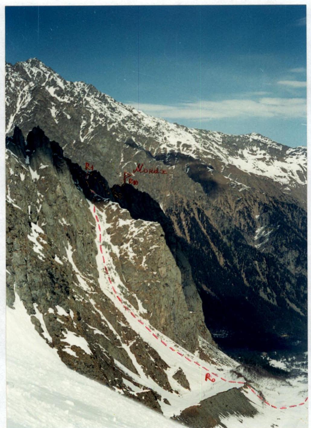
Start of the route. Path of ascent to the Monakh — Kalthberg ridge. View from South-West. February. Photo from Skaazsky glacier.
Descent from the second gendarme. Section R3–R4.
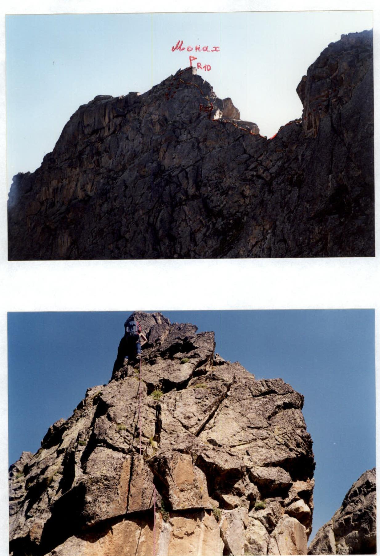
Pre-summit gendarme. Passage of the lower part of section R8–R9.

Exit to the summit tower. Section R9–R10.

Route along the South-West ridge to Monakh peak. August. Photo from the summit tour.

South-West ridge of Monakh peak. October. View from North-West. The first ascent route is marked.
Conclusions and recommendations for the route
The number and technical complexity of key sections of the South-West ridge of Monakh peak correspond to a 3A category route. But due to the low height of the peak, short approaches, etc., we recommend classifying the route as 2B.
The route can be recommended for sports teams for training and strong training groups.
The route can be taken immediately after a long period of bad weather, when other routes in the area are still snowy. It can be recommended for climbing in the off-season. The route can be taken from May to October.
It is recommended to take 50 m ropes, 2 pcs for a group of two. Expendable pitons and loops are necessary on the route.
The South-West ridge consists of strong monolithic granites. The rocks are block-type, with wide cracks. Therefore, channel-shaped pitons are necessary, and it is desirable to have large-sized chock stones with you.