Ascent Route Description to the summit of Lagau, 4064 m
From the West
Approximately 2B cat. diff.
From the lower Zaramag camps, the path lies in the direction of the glacier descending from Mt. Zaramaga. Cross two streams and then follow the trail towards the left (in the direction of travel) green moraine. In the middle, traverse the talus to the right green moraine. Up along it, under the reddish rocks. Leaving the rocks on the left, ascend to the upper camps.
The journey from the lower to the upper camps takes about 2 hours. From the upper camps, head up and to the right, towards the black moraine talus, approximately 15 minutes.
The order of movement from the upper camps:
- Turn right and ascend this talus for about 5 minutes.
- Then head towards the depression in the next black talus descending from the slopes of Mt. Adai (on the left in the direction of travel).
- Enter a wide snow-ice cirque.
From the upper camps — 30–40 minutes.
Crossing the cirque, exit onto a snowy slope turning into a wide snowy couloir leading to the false Skazsky Pass. Initially, follow the middle part of this couloir. Upon reaching the level of the hanging black rocky outcrop on the slope of the Adai-Khokh massif:
- Turn right and head towards the ridge separating the Adai-Khokh and Lagau glaciers.
- Use the light-colored rocky outcrop — a "tooth" on the ridge — as a landmark.
- Ascend the couloir to the depression in the ridge at the base of the tooth.
From the upper camps to the tooth, the journey takes 1.5–2 hours.
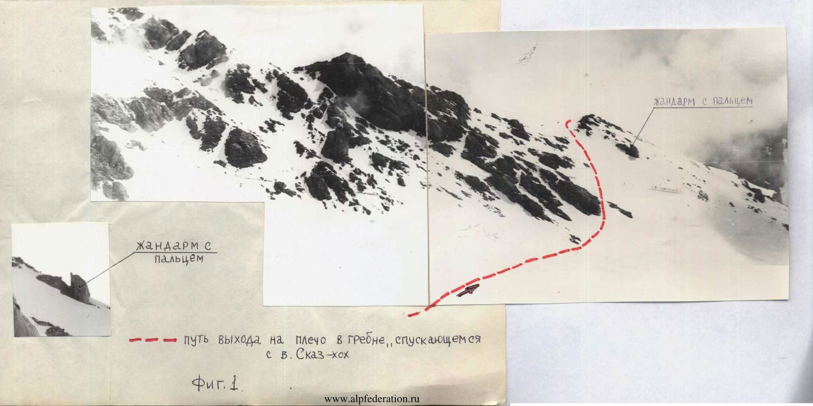
Leaving the rocky tooth on the right (in the direction of travel), descend to the other side of the ridge, 3 ropes. Head towards the ridge descending from Skaz-Khokh. Reach the shoulder of the Skaz-Khokh ridge, above the right gendarme with a finger.
The path from the base of the tooth takes about 40 minutes (Fig. 1).
Traversing the Skaz-Khokh ridge on snow and medium talus, transition into the snow-ice cirque of Mt. Lagau.
Cross the upper reaches of the Lagau glacier and head left, towards Mt. Bezymyannaya. After 40–50 minutes, behind the dark steep rocks in the massif of Mt. Lagau on the right (in the direction of travel), a snow-ice couloir opens up, widening at the bottom (Fig. 2).
With caution, keeping to the rocks on the left side, with thorough belaying, ascend this couloir, 7–8 ropes. The couloir is of medium steepness, about 40°. The couloir leads to the ridge of Mt. Lagau. The journey through the couloir takes approximately 1 hour.
Then follow the ridge, on rocks of medium and easy difficulty. The rocks are heavily deteriorated. Along the ridge, reach the summit. From the upper Zaramag camps, the journey takes 6–8 hours.
Descent:
- Along the ridge, until reaching the Lagau glacier.
- Traverse the glacier on its left part (in the direction of travel).
- From the glacier, transition to the talus, and then to the grassy slopes.
- Along the stream to the lower Zaramag camps.
From the summit to the camps, the journey takes 2–3 hours.
The route to Mt. Lagau from the west was first climbed in 1972. Repeated estimated passages of the route were made on June 16, 1971, and July 6, 1975.
First ascent group:
- Akhtyrchenko G.V., CMS — leader
- Goncharov V.D., 1st sports category
- Arefieva R.G., MS
- Benenson B.A., 1st sports category
- Kivlenev V.N., 1st sports category
The group members have climbed 8–20 routes of the 2nd category of difficulty. The group believes that the route to Mt. Lagau from the west corresponds to the 2B category of complexity.
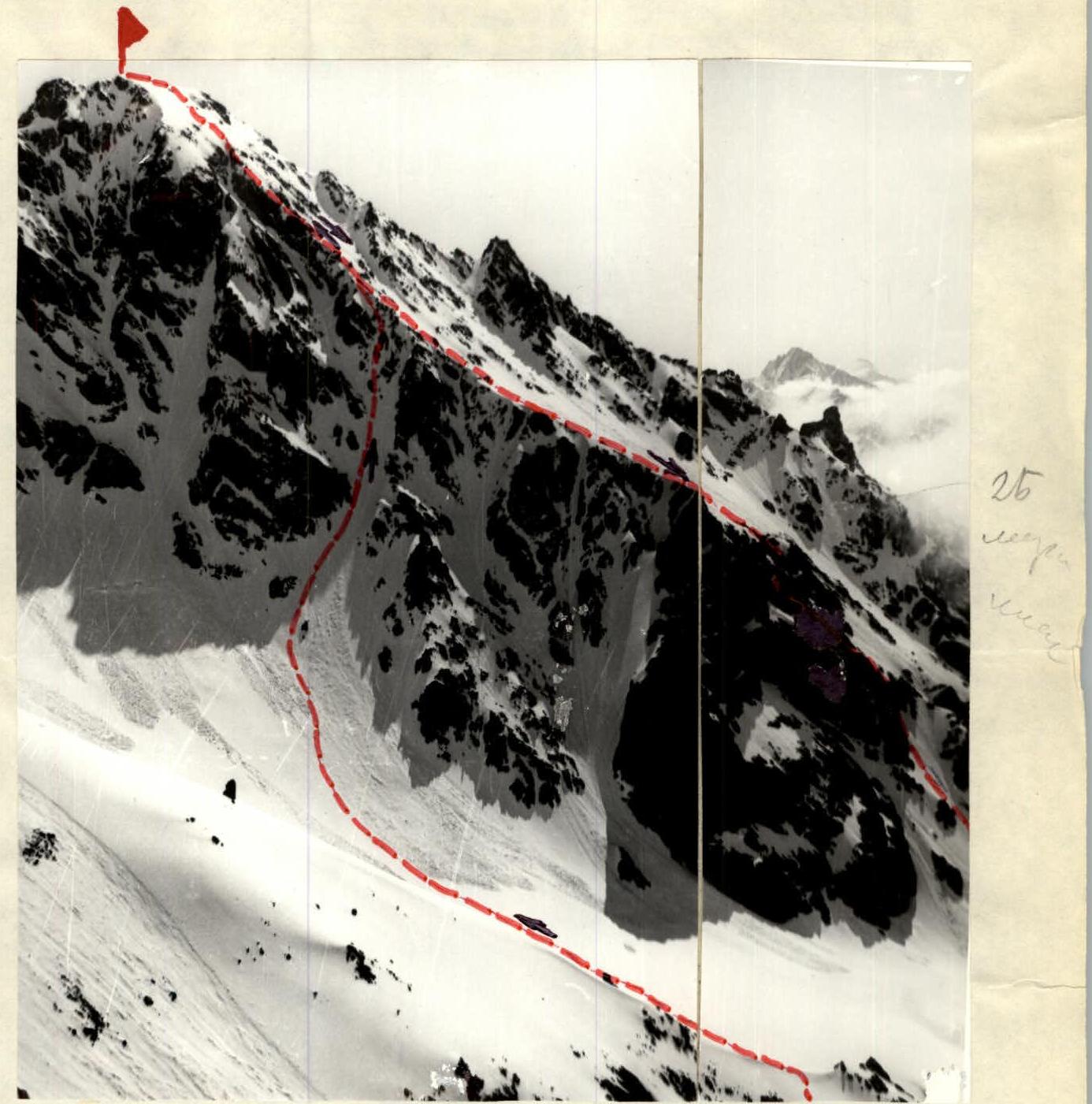 Ascent path to Mt. Lagau from the West.
Fig. 2
Ascent path to Mt. Lagau from the West.
Fig. 2