Route Description
From the sites under the buttress, along the talus shelves in the direction of the buttress with a large sharp ledge (150 m). The ascent to the buttress begins along a wide internal angle ("live" stones - belay) through rocks of medium difficulty. Further on, along simple rocks, bypassing the large sharp ledge of the buttress on the right side. Here is the control cairn. From the control cairn, traverse to the right with an exit to a small site under a 40 m slab-like wall. Along the 40-meter wall (pitons belay, key point of the route). Ascent to the buttress to a large boulder lying separately, which is bypassed on the right. Further on, along simple and medium difficulty rocks on the left side of the buttress in the direction of the "triangle" formed by the depression in the buttress. The "triangle" is bypassed on the right along simple rocks ("live" stones). Further ascent to the buttress and along rocks of medium difficulty (belays through ledges) with small walls upwards in the direction of the saddle between the buttress and the ridge of Peak Vils. On the saddle, there is a large site (there is a place for a tent). From the site upwards along the talus (there may be snow) ascent upwards and to the left (150 m) in the direction of the destroyed north-western edge of Peak Vils, representing 3 large "gendarmeries". The "gendarmeries" are bypassed on the left along simple and medium difficulty rocks on the right side of the couloir ("live" stones, belay). From the third "gendarmerie", exit along simple and medium difficulty rocks ("live" stones - belay) to a large snow site under the summit. From it, along the talus (possibly snow-ice) slope, ascent to Peak Vils. Estimated time to complete the route is 6–8 hours. Descent along the ascent path. From the large boulder lying separately on the buttress, 40 m rappel. Descent along the South ridge of Peak Vils, category 2A, is also possible.
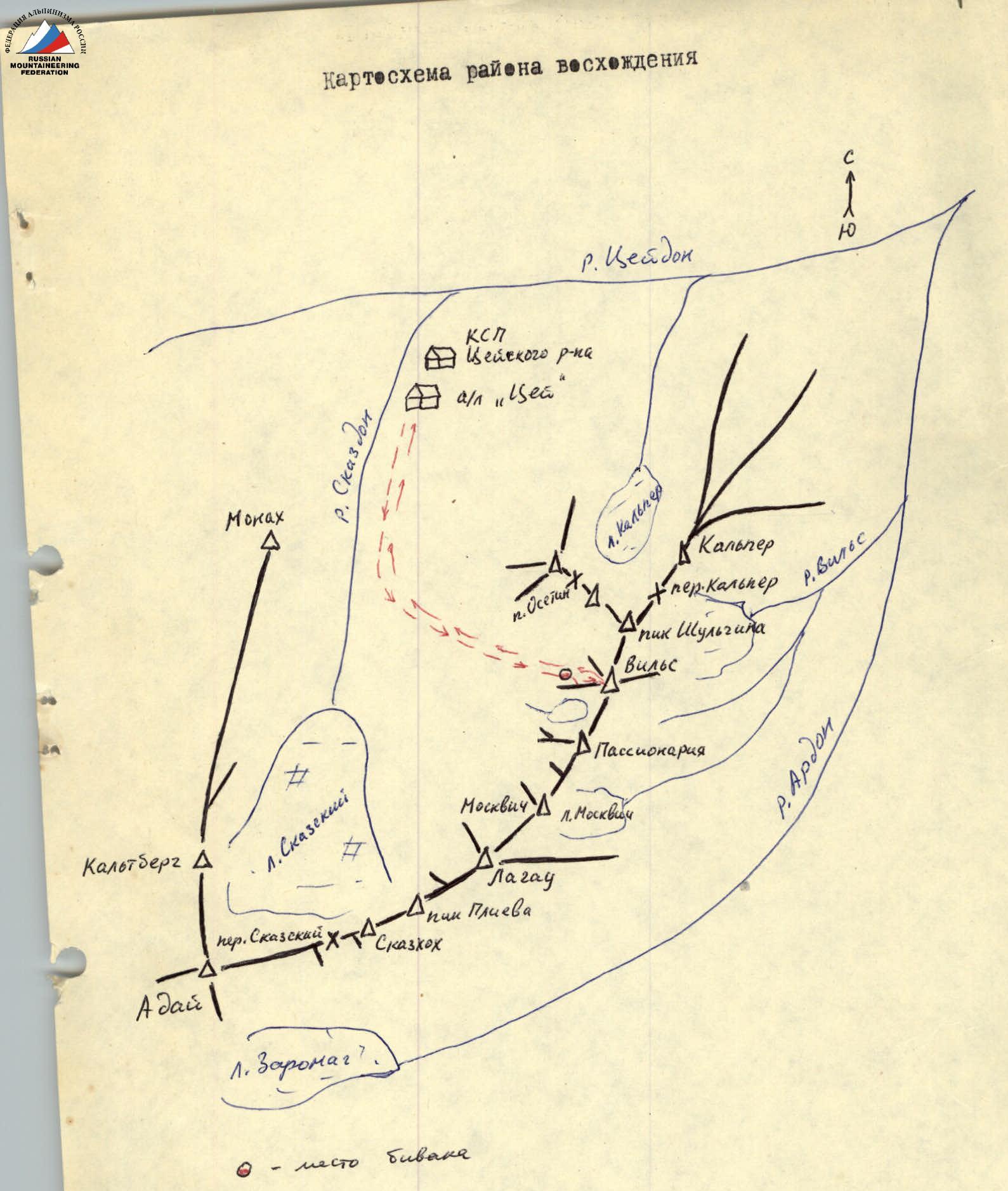
Brief Description of the Approach to the Route
From the CSP of the Tsey district, ascend along the trail of the left bank of the Skazdon River to the stream (avalanche runoff) near the green hill, flowing from the couloir on the left. The couloir descends from under the northwestern walls of Peak Vils. Here, turn left and enter the couloir. Along the right side of the talus, possibly snow-covered, couloir 600–700 m upwards, not reaching its bifurcation (rockfall possible in the couloir). On the right, on a rocky island, there are sites from the CSP of the Tsey district, 2–2.5 hours. From the sites, ascend 200 m upwards along the talus (there may be snow) and, not reaching 150 m to the couloir bifurcation, turn right. Ascending 100 m along the talus (there may be snow), cross over a small rocky ridge and, turning left, ascend 200–250 m along the talus (there may be snow) to the sites under the buttress. From the sites on the rocky island - 1–1.5 hours.
| Date | Designation | Average steepness, ° | Length, m | Nature of relief | Difficulty | Condition | Weather conditions | Rockfall | Ice | Pitons |
|---|---|---|---|---|---|---|---|---|---|---|
| July 29, 1980 | R0–R1 | 45° | 100 m | internal angle and shelves | 2 | destroyed | good | 1 | — | — |
| R1–R2 | 70° | 40 m | wall | 4 | monolith | good | 6 | — | — | |
| R2–R3 | 30° | 200 m | ridge | 2 | monolith | good | ledges | — | — | |
| R3–R4 | 45° | 200 m | ridge | 3 | destroyed | good | 1, ledges | — | — | |
| R4–R5 | 35° | 150 m | talus (possible snow) | 1 | destroyed | good | simultaneously | — | — | |
| R5–R6 | 45° | 200 m | destroyed edge | 3 | destroyed | good | ledges | — | * | |
| R6–R7 | 30° | 100 m | talus (possible snow) | 1 | destroyed | good | simultaneously | — | * |
NOTE. When descending along the ascent path on the R1–R2 section - 40 m rappel. 3 rock pitons hammered in.