
Fig. 29
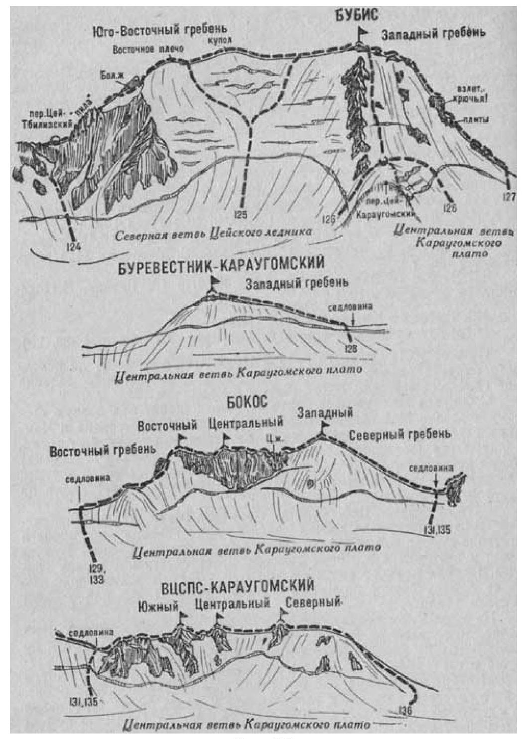
- Bubis (4428 m) via the Southeast Ridge (combined route by B. Simagin, category 3B difficulty, Fig. 29).
The path from the CSP of the Tsey region (group of 4-8 people) to the initial bivouac on the upper plateau of the Northern branch of the Tsey Glacier under the slopes of Bubis peak is described in route 83.
From the bivouac, ascend the snowy plateau of the glacier to approach the right side of the Tsey-Tbilisi Pass between Bubis peak on the right and Chanckakhi peak on the left. On the plateau, overcome the bergschrund via an avalanche gully, and ascend (possible avalanches and rockfall - piton belay) straight up the steep ice-snow slope. Then, ascend steep, broken, but straightforward rocks (key belay) to reach the Tsey-Tbilisi Pass.
The path to the Tsey-Tbilisi Pass from the Shovi resort:
- From Shovi resort, ascend a forest trail to the right slopes of the narrow canyon of the Bubis River.
- Follow the trail high above the river to approach the point where Bubis River sharply turns left and the Tbilisi River flows into it.
- Descend to the Tbilisi River.
- Proceed a short distance upstream along the right bank.
- Cross the Tbilisi River.
- Ascend along the left bank to the "Green" meadow under the tongue of the Tbilisi Glacier.
You can also reach the "Green" meadow via the left bank of the Bubis River, down to the settlement-farm (see route 83). Beyond the settlement, follow the trail upstream through the gorge, descend to the Bubis River (above the confluence with Tbilisi River) and cross it near the cow shed. From the river, ascend right-upward to a grassy spur of the South Ridge of Bubis peak. From it, descend right to the Tbilisi River and follow the bank upstream to the "Green" meadow under the tongue of the Tbilisi Glacier. From Shovi, 5-7 hours by any path.
From the "Green" meadow, ascend to the left-bank moraine of the Tbilisi Glacier, bypass it on the left to avoid the first step of the icefall, and exit onto the glacier. Move right-upward across the glacier, gradually crossing it, to approach (hidden crevasses) under the right side of the second step of the icefall, which is bypassed on the right via snowy slopes. Then, move across the glacier to the left, under the left side of the most powerful, third step of the icefall. Traverse the third step on its left side. Then, ascend along the center of the glacier. After crossing a wide ice crevasse via a bridge, exit onto the upper snowy plateau.
On the plateau (hidden crevasses), approach under the right side of the Tsey-Tbilisi Pass saddle.
On the glacier plateau, overcome the bergschrund via a snow bridge, and ascend a steep ice-snow slope, then steep, straightforward, and moderately difficult 80-100-meter rocks to reach the right side of the sharp Tsey-Tbilisi Pass saddle. On the pass, turn left and traverse along its sharp rocky ridge to a snowy area on the left side of the saddle. From the "Green" meadow, 8-12 hours.
On the pass, turn right (when ascending from the Tsey Glacier) and exit onto the southeast ridge of the Bubis massif. Follow the severely broken, straightforward rocky southeast ridge to approach under the wall of the first gendarme - "Pila" (Saw). Bypass "Pila" on the left via straightforward, moderately difficult, severely broken, and snow-covered rocks on the left side of the ridge ("live" rocks - belay).
Beyond "Pila", ascend straightforward rocks to reach the Southeast Ridge. Follow the straightforward snow-covered rocky ridge to approach under the wall of the Big (last) gendarme. Bypass the gendarme on the right with a 45-50 m descent along a steep ice-snow slope (piton belay).
Alternatively:
- Bypass half of the gendarme along rocks and ice.
- Ascend moderately difficult rocks in a wide crevice to the gendarme.
- Follow the ledges on its left side ("live" rocks - belay) to exit onto a saddle beyond it, under a steep ice-snow slope leading to the main ridge of the massif.
From the saddle, ascend 100-120 m upward along a steep ice-snow slope (piton belay). Then, follow a gently sloping snowy ridge to ascend to the Eastern shoulder of Bubis peak. From the initial bivouac, 8-10 hours.
Follow a straightforward, wide, gently sloping, and sometimes narrow, long ice-snow ridge (cornices), then straightforward broken rocks to ascend to the summit of Bubis. From the Eastern shoulder, 1.5-2 hours.
Descend via the Northeast slope or North Ridge-slope (see routes 125, 126). The duration of the route is 3 days.
Naumov A. F. Karaugom, Digoriya, Tsey (Central Caucasus). M., "Fizkultura i sport", 1976.