Ascent Passport
- Ascent category: rock climbing
- Ascent area: Caucasus, 2.8, Komidon river gorge
- Peak, route: V. BARZOND-TSAGVERI (3361 m), Eastern ridge
- Expected difficulty category: 3B category, first ascent
- Route description:
elevation gain — 360 m
route length — 760 m
section lengths:
- 3rd category — 40 m
- 4th category — 12 m
- 5th category — 55 m average steepness of the main route part — 50°
- Pitons used: rock — 7 pcs stoppers — 1 pc ice screws — none
- Climbing hours/days — 6/1
- Number of bivouacs: 1st on approach 2nd on descent bivouac at one location
- Leader: Levkovsky Yuri Vasilievich — 1st category
Team members:
- Rodionov Sergey Vladimirovich — 3rd category
- Stadeev Nikolay Grigorievich — 3rd category
- Salikov Sergey Vladimirovich — 3rd category
- Salnikov Sergey — 3rd category
- Porokhnevich Yuri — 3rd category
- Coach: Gudenko Vladimir Pavlovich — Candidate Master of Sports
- Departure to the route — April 20, 1996 return to bivouac — April 20, 1996
- Organization: FSO-A (Federation of Alpinism of North Ossetia-Alania)
Brief Overview of the Ascent Area
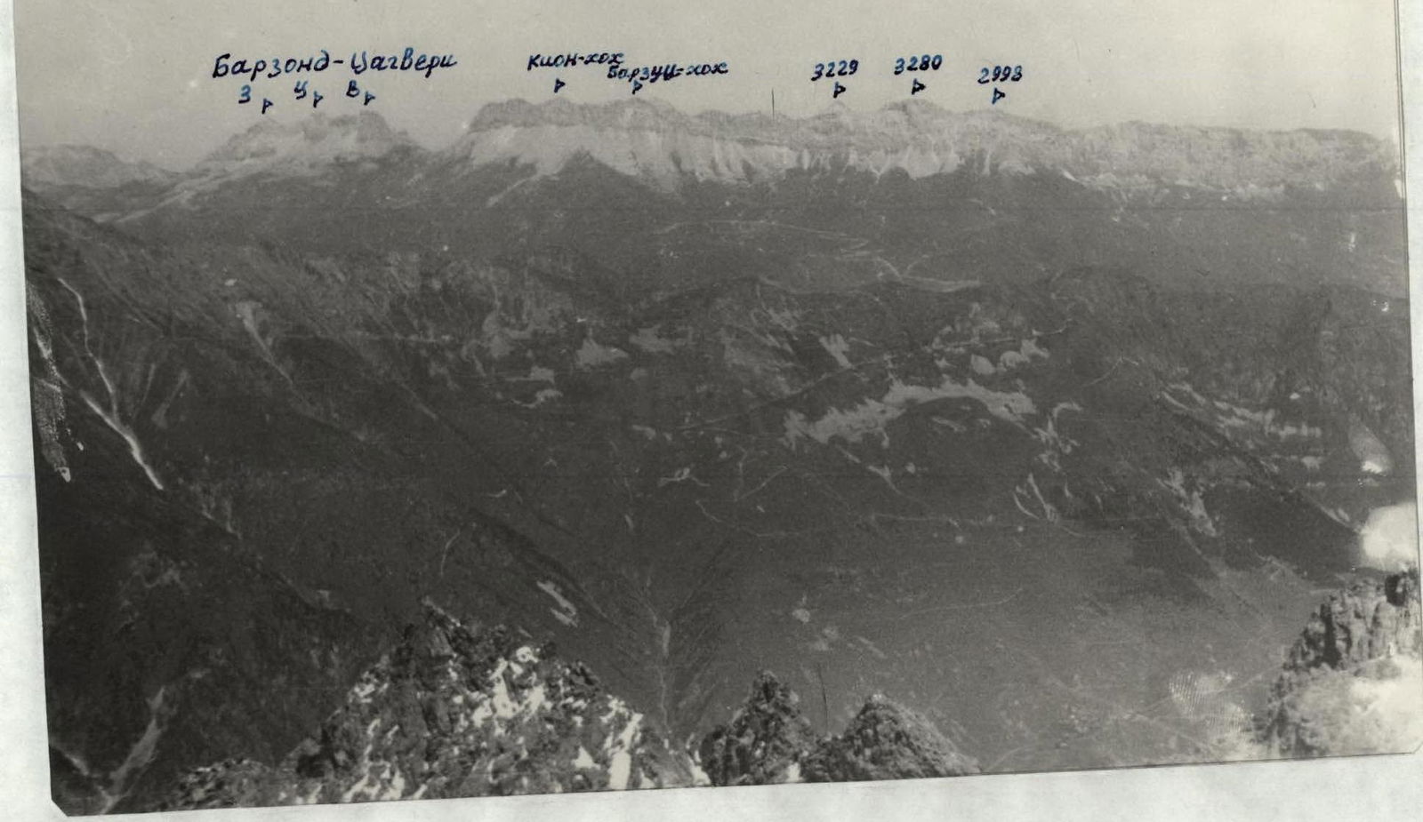
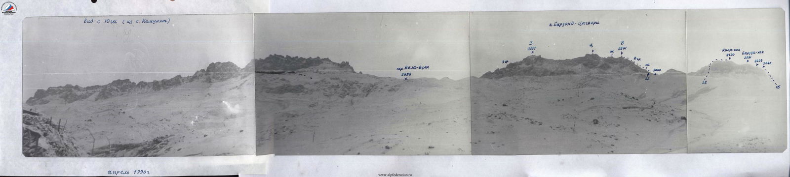
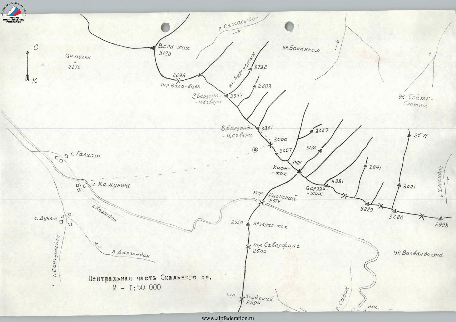
The Rocky Ridge is situated within the Republic of North Ossetia, between the Ardon River to the East and the Urukh River to the West, with its highest peak being Kion-khokh (3421 m) in its central part. The entire Rocky Ridge stretches in a latitudinal direction for 30 km. Its most interesting section for sports is the central part — from Vala-khokh peak (3128 m) to Khovtsek peak (3075 m), spanning 12 km. Numerous streams flow from the northern slopes of the Rocky Ridge, giving rise to rivers such as Tsrau-don, Urs-don, Dur-Dur, and others. The southern side has the most streams during the winter-spring period. The northern slopes of the ridge are long, heavily dissected by canyons, and have many ridges, with the upper parts formed by destroyed limestones, and the middle and lower parts covered with grass and forest on the northern side, making them difficult to traverse. The southern slopes are rocky, steep, and drier, with elevation drops of up to 400 m. The rocks forming the Rocky Ridge are of sedimentary origin: limestones, dolomites, and marbles in some places. The southern side has many scree slopes in the upper part, and grassy slopes below. Along this side, a road runs along the entire massif, connecting villages: Verkhny Zgid and Dunta, Kamunta through the Kion Pass (2514 m), from which approaches to the peaks of the Rocky Ridge are possible. Previously, this area was more explored by tourists who traversed routes through passes: VALA-vtsek, Khodsky, and others. Alpinist ascents to the ridge's peaks were practically non-existent, and there were no classified routes. Only since 1995 has the area begun to be explored by North Ossetian alpinists due to the convenience of ascending peaks during the winter-spring period. A group led by Egorin S. completed routes of 1st-2nd category difficulty on Kion-khokh peak and "3280" peak. The massif of the three BARZOND-TSAGVERI peaks stretches from northwest from the Vala-vtsek Pass to the southeast towards the saddle before Kion-khokh peak for 1.5 km and consists of peaks: Western BARZOND-TSAGVERI (3337 m), Central BARZOND-TSAGVERI (height unknown), and Eastern BARZOND-TSAGVERI (3361 m). The peaks are tower-like, rising above the ridge by up to 60 m. The ridges have many gendarmes, walls, all composed of limestone rocks. The southern walls of the massif are steep, heavily destroyed. Four large, long ridges with many gendarmes extend to the north.
Route Description
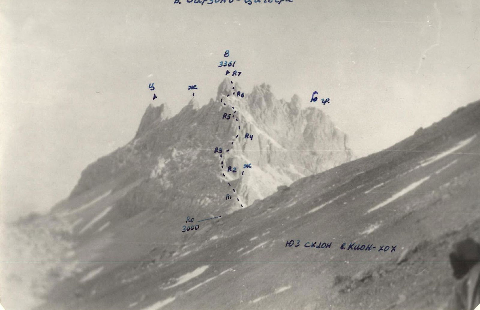
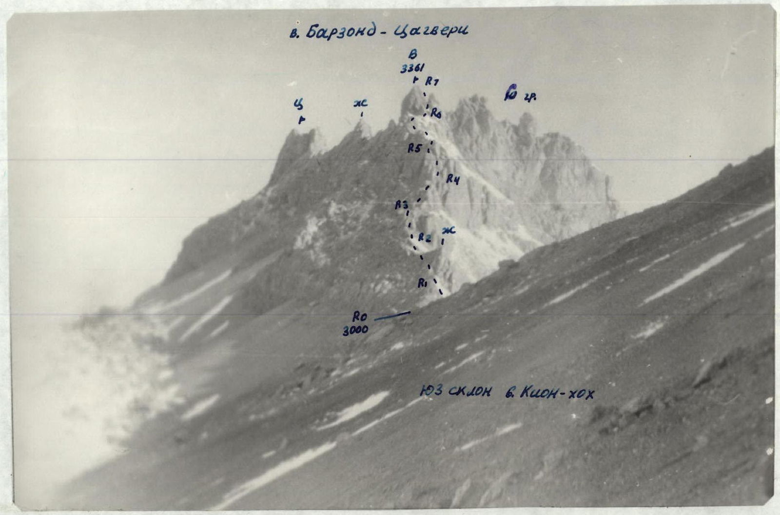
From the bivouac, move straight up the scree slopes and exit onto the saddle (3000 m) between V. Barzond-Tsagveri peak and Kion-khokh peak. Turn left, ascend a gentle scree slope to the start of the Eastern ridge of V. Barzond-Tsagveri peak — 20 minutes: section R0–R1. Continue on simple and gentle rocks, bypassing a large red gendarme on the left via a traverse, to a wide wall with three chimneys located close to each other. Ascend the middle chimney of 4th category difficulty: 60°, 12 m: section R2–R3, with good holds and piton protection, and exit onto a wide ledge. Move left along the ledge, around the corner of the rock, and ascend rocks of 3rd category difficulty onto the ridge. Follow the ridge's rocks of 2nd category difficulty for 150–180 m to approach the 1st key section of the route — a sheer wall with a series of chimneys. Under the overhanging corner to the right (above a large rock cut) is a good belay point. Section R4–R5. Turn left, ascend a chimney-couloir with a steepness of 50°: 8 m: 3rd category difficulty, between a large forked rock and the main wall, to approach the start of a vertical chimney with three "corks": 5+, 80°, 25 m. The two lower "corks" are passed with free climbing and piton protection, the upper "cork" forms a small overhang, possibly using an ITO ( artificial aid) piton with a loop. After the chimney, exit onto a wide rock ledge, move right around the corner of the rock, and continue ascending steep but simple rocks of 2nd-3rd category difficulty onto the ridge. Follow the simple rocks of the ridge of 2nd category difficulty to approach the base of the summit tower, which is bypassed on the right, and via a rock-scree couloir, exit onto the saddle between the summit tower on the left and a large gendarme on the right. The summit tower is the 2nd key section R6–R7. It is composed of heavily destroyed limestone. Ascend the wall of 5th category difficulty: 70°, 30 m, with a small number of holds and extremely destroyed rock, to reach the summit of V. Barzond-Tsagveri (3361 m). From the 3000 m saddle — 5–6 hours. Descent follows the ascent route.
View from the South
V. Barzond-Tsagveri
View from the East
View from the South (from Kamunta village)
Key Section
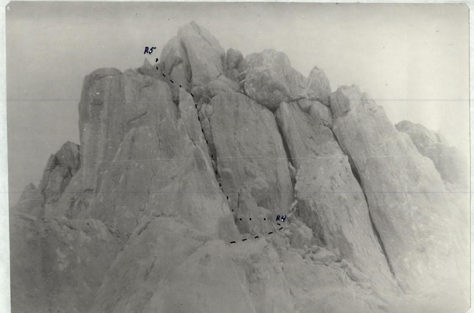
View from the East of V. V. Barzond-Tsagveri (3361 m)
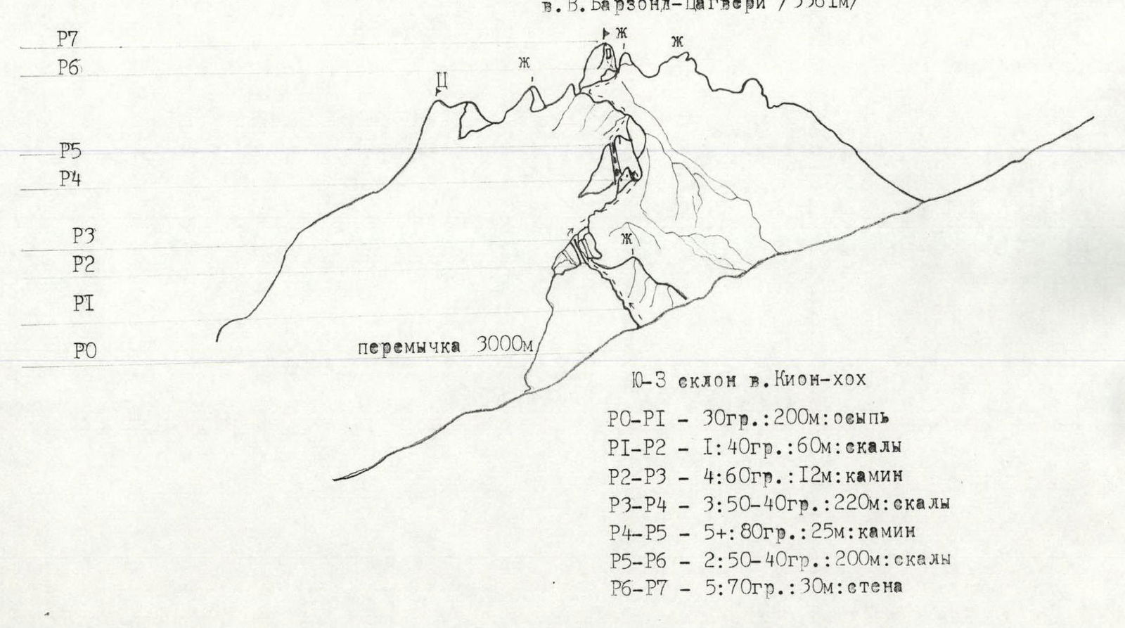
Route Diagram
View from the East V. Barzond-Tsagveri (3361 m) Southwestern slope of Kion-khokh peak R0–R1 — 30°, 200 m: scree R1–R2 — 1: 40°, 60 m: rocks R2–R3 — 4: 60°, 12 m: chimney R3–R4 — 3: 50–40°, 220 m: rocks R4–R5 — 5+: 80°, 25 m: chimney R5–R6 — 2: 50–40°, 200 m: rocks R6–R7 — 5: 70°, 30 m: wall
Central Part of the Rocky Ridge
Scale — 1:50 000