Mountainous region of Digoria, Karagoma and Tsey
Chashmura
Peak Bezymyannaya–I (3700 m)
Ascent via the Western ridge from the Southern branch of the Tanatseti peak
Group composition:
- Kononova E.P. — team leader, Candidate for Master of Sports
- Grishkevich A.I. — participant, Candidate for Master of Sports
- Vasilenko V.N. — participant, 1st sports category
- Baranenko V.D. — participant, 3rd sports category
Climbing report
Geographical description of the ascent area
The mountainous region of Digoria, Karagoma and Tsey is situated in the eastern part of the Central Caucasus, between the valleys of the rivers:
- Karasu and Cherek-Balkarsky — to the west,
- Rioni and its tributary Chancha hina — to the south,
- Mamison, Zaromag and Ardon — to the east,
- Tseidon, Sanguti, Uruh, Belyachi, Haznidon, Psygansu, Rtsyvashka — to the north.
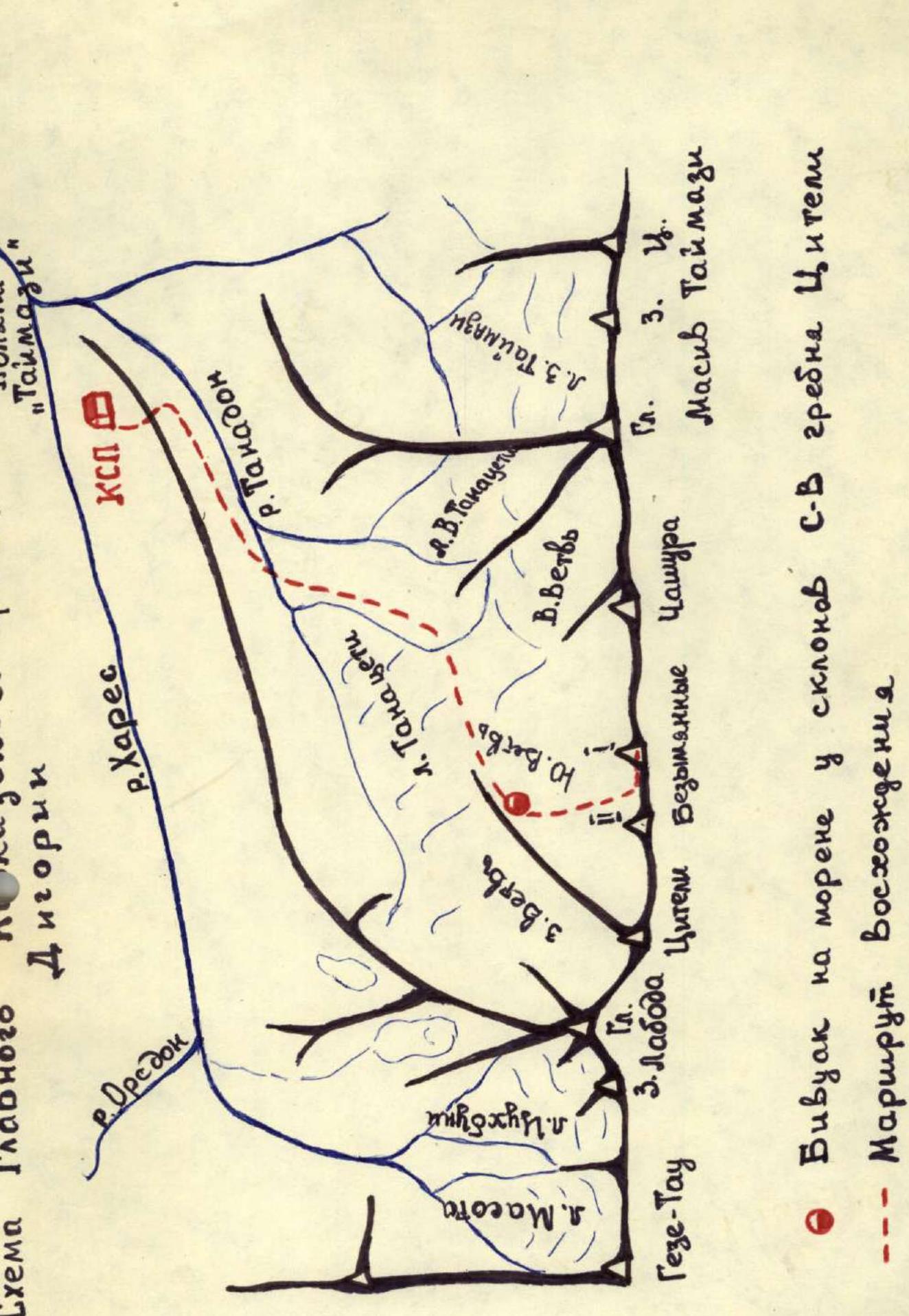
The region includes the Main Caucasian Range from Geze-Tau to Gebe in the west and the Suchansky ridge to the north of it. The ridges are connected by a ridge-saddle — Shtulu — between the peaks Geze-Tau and Suchan-Tau. To the west of the saddle lies the Karasu river valley, and to the east — Digoria, which is divided by the North-Eastern spur of peak Laboda into the northern gorge — Tanadon — and the southern — Hares. The Digoria valley begins at the confluence of Hares and Karagom and stretches southwest.
The peaks of the Main Caucasian Range in Digoria, including peak Bezymyannaya–II, between the nodal peaks Geze-Tau in the west and Gebe in the east, rise above the Hares river valley to the north and the upper Rioni river valley to the south.
East of Geze-Tau, the Laboda massif rises in the ridge. A long spur runs northeast along the entire Digoria valley, ending in a small peak Kubus. Behind Laboda, the Citel peak is located in the ridge, and to the east of it — peaks Bezymyannaya–II and Bezymyannaya–I. Further east lies peak Chashura. Next comes a section of the ridge that includes 4 peaks of the Tajmaz massif. East of the Eastern Tajmaz peak, the last peak of Digoria — Gebe — stands in the Main ridge.
Description of climbing conditions in the Digoria region, approach to the start of the route
Climbing in Digoria is done from the "Digoria" branch of the "Torpedo" tourist center. A good road leads to the meadow on the right bank of the Hares, where the Control and Rescue Station (CRS) of the Digor region is located. Not far beyond the last village — Kussu, where Tanadon flows into Hares — lies a large meadow "Tajmaz". To the south, above the meadow, rises the cirque of the Tajmaz glacier, formed by the ridges of the same name in the Main ridge. From the "Tajmaz" meadow, the Digor gorge narrows into a canyon to the west. Before entering the canyon, immediately behind the Kubus peak, is the CRS of the Digor region.
Both gorges of the Digor valley, the southern — Hares — and the northern — Tanadon — are very long and practically do not gain height throughout their length. The right and left sides of the gorges are very steep, grassy or rocky-glacial-snowy slopes. This is especially pronounced in the Tanadon gorge, whose left side is almost entirely a sheer rock wall with hanging glaciers.
Due to this relief, climbing in Digoria is challenging, as the long approaches from the CRS meadow are very steep, grassy or scree slopes in their final part, resulting in time-consuming and physically demanding approaches.
Peaks Bezymyannaya–I and –II, on which the first ascents were made, rise above the Southern branch of the Tanatseti peak, whose tongue hangs over the left (in the direction of movement) wall of the Tanadon gorge.
To reach the start of the route, one must move from the CRS hut left-upwards to the saddle in the North-Eastern spur of Laboda, to the right of Kubus. Descending from the saddle, we enter the Tanadon gorge. Further along the right bank of the Tanadon river, up the gorge, almost to the tongue of the Tanatseti glacier. Here, cross the river via a snow bridge to the left bank, and move left-upwards over scree and moraines to a sharp, steeply rising moraine. Along the narrow moraine ridge, we reach grassy ledges alternating with short rock walls resembling "ram's foreheads". Pass these, gradually moving left, and after 400–500 m, reach the right-bank moraine of the Southern branch of the Tanatseti glacier. Move along it for another 300–400 m, and at its end, near the slopes of the North-Eastern ridge of peak Citel, are convenient bivouac sites.
From the Digoria CRS — 5–6 hours.
The path described above to the upper plateau of the Tanatseti glacier — including its Southern and Eastern branches — is the only explored and safe route.