Ascent Passport
- Rock class.
- Caucasus. Digoria, Rocky ridge, section number in KMGV 2.6.
- Uazakhoh (3529 m), via the Eastern ridge and the Northern wall of the tower.
- 1B category of difficulty, first ascent.
- Height difference of the route 530 m, route length about 1 km. Average steepness of the route 30°.
- Driven pitons: 2/0; закладок 3/0. Left on the route rock anchors — 2, for descent.
- Team's walking hours – 6 hours, days – 1.
- Comfortable overnight stay.
- Team leader: Egorin S.V. – CMS.
Participants:
- Abisalov A.D. – 3rd sports rank.
- Afanasyev I.O.-S. – MS.
- Bezyaev V.V. – 3rd sports rank.
- Bondarenko I.O. – CMS.
- Vagilov A.P. – 3rd sports rank.
- Salnikov S.A. – 3rd sports rank.
- Sushko A.P. – MS. All from Vladikavkaz.
- Coach: Korablin B.N. – MS.
- Departure to the route: May 12, 1996. Summit: May 12, 1996. Return: May 12, 1996.
- Organization: SORPSS EMERCOM of Russia.
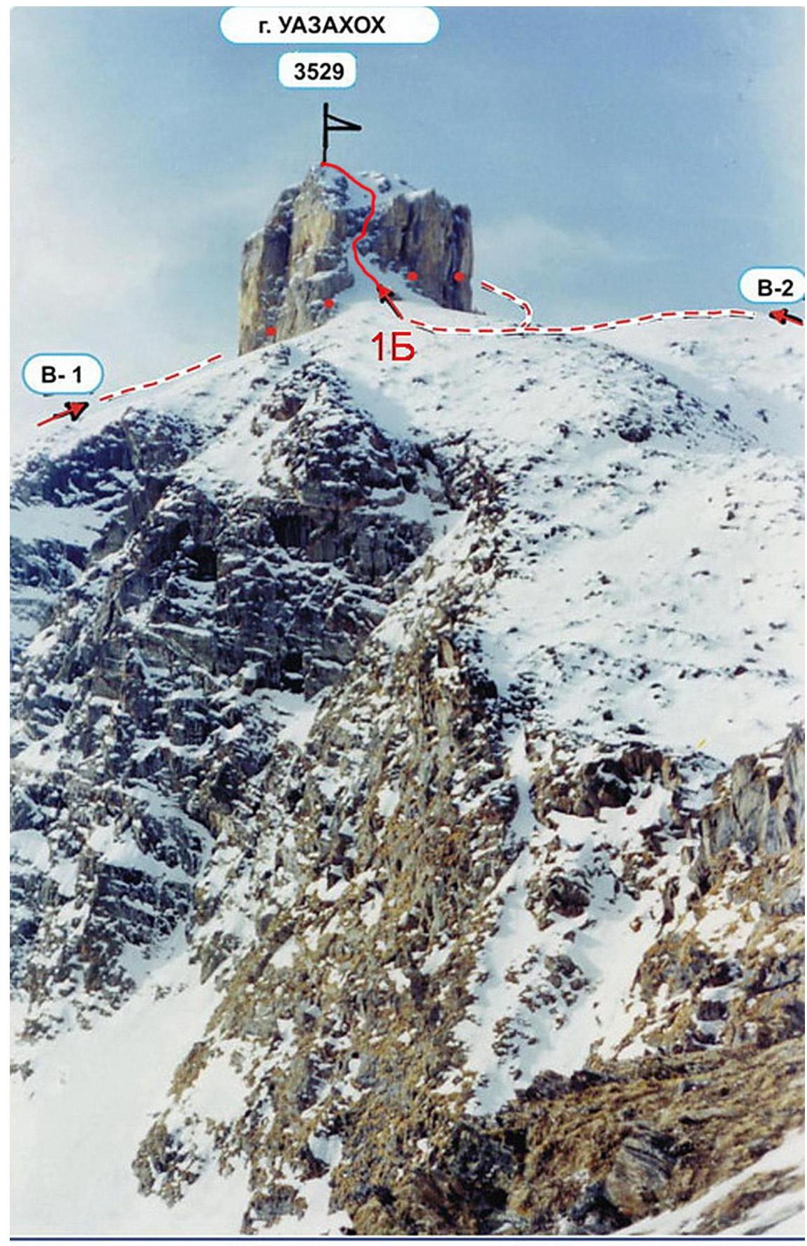
Mount Uazakhoh from the North.
Description of approaches to the route
From Vladikavkaz through the village Chikola to the turnoff to Donifars by car or bus about 100 km. From the fork starts a dirt road. From the turnoff on foot on this road (or by car) ascend towards the village Donifars – the only inhabited village in the ascent area. Having passed through Donifars, we go further up the road towards the visible ahead peak Uazakhoh (3529 m). The path goes West through numerous ascents and serpentines on grassy slopes. Having passed by a sheepfold, reach the old geological mine. To the sheepfold you can drive by a high-clearance vehicle from May to October. To the West is visible the Meshchena massif and the peak Uazakhoh. The height here is 2300 m, to this place from the turnoff to Donifars from the Chikola - Dzinaga highway about 6–7 hours. Water in the springs on the Southern slopes. Or snow from November to May.
Description of the route by sections
From the old geological mine (overnight stay here) move further West towards the visible ahead peak Uazakhoh. Having reached the grassy southern ridge of Meshchena Vost., go towards the saddle between peak Uazakhoh on the left and the Meshchena massif on the right. The path goes to the old destroyed geological road with a gradual gain in height. In 1.5–2 hours reach the saddle of the East Uazsky pass (3000 m; n. k.). R0–R1: At the saddle turn left and start the ascent along the Eastern ridge of Uazakhoh. The ascent goes first along the grassy ridge with rock outcrops, then along the rocky ridge composed of destroyed granites. Rocks 1–2, all walls are bypassed along the shelves. Along the Eastern ridge we approach the base of the Uazakhoh tower, it is composed of limestones. The entire path from the pass is about 700 m. R1–R2: The summit tower of Uazakhoh is bypassed first from the South, then from the West along the scree and scree shelves. Further we come under the Northern wall of the tower – here is snow in the off-season and in winter. The entire path is about 200 m. 1–2. R2–R3: Along the snowy slope approach the wall – a chimney in the Northern wall of the summit tower. Along the snowy or icy chimney 3–3+ (crampons) or along the wall to the left of the chimney 4 exit to the top of the wall. Here are snowy rocks like sheep's foreheads 2–3. The entire section is 20 m. R3–R4: Above the sheep's foreheads go left-up along the snow-scree slope 1–2. In 40 m reach the small ridge north of the summit. R4–R5: Along this ridge 2 ascend to the summit of Uazakhoh (3529 m). The section is about 40 m. From the overnight stay to the summit about 6 hours. The summit is a good panoramic point. Visible to the South are the areas of Tsey, Karauhom and the Sugansky ridge. Descent along the ascent route, with rappels to the base of the tower.