Ascent Passport
I. Technical class. Combined route.
- Central Caucasus. Digoria. Main Caucasian Range.
- Tajmazi Glavnaja 3803 m. Western ridge.
- Category 3B difficulty.
- Height difference 600 m. Average steepness of sections determining the complexity of the routes is 60°. The total length of these sections is 160 m. Route length is 1150 m.
- Pitons driven for belay: rock - 10 ice - 3 placements used - 11
- Travel time - 9 hours.
- One overnight stay on a snowy ridge.
- Group leader - POGORELOV A.T. - 1st sports category
Participants:
- Shamraevskij Y.M. - 1st sports category
- Dobrokvashin S.S. - 1st sports category
- Petrakov E.E. - 1st sports category
- Team coach Master of Sports of International Class Artsishevskij Y.Y.
- Date of departure on the route: August 23, 1980. Date of return to the camp: August 24, 1980.
Main Characteristics of the Ascent Route
Table №1
| Date | Designation | Average steepness | Length in meters | Terrain character | Difficulty | Condition | Weather conditions | Rock pitons | Ice pitons | Placements |
|---|---|---|---|---|---|---|---|---|---|---|
| August 23, 1980 | R1 | 30° | 120 | ice, snow | 3 | Overcast | 2 | |||
| R2 | 80° | 15 | wall | 4 | Monolith | 1 | 3 | |||
| R3 | 30° | 160 | ice, snow | 2 | 2 | |||||
| R4 | 30° | 100 | snow | 1 | ||||||
| R5 | 45° | 30 | couloir | 2 | Destroyed | Protrusions | ||||
| R6 | 30° | 60 | ledge | 2 | Destroyed | Protrusions | 1 | |||
| R7 | 40° | 40 | couloir | 2 | Destroyed | Protrusions | 1 | |||
| R8 | 45° | 60 | ridge | 3 | Destroyed | 1 | 1 | |||
| R9 | 40 | ridge | 3 | Monolith | Protrusions | 1 | ||||
| R10 | 150 | ridge | 1 | |||||||
| R11 | 60 | ledge | 4 | Monolith | Clear | 3 | 1 | |||
| R12 | 40 | ledge | 4 | Monolith | 2 | 2 | ||||
| R13 | 70° | 15 | wall | 4 | Monolith | 2 | 1 | |||
| R14 | 30° | 30 | ridge | 2 | Destroyed | |||||
| R15 | 30° | 60 | ledge | 2 | Destroyed | Protrusions | 1 | |||
| R16 | 65° | 30 | wall | 3 | Destroyed | 1 | ||||
| R17 | 20° | 90 | ridge | 2 | Destroyed | Protrusions |
 Time taken to pass sections:
| Sections | Time |
|---|---|
| (R0–R4) | — 3 hours |
| (R4–R7) | — 1 hour |
| (R7–R13) | — 3 hours 30 minutes |
| (R13–R17) | — 1 hour 30 minutes |
Possible overnight stays on the route:
- On the ridge shoulder (section R4)
- On the snowy ridge (section R10)
- Before the destroyed rocky ridge (section R14)
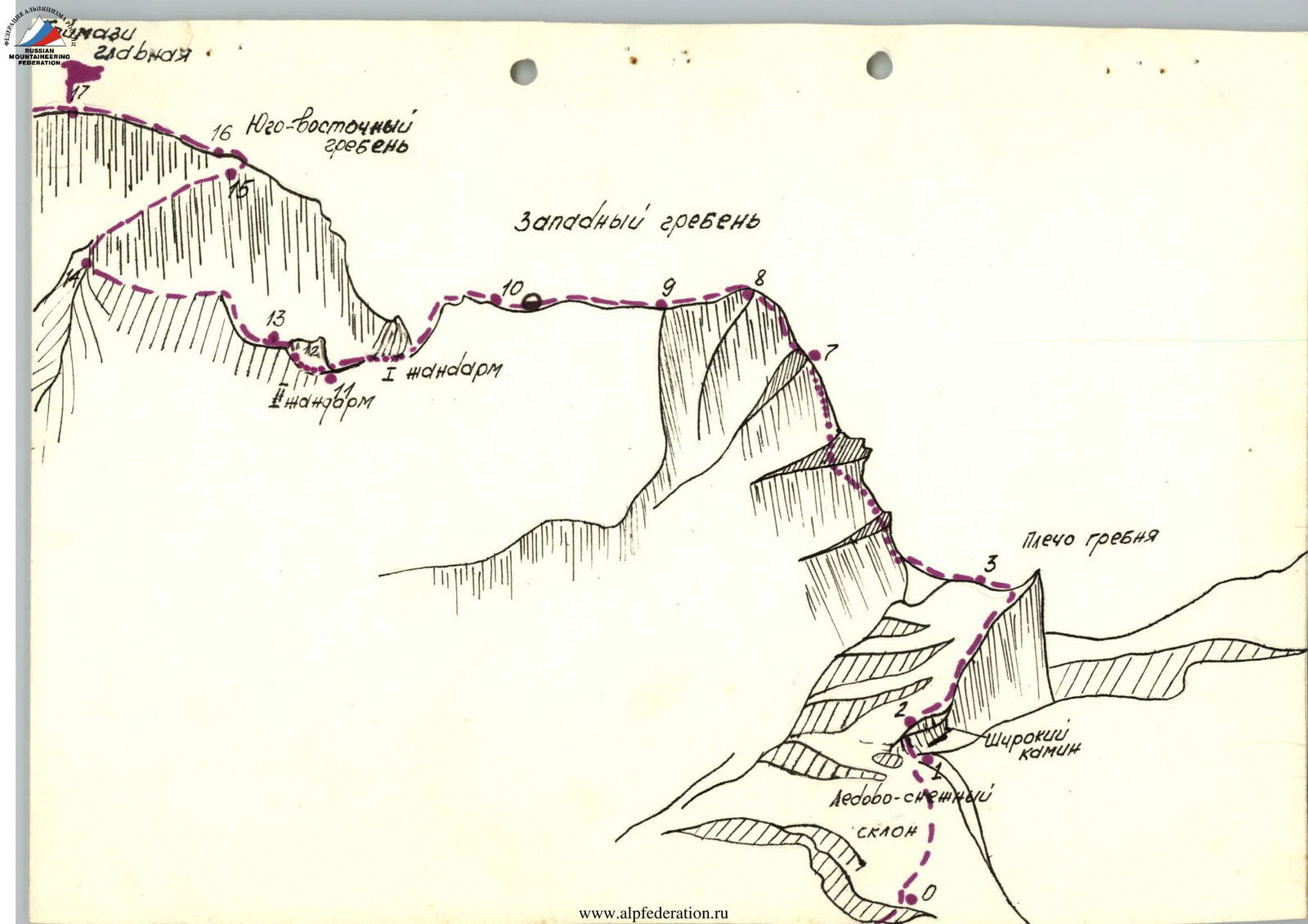
Brief description of the route
From the CSP of the Digor region, ascend to the saddle of the ridge coming from Loboda. Then, to the right, along the left bank of the Tanadon River to the bridge. Cross the Tanadon and, bypassing the western counterfort of Tajmazi Glavnaja to the right, exit to the Eastern branch of the Tanaceti glacier. A bivouac is possible on the glacier moraine. From CSP - 3 hours.
From here, ascend the glacier to the snow-ice slope leading to the ridge shoulder. Bypass the bergschrund on the left and exit to the ice-snow slope (belay). Then 120 m up the slope to the beginning of the rocky ascent in the form of a triangle (first section). Exit to the crest of the rocky ascent to the left of the wide chimney (15-20 m, rocky wall), piton belay (R2). It is possible to bypass to the left along a steep (55-60°) ice ascent. Then, along the boundary of ice and rocks, 160 m up to the ridge shoulder (R3).
From the shoulder, to the left, along a simple snowy ridge, bypassing the rocky ridge to the right, approach the couloir (R4). After crossing the bergschrund (in a snowy year, there may not be a bergschrund), enter the couloir and along its right part, along the rocks, reach its beginning, under the wall (R5). Then, to the left, up along a clearly defined wide ledge (R6). 40 m from the couloir, on the ledge, there is a control cairn. From the cairn, further along the ledge to a small couloir and along it, exit to the ridge (R7). Along the ridge, up along simple destroyed rocks (R8). Then, a small descent and further 40 m along a sharp ridge (belay) (R9). Exit to a simple snowy ridge (a bivouac is possible on the ridge). From the bivouac on the moraine - 6 hours. Along the ridge, 150 m to the descent to the gendarme (R10).
Descent 30 m rappelling into the couloir under the first gendarme. Bypass the gendarme to the right along the ledge (piton belay), exit to the saddle between the first and second gendarmes (R11). The second gendarme is also bypassed to the right, first along an indistinctly expressed ledge (R12), then along the wall (R13) (piton belay).
Then, along a simple ridge, approach under the destroyed rocky ascent. From here, to the left, up along scree rocks to the ledge (R14). Further along the ledge, to the right, up along rocks of medium difficulty (piton belay), exit to the Southeast ridge (R16). Along the ridge (80-90 m) exit to the summit (R17). From the bivouac on the moraine - 9-10 hours.
Assessing this route as category 3B difficulty, the control group proceeds from its experience of passing routes of this category in similar conditions. This route is approximately equal in difficulty to the route on Loppah South along the Western ridge-slope.