Ascent Passport
- Caucasus, Sugansky Ridge, Classification section number 2.6.
- Akritova (3768 m) – via the Southern Edge.
- Proposed 2B category of difficulty, first ascent.
- Route character — rocky.
- Route elevation gain — 410 m (from point R0).
Total route length – 490 m. Length of sections 4–5 – 32 m. Steepness of key sections – up to 95 °. Average steepness of the entire route – 45 °.
- Pitons left on the route — none.
Number of placed protection elements used on the route — 15.
- Climbing hours – 4; days – 1.
- Leader: Egorin S. V. – Master of Sports.
Participants:
- Egorin S. V. – Master of Sports
- Zhirnov D. N. – 1st sports category.
- Zagryadsky V. Yu. – 3rd sports category.
- Coach: Egorin S. V.
- Route entry: August 2, 2006.
- Organization: North Ossetian Search and Rescue Team, EMERCOM of Russia.

View from the Southwest
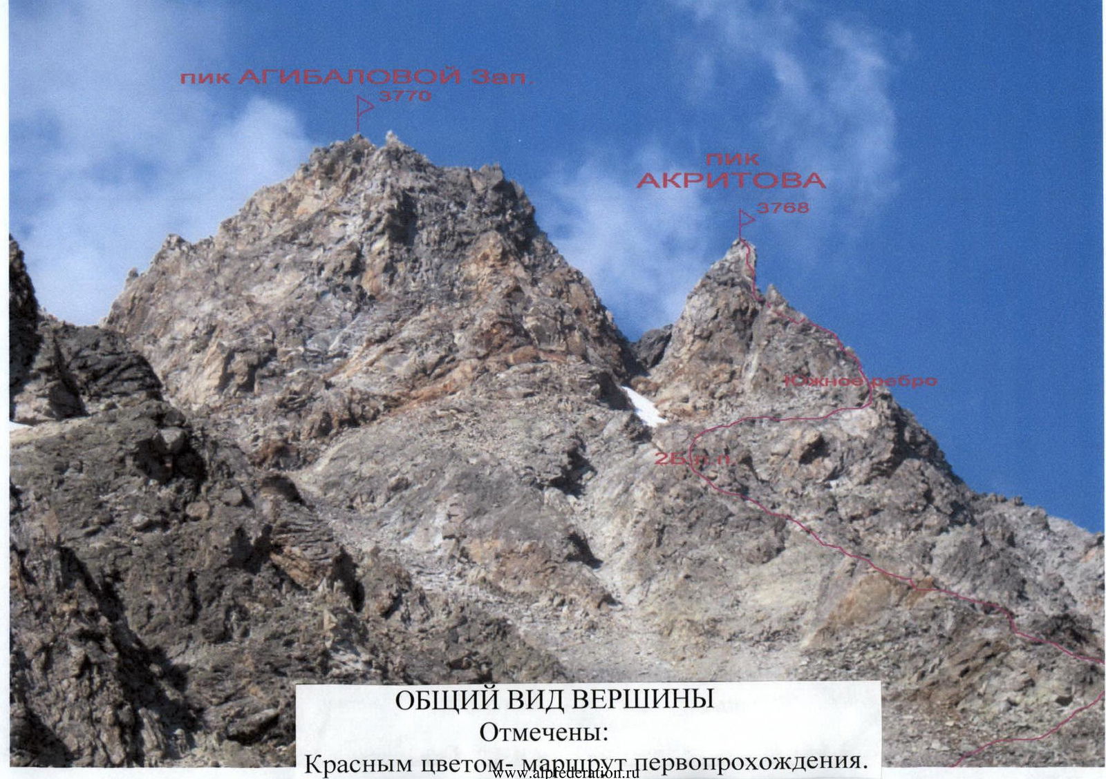
peak AGIBALOVA West 3770
peak AKRITOVA 3768
GENERAL VIEW OF THE PEAK
Marked in red: the first ascent route.
Brief Overview of the Ascent Area
The ascent was made in the Sugansky Ridge. It stretches in a latitudinal direction for almost forty kilometers. The Sugansky Ridge is located between the Cherek-Balkarsky River to the West and the Urukh (Iraf) River to the East. Its southern slopes are situated in the Republic of North Ossetia–Alania, and the northern slopes are mainly in the Kabardino-Balkar Republic.
Characteristics of the ridge:
- Average peak heights — around 4000 m
- Highest peaks — almost reach 4500 m, rising 1000 m above the snow line
- All passes, even the lowest and relatively accessible ones, are located above 3300 m
- In the central part of the ridge, passes are above 3700 m
The Sugansky Ridge is composed of ancient rocks:
- light gray granites of the Paleozoic,
- and dense, highly metamorphosed clay shales of the Lower Mesozoic.
The southern slopes of the ridge start with numerous ridges, edges, and counterforts, partially destroyed, between which are short, receding, cirque glaciers with a southern exposure. Below are numerous screes and moraines from retreated glaciers. At heights below 3000 m, alpine meadows begin with a large number of various grasses and flowers that bloom luxuriantly in summer.
The climate of the area is typical for the Caucasus — with a maximum of precipitation in the summer months and an average annual norm of 1500–1600 mm of precipitation. Summer at heights above 2500 m is short and relatively cold (average daily temperature in July–August +16 °C). Winter lasts from November to March, with frosts reaching −40 °C. There is relatively little precipitation, but after prolonged snowfalls, the approaches become avalanche-prone.
The southern slopes of the Sugansky Ridge are well освоen by climbers, who have laid dozens of routes here from 1B to 5B category of difficulty. Ascents from the North are distinguished by longer approaches and more severe conditions, so they are less frequent, and most of the northern slopes are still waiting for their pioneers.
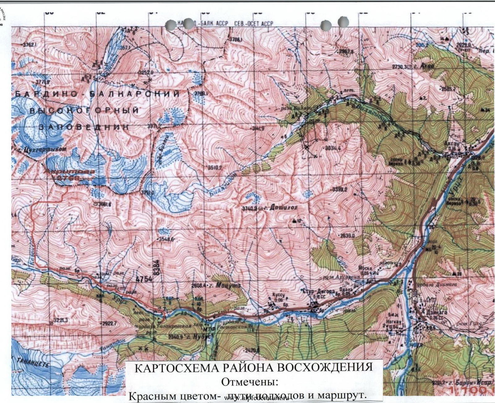
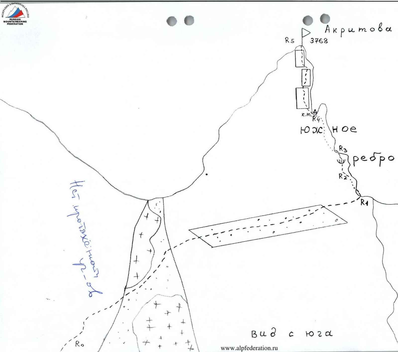
MAP SCHEME OF THE ASCENT AREA. Marked in red: approach lines and route.
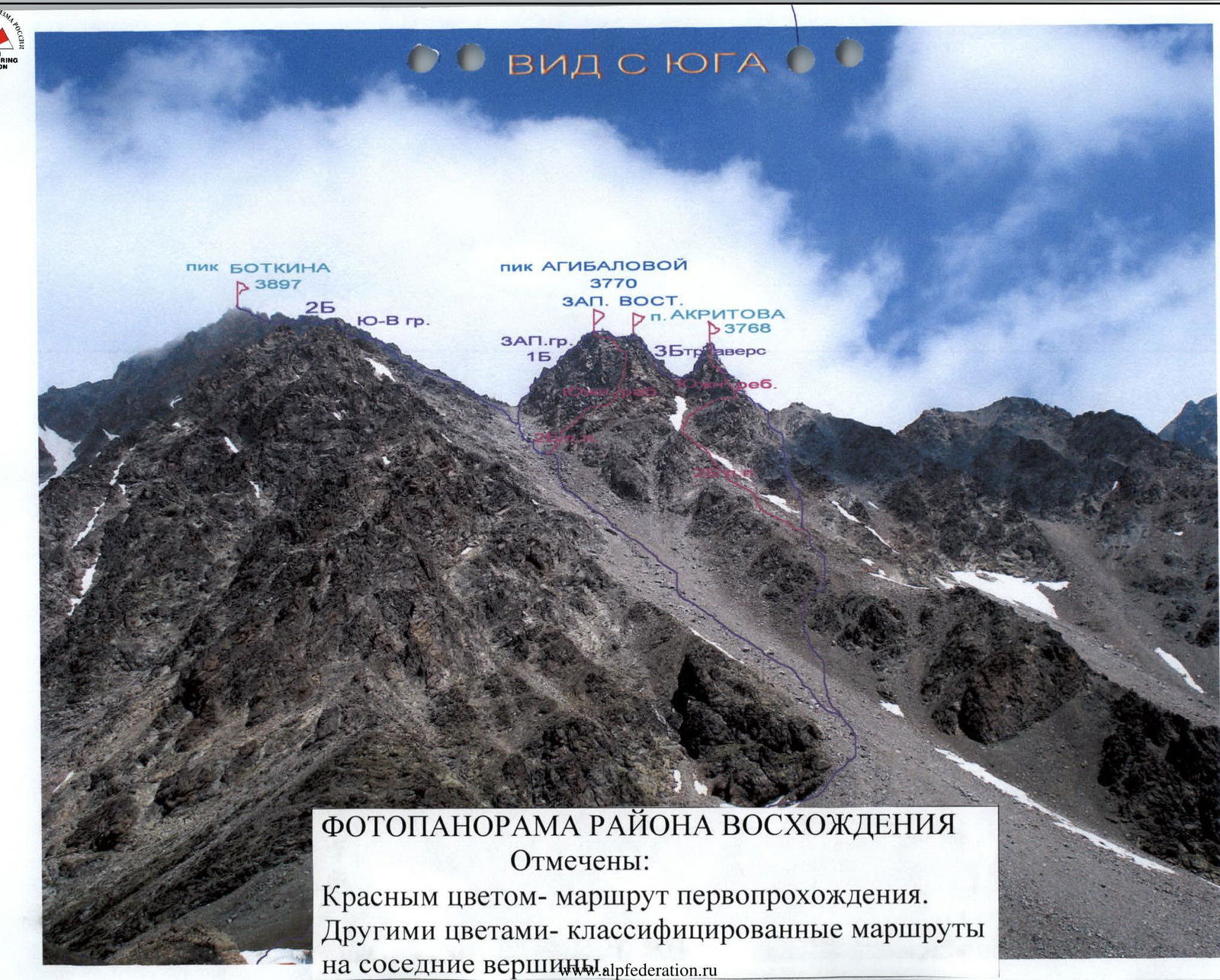
PHOTO PANORAMA OF THE ASCENT AREA. Marked in red: the first ascent route. In other colors: classified routes to neighboring peaks, nlkafederation.ru
Description of Approaches to the Route. To Galdor Campsite.
After leaving the Digoria alpine camp (Komy-Art sports and recreation camp), cross the Khares River by bridge. Then start ascending to the West up the gorge — along the trail, then along the road.
After 1 hour:
- Pass the border post (documents may be checked);
- Pass the waterfall by the road (Aykhvdon River);
- Reach the trail among the meadows.
Along this trail, crossing a couple of streams flowing from the right, 30 minutes after the waterfall, approach the fork in the trails. Continue on the upper trail, and after another 30 minutes, approach the "Agibalovka" stream, flowing from the southern slopes of the Sugansky Ridge from under the peaks of Agibalova and Akritova. After crossing this stream, turn right and continue North, starting the ascent up the wide grassy slope. The ascent path goes up to the left towards the left edge of this slope. There is a trail here, winding in serpentines between, and in places along outcrops of simple shale rocks. Caution! To the left is a steep grassy slope, dropping down to the Galdorka River. It originates from under the Galdor massif, and one of its tributaries flows through the Galdor campsite.
After the first steep ascent, the slope's steepness decreases slightly, and it narrows to a ridge, continuing with small ups and downs. When outcrops of destroyed rocks appear on the slope of this ridge to the left, start traversing left with a slight gain in height, gradually entering the Galdorka gorge. Here, in places on the slope, the trail is visible. Continue ascending along the stream, bypassing a rocky step with a small waterfall on the right. Above 3000 m, the grass on the slope becomes less, and continue on the scree slope, turning slightly to the right. To the left below, in a small gully, a stream flows — one of the tributaries of Galdorka. Continue along it until a convenient crossing over the gully appears; at this point, a white scree is visible on the slope to the right, and green areas among the jumble of rocks are visible to the left behind the stream — this is the Galdor campsite. After crossing the gully, reach the campsite under a rock with a sign. The height here is 3128 m. GPS coordinates in WGS-84 format: N 42°56.312′ latitude North and E 43°31.135′ longitude East. From the alpine camp, it takes about 6 hours on foot. Elevation gain is 1300 m.
In the second half of August, when the snowfields above melt, there may not be a stream at the campsite. Then proceed further North, towards Galdor Main, under a large scree on the slope. Before reaching it, there are more campsites and a stream.
Description of the Ascent Route
From the Galdor campsite, head East towards a small saddle in the scree ridge, which branches off to the South from the base of the southern rocks of peak Botkin. This saddle leads into the neighboring cirque under peaks Agibalova and Akritova. From the campsite, first walk along the overgrown moraine, then, after crossing the remains of an avalanche deposit, start ascending up the black fine shale scree.
Upon reaching the saddle (about half an hour from the campsite under the sign), approach the southern rocks of peak Botkin. Then traverse East under the base of the rocks. Walk along the scree slope, traversing with a slight gain in height, for 200 m.
Here, turn left and ascend up the couloir along the scree, with a steepness of 15–20 °. At the beginning of summer, there may be snow in the couloir. First, walk along its left side, then cross to the middle of the couloir. 200 m after starting the ascent up the couloir, head towards the left side of the Southern counterfort of peaks Agibalova and Akritova. To do this, cross to the right part of the couloir and start ascending to the right upwards. Upon reaching the line of the counterfort, continue along its right side.
Section R0–R1.
- Along the right side of the counterfort, on scree ledges, ascend directly upwards.
- Bypass small walls on the right along ledges and terraces, gradually approaching the couloir that begins between peak Agibalova to the left and peak Akritova to the right.
- Traverse the right part of the counterfort along the left side of this couloir, on slabs and ledges 1–2 (Caution! Do not descend into the couloir — there is a risk of rockfall).
- After 150 m, the couloir widens, and it is necessary to cross it upwards to the right, reaching the scree terrace on the left part of the Southern edge of peak Akritova.
The entire section — about 300 m, 20–40 °, 1–2.
Section R1–R2.
- Along the scree terrace, bypass the Southern edge and reach a ledge on its right (eastern) side.
- Along this ledge, proceed 20 m (1, 20 °).
- Then turn left and ascend a 20-meter wall, 60–70 °, 3 — to reach the line of the edge.
Section R2–R3.
- Along the left side of the edge, on rocks 3, 40 °, ascend 25 m to a ledge.
- From it, further, the left (western) part of the edge has a blocky structure.
- Here, it is necessary to move to the right part of the edge; for this, in the right part of the blocky rocks, through a small overhang 2 m, 95 °, 5 — reach the line of the edge.
- Further, along the right side of the edge, traverse to start bypassing the gendarme "Zub"; for this, proceed along rocks 2, another 25 m to a small ledge.
The entire section — 50 m.
Section R3–R4.
- Further, traverse another 10 m, 2, to a wall leading to the saddle of the edge, behind the gendarme "Zub".
- Along this wall directly upwards, initially a small overhang 2 m, 93 °, 5.
- The entire wall — 20 m, 70 °, 3, 4.
On the saddle — a control cairn.
Section R4–R5.
- From the control cairn directly upwards, along the Southern edge.
- The ascent path goes mainly along the left side of the edge.
- After 70 m, ascend to the summit cairn.
The entire section — 3–4, 50–60 °.
From the Galdor campsite to the summit — 5–6 hours. The summit — a good panoramic point.
Descent:
- Via the ascent route
- Or via rappels to the East (2–3 ropes), and then down to the right along the couloir to point R0, or below it.
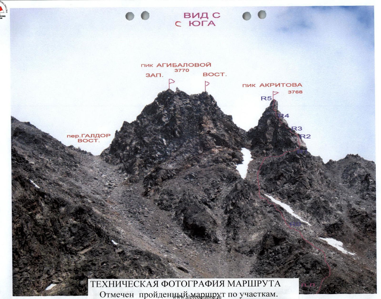
TECHNICAL PHOTOGRAPH OF THE ROUTE The route is marked by sections.
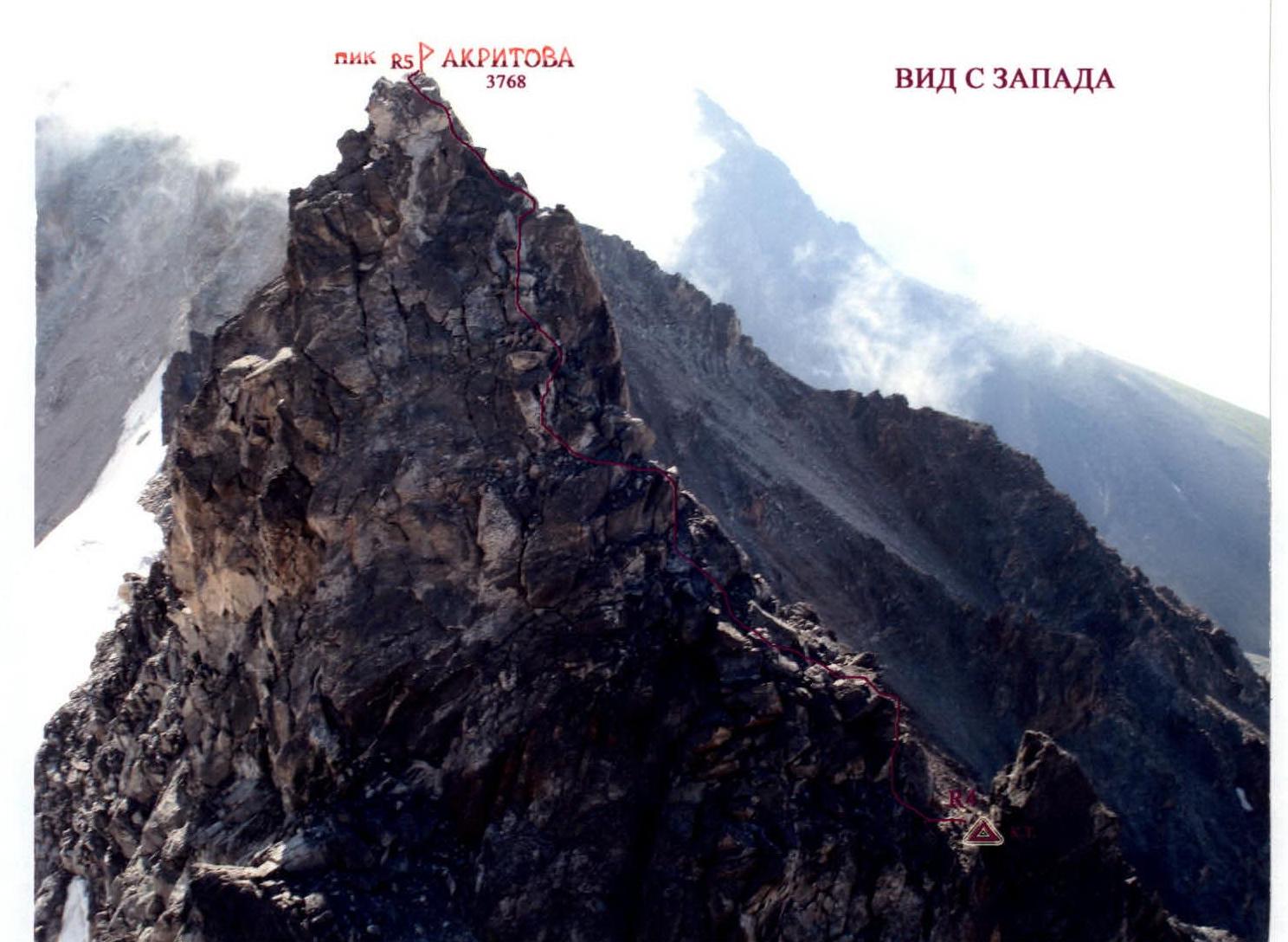
PEAK AKRITOVA 3768 VIEW FROM THE WEST PROFILE OF THE ROUTE FROM THE LEFT. UPPER PART. The route is marked.
Bul a 102a
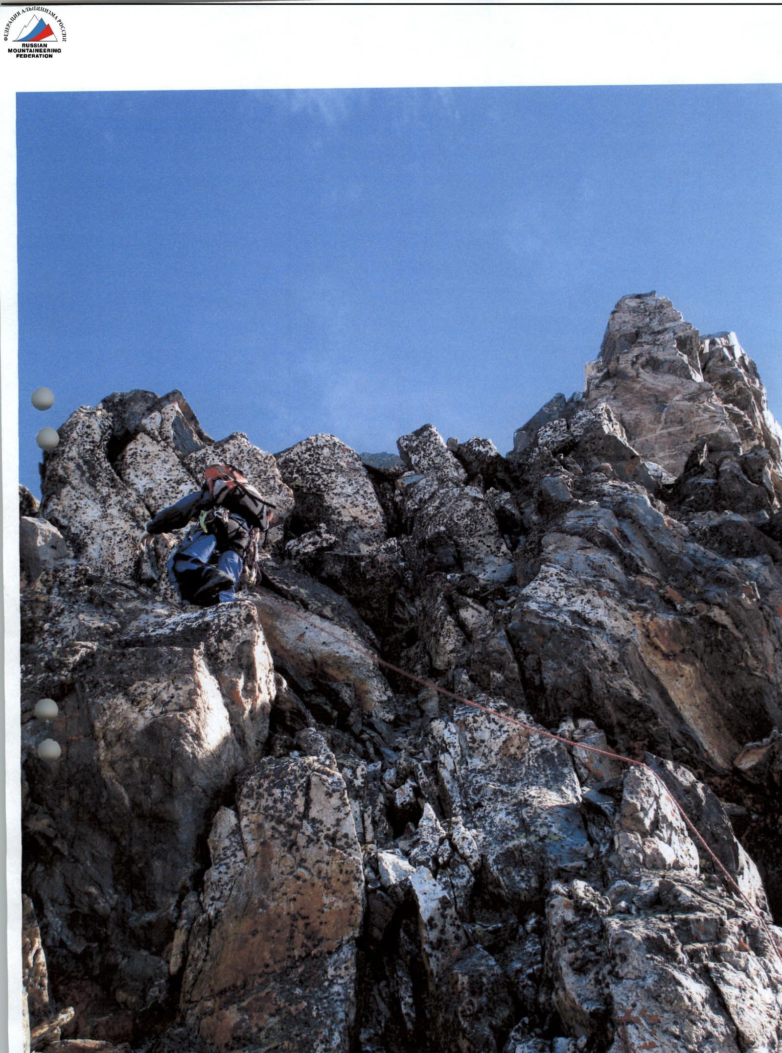
PASSAGE OF THE BEGINNING OF SECTION R4–R5
Conclusions and Recommendations for the Route
The route corresponds to the declared category of difficulty. It can be recommended for ascent by training and sports groups. Completing the route allows for practicing rope work skills. The rocks on the route are partly of a blocky type, so it is recommended to have a set of protection elements. At the beginning of summer, the couloirs may have hard snow slopes early in the morning. Therefore, it may be necessary to bring crampons on the route.
It is convenient to start the route from the Galdor campsite. The approach to the start of the route is convenient and proceeds with virtually no loss of height. When moving along scree couloirs, it is necessary to walk in a tight group to avoid dislodging stones on each other.
On the route, protection is needed on sections of 2nd category and above. On the ridge, it can be achieved:
- through numerous выступs,
- through pitons,
- as well as through protection elements.