Ascent Passport
-
Digoria, Sugansky ridge, section number according to Classification 2.6.
-
Aikhva Yuzhnaya (3731 m) – via the Northern ridge.
-
Proposed 1B category of difficulty, first ascent.
-
Route character — rocky.
-
Route height difference – 400 m (from point R0).
Total route length – about 950 m. Length of sections 4 – 5 m. Average steepness:
- key sections – 60°
- entire route – 30°
-
Hooks left on the route — none.
Number of placed chocks used on the route – 3.
-
Climbing hours – 4 hours; 1 day.
-
Leader: Egorin Sergey Vladimirovich – Master of Sports
Participant: Zhirnov Dmitry Nikolaevich – 2nd sports category.
-
Coach: Egorin Sergey Vladimirovich.
-
Approach to the route: July 4, 2004.
Summit ascent: July 4, 2004. Return to Base Camp: July 4, 2004.
-
Organization: North Ossetian Search and Rescue Team of the Ministry of Emergency Situations of Russia.

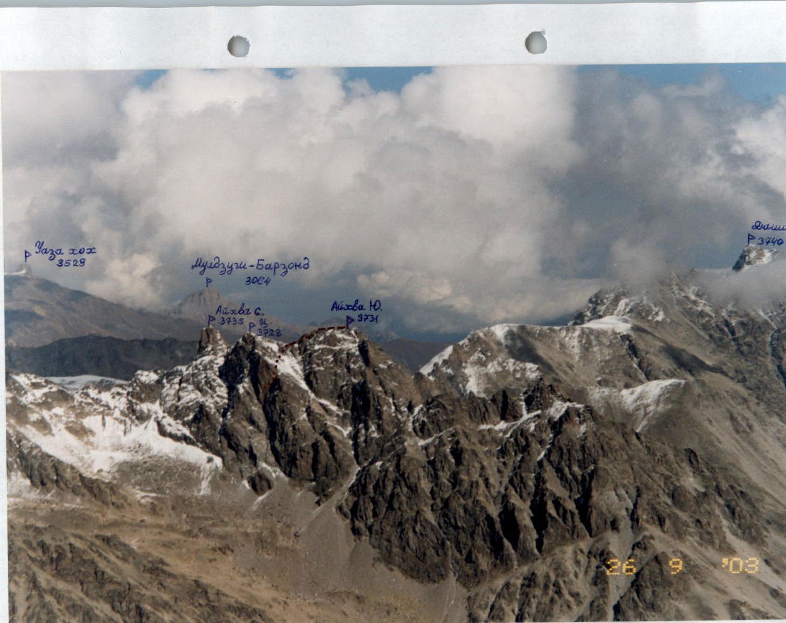
General view of Aikhva Yuzhnaya peak from the North. Photo taken from the Southern ridge of Aikhva Tsentralnaya peak. The first ascent route is marked on the Northern ridge.
Brief Overview of the Climbing Area
The ascent was made in the Eastern part of the Sugansky ridge, the Southern slopes of which are located in the Republic of North Ossetia – Alania.
The Sugansky ridge is composed mainly of magmatic rocks – granites and diorites.
In the Eastern part of the Sugansky ridge on its Southern slopes, glaciation is weakly expressed, compared to the Western part of the ridge, since the heights of the peaks in the area under consideration drop below 4000 m.
In the cirques, you can find numerous snowfields or covered remains of once large glaciers. Everywhere you can see signs of their activity:
- talus
- moraine ridges
- glacially scoured rocks
Above 3000 m, the southern slopes – especially the couloirs and cirques – are covered with numerous talus slopes, which are already starting to be overgrown with advancing vegetation in some places.
The heights of the peaks after Galdor Glavny and further East do not reach 4 km anywhere. The average height of the peaks here is 3700–3800 m. The Sugansky ridge has a mainly latitudinal direction and stretches for about 8 km from Botkin peak to Dashikhoh. Its main spurs on this section are:
- Belagsky, extending North from Aikhva Uzlovaya peak;
- Aikhvinsky spur, extending South from Aikhva Severная peak.
The Eastern part of the Sugansky ridge was rarely visited by climbers. But starting from 2000, ascents began to be made more frequently. Many new routes were climbed, and the development of the peaks in this area began.
Ascents in this part of the Sugansky ridge are optimal in the first half of summer – the snow melts quickly here, and the approaches and routes are mainly on the Southern slopes. To visit the peaks in this area, border guards do not require a permit, and the close proximity to the alpine camp is also convenient. To date, routes of 1 to 4 category of difficulty have been climbed in the Eastern part of the Sugansky ridge – and all from the South. No ascents have been made from the North so far (long approaches).
The climate in the area is, as everywhere in the Caucasus, – in summer, thunderstorms and downpours are frequent, but it is drier than on the Main Caucasian ridge. This can be seen from the sparse forests on the Southern slopes of the Sugansky ridge.


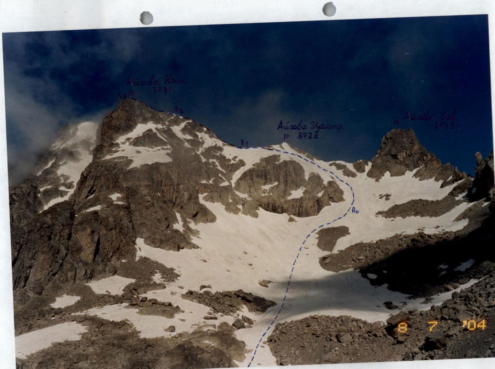
Aikhva massif from the East. The first ascent route is marked. Photo taken from the approaches.
Description of Approaches to the Route (to the Eastern Aikhvinsky Cirque)
1st option:
From the "Digoria" alpine camp (currently "Komy-Art" sports and recreation camp) ascend along the road up the Khares gorge for about an hour to the waterfall. The waterfall near the road is the Aikhvadon river, which flows out of the Western Aikhvinsky cirque, located West of the Southern Aikhvinsky spur of the Sugansky ridge.
Bypass the waterfall along the road and cross the Aikhvadon river to the right bank above it. Continue ascending towards the visible Aikhva massif. First, walk through meadows, then reach the right grassy ridge and follow it until it flattens into a wide, almost flat, grassy valley – another 1 hour 30 minutes. From here, turn right and cross the river (altitude 2700 m), then ascend to the right up the slope to a terrace with an old geological road. Initially follow the road, then use trails to continue to the right – upwards (to the East), bypassing the Southern slopes of Aikhva Malaya peak. In another 1–1.5 hours, gradually enter the lower part of the Eastern Aikhvinsky cirque.
The path goes through talus and, in the first half of summer, through snowfields. Overnight stay is possible here – altitude about 3100 m.
2nd option:
From the "Digoria" alpine camp, descend down the Khares gorge for 1.5 km (from the "Rostselmash" sports and recreation camp, ascend up the gorge for 0.5 km) to the river with a waterfall upstream – here is the water intake for the "Rostselmash" S.R.C.
To the left of the river, follow a trail upwards through the forest. 50–70 m before reaching the waterfall – turn left onto a trail that bypasses the waterfall. The trail is trodden by animals and is not clearly visible in some places.
The path upwards goes mainly along the ridge, through grass, and in some places through a pine forest. Rocks are bypassed along ledges or walls of 1–2 category. The trail is steep, and during rain, belaying may be necessary (especially during descent).
Gradually, after the forest and rocky sections end, the ridge begins to flatten, and the lower part of the Eastern Aikhvinsky cirque becomes visible ahead. Then traverse the grassy right slope and enter the cirque through talus; overnight stay is possible here, altitude about 3100 m.
Ascent from the road is about 1300 m, 3–4 hours.
The second approach option is shorter but technically more challenging and can be recommended only for strong groups.
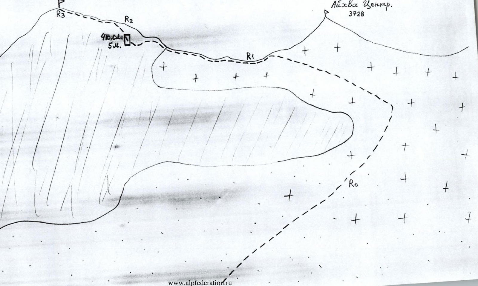
Route Description
From overnight stays in the Eastern Aikhvinsky cirque, ascend directly upwards through talus towards the saddle of the Sugansky ridge between the tower of Aikhva Severная peak on the left and Naumov peak on the right. The ascent is limited on the left by rocky outcrops of the Eastern slope of Aikhva Yuzhnaya peak – do not stray into the fog to the left, into a small cirque under Aikhva Malaya peak.
Section R0–R1:
Along a 20–30° snow-talus slope, bypass the rocky outcrops of the Eastern slope on the right. The direction of movement is under the rocky tower of Aikhva Severная peak. Before reaching it, start moving upwards to the left, above the rocky outcrops. Continue towards the saddle between Aikhva Yuzhnaya and Aikhva Tsentralnaya peaks, traversing the snowy slope and keeping to the rocks on the right. With a large amount of snow – avalanche danger!
Section is about 700 m.
Section R1–R2:
Upon reaching the saddle, turn left and begin ascending along the Northern 30° ridge of Aikhva Yuzhnaya peak.
Bypass complex sections on the left along ledges. Overcome a small wall (5 m) – category 4 – directly, and return to the ridge again.
The entire section is about 150 m – category 2–3.
Section R2–R3:
Continue along the ridge, category 2–3 (belaying using выступs) for another 100 m. Ascend to the summit of Aikhva Yuzhnaya peak (3731 m). The summit is a good panoramic viewpoint of the area.
From overnight stays to the summit for a training group takes about 4 hours. Descent is via the ascent route.
Conclusions and Recommendations for the Route
The route corresponds to the declared category of difficulty. Can be recommended for training and sports groups. For overnight stays, it is advisable to ascend with visibility, due to the complex orography of the approaches.
Water is available at overnight stays if there is snow (until mid-August).
Rocks on the route are of block type; it is advisable to have a set of chocks.
The route can realistically be completed in one day from the camp – to the camp by a strong group with a very early start.