
- Caucasus, Sugan range, classification section number — 2.6.
- Aikhva Uzlovaya (3791 m); via the South-East ridge.
- Proposed category: 1B; first ascent.
- Route type — rocky.
- Route elevation gain — 220 m (GPS). Route length is about 800 m. Steepness of key sections — up to 60°.
- Pitons left on the route — none.
- Climbing hours — 3 hours; days — 1.
- Leader: Egorin S.V. — Master of Sports. Participants: Kuracheva E.S. — 1st sports category.
- Coach: Egorin S.V.
- Departure for the route — 7:00; July 11, 2005. Summit — 10:00; July 11, 2005.
- Organization: AUSV "Digoria".
Brief Overview of the Climbing Area
The ascent was made in the eastern part of the Sugan range, the southern slopes of which are located in the Republic of North Ossetia – Alania.
The Sugan range is composed primarily of magmatic rocks — granites and diorites.
In the eastern part of the Sugan range, on its southern slopes, glaciation is weakly expressed compared to the western part of the range, as the heights of the peaks in the area drop below 4000 m.
In the cirques, one can find numerous snowfields or remnants of once larger glaciers. Everywhere, signs of their activity are visible — talus, moraine ridges, and glacially scoured bedrock. Above 3000 m, the southern slopes — especially the couloirs and cirques — are covered with numerous talus fields, which are already starting to be overgrown with advancing vegetation.
The heights of the peaks after Galdor Main and further East nowhere reach 4 km. The average height of the peaks here is 3700–3800 m. The Sugan range has a mainly latitudinal direction and stretches for about 8 km — from Pik Botkina to Dashikhoh. Its main spurs on this section are the Belagsky ridge, branching off to the North from the peak Aikhva Uzlovaya, and the Aikhvinsky ridge, branching off to the South from the peak Aikhva Severная.
The eastern part of the Sugan range was rarely visited by climbers. However, starting from 2000, ascents began to be made more frequently. Many new routes were climbed, and the conquest of the peaks in this area began.
Ascents in this part of the Sugan range are optimal in the first half of summer — the snow melts quickly here, and the approaches and routes are mostly south-facing. It is also convenient due to the relatively close location to the alpine camp. To date, routes of categories 1 to 3 have been climbed in the eastern part of the Sugan range — all from the south. From the north, no ascents have been made so far (longer approaches from the camp).
The climate of the area is, as everywhere in the Caucasus (maximum precipitation in summer), but drier than on the Main Caucasus Range. This is evident from the sparse forests on the southern slopes of the Sugan range.
Ascents in the eastern part of the Sugan range are optimal for training groups, especially in the first half of summer (south-facing routes).
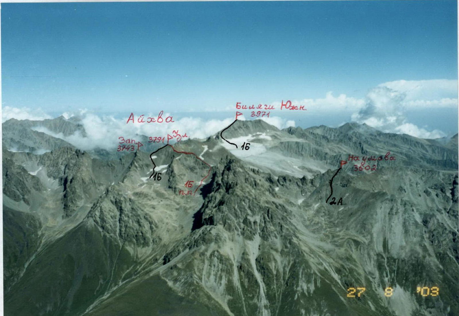 View of part of the Sugan range from the South. Classified routes are marked in black. The first ascent route is marked in red.
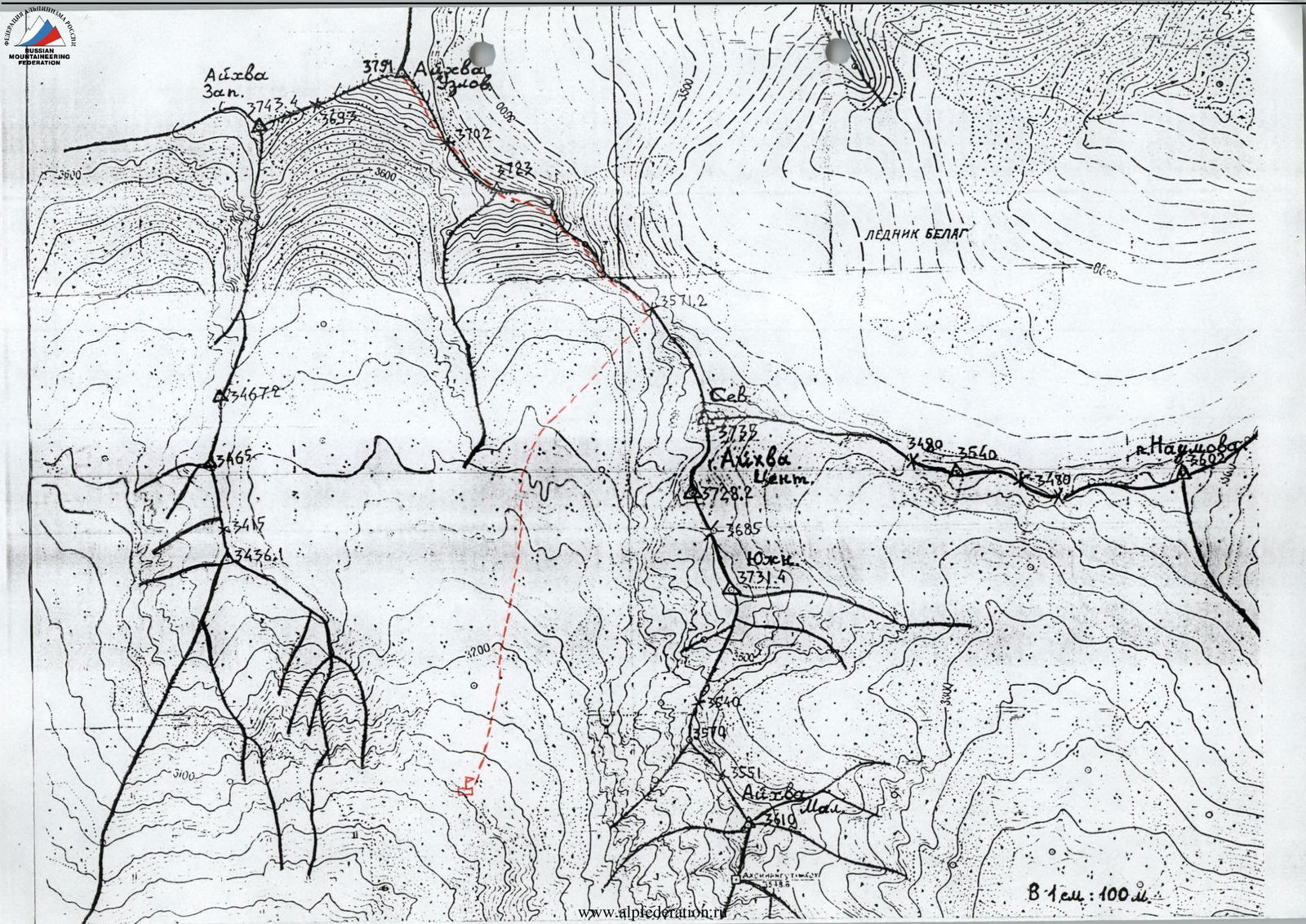 1 cm: 100 m.
 Route to Aikhva Uzlovaya via the South-East ridge.
Description of the Approach to the Route (to the Western Aikhvinsky Cirque)
From the "Digoria" alpine camp (now the "Komy-Art" sports and recreation camp), ascend along the road up the Khares gorge to the waterfall, about an hour. The waterfall near the road is the Aikhvadon river, flowing out of the Western Aikhvinsky cirque, which is located west of the Southern (Aikhvinsky) spur of the Sugan range.
Bypass the waterfall on the road and cross Aikhvadon to the right bank above it. Continue ascending towards the visible massif of Aikhva. Initially, walk through meadows, then reach the right grassy ridge and follow it until it levels out into a wide, almost flat, grassy valley — another 1.5 hours (altitude around 2700 m).
Further:
- Walk straight up along the river to a steep moraine rise.
- Ascend directly up the moraine rise on the trail, and to the right of the glacially scoured bedrock, where there is water, reach the camping sites — another approximately 1.5 hours.
The altitude here is 3100 m, with the Aikhva massif clearly visible ahead. The total ascent from the alpine camp is about 1300 m.
Conclusions and Recommendations for the Route
The route corresponds to the claimed category. Passing this route develops skills for ridge climbing. Belays on the route are primarily through rock features. Recommended for training groups as a good training route.
At the beginning of the season, for a training group, the following may be necessary:
- Crampons when exiting onto the ridge (hard snow),
- possibly crampons on the descent.
Route Description
From the upper Aikhvinsky camping sites, ascend directly towards the characteristic peak of Aikhva Severная (this is the farthest rock tower when looking North from the campsites). The path goes through moraine boulders, and in the first half of summer, through snowfields. After an hour, the lowest col in the ridge comes into view — this is the Aikhva pass; approach the pass ascent.
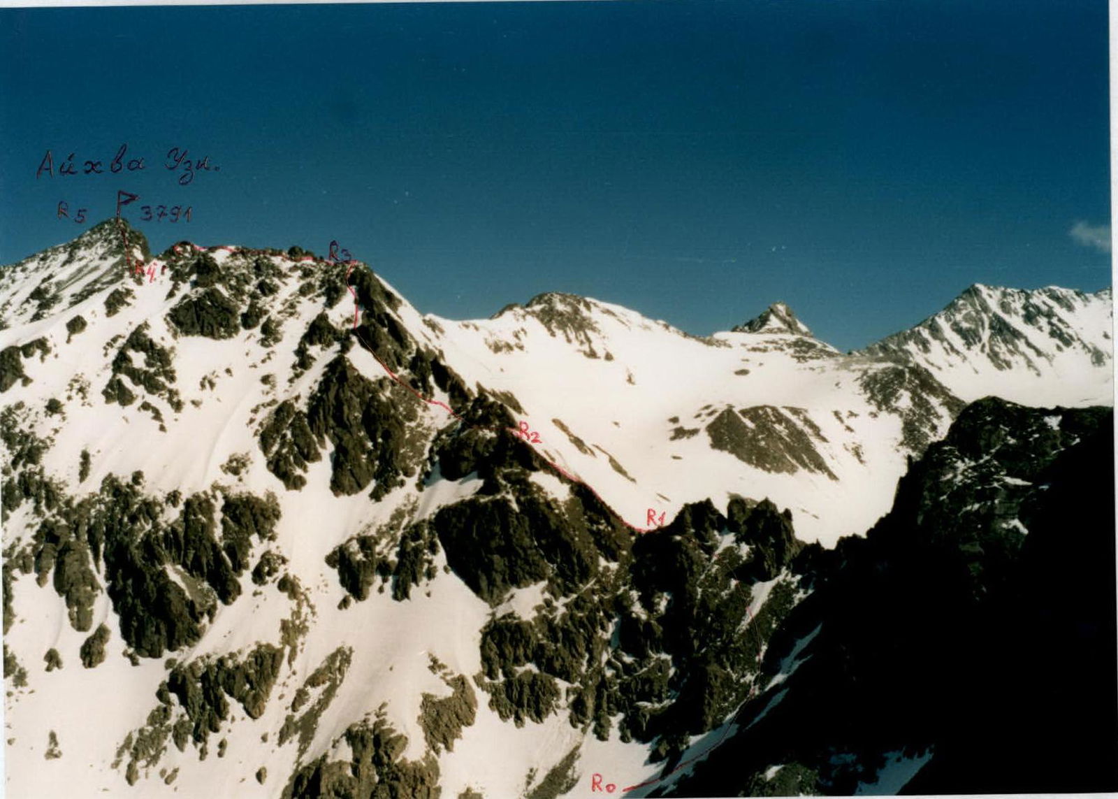
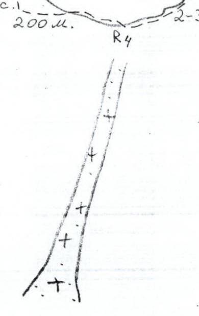
Section R0–R1: Ascend the snow-talus slope (1, 20–30°), before reaching the ridge, veer left, bypassing the gendarmes from the South. Upon reaching the col, there's a ledge. Section is about 150 m.
Section R1–R2: Along the ridge, primarily on its right side, ascend to a steep ridge rise. Section is about 100 m; 1–2; 20–30°.
Section R2–R3: Before the steep rise, veer left onto the southern slopes. Ascend these slopes towards a snow-talus shoulder, left of the ridge (at the start of the season, there may be hard snow here in the morning). After the shoulder, continue left of the ridge and exit onto the ridge shoulder. Section is about 150 m; 1–2; 20–30°.
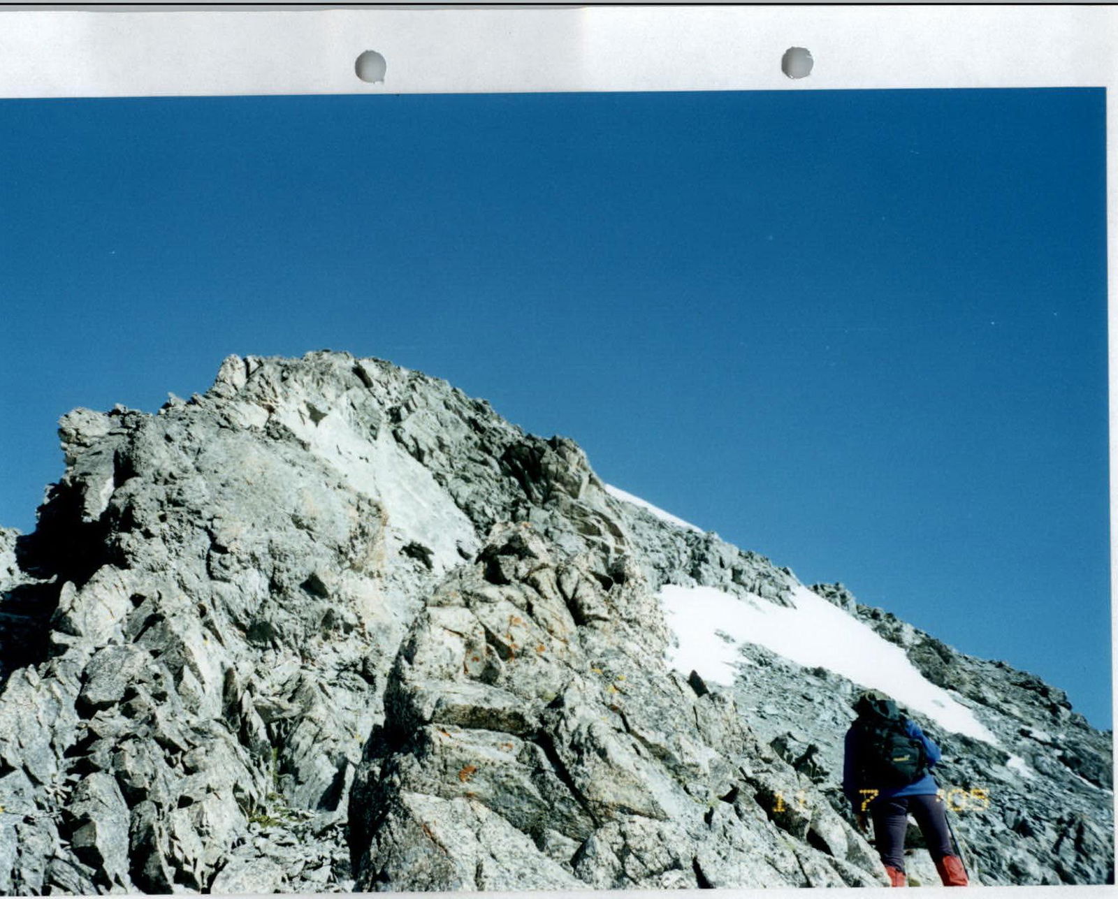
Section R3–R4: Bypass the gendarmes on the ridge on the left, on slopes 2–3. After 100 m, begin descending into a col — rocks 2–3. Sections of rock are местами up to 60°. The entire section is about 200 m.
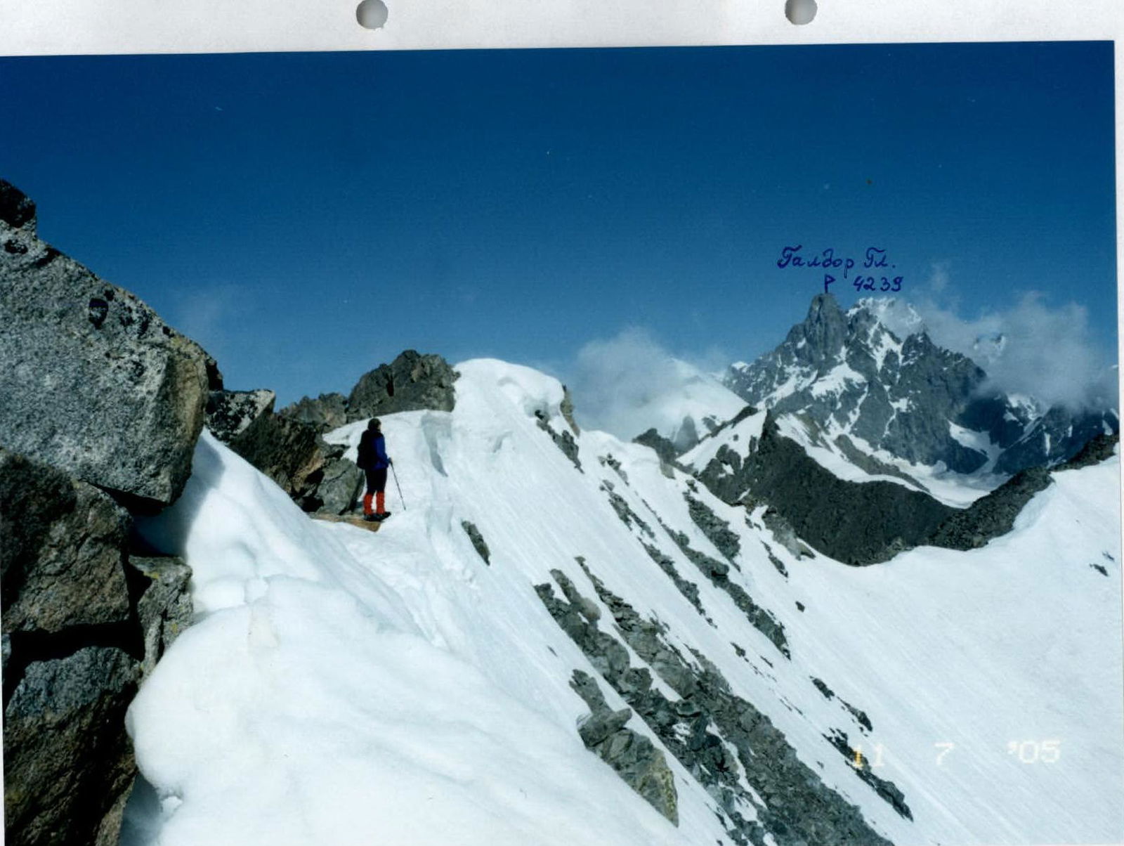
Section R4–R5: From the col, ascend on the left side of the ridge, bypassing complex rock sections 2–3; 30–40°; and after 200 m, reach the summit of Aikhva Uzlovaya (3791 m). From the campsites, 4–5 hours.
The summit is a good panoramic point.
Descent is possible:
- Along the Western ridge,
- From point R4 to the West via a couloir (loose rocks!) into the cirque under per. Svetlova.
 Aikhva Uzlovaya 3791 m.
 Middle of section R1–R2.