2.6.95
Ascent Passport
-
Ascent class: rock
-
Ascent area: Caucasus: 2.6: Sugansky Ridge
-
Peak, route: Aikhva Uzlovaya (3791 m): via West ridge
-
Estimated category of difficulty: 1B category of difficulty: p/p
-
Route characteristics:
height difference — about 100 m, route length — 310 m, length of sections: 3 (8 m) 2 (160 m) average steepness of the main part of the route — 45°
-
Pitons hammered in: insurance through выступы (outcrops)
-
Number of climbing hours/days — 2.5 hours / 1 day
-
Number of overnight stays: 1 — at a bivouac
-
Leader — Levkovsky Yu.V., CMS Participants: Bednyagin S. — candidate master Kodzayev D. — merit badge Redukhov O. — novice Tryakichev G. — novice
-
Coach: Akhtyrchenko Galina Vasilievna — Master of Sports
-
Departure to the route: August 4, 2000 return to bivouac: August 4, 2000
-
Organization: AUSB "Digoriya".
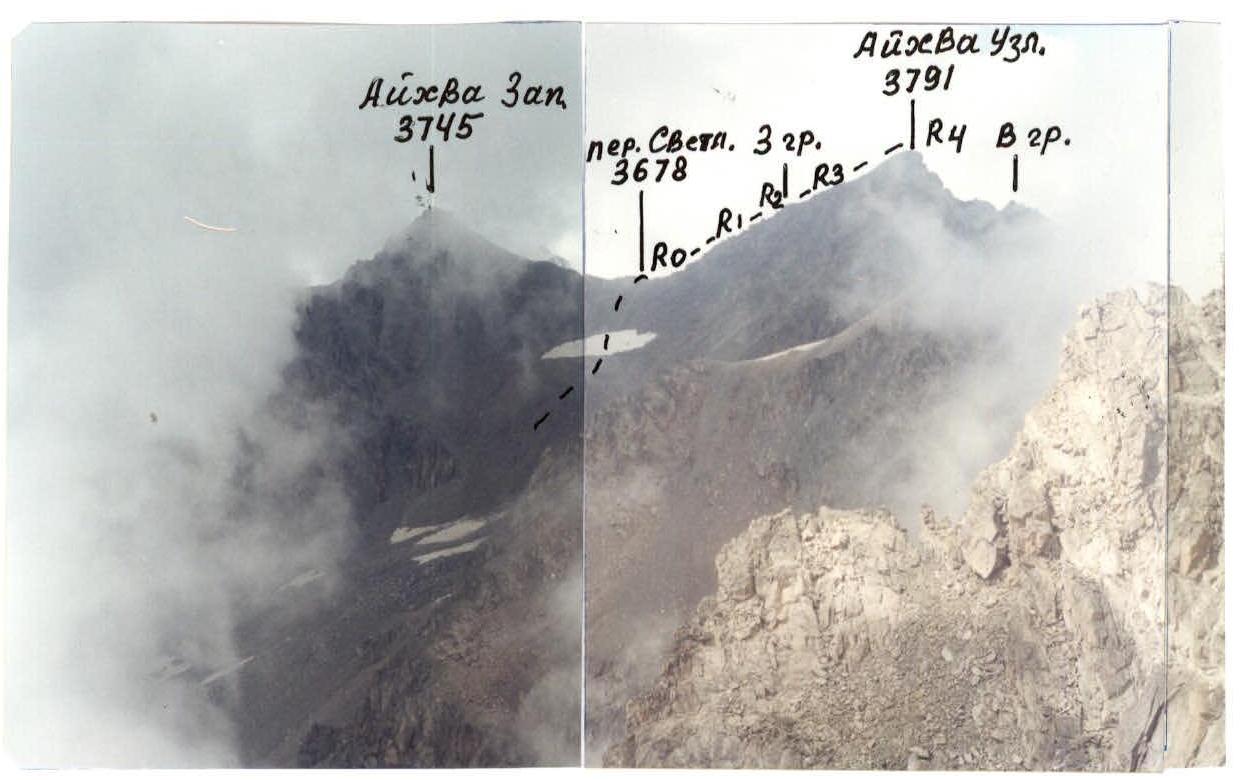
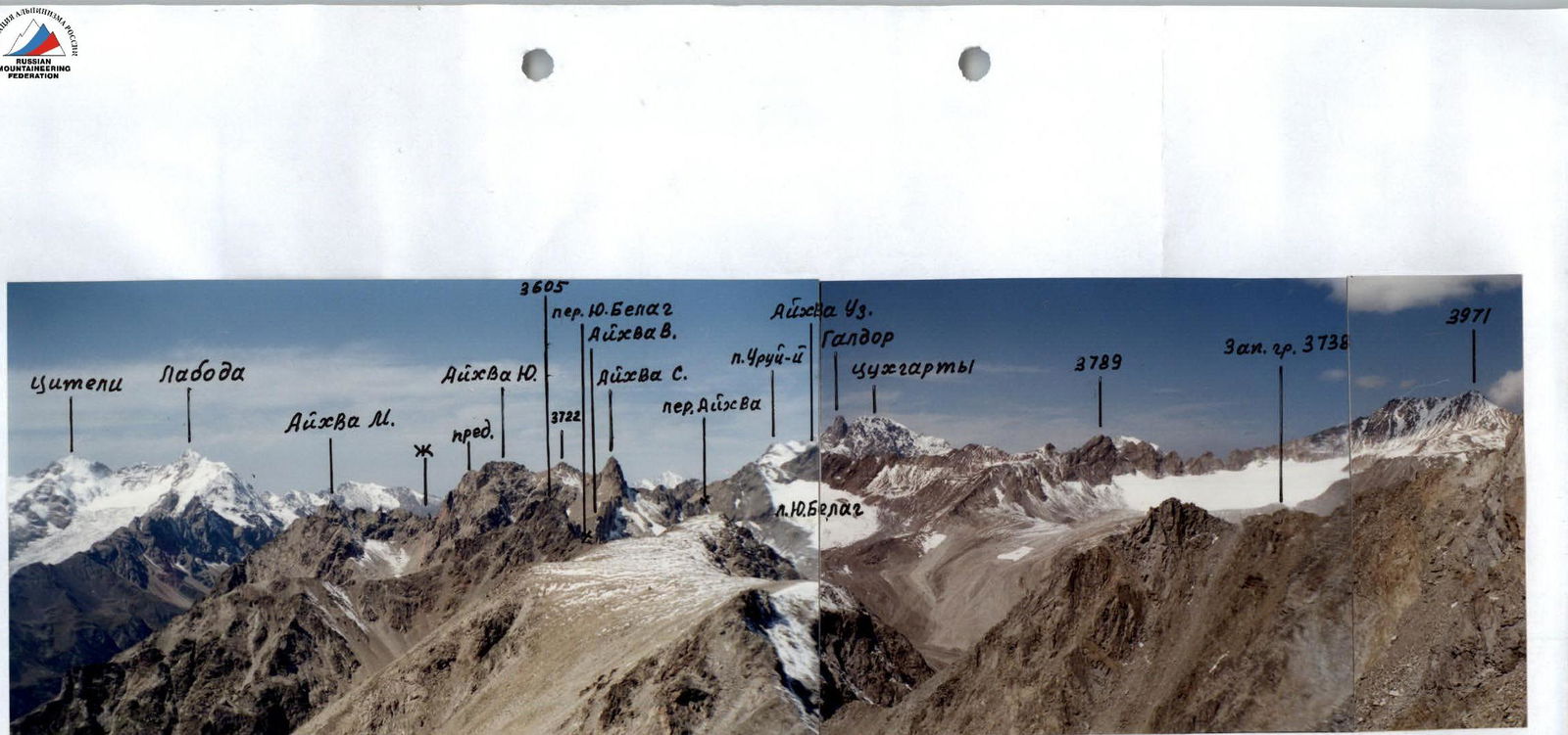 Fig. 1. V. Aikhva Uzl. View from the south (from v. Aikhva Yuk.)
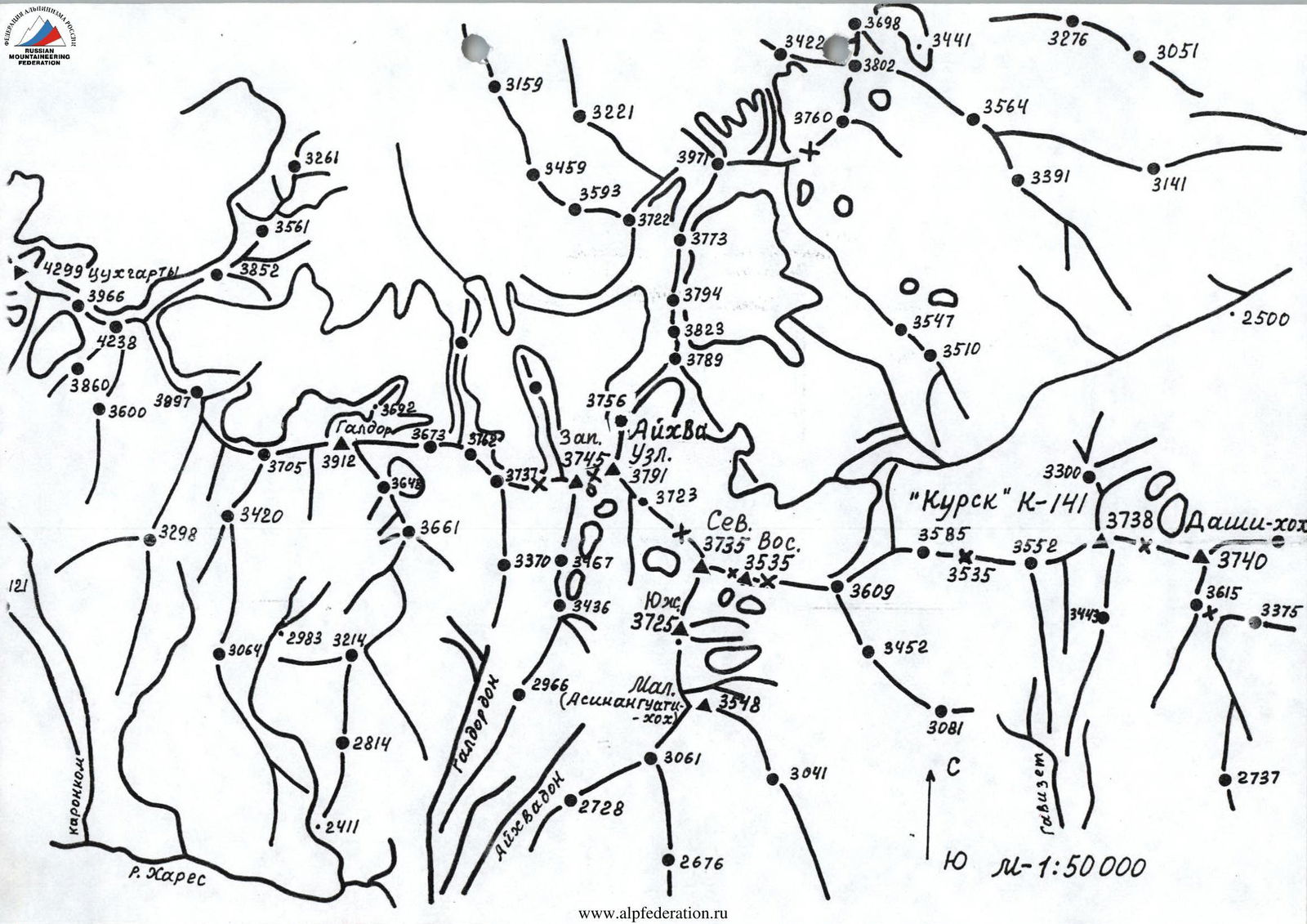 Fig. Eastern part of Sugansky Ridge. View from the east, from v. "3738 m"
 www.alpfederation.ru↗
View from PGA
Brief overview of the ascent area, history of development.
In the eastern part of the Sugansky Ridge between the peaks: p.Urui-magova (3884 m) to the west and v.Dashi-khokh (3740 m) to the east lies the Aikhvinsky mountain node, consisting of a part of the Sugansky Ridge and the Southern spur extending from it to the south.
The mountains of the Aikhvinsky node are composed of granite rocks, strongly destroyed in the west and north, and quite monolithic in the east and south.
To the north extends a large Belyagi ridge with pronounced peaks, near which lies the eponymous glacier. From the southern slopes descend steep screes, turning into moraine hills covering small cirque glaciers, giving rise to the rivers: Aikhvadon and Khurykomdon, bounding the Southern spur on the left and right and flowing into the Kharres River.
In the spring-winter season and at the beginning of summer, a fairly large amount of snow lies in the cirques and on the ridges, some of which remains for the whole summer and autumn.
Below the line of moraines and screes to the south to the Kharres River descend steep, extensive grassy slopes, overgrown with pine forests in the lower part.
Approaches to the Aikhvinsky mountain node are possible from AUSB "Digoriya" and "Rostselmash", as well as along the Bilyagidon River — from the north.
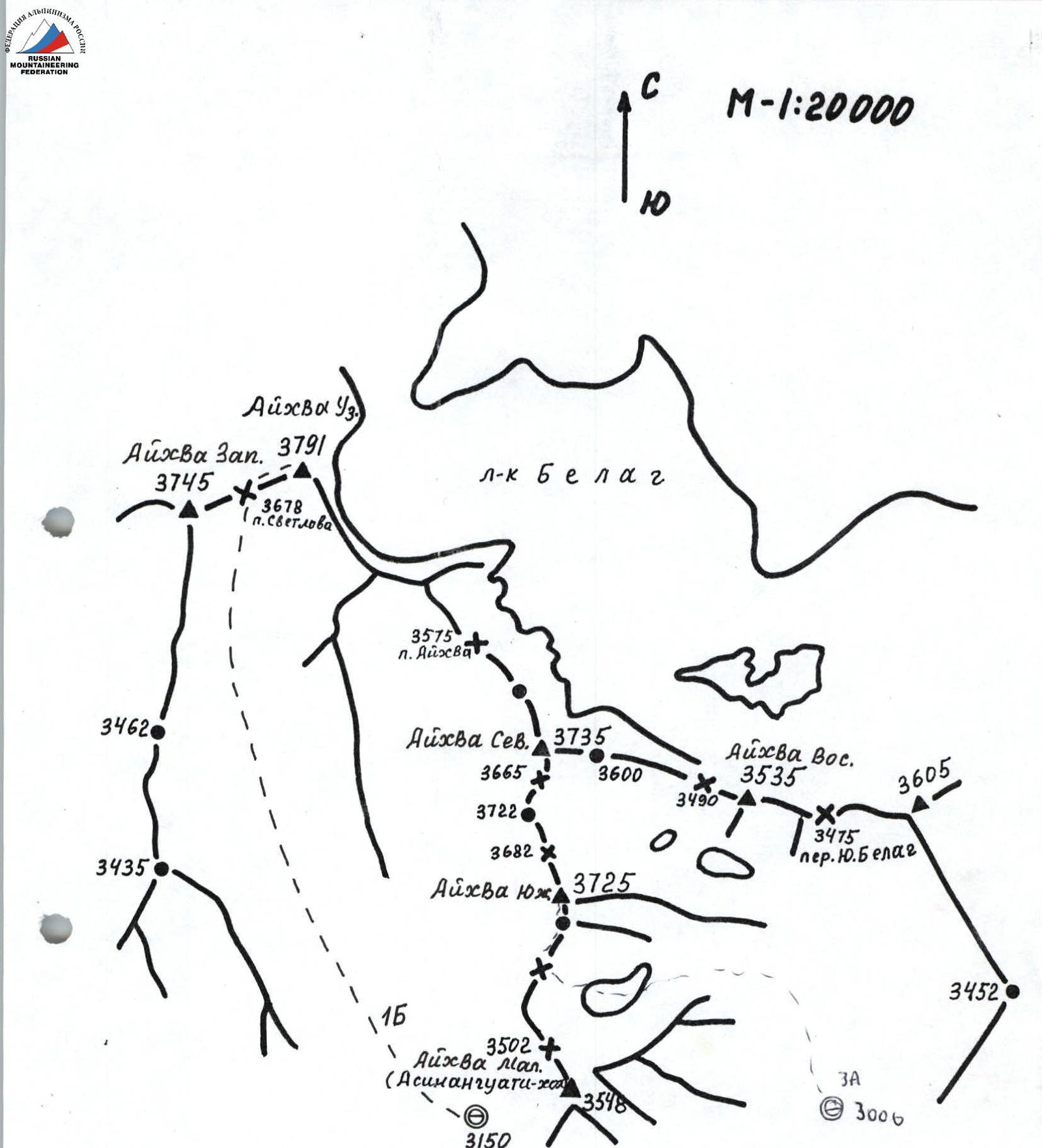
The area was mainly visited by surveyors and geologists. Climbers have poorly освоined it. In 1991 A.Zaidler made ascents to v.Aikhva (Uzlovaya) (3791 m) and Aikhva (Malaia). He also suggested calling v.Aikhva (3791 m) — v.Aikhva Uzlovaya, which connects the Sugansky Ridge with the large Belyagi ridge.
An ascent was made to v.3580 m (3548 m) along the southern ridge and named Aiva Malaia. In the future, ascents were made to v.Aikhva Uzlovaya and the peaks of the Southern spur, which were alternately called v.Aikhva Malaia, depending on which one the climbers ascended. Due to the insufficient qualification of climbers and the lack of accurate maps and photographs, many uncertainties and confusion arose both in the location of the peaks and their names, and in the descriptions of the routes.
In 2000, in order to develop new, more accessible training and sports groups routes, under the leadership of the Deputy Director for educational and sports work of AUSB "Digoriya" G.V.Akhtyrchenko, several ascents were made to the peaks of the Aikhvinsky mountain node.
In the future, photographs of the area and sections of the routes were taken, detailed map schemes were made with the help of geologist from Vladikavkaz O.A.Goncharenko, and an analysis of the location of the peaks was carried out, and the boundaries of the Aikhvinsky mountain node were clarified.
As a result, it was established that the boundaries of the Aikhvinsky mountain node can be: to the west — per.Uruimagovoi, to the east — per.Yu.Belag, to the north — per.Kedrina and to the south — the end of the Southern spur. The area (node) itself is represented by peaks with the common name Aikhva, which can be subdivided into: v.Aikhva Uzlovaya (3791 m), connecting the Sugansky Ridge with the northern Belyagi ridge; V.Aikhva Zapadnaya (3745 m), located between per.Uruimagovoi and per.Svetlova (3678 m): v.Aikhva Vostochnaya (3535 m), bounded on the east by per.Yu.Belag. The remaining peaks are located in the Southern spur: v.Aikhva Severnaya (3735 m) rises with a sharp tooth at the point of connection with the Sugansky Ridge and is the northern peak of the spur: v.Aikhva Yuzhnaya (3725 m) is located in the middle part of the spur and V.Aikhva Malaia (3548 m) (local name — Asinanguati) is the end of the Southern spur.
Only Aikhva Zapadnaya is of no particular interest to climbers, having simple scree ridges. The remaining peaks are led by routes from 1B to 3B category of difficulty.
Description of the approach
From AUSB "Digoriya" move up the road to the waterfall — 1 hour. Further, the road turns to the right — up and leads to the farm.
Before the farm, descend to the right to the Aikhvadon River, cross to the other side and then climb to the left — up along the steep grassy ridge-slope to its transition into a large meadow. Up the meadow towards a large stone. Further along the bottom of the gorge along the stream to the confluence of two streams. At this point — a large stone, above — to the left — a small waterfall.
Turning to the right — up, climb along the moraine ridge overgrown with grass, leading to the right side of the cirque.
In the upper part of the moraine, before the rocky walls of the 103 spur, traverse to the left through the dry riverbed, then up along the large stones of the scree exit to the lower step of the cirque. Among the stones flows a stream, to the left on the scree slope are good sites for a bivouac.
From AUSB "Digoriya" — 5 hours.
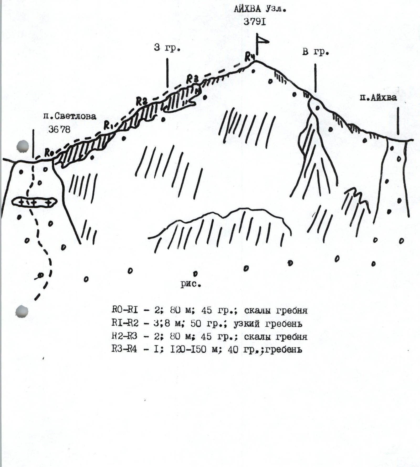
Route description
From the bivouac in the lower part of the cirque, move to the left — up along the moraine hills, keeping to the right side of the rocky ridge coming from v.3745 m to the south.
In 30 minutes, a wide scree per.Svetlova (3678) is visible ahead, located between v.3745 m and v.Aikhva Uzlovaya.
Climb to the pass along the steep fine and medium scree, possibly snow. From bivouac — 1.5 hours. On the pass, a cairn is built, to the right on the rocks — memorial plaques.
Turning to the right, climb to the western ridge along steep destroyed rocks.
Further along steep monolithic rocks with good holds 8 m of a narrow 50 cm ridge, then along the destroyed rocks of the ridge ascent, along which after 120–150 m exit to the summit.
From per.Svetlova — 1.5–2 hours. Descend along the ascent path or along the well-trodden scree ridge to the east to the saddle, from which down to the south along the steep scree couloir into the cirque and further to the bivouac.