- Climbing category: rock climbing
- Climbing area: Caucasus: 2.6: Sugansky Ridge
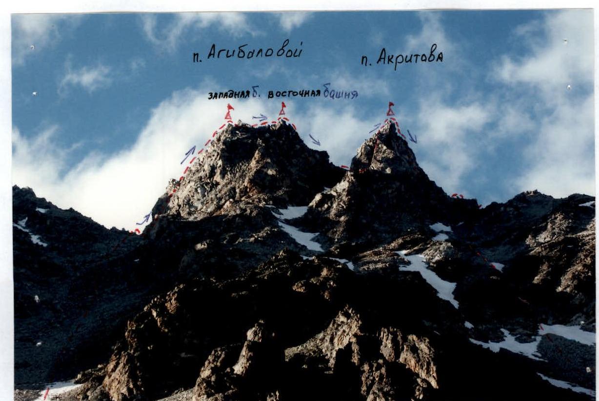
- Peak, route: traverse of Agibalova peaks (West-East towers) – Akritov.
- Estimated category of difficulty: 3A rock: semi-independent
- Route characteristics:
height difference — about 900 m, route length — 1050 m, section lengths: 4th category of difficulty — 25 m, 3rd category of difficulty — 210 m, 2nd category of difficulty — 150 m, average steepness of the main part of the route — 65°
- Equipment used: pitons — 4 pcs., chocks — 12 pcs., "friends" — 2 pcs.
- Number of walking hours (days): 10/1
- Number of overnight stays: 1 — at a bivouac
- Leader: Kovgan E. V. — Candidate Master of Sports.
Team members: Aleksashin M. I. — 1st sports category, Levitsky Ya. G. — 3rd sports category, Sudanova L. M. — 3rd sports category
-
Coach: Akhtyrchenko Galina Vasilievna — Master of Sports
-
Departure on the route: July 5, 2003, 5:00 Moscow time. Return to the bivouac: July 5, 2003, 14:00 Moscow time
-
Organized by: AUSB "Digoria"
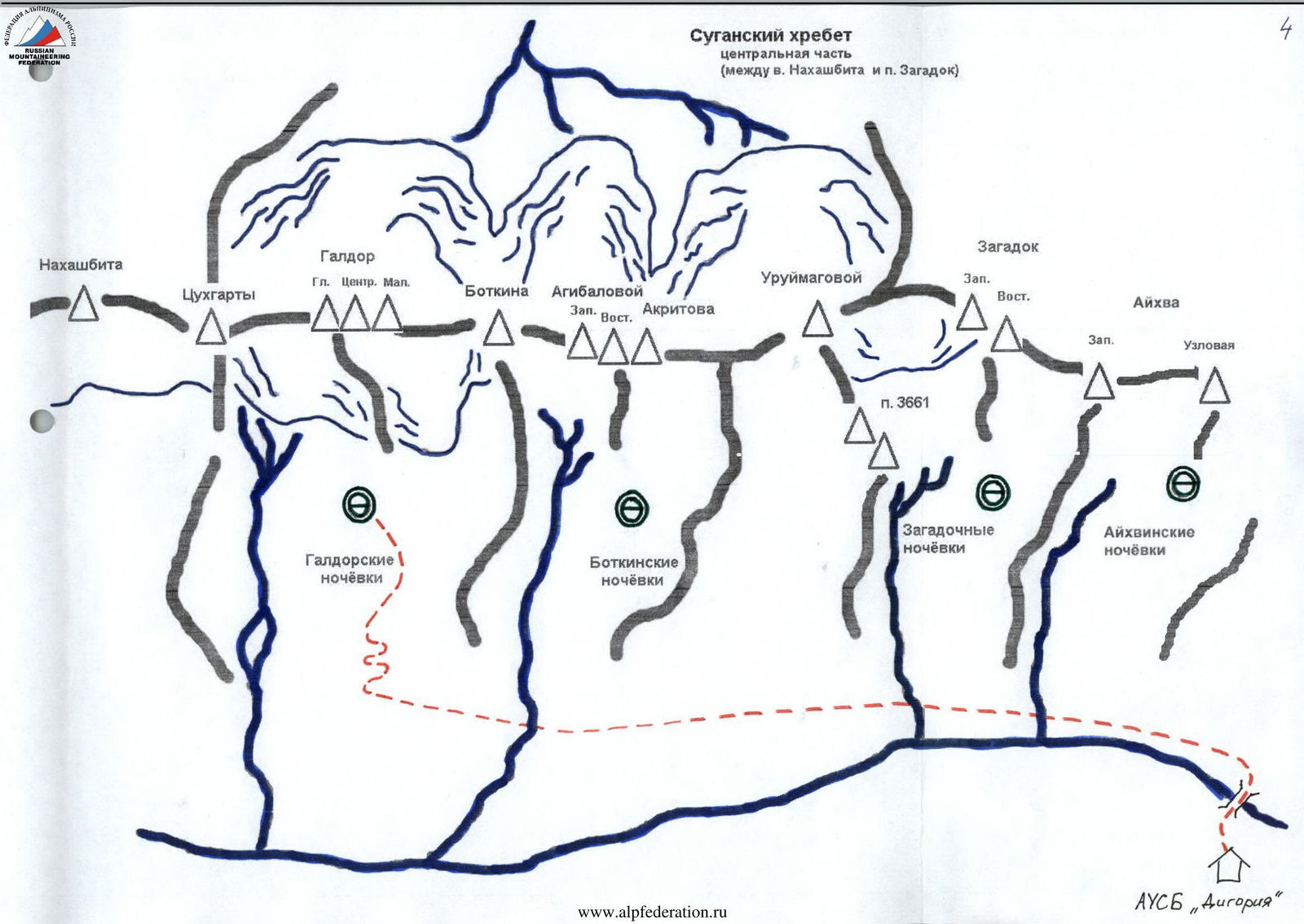
Description of the approach to Galdor overnight stays
After leaving the camp, approach the fork in the road and turn left. Moving along the serpentine for about 1 hour, approach a large waterfall on the right. Here is a halt.
Then proceed 100 m along the road and turn left. Cross over to the trail, which goes traversing along the slope. Exit the trail to the destroyed settlement and, continuing along the road, cross a small river via stones. From this place, proceed another 300 m along the road, which turns into a trail, to a fork. From here, you need to take the trail that leads to the right and upwards. The trail leading to the left leads to narzan springs.
In 20 minutes, you will reach a large clearing. Cross it, keeping to the slopes on the right. Cross the first river along the way and begin ascending the right slope to the rock outcrops — in the place where the road makes a sharp turn upwards from a large white stone near a stream. There, find a disappearing trail and move along it towards the second river, continuing the ascent.
In 1 hour, you will approach small "baranii lby" (rocky outcrops) and go around them on the right. From this place, a clearly visible trail leads to the overnight stays. When approaching them, you need to ascend a small moraine ridge, behind which large grassy clearings open up. This is the Galdor overnight stays.
For orientation:
- The overnight stays are separated by two large talus ridges on the left and right.
- On the left ridge, there is a pass between two large stones ("Elephant ears").
- Straight ahead, a large couloir leading to the pass between Maly and Central Galdor should be visible.
- In front on the left, the tower of Main Galdor and Tsukhgartы rises.
- In front on the right — p. Botkina.
Sugansky Ridge
central part
(between v. Nakhashbita and p. Zagadok)

Route description
After leaving the Galdor overnight stays, cross the large talus ridge in the right part of the clearing and move into the circus (Botkin overnight stays area). The transition takes 30–40 minutes.
Moving under the cliffs in the upper part of the circus, approach the long couloir leading to the pass between the peaks of Botkina and 3878. Ascend the talus (in the lower part — snow-covered) couloir to the pass between p. Agibalova (3705) and p. Botkina (1–1.5 hours), keeping to the right side. From the pass, move to the right.
Move along the southern (left) side of the ridge, bypassing the gendarme. Overcoming the internal angle 10 m, 2–3 (pitons), exit to the shelves. Belay! They lead to a platform very convenient for team assembly. It is recommended to organize the first belay station there.
Movement along the rope. Here begins the first key section of the route:
- A 50 m wall is overcome via cracks and an internal angle on the right and then left side
- Leads to the Western tower of p. Agibalova
Further:
- Descend along steep inclined shelves to a platform
- Go around a large gendarme with a stone in the form of a tooth on the right
- Move along the sharpened ridge ("saw"), 3–4
- Leads to the Eastern tower of p. Agibalova
From there:
- Make the first rappel — 10 m to a destroyed tooth with a tiny platform
- Second rappel (35 m) — along stone "feathers" oriented north
- Find yourself on a shoulder leading towards p. Akritov
- Organize another rappel (15 m), descend to shelves leading to a monolithic "pedestal"
In case the route is climbed with a 50-meter rope, it is possible to manage with the length of one such rope for the second rappel.
From the "pedestal" begins the second key section of the route:
- A 50-meter wall with an average slope of 70°
- Overcome by moving right-up under the cornice via unreliable, weakly expressed holds
- Bypass the tower and find yourself on the southern edge, which leads to a more gentle part of the wall
- It is advisable to make a station (landmark: old pitons with a loop)
- From the "pedestal" to this point — 50 m
Further:
- 20 m of relatively simple climbing to the summit
- Do not neglect belay!
From the summit:
-
Descend via an oblique rappel along the eastern ridge towards the saddle between p. Akritov and p. Uruimagov. The length of the descent is 70 m
- First 30 m — to a vertical wall
- Second rappel — 50 m of steep descent to a snow-covered shoulder
-
Once on the saddle, move towards p. Uruimagov for 100 m
-
Begin descending south along a talus (possibly snow-covered in places) couloir
Second (reserve) descent option:
- In case of worsening weather conditions, descend from the route in the area of the "pedestal"
- Rappel (50 m) from the "pedestal" south to a small snow-covered gully — It leads to the right (ascending) couloir.
The route is logical and objectively safe.
View of the route from the south
Route sections (view from the north)
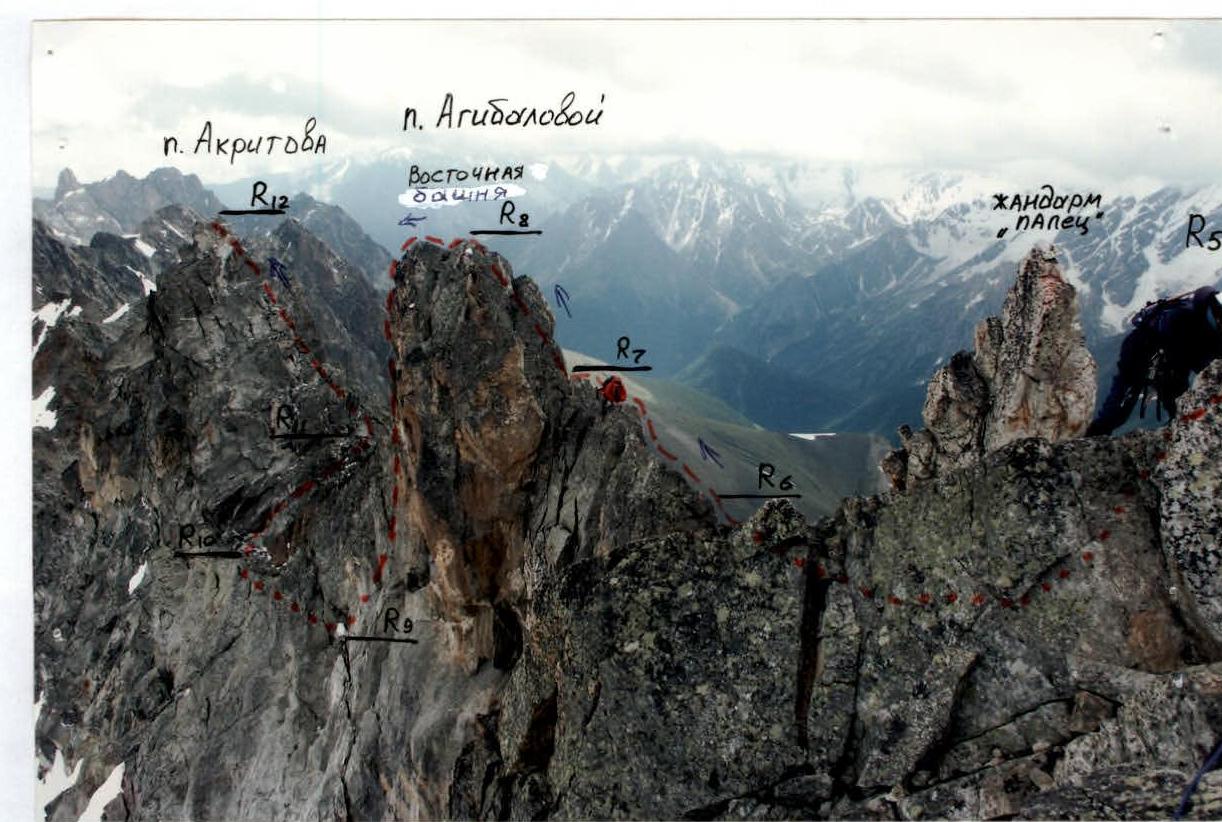
Table of main characteristics of the route sections
| Section # | Steepness, ° | Length, m | Terrain characteristics | Category of difficulty | Belay |
|---|---|---|---|---|---|
| R0 | 30 | 300 | Talus | 1 | simultaneous |
| R0–R1 | 40 | 600 | Talus | 1 | simultaneous |
| R1–R2 | 50 | 10 | Talus, snowfield, destroyed rocks | 2+ | Pitons, chock stones |
| R2–R3 | 50 | 35 | Shelves and walls of gendarmes, internal angle | 2 | Pitons, chock stones |
| R3–R4 | 60 | 25 | Chimney, несложные стенки. Выход на Западную вершину пика Агибаловой | 2+ | Pitons, chock stones |
| R4–R5 | 10 | 20 | Inclined slate shelves | 3 | Pitons, chock stones |
| R5–R6 | 40 | 20 | Simple destroyed shelves | 2 | Chock stones, quickdraws |
| R6–R7 | 0 | 25 | Rock knife | 4 | By protrusions |
| R7–R8 | 65 | 10 | Wall. Exit to the Eastern summit of p. Agibalova | 3 | Slings |
| R8–R9 | 85 | 50 | Wall | 3 | Rappel |
| R9–R10 | 10 | 25 | Slate destroyed shelves | 2 | Pitons, chock stones |
| R10–R11 | 70 | 55 | Wall, internal angle, shelves | 3+ | Pitons, chock stones |
| R11–R12 | 60 | 25 | Wall. Exit to the summit of p. Akritov | 3 | Pitons, chock stones |
pik Agibalova (3705 m)

Recommendations
The route is logical and objectively safe, passable at any time of the year. The approach is convenient from Galdor or Botkin overnight stays.
Only depart on the route in good weather. Recommended for training groups and sports teams. Departure is recommended for 4:00–5:00.
The ridge is heavily destroyed — in some places, belay via protrusions is problematic due to the possibility of breaking them off.
Since Sugansky Ridge serves as a barrier for clouds moving from the Khares river valley, good visibility on the route is ensured only from the east and south sides.
There are many cracks on the route suitable for using chock stones like "friends" and pitons (mainly channel pitons). For other types of chock stones, the possibility of finding a suitable crack is less.
On the ridge, use belay via protrusions.
Ice equipment was practically not used (except for crampons and ice axes in the initial part of the route in case of snow cover on the couloir).
Descent slings will be needed.
It is advisable to have 3 ropes of 50 m each. This significantly simplifies the passage of key sections and rappels.
The route is fully passable in boots, without using special rock climbing shoes.
The route is technical and not recommended as the first route for beginners climbing 3A category routes.