Ascent Passport
-
Ascent category: rock climbing
-
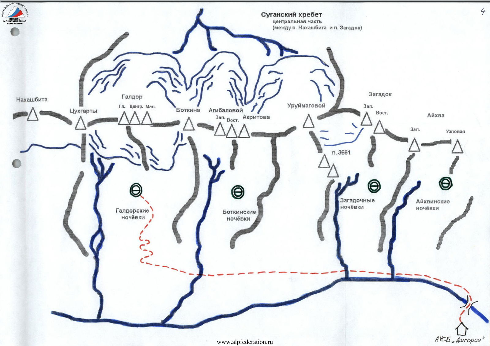
Ascent area: Caucasus: 2.6: Sugansky Ridge
-
Peak, route: peak Agibalova (3705 m): via West-East towers, traverse
-
Estimated category of difficulty: 2A, semi-independent
-
Route characteristics:
height difference — about 900 m, route length — 900 m, section lengths: 4th category of difficulty — 25 m, 3rd category of difficulty — 110 m, 2nd category of difficulty — 90 m, average steepness of the main part of the route — 55°
-
Number of pitons driven: 6 pcs., number of chocks: 5 pcs.
-
Number of walking hours / days: 7 / 1
-
Number of overnight stays: 1 — at a bivouac
-
Leader: Aleksashin M.I. — 2nd sports category
participants: Melnik I.P. — 3rd sports category, Levitsky Ya.G. — zn. †
-
Coach: Akhtyrchenko Galina Vasilievna — Master of Sports
-
Departure to the route: July 27, 2001, 05:00 Moscow time. Return to bivouac: July 27, 2001, 11:00 Moscow time
-
Organized by: AUSB "Digoria"
Approach Description
Having left the camp, approach the fork in the road and turn left. Moving along the serpentine for approximately 1 hour, approach a large waterfall on the right. Here — a halt.
Further:
- Walk 100 m along the road and turn left.
- Switch to the trail that traverses along the slope.
- Exit the trail to the ruined settlement.
- Continuing along the road, cross a small river via stepping stones.
- From this place, walk another 300 m along the road, which turns into a trail, to the fork.
- From here, take the trail that goes up to the right. The trail that goes down to the left leads to narzan springs.
- In 20 minutes, exit to a large clearing.
- Cross it, keeping to the slopes on the right.
- Cross the first river along the way.
- Begin ascent up the right slope towards rock outcrops, at the place where the road makes a sharp turn up from a large white stone near a stream.
- Find a faint trail and follow it towards the second river, continuing the ascent.
- In 1 hour, approach small "sheep's foreheads" and bypass them on the right.
- From this place, a clearly visible trail leads to the overnight stays. When approaching them, climb a small moraine ridge, behind which large grassy clearings open up. These are the Galdor overnight stays.
For orientation:
- The overnight stays are separated by two large talus ridges on the left and right.
- On the left ridge — a pass between two large stones.
- From them, a large couloir begins upwards, leading to the pass between Maly Galdor and Central Galdor.
- In front, on the left, the tower of Main Galdor rises.
Route Description
Leaving the Galdor overnight stays, cross the large talus ridge in the right part of the clearing and enter the cirque (area of Botkin overnight stays). The transition takes 30–40 minutes.
Moving under the cliffs in the upper part of the cirque, approach a long couloir leading to the pass. Ascend the talus (in the lower part — snowy) couloir to the pass between peak 3878 and peak Botkina (1–1.5 hours), keeping to the right side. From the pass, move to the right. Move along the southern (left) side of the ridge, bypassing a gendarme.
Overcoming an internal corner 10 m, 2–3 (pitons used for belay), exit to shelves. Belay! They lead to a platform, very convenient for team assembly. It is recommended to set up the first belay station there.
Movement via rope handrail. Here begins the key section of the route:
- Wall ~ 20 m. Overcome via cracks on the right, then left side, and exit to the Western tower. Set up a station.
- Further, along steep inclined shelves, descend to a platform and bypass a large gendarme with a stone in the shape of a tooth on the right. Here, set up another reliable station.
- Then, move along the sharpened ridge ("saw"), 3–4, which leads to the Eastern tower.
Descent is via the ascent route.
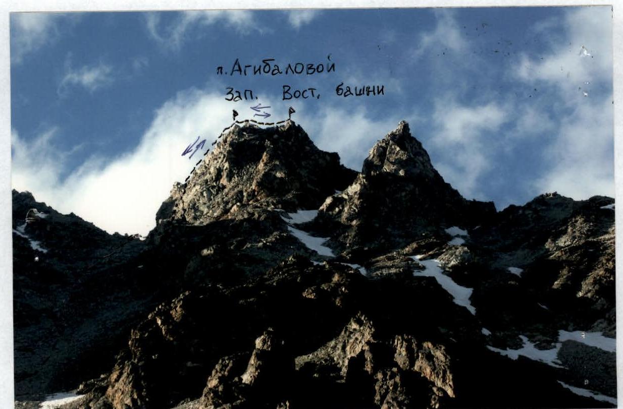
Peak Agibalova (3705 m)
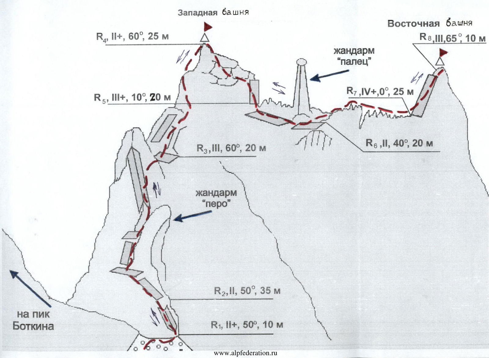 Table of main characteristics of the ascent route sections
| Section № | Steepness, degrees | Length, m | Terrain characteristics | Category of difficulty | Belay |
|---|---|---|---|---|---|
| R0 | 30 | 300 | Talus | 1 | Simultaneous belay |
| R0–R1 | 40 | 600 | Talus | 1 | Simultaneous belay |
| R1–R2 | 50 | 10 | Talus, snowpatch, destroyed rocks | 2+ | Pitons, chocks |
| R2–R3 | 50 | 35 | Shelves and walls of gendarmes, internal corner | 2 | Pitons, chocks |
| R3–R4 | 60 | 25 | Chimney, несложные стенки | 2+ | Pitons, chocks |
| R4–R5 | 10 | 20 | Inclined shale shelves | 3 | Pitons, chocks |
| R5–R6 | 40 | 20 | Simple destroyed shelves | 2 | Chocks, runners |
| R6–R7 | 0 | 25 | Rock "knife" | 4 | Natural belay |
| R7–R8 | 65 | 10 | Wall | 3 | Slings |
Recommendations
The route is logical, objectively safe, and passable at any time of year. The approach is convenient from Galdor overnight stays.
Only start the route in good weather. Recommended for training groups and sports teams. Departure is recommended for 04:00–05:00.
The ridge is heavily destroyed — in some places, belaying via rock features is problematic due to the risk of breaking them off.
Since the Sugansky Ridge serves as a barrier for clouds moving from the Khares river valley, good visibility on the route is only ensured from the eastern side.
There are many cracks on the route suitable for using chocks like "friends" and pitons (mainly channel pitons). For other types of chocks, the possibility of finding a suitable crack is lower.
On the ridge, use belay via rock features.
It is mandatory to set up reliable stations:
- On the Western tower
- Before the rock "knife"
Ice equipment was practically not used (except for crampons and ice axes in the initial part of the route). Descending slings will be needed.