ASCENT TO SHAURTU PEAK FROM THE SOUTH VIA THE COULISSE
The Shaurtu peak is located in the Kargashilsky ridge, which separates the Chegem and Cherek-Bezengi valleys. The height of the peak is 4303 m. The route to Shaurtu peak from the south was classified in 1959 as a 2B category of difficulty. The route is combined.
Route Description
Day 1.
From the "Bezengi" alpine camp, the path goes along the right-bank (orographically) moraine of the Bezengi glacier to Missees-Kosh. Then you need to descend along the trail to the glacier and move up the glacier, gradually crossing it, to reach the stream flowing from the glacier's cirque, opposite Missees-Kosh. The second stream flows from the cirque of the Salynan glacier. From the Bezengi glacier, you need to ascend to the left (orographically) moraine to the right of the stream. Further, the path goes along the stream, to the "ram's foreheads," here you should cross the stream and move up the left (in the direction of travel) side of the stream. To the first "ram's foreheads," you should again cross to the right (in the direction of travel) side of the stream and ascend first through the grass, and then through the talus in the direction of the glacier's tongue. At the point where the glacier flattens, there is a convenient camping spot. The journey from the camp takes 4-5 hours.
Day 2.
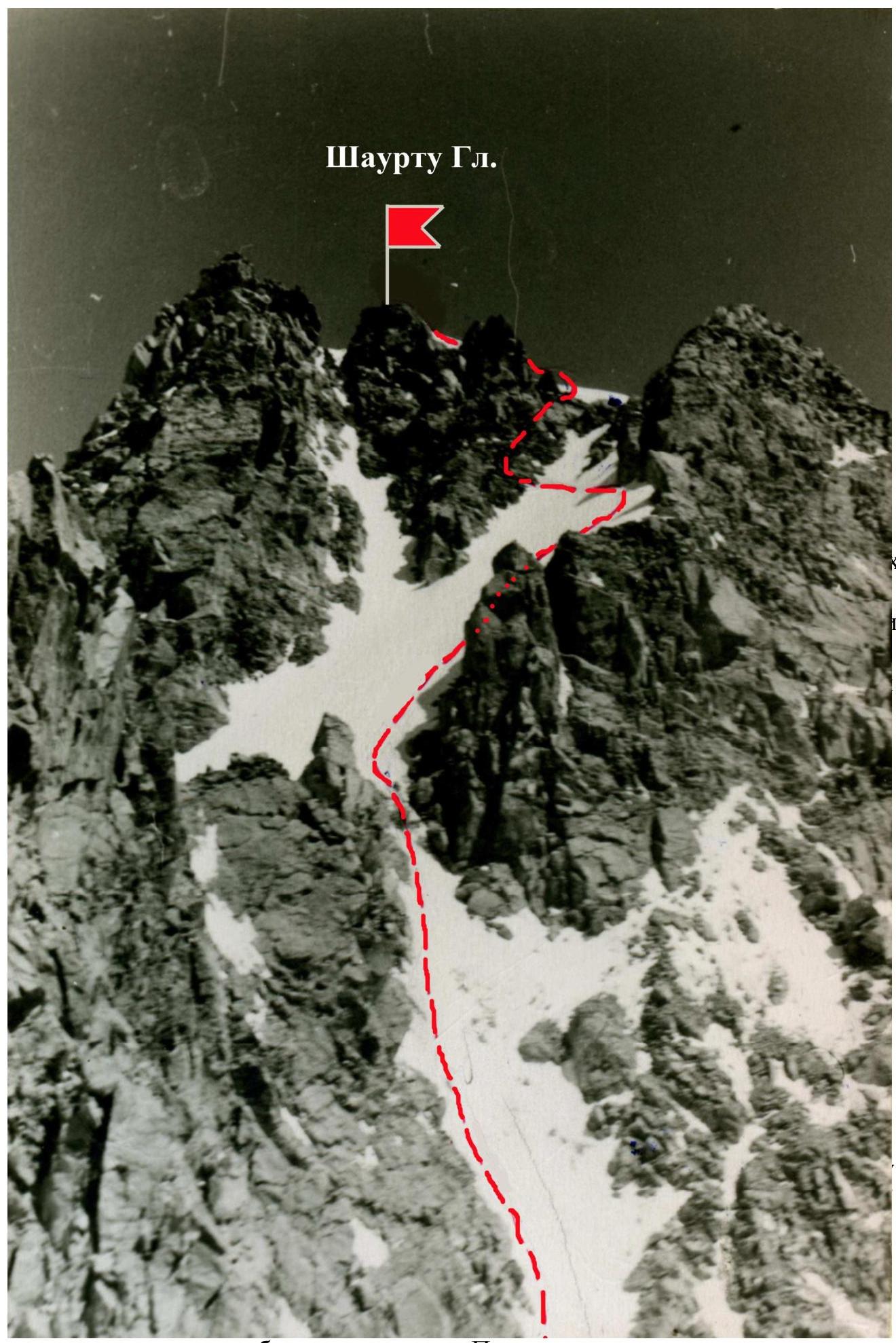
You should start early, around 4-5 am, to traverse the upper part of the glacier and the coulisse on firm snow. You need to enter the glacier in its gentle part and move straight up the glacier. The icefall between the upper and lower parts of the glacier is bypassed on the right through the snow outwashes from the lateral coulisses, and in its uppermost part - on the ice. The upper part of the Salynan glacier is closed; beware of crevices. The path to the upper cirque from the camping spot takes approximately 1 hour. Upon entering the upper cirque, a very wide coulisse opens to the right - snowy, with large talus islands. The path goes through the middle of the coulisse, on snow, as long as the snow depth is sufficient for belaying. Then you need to move to the left side of the coulisse, which consists of easy rocks with large talus sections. In the upper part of the coulisse, there is a rocky island. At the level of this island, you need to cross the coulisse and reach the island. From the rocky island at the top of the coulisse, a rocky pinnacle is visible. From the island, the exit to the ridge is to the right of the pinnacle. From the col to the right, the Shaurtu peak is visible. The path to the peak goes to the left of the ridge on snow with alternating belays. Further, you need to cross the snowy coulisse, which leads to the Shaurtu ridge, and exit onto a rocky counterfort. Here - hook belay through a rock (to the right of the rocks) or ice hook. The exit to the ridge along the counterfort is straightforward. Further, to the left along the snowy ridge, the exit is onto the peak. The peak is rocky. Descent is via the ascent route. The journey from the camping spot to the peak takes 5-6 hours. On the same day, you can return to the camp.
Set up the tent in a safe location. The journey from the stream's mouth to the camping spot under the route takes 3-4 hours.