Ascent Passport
-
Climbing category: rock.
-
Ascent area: Central Caucasus, Bezengi.
-
Object of ascent: v. Ural V. via the SE wall.
-
Proposed route - 5B category of complexity, first ascent.
-
Height difference - 550 m, length - 684 m.
Length of sections with 5-6 category of complexity - 545 m. Average steepness of main sections is 70° (3600-4080), including 6 category of complexity at 87° (3600-3685); 85° (3715-3770).
-
Pitons hammered:
rock 65, bolt 7, chocks 72, 3.
-
Team's man-hours - 20 and days - 2.
-
Overnight stays: 1st - on a site in a tent, sitting, uncomfortable.
-
Leader: Makarov Vladimir Konstantinovich - CMS, participants: Efremov Vladimir Vasilievich - CMS; Uvarov Yuri Yurievich - CMS, Ryzhikov Ilya Anatolievich - CMS.
-
Coach: Kudinov Igor Borisovich, MS USSR, ZTR RSFSR.
-
Approach to the route - August 15, 1986.
Summit - August 16, 1986. Return - August 16, 1986.
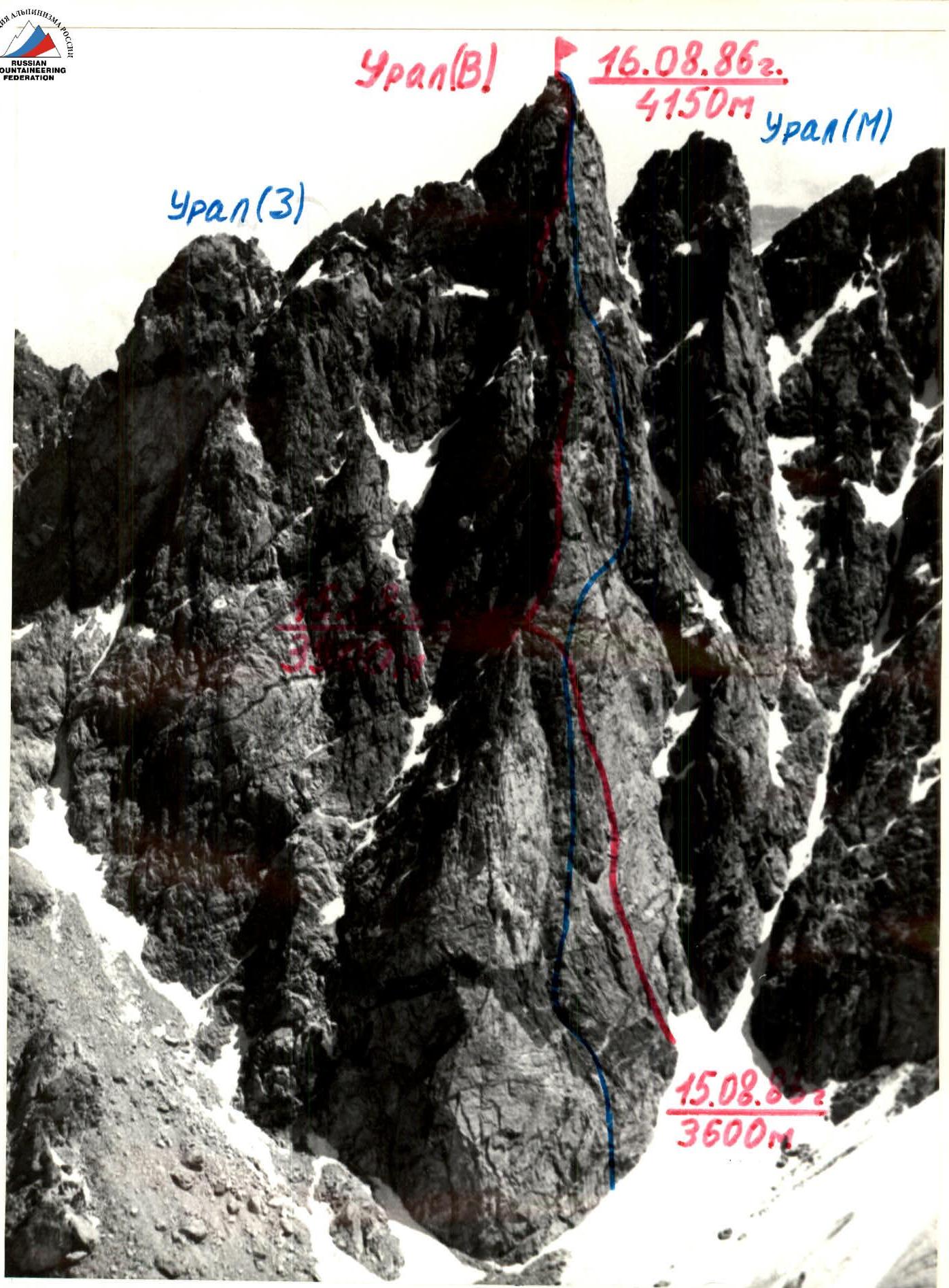
Photo 1. General photo of the summit. July 8, 1985. 12:00. Lens N-61. F=52.4 mm. Distance - 1.5 km. Shooting point - 1. Height of shooting point - 4300 m. Route via the SE wall NKYu (Additions to KTMGV, issue 2, 1983, pos. 200, sect. 25). Route taken by the team, 1986.
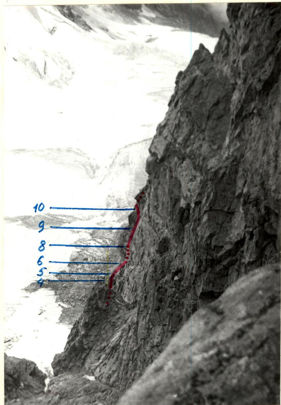
Photo 2. Profile of the wall on the right. August 21, 1986. 15:28. Lens "Helios-89". F=30 mm. Distance - 700 m. Shooting point - 4. Height of shooting point - 4000 m.
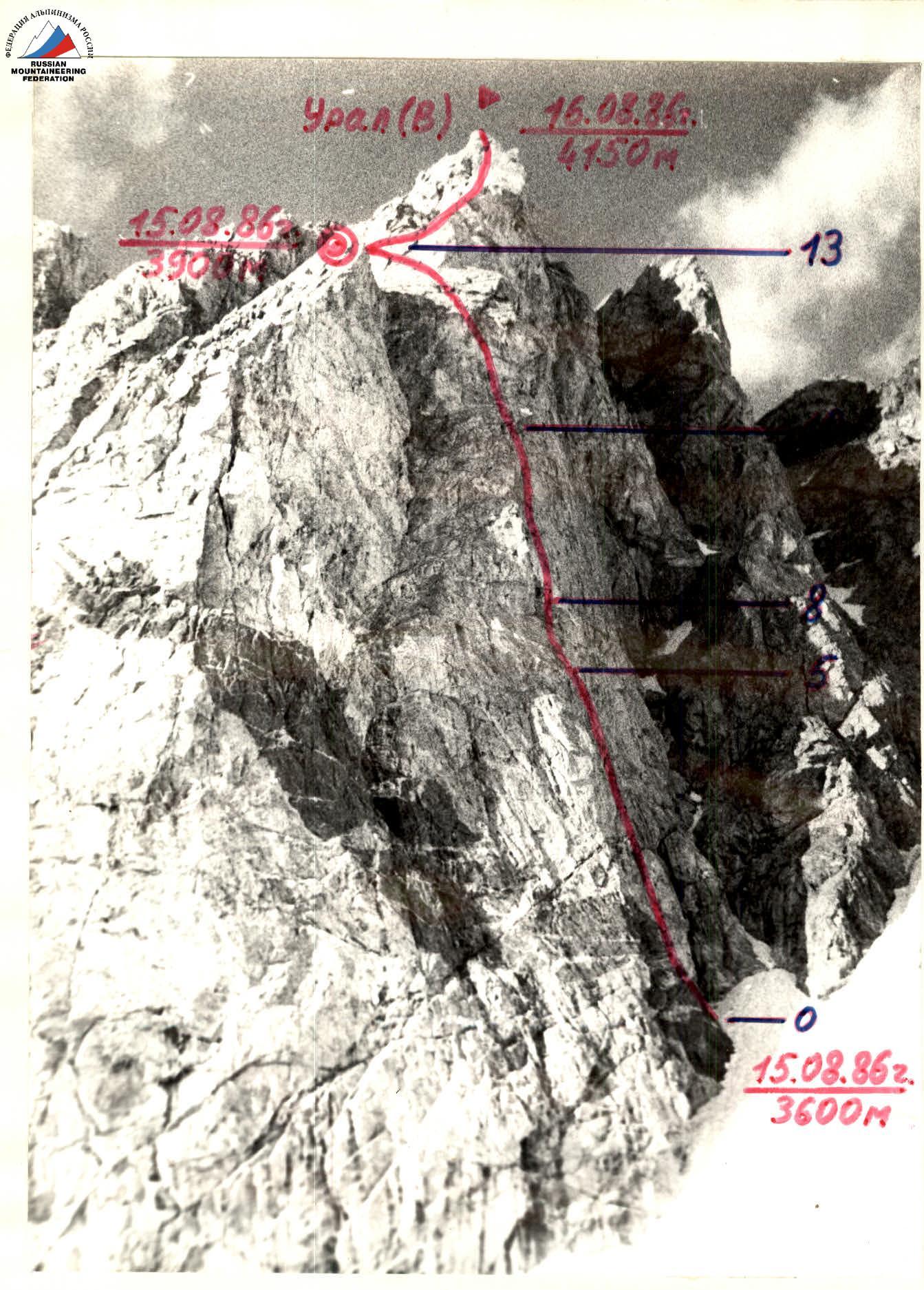
Photo 3. Profile of the wall on the left. August 14, 1986. 18:30. Lens "Helios-89" F=30 mm. Distance - 200 m. Shooting point - 3. Height of shooting point - 3500 m.
In 1982, a team from the All-Union School of Instructors of Mountaineering (led by Ivanov N.R.) first ascended v. Ural V. via the D-3 wall of the buttress, 5B category of complexity. This route passes between the rock cornices of the ridge and the belt of rock cornices in the middle part of the wall. In 1985, the D-3 wall of v. Ural V. was photographed from the gendarme "Utyug". Studying the photograph and further observation of the wall showed that it is possible to lay a new route on v. Ural V. via the D-3 wall, passing under the rock cornices in the middle part of the wall. In July 1986, the D-3 wall was photographed from the saddle between the gendarme "Utyug" and v. Ullu-auz.
On August 12, 1986, the team ascended v. Ural (3-3), traversed with 3 grade, 4B category of complexity, and studied the descent from the summit to the Ullu-auz gorge. This descent option allows not taking:
- crampons;
- ice axes;
- ice screws.
Team members prepared for the season according to individual plans. In previous seasons, they had ascents with complexity up to 5B category inclusive.
Monolithic rocks make the route non-rockfall-prone. The route is logical and safe. And the "blind" cracks in monolithic rocks, unsuitable for hammering pitons and using chocks, and small, hemispherical holds for hands and feet make it difficult and impractical to deviate from the route.
Considering that the route is rock and the rocks are cold in the morning, and after nighttime snowfalls, the snow does not have time to melt early in the morning, it was decided to start the ascent at 7:00. During the ascent period, the weather was stable, allowing work until 18-19 hours, which was taken into account when drawing up the tactical plan.
The tactical plan was based on:
- the team's physical and technical preparation;
- the specifics of ascending v. Ural V.;
- weather conditions.
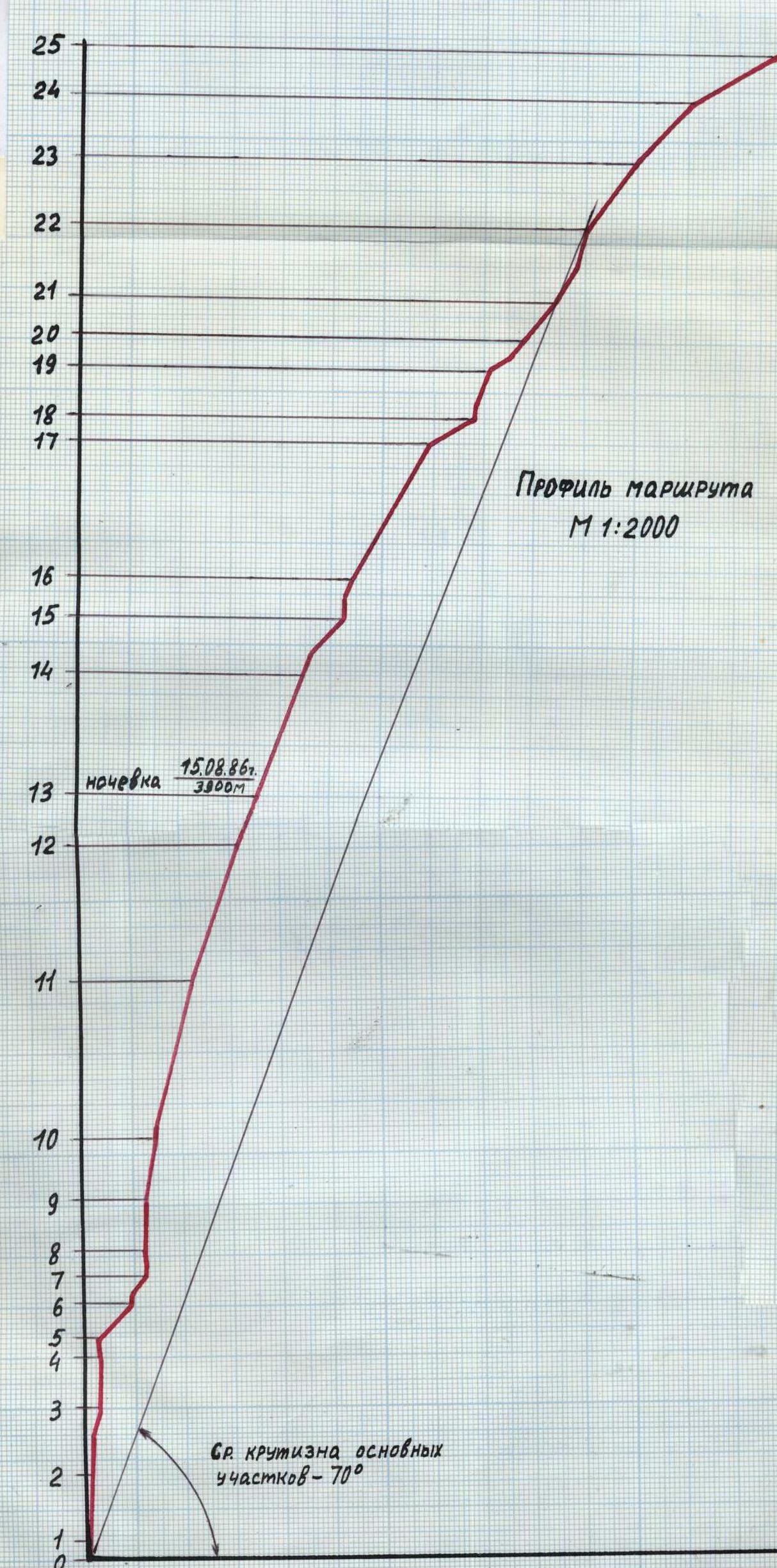
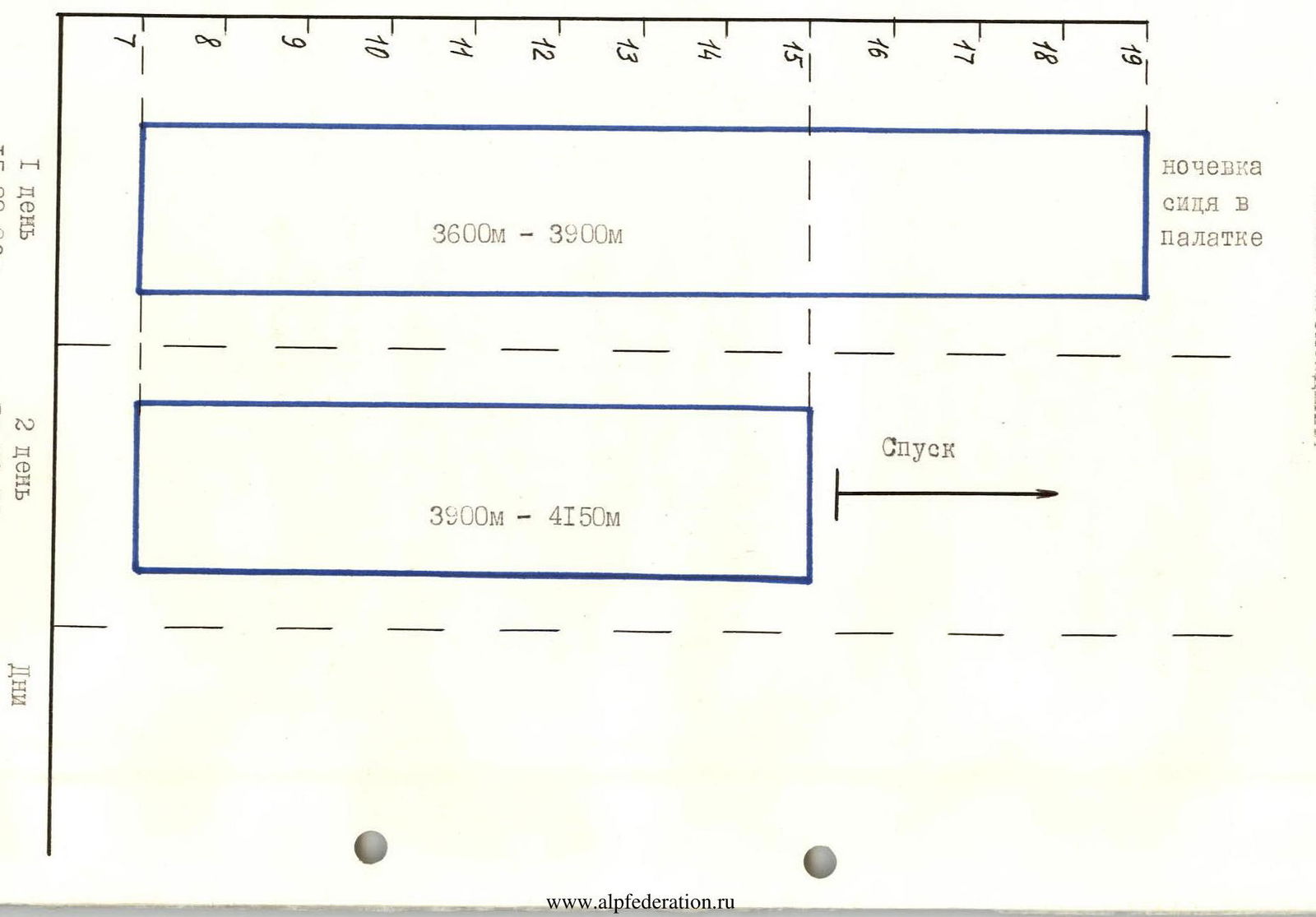
Daily Ascent Hours
Map-Scheme
M 1:50000
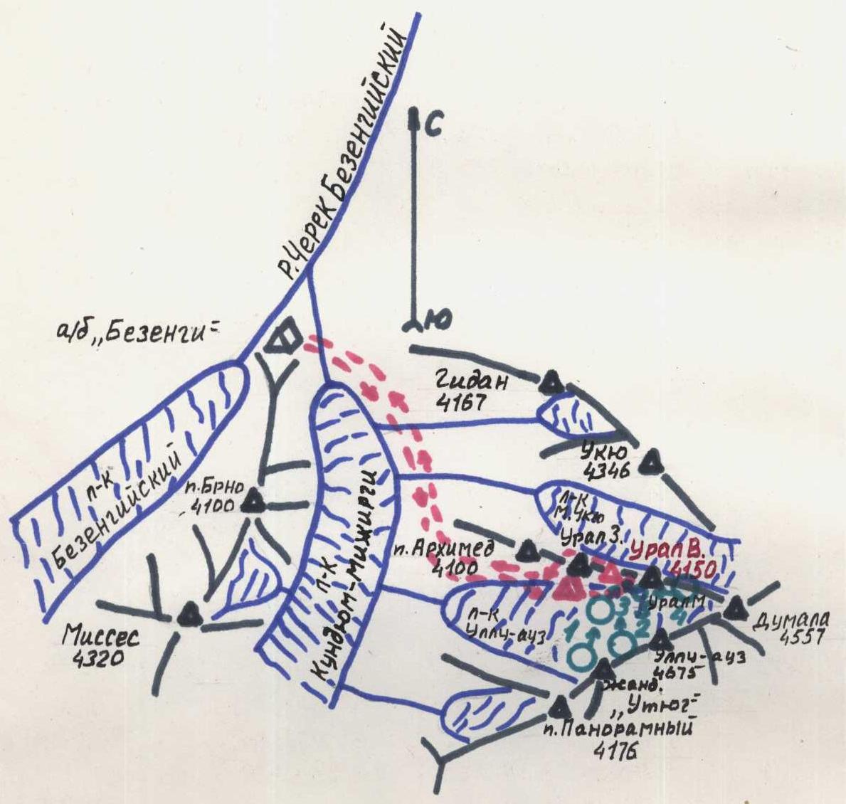
ascent and descent paths
photo shooting points
bivouac under the route
Team's Tactical Actions
The tactical plan provided for completing the route with one overnight stay. In case of bad weather, an additional overnight stay was planned. The strong and even composition of the team allowed them to adhere to the time schedule of the route.
The leader of the first rope climbed with a lightened backpack (with only a down jacket) and on a double rope. On sections with 5-6 category of complexity, safety ropes were used. On less hazardous sections, the ropes moved autonomously (the first rope left pitons for the second). The team worked with standard shock absorbers. On the first day, Efremov V. worked as the leader. On the second day, everyone worked as leaders. Chock stones were widely used.
In the middle of the belt of rock cornices, a logical exit to the main ridge was found. Further movement under the cornices excluded free climbing. The rock relief ("mirrors" of great length) required the use of a significant number of bolt pitons. After the overnight stay, deviating to the right was undesirable due to increased rockfall hazard, as the upper right part of the wall has heavily destroyed sections.
The safety of the route was ensured by:
- Tactical, physical, and psychological preparation;
- Availability of selected equipment;
- Tactical plan;
- Availability of a first-aid kit;
- Stable radio communication via the "Kaktus" radio station with the KSP of the Bezengi region;
- Presence of a rescue team at the "Bezengi" alpine camp.
On the route, 2 meals and a pocket snack were planned. Due to the lack of water at the campsite, the team took 4 liters of water (1 liter per person per day).
The overnight stay was organized on a small site. The overnight stay was sitting, uncomfortable.
There were no falls or injuries.
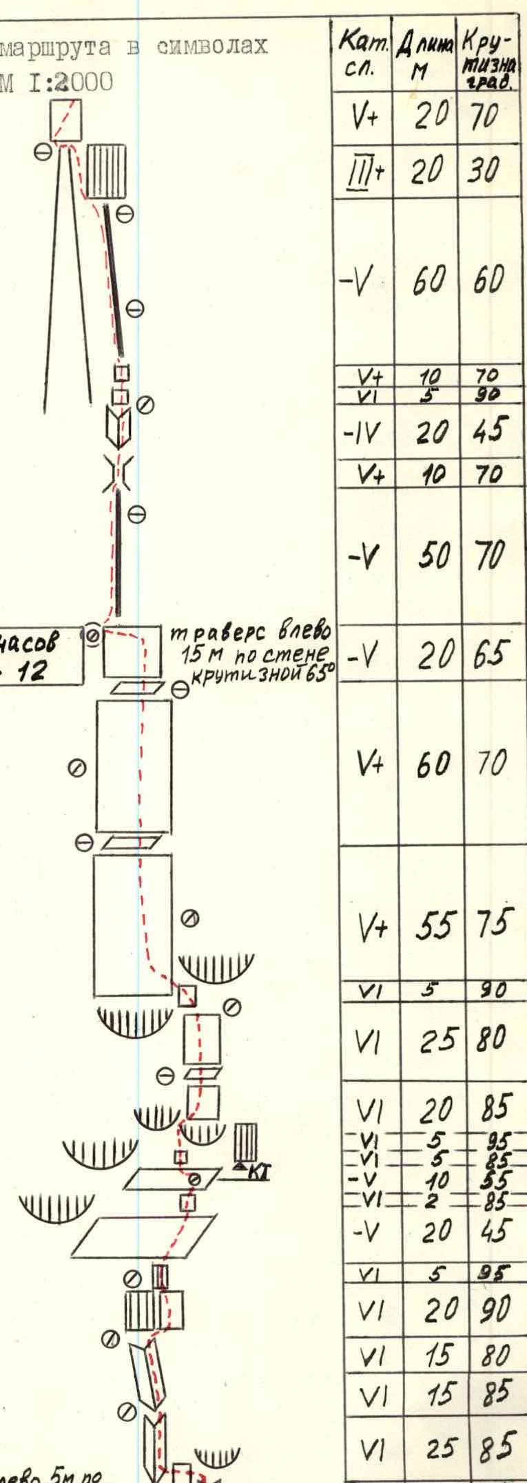
| Section № | Pitons (rock/bolt) | Chocks | Category of complexity | Length (m) | Steepness (°) |
|---|---|---|---|---|---|
| Total | 65/7 | 72/3 | |||
| Man-hours: | Total: 20 | ||||
| per day: 12 | |||||
| R0 | 2 | 6 | 25 | 85 | |
| 6 | 7 | 85 | |||
| R1 | 4 | 4 | 6 | 15 | 85 |
| R2 | 4 | 8 | 6 | 15 | 80 |
| R3 | 2 | 3 | 6 | 20 | 90 |
| R4 | 2/1 | 2/2 | 6 | 5 | 95 |
| R5 | 2 | 5 | 20 | 45 | |
| R6 | 1 | 1 | 5 | 10 | 55 |
| 6 | 5 | 85 | |||
| 5 | 5 | 95 | |||
| R7 | 3 | 2 | 6 | 20 | 85 |
| R8 | 3 | 2 | 6 | 25 | 80 |
| R9 | 3 | 3 | 6 | 5 | 90 |
| R10 | 5 | 6 | 5 | 55 | 75 |
| R11 | 4 | 6 | 5 | 60 | 70 |
| R12 | 41/6 | 40/2 | 5 | 20 | 65 |
| R13 | 3 | 2 | 5 | 50 | 70 |
| R14 | 2 | 1 | 5 | 10 | 70 |
| 4 | 20 | 45 | |||
| R15 | 3 | 2 | 6 | 5 | 90 |
| 5 | 10 | 70 | |||
| R16 | 3 | 4 | 5 | 60 | 60 |
| R17 | 2 | 3 | 20 | 30 | |
| R18 | 2 | 2 | 5 | 20 | 70 |
| Total per day | |||||
| 24/1 | 32/11 | Man-hours per day: 8 | |||
| R19 | 2 | 1 | 3 | 10 | 30 |
| 5 | 10 | 55 | |||
| R20 | 3 | 4 | 20 | 50 | |
| R21 | 3 | 5 | 5 | 15 | 60 |
| 5 | 15 | 75 | |||
| R22 | 3 | 3 | 5 | 35 | 55 |
| R23 | 2 | 3 | 4 | 30 | 45 |
| R24 | 2 | 3 | 40 | 30 | |
| R25 | 24/1 | 32/11 |
Description of the Route by Sections
1st day. August 15, 1986.
Section R0–R1
The route starts 5 m above the point where the white stripe in the belt of black rocks meets the snow.
- An inner corner leads to an overhanging rock (see photo 5). 7 m, 85°, 6.
- From the overhanging rock - traverse left 5 m along a narrow inclined ledge to the start of an inner corner (see photo 6). 5 m, 85°, 6.
The traverse is done on balance. The rocks are monolithic perspective, there are few holds. Climbing is tense. There is a heavy load on the hands.
Section R1–3
A series of inner corners, separated by narrow ledges suitable for organizing belay points. Movement is upwards, under the overhanging "rusty" wall (see photo R11–R12). 15 m, 85°, 6; 15 m, 80°, 6.
Section R3–5
The "rusty" wall is bypassed from left to right. Further upwards, to the overhanging wall. The wall is climbed using aid climbing. 20 m, 90°, 6; 5 m, 95°, 6.
Section R5–6
Along a smooth inclined slab to the right towards a steep wall. Climbed on friction. 20 m, 45°, 5.
Section R6–7
The steep wall is climbed using free climbing. 2 m, 85°, 6. Exit to the second smooth inclined slab. 10 m, 55°, 5. Climbed on friction. On the slab, a bolt piton is hammered to organize belay, and a control cairn is left on it.
Section R7–8
From the control cairn to the left towards the wall under the cornice. Up the wall under the cornice. 5 m, 85°, 6. The cornice is passed using aid climbing (see photo R14–R16). 5 m, 95°, 6. There are few cracks suitable for hammering pitons and using chocks.
Section R8–10
Above the cornice, a series of walls leads to the middle part of the belt of rock cornices. Steep. The rocks are monolithic. Holds are small, climbing is difficult. There is a heavy load on the hands. 20 m, 85°, 5; 25 m, 80°, 6.
Section R10–11
Through a short but steep wall, exit to the main ridge. 5 m, 90°, 6. Climbing is tense. After the wall, movement is upwards, above the belt of cornices. Holds are small, friction is good. 55 m, 75°, 5.
Sections R11–R13
A series of monolithic rocks. 60 m, 70°, 5; 20 m, 65°, 5. Further, traverse left (15 m along a wall with a steepness of 65°, 5) in the direction of the ridge on the left. Here is the overnight stay. The ledge is small, the overnight stay is sitting, uncomfortable.
2nd day. August 16, 1986.
Sections R13–R15
Along the monolithic rocks of the ridge, holding to the left side, upwards to a chimney. 50 m, 70°, 5. The chimney leads to an inner corner. The rocks of the chimney are wet, smooth. Climbing is difficult. Further along the inner corner. 10 m, 70°, 5; 20 m, 45°, 4.
Section R15–R16
- A steep wall is smooth, climbed using aid climbing. 5 m, 90°, 6.
- Then to the right along a 10-meter wall. 10 m, 70°, 5.
Sections R16–R19
- Along the ridge, going along the couloir to the overhanging wall. 60 m, 60°, 5.
- The overhanging wall is bypassed to the left upwards, crossing the couloir at its base.
- Then along the wall from left to right.
- Exit to a ledge. 20 m, 70°, 5.
Sections R19–R21
Along the ledge to the left to an inner corner leading to the ridge. Along the ridge to the wall. 10 m, 30°, 3; 10 m, 55°, 5; 20 m, 50°, 4.
Sections R21–R23
Along the wall and further along the inner corner - exit to the ridge. The rocks are monolithic, dry, holds are small. The ridge leads to a wall. 15 m, 60°, 5; 15 m, 75°, 5; 35 m, 55°, 5.
Sections R23–Rsummit
Upwards along the wall. Exit to a ledge and then along the ridge - exit to the summit. 30 m, 45°, 4; 40 m, 30°, 3.
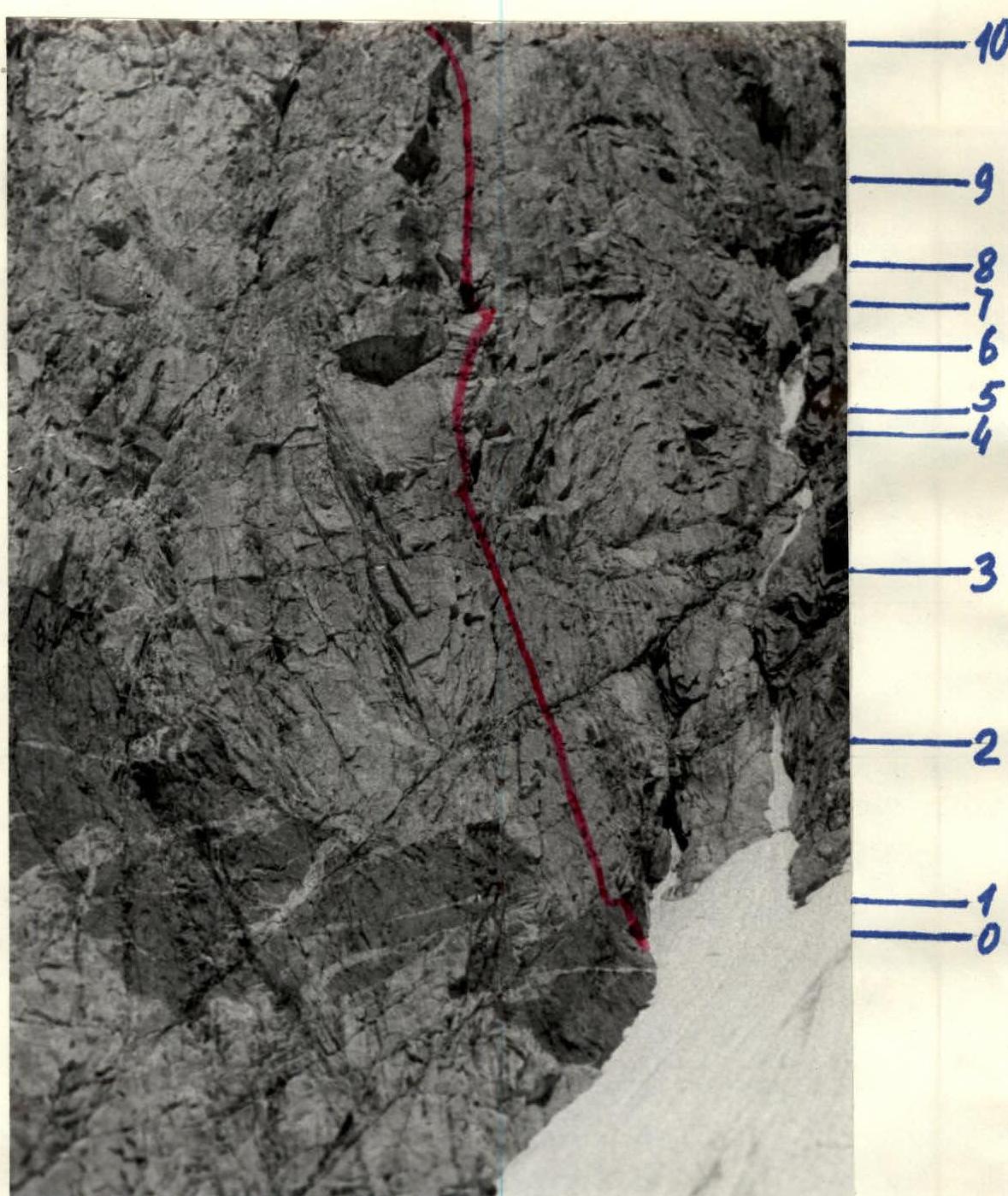
Photo 4. Technical photograph of the route (sections R0–R10). August 14, 1986. 18:30. Lens "Helios-89": F=30 mm. Distance - 150 m. Shooting point - 6 (see photopanorama of the area). Height of shooting point - 3580 m.
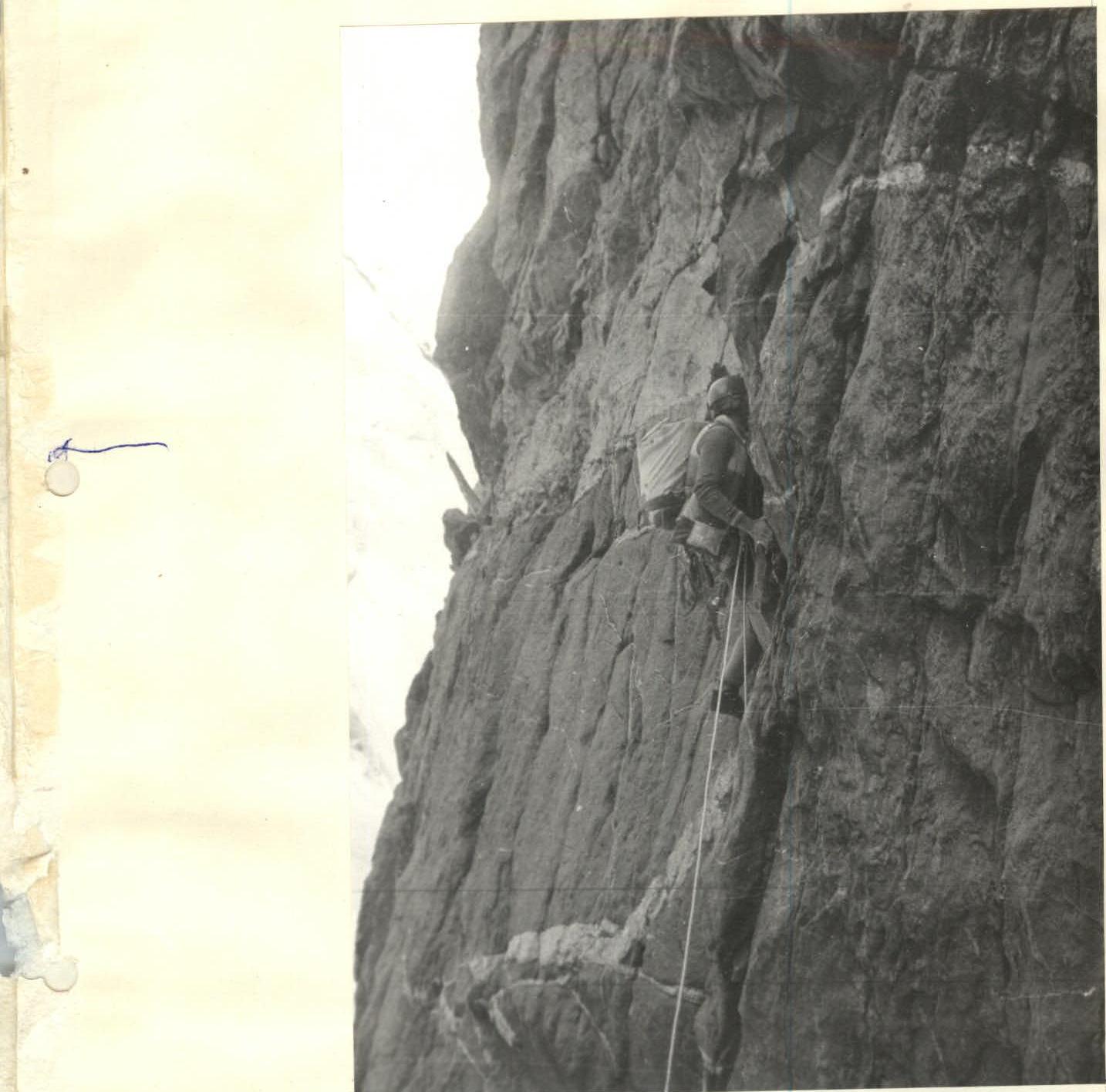
Photo 5. Section R0–R1. Climbing the inner corner first. Lens "Helios-89": F=30 mm. Distance - 20 m. Shooting point - 5. Height of shooting point - 3600 m.
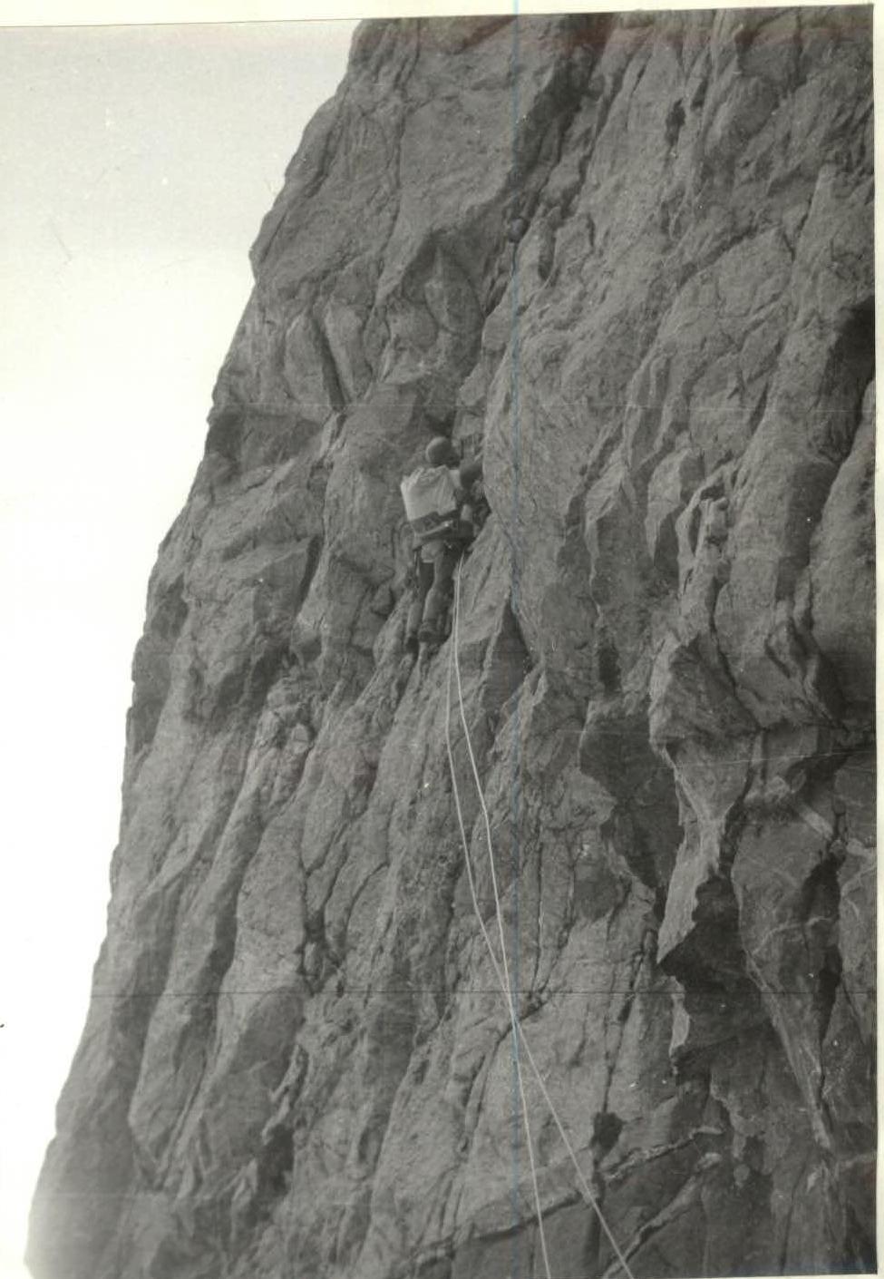
Photo 8. Section R1–R2. Climbing the inner corner. Lens "Helios-89". F=30 mm. Distance - 40 m. Shooting point - 5. Height of shooting point - 3600 m.
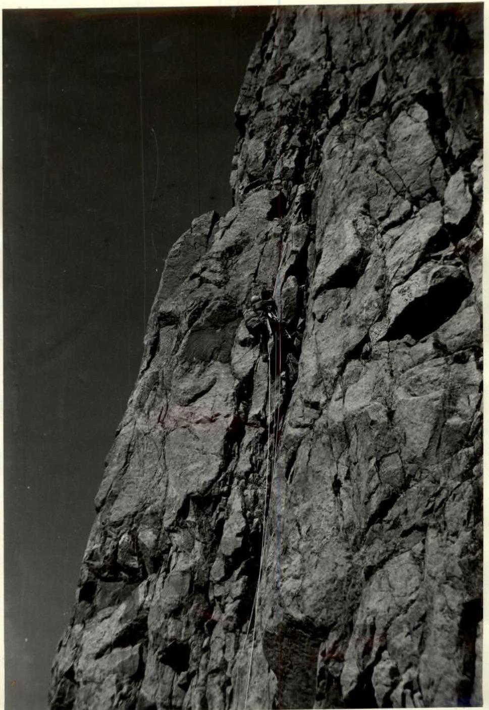
Photo 10. Section R1–R2. Climbing the upper part of the inner corner on safety ropes. Lens T-22. F=40 mm. Distance - 50 m. Shooting point - 5. Height of shooting point - 3600 m.
Photo 12. View of sections R2–R4. Lens "Helios-89".
F=30 mm
At the top - the belt of rock cornices in the middle part of the wall.