Climbing Passport of Voskoboev and Orlov
- Climbing category: 2B
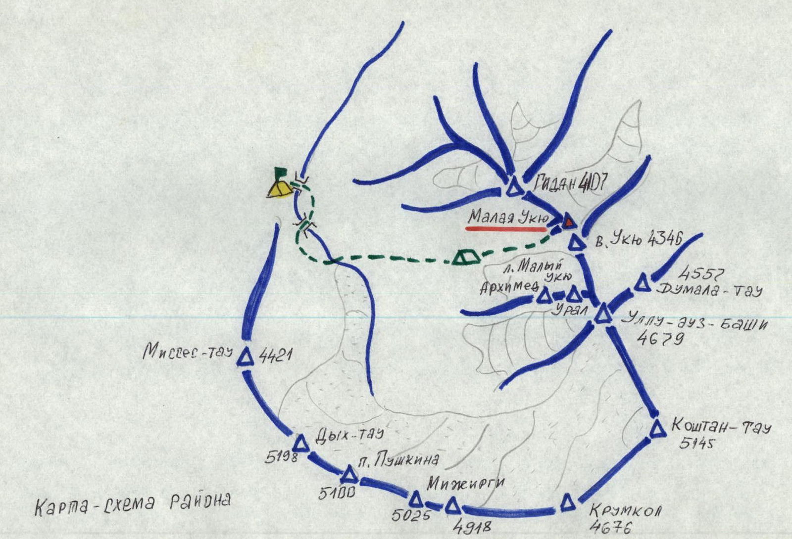
- Climbing area: Caucasus, North spur of Ukru
- Peak: Malaya Ukyu, via rock counterfort
- Proposed category difficulty: 2B
- Character: rocky; elevation gain: 460 m, average steepness: 35°, length: 620 m
- Pitons driven for protection: rock 6, ice –, used chocks 1
- Movement time: 9.5 hours
- Number of nights: –
- Participants: Gashnogo V.N. — 1st category — leader, Koshevnick B.L. — MS — member, Stepanov E.P. — CMS, Naranenko V.L. — 1st category, Meshalkin N.P. — 1st category, Konin M.M. — 1st category, Danichkina L.G. — 1st category
- Team coach: Honored Coach of the RSFSR Zhirnov V.V.
- Date of departure and ascent: August 8, 1979
Brief description of the approach to the route
From the Bezengi alpine camp along the trail to the bridge over the Mizhirgi River, then up the trail on the left bank of the Mizhirgi River.
The first stream flowing from the spur passes under a bridge.
Further up the trail to the moraine. Along the trail — traverse the moraine on its left side.
Through grassy slopes and talus on the left side of the stream (second along the route) ascent to a green meadow. The meadow is located under the Maly Ukyu glacier.
Bivouac on the meadow. From the meadow up to the depression in the terminal moraine. Then along the right-bank moraine and talus, bypassing a rock island on the right.
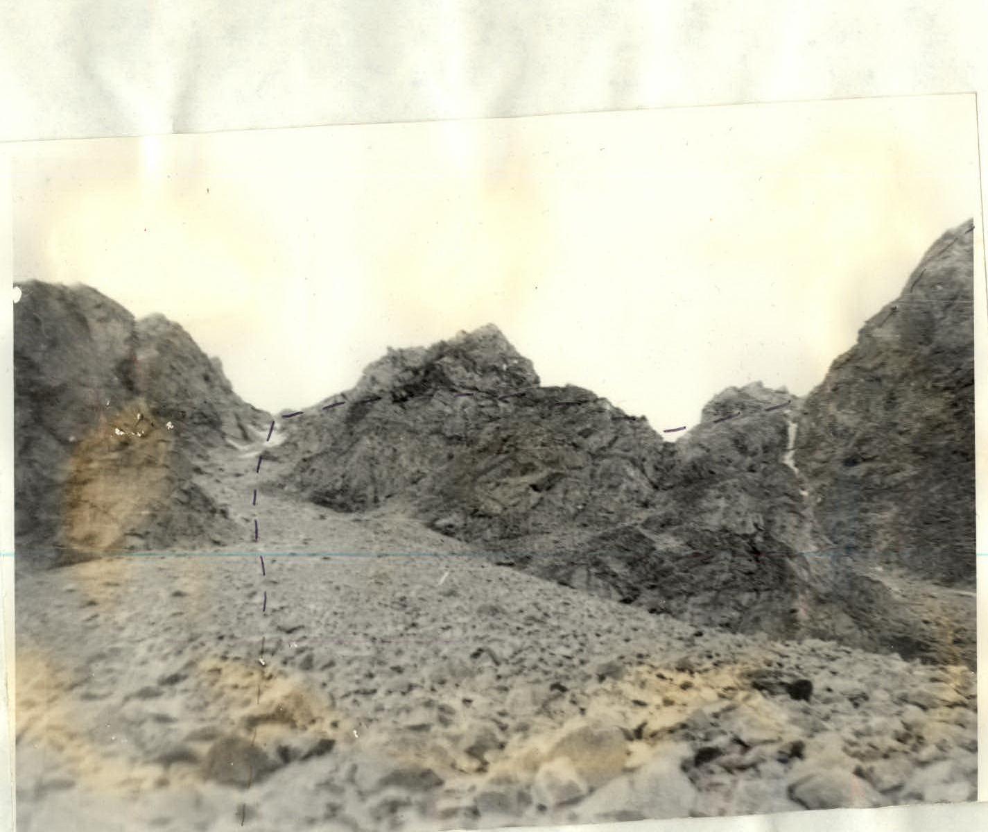
The rock counterfort, through which the route passes in its lower part, is a solid ridge, and in its upper part consists of several rock counterforts converging into one above, which leads directly to the summit of Malaya Ukyu. The lower solid part of the counterfort is easily bypassed along the talus on the left side.
The route begins below the start of the lateral counterforts and above a characteristic ledge on the left side of the counterfort.

Main characteristics of the route
| Section | Steepness | Length | Relief character | Difficulty | Condition | Weather conditions | Rock pitons | Ice pitons | Chocks |
|---|---|---|---|---|---|---|---|---|---|
| R0–R1 | 40–45° | 60 m | rock-ice couloir | 3A | destroyed rocks, ice | good | – | – | – |
| R1–R2 | 30–35° | 70 m | ledges, inner corner | 3B | destroyed rocks | good | – | – | – |
| R2–R3 | 70–75° | 40 m | wall | 4A | monolith | good | 3 | – | – |
| R3–R4 | 45–50° | 50 m | narrow gully | 3B | monolith | good | 1 | – | – |
| R4–R5 | 30–35° | 40 m | rocky slope | 3A | destroyed rocks | good | – | – | – |
| R5–R6 | 30° | 30 m | slab, monolithic rocks, ledges | 3A | monolith | good | – | – | – |
| R6–R7 | 50° | 40 m | rocks | 3B | monolith | good | – | – | – |
| R7–R8 | 15° | 260 m | ridge | 2A | destroyed rocks | good | – | – | – |
| R8–R9 | 50° | 60 m | inner corner | 3B | destroyed | good | 2 | – | 1 |
| R9–R10 | 45° | 40 m | destroyed rocks | 3A | destroyed rocks | good | – | – | – |
| R10–R11 | 50° | 40 m | destroyed rocks | 3A | destroyed rocks | good | – | – | – |
| R11–R12 | 20° | 200 m | ridge | 2A | snowy | good | – | – | – |
Explanation of the table
- R0–R1: From talus, ascent through rocks of medium difficulty (loose rocks?) via a wide inner corner with ice in the middle part. Exit to a shoulder in the counterfort ridge. Control cairn. Easy rocks bypassing the wall on the right.
- R1–R2: Talus ledges – 15 m. Rocks of medium difficulty, ice-covered – 20 m. Talus depression. Inner corner — gully, divided by a small rock ridge into two gullies — the right one is ice-filled. Movement through the left gully (loose rocks). Rightward through snow — under a cornice — 10 m.
- R2–R3: Then leftward exit to a large ledge. Ascent to a gendarme directly — wall. Rocks more difficult than average. Pitons used for protection.
- R3–R4: Leftward and upward through a less distinct gully. Difficult rocks. Alternating piton protection. Exit to a wide ledge — easy rocks 10 m.
- R4–R5: From the ledge leftward bypassing a gendarme. Rocks of medium difficulty. Protection through outcrops. Exit to a gendarme. On the gendarme — a control cairn.
- R5–R6: Further on, a slab 5 m. Exit along the edge of the slab and on the left side. Rocks of medium difficulty, monolithic. Wide ledges.
- R6–R7: Ascent through a curving chimney with wedged rocks. Monolithic rocks, alternating piton protection.
- R7–R8: Wide ridge 20 m. Descent from the ridge rightward and bypassing the ridge on the right along talus ledges — 200 m. Simultaneous movement.
- R8–R9: Ascent through a destroyed inner corner. Loose rocks. Piton protection. Exit to a saddle on the ridge.
- R9–R10: From the saddle, bypassing the ridge on the left. Destroyed rocks. Exit to an inclined talus ledge.
- R10–R11: From the ledge, bypassing the ridge on the left. Destroyed rocks. Alternating protection through outcrops.
- R11–R12: Destroyed snowy ridge. 200 m. Simultaneous movement. Summit.
Descent from the Malaya Ukyu summit in the direction of the Gidanta peak along a snow-firn slope with rock outcrops to a saddle between the left ridge and the central counterfort. From the saddle — down a talus gully with ice in the middle part.
Then along the right-bank orographic moraine of the Maly Ukyu glacier and along the trail to the lower camps in the Ukyu valley.
Ascent from the lower camps in the Ukyu valley to the start of the route takes 2 hours. Ascent from the start of the route to the summit takes 6 hours. Descent from the summit to the lower camps in the Ukyu valley takes 2 hours. The entire route takes 10 hours.
Descent from the summit.