Ascent Passport
-
Ascent category: rock climbing
-
Ascent area: Caucasus, Bezengi, Northern spur of the Main Caucasian Range
-
Peak: Malaya Ukyu (4240 m) via the left southern counterfort
-
Proposed category of difficulty: 3A
-
Route characteristics: height difference — 450 m, average steepness — 33°, section lengths:
- 2A — 150 m
- 2B — 170 m
- 3A — 330 m
- 3B — 207 m
- 4A — 20 m
-
Pitons used:
Type For belay For creating Intermediate Technical Obstacles Rock 3 – Bolt – – Ice – – Chocks – – -
Total climbing time: 8.5 hours
-
Number of overnight stays: –
-
Participants:
- Shchepak S.V. — team leader
- Darmin E.N. — 1st sports category
- Tyulpanov S.S. — Master of Sports
- Abalymova L. — 1st sports category
- Mavrichev B.D. — 1st sports category
- Ostrogorsky — 1st sports category
-
Team coach: Honored Coach of the RSFSR — Zhirnov V.V.
-
Date of ascent: August 3, 1979
Explanation of the table
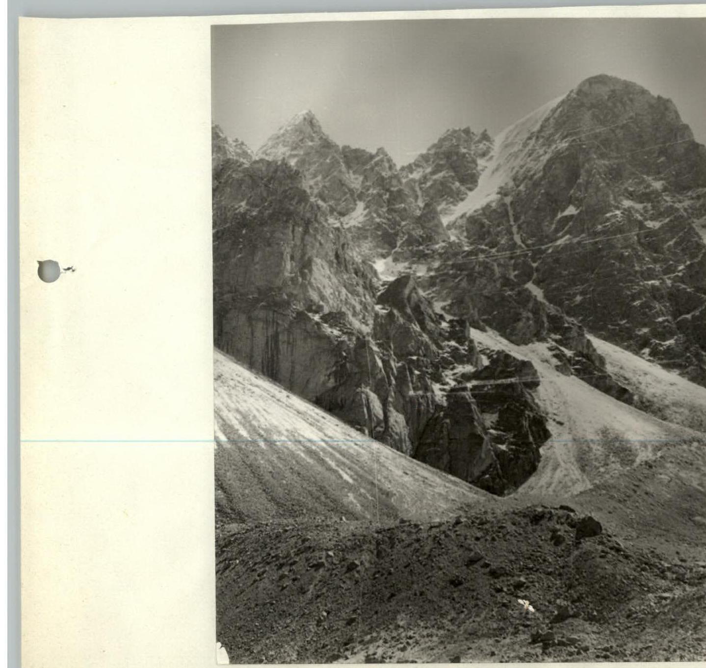
- R0–R1 (40–45°, 120 m): From the Malaya Ukyu glacier, we ascend via the first snow-ice couloir that leads to the ridge. 50 m before reaching the ridge, we move left onto broken rocks.
- R1–R2 (50–55°, 50 m): We ascend via broken rocks and then a 3-meter internal corner to reach the ridge. Belay is alternating.
- R2–R3 (20–25°, 50 m): On the ridge, there was a cairn. From the cairn, we move left along the ridge with simultaneous belay and approach a gendarme.
- R3–R4 (70–75°, 7 m): The gendarme is bypassed on the right by overcoming a 7-meter wall. Belay is alternating with rope placement around protrusions and using piton belay.
- R4–R5 (30–35°, 160 m): Further along the gendarme via a rock ledge, placing the rope around protrusions, movement is simultaneous, and we reach a wide ledge above which a slab rises.
- R5–R6 (70–75°, 20 m): To the left of the slab, there is a crevice. We ascend via it using piton belay and reach broken rocks.
- R6–R7 (50–55°, 50 m): Via broken rocks with alternating belay, we reach a saddle between a double-toothed gendarme. On the saddle, there is a control point.
- R7–R8 (20–25°, 120 m): From the control point, the pre-summit gendarme is bypassed on the right via broken rocks (simultaneous belay), and we reach a gentle pre-summit ridge.
- R8–R9 (15–20°, 150 m): Via snow, we approach the summit ascent.
- R9–R10 (40–45°, 120 m): To the summit, we ascend via the left snow-ice couloir with an exit left onto broken rocks. Belay is alternating using rock protrusions. Via broken rocks, we reach the summit.
Descent from the summit follows the ascent path down to the snowy pre-summit ridge, then from the pre-summit gendarme left via broken rocks down into a couloir, and via it down into the Ukyu gorge.
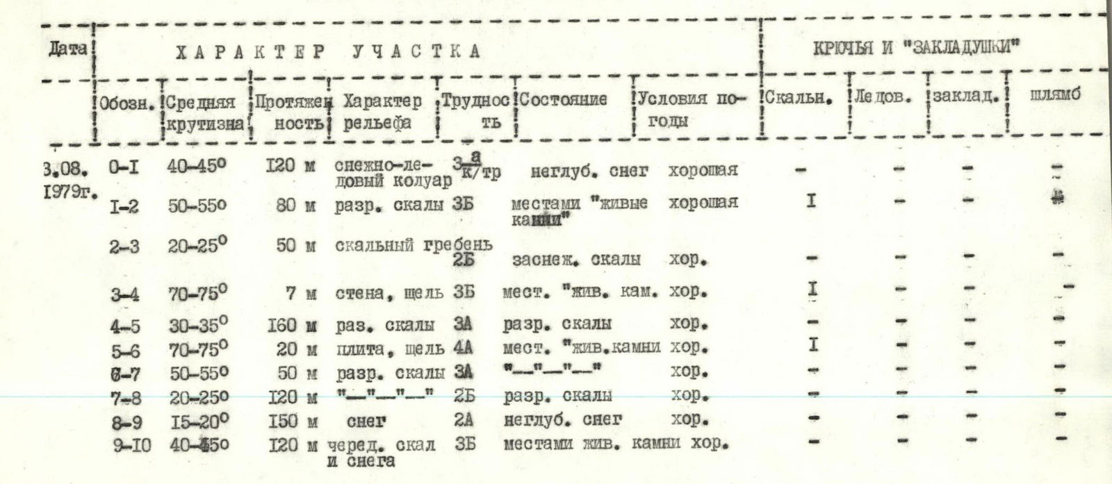
Main characteristics of the route
| Date | Designation | Average steepness | Length | Terrain characteristics | Category of difficulty | Condition | Weather conditions | Rock pitons | Ice pitons | Chocks | Bolt pitons |
|---|---|---|---|---|---|---|---|---|---|---|---|
| 3.08.1979 | R0–R1 | 40–45° | 120 m | snow-ice couloir | 3 | shallow snow | good | – | – | – | – |
| R1–R2 | 50–55° | 80 m | broken rocks | 3 | местами «живые камни» | good | 1 | – | – | – | |
| R2–R3 | 20–25° | 50 m | rocky ridge | 2 | snowy rocks | good | – | – | – | – | |
| R3–R4 | 70–75° | 7 m | wall, crevice | 3 | local «live rocks» | good | 1 | – | – | – | |
| R4–R5 | 30–35° | 160 m | broken rocks | 3 | broken rocks | good | – | – | – | – | |
| R5–R6 | 70–75° | 20 m | slab, crevice | 4 | local «live rocks» | good | 1 | – | – | – | |
| R6–R7 | 50–55° | 50 m | broken rocks | 3 | --- | good | – | – | – | – | |
| R7–R8 | 20–25° | 120 m | broken rocks | 2 | broken rocks | good | – | – | – | – | |
| R8–R9 | 15–20° | 150 m | snow | 2 | shallow snow | good | – | – | – | – | |
| R9–R10 | 40–45° | 120 m | alternating rocks and snow | 3 | local live rocks | good | – | – | – | – |
Route recommendations
- To take on the route:
- a pair of crampons
- 3 ice axes (ice is possible)
- Possible bivouac sites: After the 2nd control point, before the summit ascent — a wide snowy area.
Brief description of the approach to the route
From the Bezengi alpine camp, follow the trail to the bridge over the Mizhirgi River, then up the trail on the left bank of the Mizhirgi. The first stream flowing from the spur is crossed via a bridge. Further up the trail, traverse the moraine on its left side. Via grassy slopes and scree on the left side of the stream (second on the route), ascend to a green meadow under the Maly Ukyu glacier. On the meadow, there is a bivouac site.
From the meadow:
- left, in the depression of the terminal moraine;
- then again left-up via scree, ascend to the moraine in front of the left southern counterfort of Malaya Ukyu.
Descending from the moraine, we approach a snowy couloir.