I. Description of the Traverse Route
I. General Description of the Traverse of Ukyu and Gidan-tau Peaks and their Location
In the central part of the Central Caucasus, in the area of the Bezengi valley, north of Koshtan-tau peak, a spur of the Lateral Range extends, with Ullu-auz-bashi peak located in its northern part.
Northeast of Ullu-auz-bashi peak lies Dumala-tau peak, opposite which, to the northwest, is a spur with Ukyu and Gidan-tau peaks.
The spur with Ukyu and Gidan-tau peaks belongs to the Dumala river valley, which flows into the Cherek Bezengiysky river on the right. (see map)
The traverse of Ukyu-Gidan-tau peaks was started from the "Bezengi" alpine camp following the route described in "Ascent to Ukyu peak via the southeastern ridge, category 2B".
The further traverse proceeded in a northwest direction to Gidan-tau peak, with a descent along the western ridge of Gidan-tau peak.
Having started the route at 4:00 PM on August 6, 1963, the group of 6 people:
- Minin V.P. - leader, 1st sports category.
- Mekhannikov V.V., 1st sports category.
- Pokrovsky A.M., 1st sports category.
- Tretyakova T.B., 1st sports category.
- Saratov Yu.S., 1st sports category.
- Minin V.P., Master of Sports.
was forced to wait out bad weather at "Green Glade" under Ukyu peak for a day. On August 8, 1963, at 5:00 AM, they started the traverse, which ended at "Bezengi" alpine camp on August 10, 1963, at 11:00 AM. (see traverse diagram of Ukyu-Gidan-tau peaks)
2. Description of the Route by Sections
Ascent to Ukyu peak via the southeastern ridge, category 2B.
The descent from Ukyu peak along the northern ridge consists of two snow slopes, 50m and 80m long, with a steepness of 45-50°. (see photo 1)
The descent ends at a snow saddle (4100m), where an overnight stop is possible. Next is a gendarme with steep rock faces dropping down to the saddle. (see photo 2)
The ascent to the gendarme is made from the right side via a snow patch, then traversing the rocks towards a couloir, and exiting onto its ridge. Climbing is of moderate difficulty, with protection via ice axe and ledges.
With alternate protection, the group traverses the narrow ridge of the gendarme and approaches its descent.
Directly ahead is a steep (70°) couloir with heavily snow-covered rocks. The descent proceeds down to the right via a steep (60-65°) rocky couloir (30m), composed of slabs with few handholds, to a ledge that goes left and is covered with rocks. Then the path goes under a wall, at the junction of a steep (60°-65°) snow patch, under which is ice, and rocks.
With piton protection, cutting steps (or using front points of crampons), the group traverses the slope (30m) under the rocky wall of the gendarme to a snow patch (30-40°) and descends to a snow saddle. (see photo 3). (An overnight stop is possible).
From the snow saddle, they ascend to the Saw directly ahead via rocks of above-average difficulty. They ascend to the first gendarme of the Saw. (Cairn). Climbing is complicated by the fact that the ridge is heavily snow-covered, and small cornices pose a significant danger. The second gendarme of the Saw is bypassed via a ledge on the right (approximately to the middle, 80-100m), then via a rocky wall (15m) up to the saddle of the gendarme, and further along the ridge to the top of the second gendarme of the Saw. (Cairn).
The route from the top of the second gendarme of the Saw directly along the ridge is not visible, as the gendarme drops with a 20-meter overhanging wall. One should descend to the right via steep rocks (30m) of above-average difficulty, and then left via a ledge to exit onto the ridge.
Having traversed the ridge for 50-60m, they exit onto a narrow snow saddle and then ascend to the top of the third gendarme of the Saw, which drops with a steep (60-70°) rocky wall 50m high. Descent via rappel to the left of the rocky couloir via heavily broken rocks.
The Saw is a heavily serrated narrow ridge with many gendarmes, steeply dropping to the west.
Further:
- steep (40-45°) snow ridge (60m);
- exit onto несложные скалы;
- exit onto a saddle before the ridge of Gidan-tau peak.
Overnight stop.
The path from the saddle to Gidan-tau peak (see photo 4) begins with simple, местами заснеженных, скал южного гребня.
The snow cover on the ridge сильно затрудняет передвижение. The route exits to a rocky slab (6m), which is climbed in its middle part via friction. Further via rocks of moderate difficulty, they approach under a vertical wall (5-6m). (see photo 5).
The wall is overcome with piton protection via a crack. Subsequent gendarmes of the ridge are passed head-on. Then via rocks of moderate difficulty, they exit onto Gidan-tau peak.
The descent from the summit proceeds via the ascent route to the western ridge of Gidan-tau peak (100m). Having exited onto the western ridge, to the left, a несложный снежный кулуар is visible, via which they descend to the "green glade" under the Ukr glacier.
The group believes that the described route, which proceeds on average at an altitude of 3500-4100m, provides an opportunity for full acclimatization in the challenging Bezengi region and gives the group the right to undertake ascents of higher difficulty categories, as well as longer traverse routes.
The traverse of Ukyu-Gidan-tau peaks is a first ascent and is submitted by the group to the classification commission for approval.
Based on the experience of previous ascents, the group considers that the traverse of Ukyu-Gidan-tau peaks should be classified as category 4B.
The ascent to Gidan-tau peak, via the group's descent route, can be classified separately and evaluated as category 3B.
GROUP LEADER TRAVERSE UKYU-GIDAN-TAU /Minin V.P./ December 5, 1963
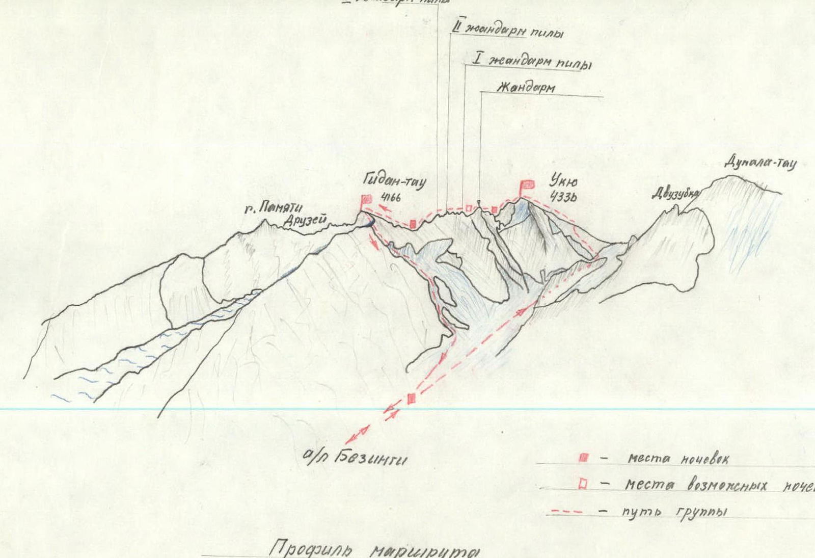
Route Profile
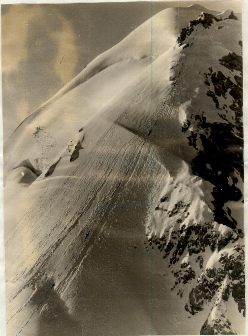
Photo 1. Descent from Ukyu peak
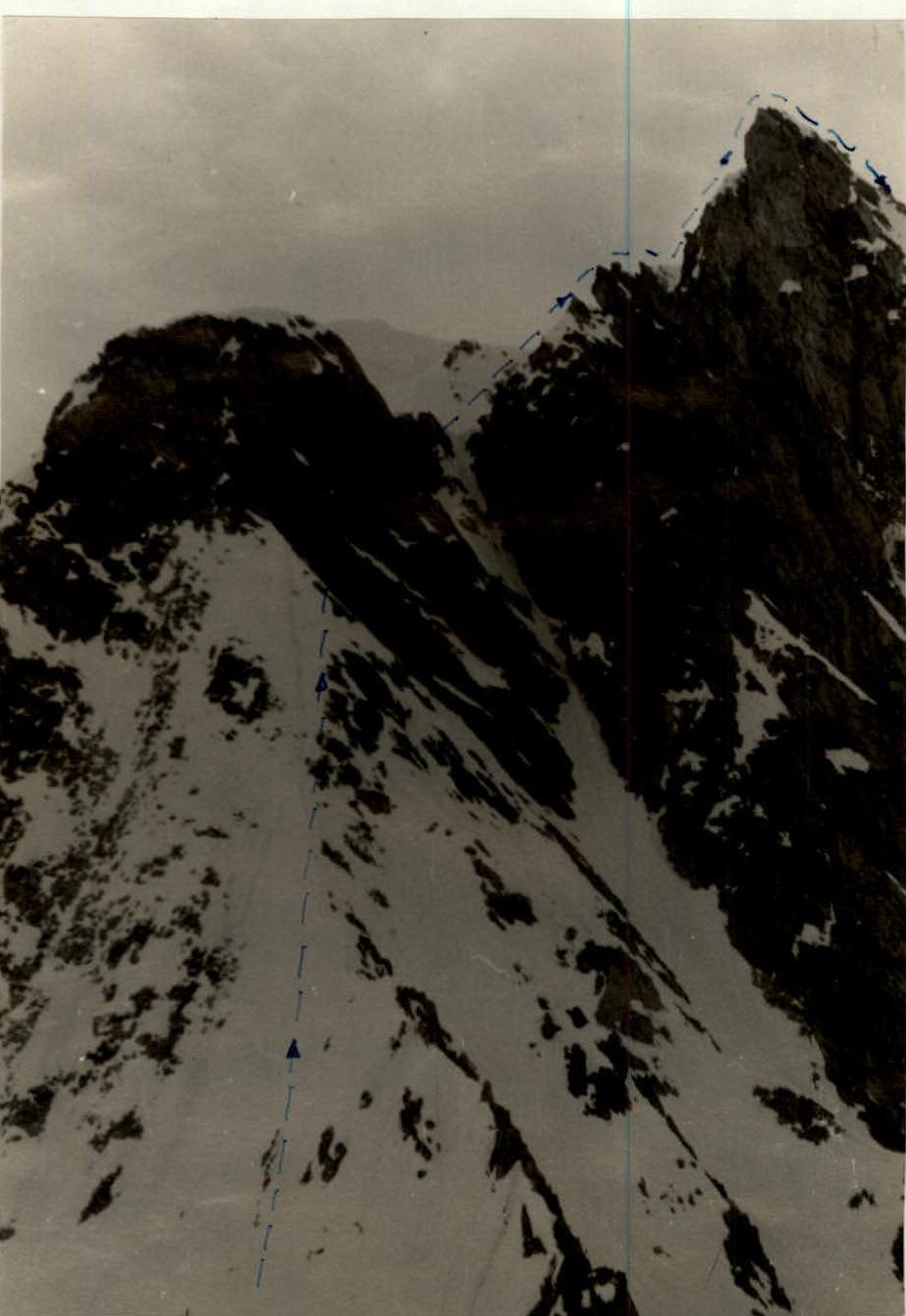
Photo 2. Ascent to the gendarme
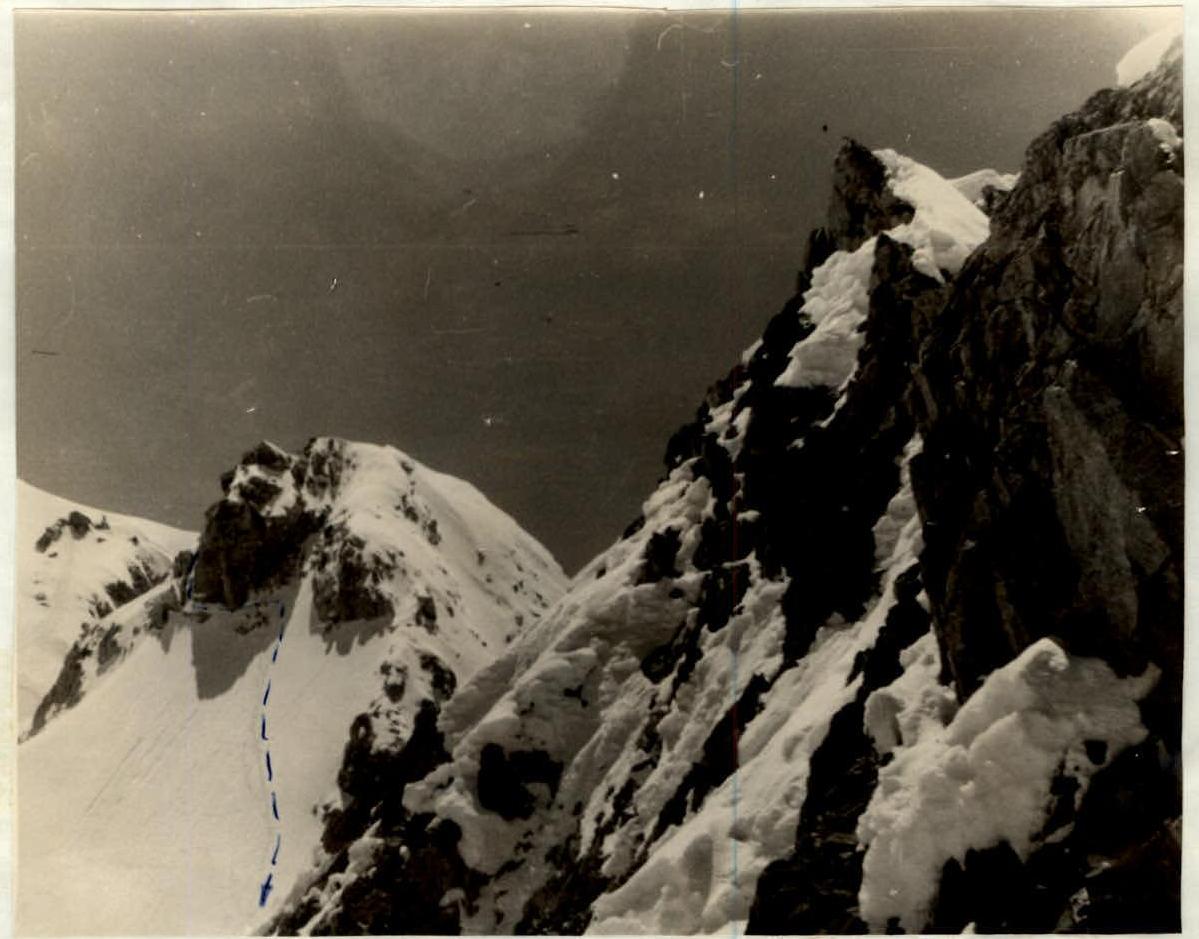
Photo 3. Descent from the gendarme
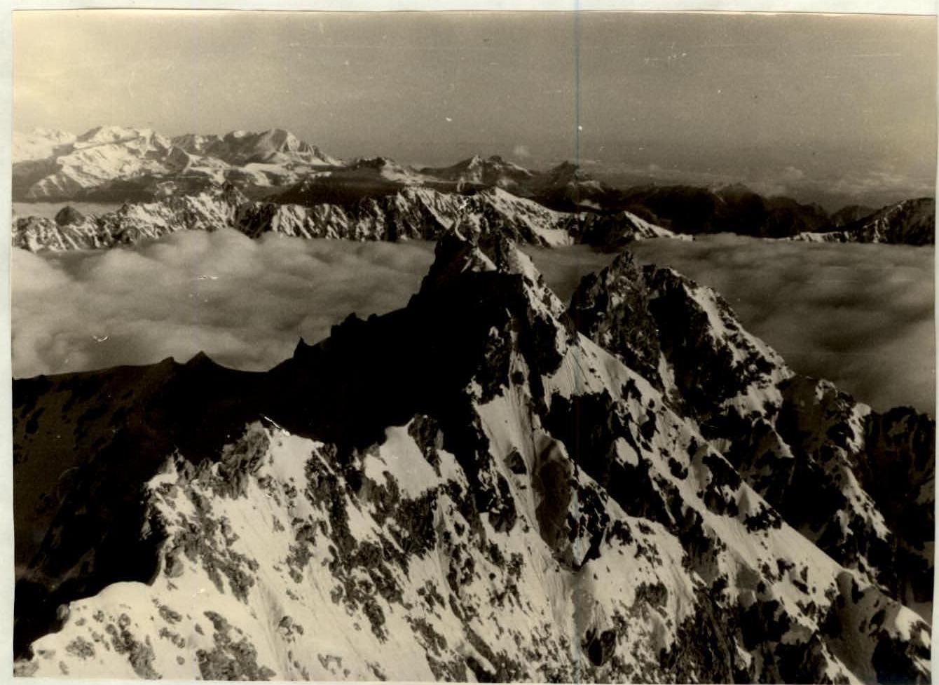
Photo 4. Ridge to Gidan-tau peak