Ascent Passport
- Ascent category — ice-rock (combined)
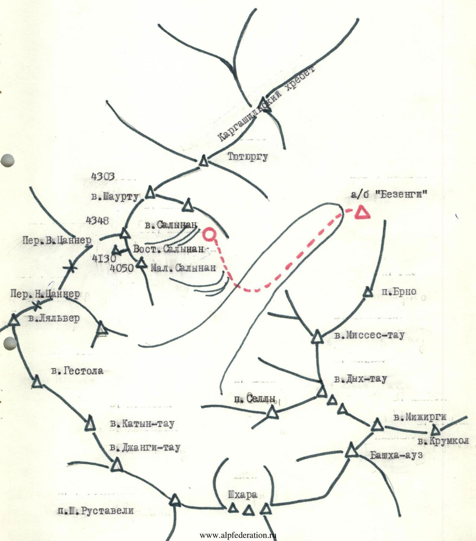
- Ascent area — Bezengi region, Kargashil ridge.
- Peak — Maly Salynan, height — 4050 m
- Ascent route — via the North couloir of the East ridge.
- Estimated difficulty category — 3B
- Height difference — 730 m, length of sections with 3–4 difficulty category — 120 m, average steepness — 43°
- Pitons driven (including ice screws) — for belay 49/0 Number of used chocks — 8 pcs.
- Number of climbing hours — 11
- Number of nights stayed — the route is one-day.
- Leader — Belousov E.B. — Candidate Master of Sports; participants:
- Fedorchuk N.I. — 2nd sports category.
- Markina I.B. — 2nd sports category.
- Popov Yu.P. — 2nd sports category.
- Butrim V.I. — 2nd sports category.
- Govorun V.I. — 2nd sports category.
- Team coach — Belousov E.B. — Candidate Master of Sports
- Date of departure on the route — August 3, 1986, return — August 3, 1986.
- The ascent was organized by the training department of the Bezengi alpine base and the KSP of the Bezengi region.
Area Map
Approach Description
From the Bezengi alpine base, the path goes along the right-bank (orographic) moraine of the Bezengi glacier to Misses-Kosh.
Next, you need to descend along the trail to the glacier and move up the glacier, gradually crossing it, in order to reach the third stream, counting from the bottom up from the stream flowing from the glacier circus, opposite Misses-Kosh. The third stream flows out of the Salynan glacier circus.
From the Bezengi glacier you need to:
- Climb to the left (orographic) moraine to the right of the stream.
- Move along the stream to the "ram's foreheads".
- Here you should cross the stream and move up the left (in the direction of travel) side of the stream.
- Above the first "ram's foreheads" you should cross again to the right (in the direction of travel) side of the stream and ascend first through the grass, and then through the talus towards the glacier tongue.
- The glacier tongue is bypassed on the right along the talus.
In the place where the glacier becomes less steep, there is a convenient camping area on the talus. The journey from the alpine base takes 5–6 hours.
Route Diagram in UIAA Symbols
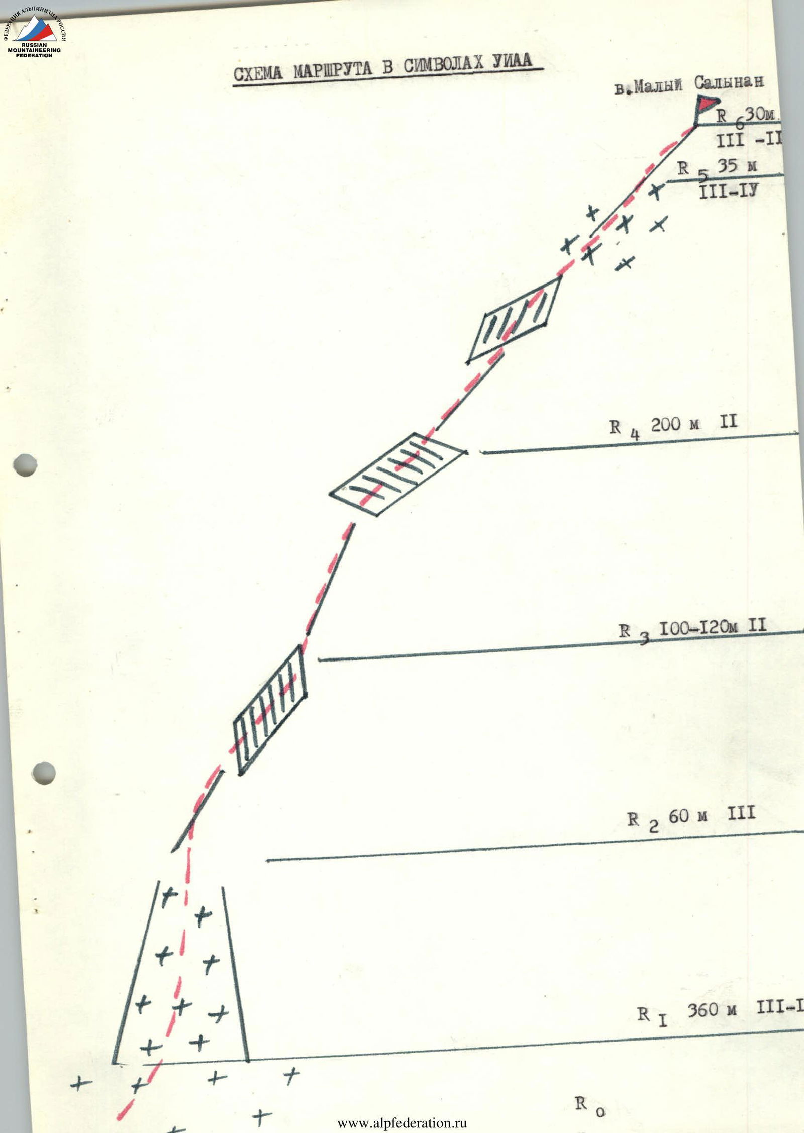
Route Description to Maly Salynan Peak
Via the North Couloir of the East Ridge.
From the initial bivouac, crossing the glacier diagonally and passing the second step of the Salynan glacier icefall in the left part (closed crevices, belay), reach the wide ice couloir of the East ridge, under the bergschrund. From the bivouac 1.0–1.5 hours.
Having overcome the bergschrund, ascend straight up the couloir to the ridge. The steepness of the ice couloir is 45–55°, the length is 360–380 m. Belay via ice screws. From the start of the route to the ridge 4 hours. On the ridge — a control cairn.
Along the ridge to the right, bypassing the first "gendarme" on the left (pitons belay) in the direction of Maly Salynan peak.
The next two "gendarmes" are overcome directly head-on.
The last pre-summit "gendarme" is bypassed on the left with an exit to the saddle between the "gendarme" and the pre-summit rise of the ridge.
Cross from the left side to the ridge and move straight up the ridge to the summit (pitons belay).
From the control cairn on the saddle to the summit 3 hours.
Descent along the East ridge to a wide talus couloir on the left (in the direction of travel) side of the ridge, with an exit to the glacier plateau, approximately along the route of 2B difficulty category. From the summit to the plateau 2–3 hours.