PASSPORT
of the ascent made in the Leningrad Alpine Championship 1976.
- ASCENT CLASS — technical.
- ASCENT AREA — Central Caucasus, Bezengi alpine camp, Mizhirgi gorge.
- ASCENT ROUTE — Mises-Tau peak (4320 m) via the right counterfort of the eastern wall. First ascent. (Approximately 5B category of difficulty.)
- ASCENT CHARACTERISTICS: route length 1730 m; height difference 1000 m; average steepness of the route – 53°; wall sections – 70°; length of difficult sections – 750 m.
- PITOONS DRIVEN: rock – 124; ice – 3.
- NUMBER OF DAYS ON THE ROUTE — 3 (not counting 1 day for preparation and 1 day for descent).
- NUMBER OF HOURS ON THE ROUTE — 30.
- NUMBER AND CHARACTERISTICS OF NIGHTS — 3 nights on snow, platforms were prepared.
- TEAM NAME — team of the Order of Lenin Leningrad Military District.
- TEAM MEMBERS: SHEVCHENKO Y.S. – MO USSR, captain and coach; PAKHOMOVA A.V. – MO USSR; CHEREPOV V.A. – CMS; PRIBYLOVSKY A.V. – 1st category.
- ASCENT DATE – July 24–28, 1976.
- TEAM'S FINAL POSITION:
ASCENT DESCRIPTION
The initial bivouac is conveniently located on a moraine ridge (platforms for two tents were made) within 15 minutes' walk from the counterfort. The approach from the alpine camp takes about 3–4 hours and goes sequentially through Mizhirgi glade, "football field", then along the glacier to a short moraine abutting a rock wall, under which, as known, they spend the night before heading to the north-eastern counterfort of Dykh-Tau. When passing this rock wall, it is advisable to hang a 40-meter rope. Further, the path goes up and slightly left along talus and "ram's foreheads" to a small moraine under the Mises-Tau wall. The group left the camp at 14:00.
JULY 24
At 8:00, the "duo" Shevchenko–Cherepov started processing the route. They took 5 ropes of 40 m each and a varied set of pitons. Ascent up the snow cone to the throat. Through a small rinklif. Along the "ram's foreheads" on the right (by the route) side of the throat, 15 m under the wall-shelter. 65–75 m up the smoothed, местами grassy, fairly difficult rocks, under the overhanging wall to the right of the water streaks (R0–R1). Traverse left (15–20 m) and further, avoiding overhangs, in such a way as to reach a green shelf under a wide wall blocking the ascent path. From the start of the rocks to this point is 180 m (R1–R1).
Ahead is a wall with an internal angle. Here, the last belay rope is secured. A total of 5 belay ropes are hung. At 13:00, the "duo" descends to the bivouac.
JULY 25
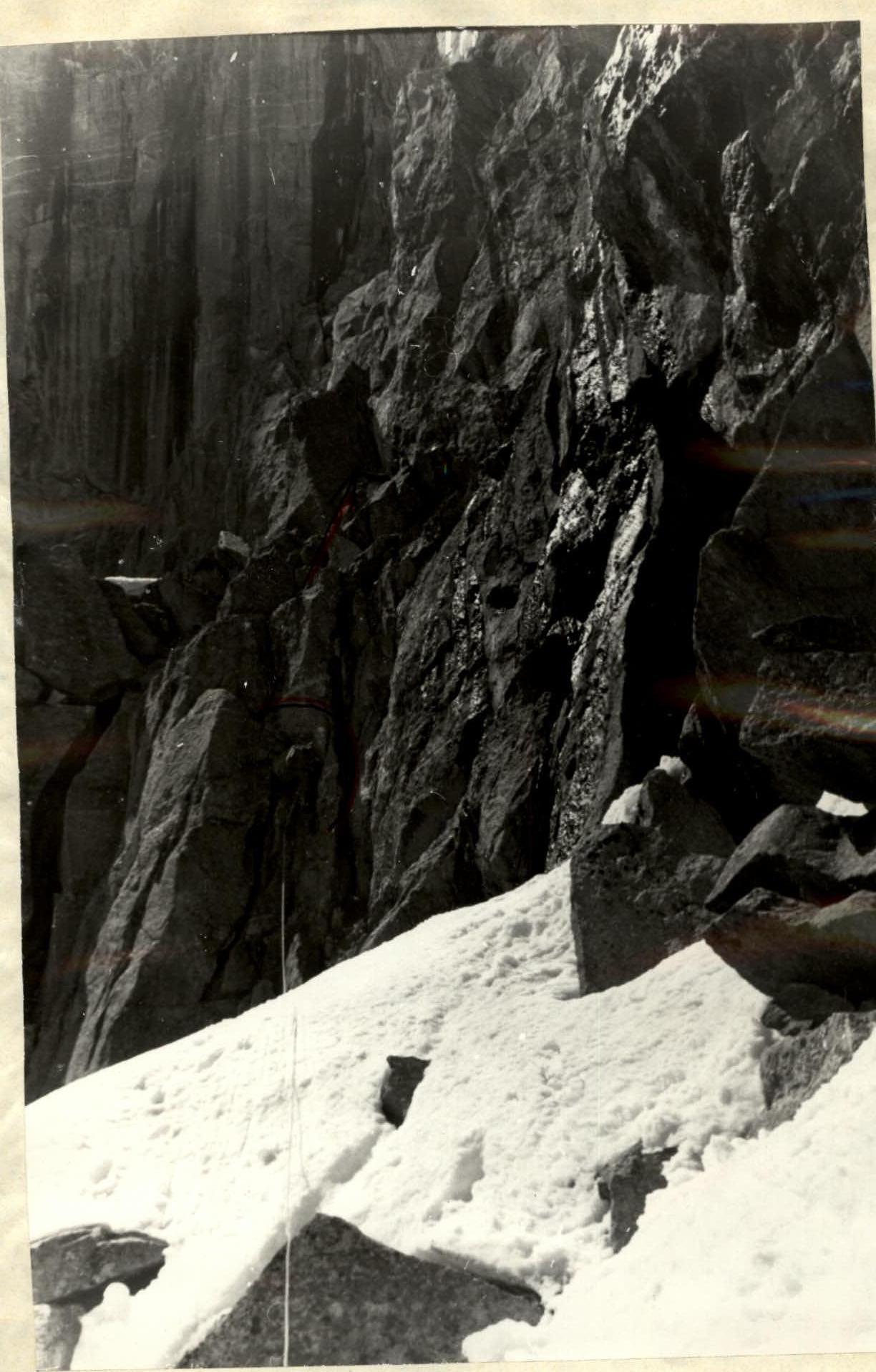
At 9:00, the group starts the ascent. Ropes: Shevchenko–Cherepov, Pakhomova–Pribylovsky. Having passed the belays (R0–R1), two ropes are thrown down and picked up by observers. We take 3 ropes with us. Ahead is a wall, with its right part cut by a vertical internal angle. For this part of the ascent, and especially further, it is convenient for the leader to wear galoshes. 50 m up the internal angle (difficulty is average, then high) under an overhang (R2–R3). Exit through the overhang into the angle (very difficult), formed by a vertical wall and a slab. The leader's backpack is pulled out. Ahead, a powerful cornice blocks the path, so along the slabs, sometimes on small ledges, we move right-up to a convenient shelf – 35–40 m (R3–R4).
Then 20 m up a wide internal angle-chimney with a 3–4-meter overhanging very difficult wall (pulling out the leader's backpack) (R4–R5). Exit to a shelf with snow under a belt of vertical rock-lbs with water streaks. Traverse left 20 m (R5–R6), then up 20 m along a difficult wall (R6–R7). The outer angle is bypassed left-up 25 m (R7–R8).
Further, it is necessary to move left, crossing a complex steep snow-ice couloir (R8–R9), as the path up directly to the ridge is blocked by absolutely smooth rocks. Exit to the "rooster's comb" counterfort gap on a snow saddle. Here, at a convenient spot, the group spent the night. There are many bivouac spots on the counterfort, especially "sitting" ones. On the same day, we process the section (R9–R10) of a complex wall. The weather is cold, with strong winds on the saddle.
JULY 26
Departure at 8:00. From the gap, the route goes along an even more complex part of the ridge. 35 m of very difficult climbing straight up smooth steep slabs-walls (R9–R10). Here, one can apparently traverse to the right about 30 m with some descent, and then ascend via internal angles. Exit to a rock platform (2 × 2 m) on the ridge. Traverse 5 m to the right along a good shelf to a 30-meter vertical (up to 70–80°) internal angle with sections of growing grass. Its smooth sides, particularly the overhanging right face in the middle and upper parts, are very difficult. 6–8 m after reaching the ridge, there is a very convenient ledge for belaying. A control cairn is set up here.
15–20 meters above the ridge, a powerful cornice with a 3-meter overhang blocks the path. It is bypassed by complex climbing as follows:
- Up about 3 m,
- Traverse right behind the wall (first without a backpack),
- And then up about 15 m (R11–R12).
Exit to a wide shelf going down to the right, along it about 20 m under a vertical internal angle-chimney with live rocks (R12–R13). 25 m of complex climbing up, then 45 m of less complex rocks (R13–R14). Further, there are 90–100 m of rocks of medium difficulty, interrupted by snow ledges (R14–R15). The route becomes less steep and turns left (from above over the "mirror"), approaching the powerful wall of the north-eastern counterfort.
At the same time, moving right is blocked by a steep and very dangerous, looking complex, couloir. We move up along the ridge over difficult smooth, almost grip-less rocks (R15–R16). After about 60 m, the path is blocked by a gendarme-lb, which can be bypassed on the right – 25 m (R16–R17), traversing the wall, then along a lateral steep ice couloir (80°), covered by snow overhangs, crossing a vertical snow ridge-knife dividing the couloir into two parts, and further up steep rocks to the "lb" (R17–R18). Technically and psychologically very complex section, one of the key places on the route. Backpacks were pulled out.
Then 60 m along the ridge, over rocks and snowfields under a new ascent. About 70–80 m of complex rocks (R18–R19), after which there is a series of simple ledges leading left-up, bypassing the wall of the north-eastern counterfort, 180–200 m (R19–R20). Further, 140 m of rocks of medium complexity, sometimes complex. This section (R20–R21) is characterized by the presence of live slabs, often quite large, and requires special attention when passing.
On a snowy shoulder, before exiting to a 100-meter snowy ascent leading to the ridge of the north-eastern counterfort, the group organized a bivouac. We believe that at this point our route converges with the route along the eastern wall of B. Garf and the path along the northern ridge of Mises/45.
JULY 27
We pass the 100-meter snowy ascent (R21–R22) leading to the counterfort ridge, representing essentially the right side of a wide snow-ice couloir descending to the Mizhirgi glacier. Snow blown from the south-western side accumulates here. This should be considered when moving after a warm night, as was the case for the first ascenders. The avalanche danger in this case increases, which was especially evident in 1976 – the year of "big snow".
The group "pierced" the slope vertically with large, well-trodden tracks. From here, there are another 5 ropes of snowy slope with gradually increasing steepness leading under the rock tower of Mises-Tau, onto the path along the northern ridge (R22–R23).
Under the tower, traverse right 20 m and then exit to rocks. Along the rocks, 40 m up with difficult climbing (R23–R24) and further along the ridge over broken rocks 40–60 m (R24–R25). The ridge leading to the summit is a chain of gendarmes with fairly deep gaps between them. From the north-western side, they are covered in ice and have great steepness, so movement along the right (by the route) side of the ridge is complex and dangerous.
We traverse left along steep ledges-slab along the ridge 70–80 m, overcoming a complex internal angle-chimney, for which ladders are used (R25–R26).
Under the very summit tower, up along the internal angle 60 m, climbing becomes more complex due to the presence of many live rocks (R26–R27). The internal angle gradually widens and leads to the pre-summit ridge. Then along broken rocks 40 m (R27–R28) and further along the snowy ridge 60–80 m (R28–R29) to the summit. The group reached the summit at 16:00 on July 27. A bivouac was organized in a snow depression behind the summit, above the couloir, down which the descent was to be made.
JULY 28
Departure at 6:00. Descent along the left couloir to "Russian bivouacs" and by 11:30, we were on the Bezengi glacier. Return to the alpine camp at 14:30.
Russian Alpine Federation Website↗
TABLE OF MAIN CHARACTERISTICS OF THE ASCENT ROUTE
Ascent route: Mises-Tau peak via the right counterfort of the Eastern wall / First ascent / Height difference of the route: 1000 m. Route length: 1750 m. Including the most complex sections: 750 m. Route steepness: average 53°, wall sections 70°.
| Date | Passed sections | Average steepness of the section | Section length (by length), m | By terrain character | Category of difficulty of the section | By method of overcoming and by belaying | Driven rock pitons | Driven ice pitons | Driven bolt pitons |
|---|---|---|---|---|---|---|---|---|---|
| I | 2 | 3 | 4 | 5 | 6 | 7 | 8 | 9 | 10 |
| Route preparation | |||||||||
| July 24 | |||||||||
| Departure at 8:00 | R0–R1 | 60° | 80 | "ram's foreheads", rock walls, ledges | 4–5 | Free climbing, pitons, belays | 8 | ||
| R1–R2 | 50–60° | 100 | Rock walls, internal angles, shelves | 4–5 | Free climbing, pitons, belays | 9 | |||
| 180 | 17 | ||||||||
| Return to bivouac at 13:00 | |||||||||
| July 25 | |||||||||
| Departure at 9:00 | R2–R3 | 70° | 50 | Passage of processed sections R0–R2, internal angle | 5 | Free climbing, pitons, belays | 5 | ||
| R3–R4 | 80° | 40 | Rock cornice, slabs | 5–6 | Pitons, ladders, belays | 7 | |||
| R4–R5 | 70–80° | 20 | Angle-chimney, overhang | 5–6 | Pitons, ladders, belays | 3 | |||
| R5–R6 | 10–15° | 20 | Inclined shelf with snow and outcrops | 4 | Free climbing via outcrops | ||||
| R6–R7 | 80° | 20 | Rock wall with ice | 5 | Free climbing, belays | 4 | |||
| R7–R8 | 60° | 25 | Outer angle, narrow shelf | 5–6 | Pitons, belays, ladders | 3 | |||
| R8–R9 | 60–70° | 20 | Ice couloir with exit to snow saddle | 5 | Free climbing, belays | 3 | 1 | ||
| 18:00 | 25 | 1 | |||||||
| Stop for the night, preparation of a platform on entire snow saddle. Wind, cold. | |||||||||
| For the day (9 working hours) 375 m were passed |
JULY 26
Departure at 8:00
| R9–R10 | 70–80° | 20 | walls, slabs | 5–6 | Free climbing, ladders, pitons, belays | 4 | | | |---|---|---|---|---|---|---|---|---|---| | R10–R11 | 80–80° | 30 | internal angle, overhanging walls | 5 | Free climbing, pitons, belays | 3 | | | | R11–R12 | 80–85° | 30 | Cornice 3 m, outer angle, sheer wall | 5–6 | Free climbing, pitons, ladders, belays | 3 | | | | R12–R13 | 80–90° | 25 | internal angle-chimney, live rocks | 5–6 | Pitons, ladders, belays | 5 | | | | R13–R14 | 60–70° | 45 | rock walls, narrow ledges | 5 | Free climbing, pitons, belays | 4 | | | | R14–R15 | 30–40° | 100 | Rocks of medium difficulty, with shelves and outcrops | 4 | Free climbing, outcrops, pitons | 3 | | | | R15–R16 | 80–85° | 60 | Walls, slabs, with few grips and cracks | 5–6 | Pitons, ladders, belays | 7 | | | | R16–R17 | 70–80° | 25 | Sheer walls, complex traverse | 5 | Free climbing, pitons, belays | 6 | | | | R17–R18 | 78–85° | 25 | rocks, ice couloir | 5–6 | Ladders, pitons, belays | 4 | 2 | | | R18–R19 | 60–70° | 80 | rock walls | 5 | Free climbing, pitons | 8 | | | | R19–R20 | 20–30° | 180 | rock ledges, broken | 4 | Free climbing, outcrops, alternating | 2 | | | | R20–R21 | 60–70° | 140 | broken rock shelves | 5 | | | | | | | | | 750 | | | | | 59 | 2 | |
Stop for the night on a snowy shoulder. Platform was prepared. Weather is overcast, windy. For the day (11 working hours) 760 m were passed.
JULY 27
Departure at 8:00
| R21–R22 | 60° | 100 | snowy slope | 4–5 | Pitons, ice axe, belays | 3 | | | |---|---|---|---|---|---|---|---|---|---| | R22–R23 | 30–40° | 200 | snowy ridge | 4 | Ice axe, alternating | | | | | R23–R24 | 70–80° | 40 | rock walls | 5 | Free climbing, pitons, belays | 6 | | | | R24–R25 | 40° | 40 | broken rocks | 4 | Free climbing, pitons, belays, alternating | 3 | | | | R25–R26 | 80° | 70 | rock slabs, internal angles, shelves | 5 | Pitons, belays, ladders | 3 | | | | R26–R27 | 70° | 40 | broken rocks, internal angle, live rocks | 4 | Free climbing, pitons, belays, alternating | 4 | | | | R27–R28 | 40° | 40 | snowy-rocky ridge | 4 | Pitons, ice axe, alternating | 2 | | | | R28–R29 | 20° | 60 | snowy-rocky ridge | 4 | Simultaneously | | | | | | | 590 | | | | | 23 | | |
Reached the summit at 16:00. Further path along the north-western ridge. Stop for the night in a snow depression. For the day (10 working hours) 590 m were passed.
Team Captain: Yu. Shevchenko
Section 3–4 (final part). Exit to a shelf.
Section 12–13 / angle-chimney /
