80
Description of the Ascent Route to Koshtan-Tau Peak (5144 m) via the Central Counterfort of the North Face (First Ascent)
The ascent to Koshtan-Tau (5144 m) from the north via the central counterfort was accomplished between July 11 and 16, 1969, by a group from the LОС DSO TRUD, consisting of:
- Nosov A.P., CMS - leader
- Dreitser V.D., CMS - participant
- Shymelis V.P., CMS - participant
- Kosobokov L.I., 1st sports category - participant
- Kuritsyn I.F., 1st sports category - participant
Koshtan-Tau (5144 m) is located in the northern spur of the central part of the Main Caucasian Range and is one of the highest peaks in the Caucasus. From the north, several routes have been ascended and classified to the summit: 4B-5B category of difficulty.
The path chosen by the group via the central counterfort of Koshtan-Tau's north face had long attracted the attention of Leningrad climbers, but in 1964, it was ascended by Czechoslovakian climbers, although they left no information about their ascent.
As seen in Photo 1, the route is a rocky, wide counterfort, girded below by a steep ice slope-wall and above by an overhanging ice barrier. Above the barrier are wide snow slopes leading to the summit.
After carefully studying photographs and observing the route, the following ascent plan was adopted (see Photos 1, 2, 3):
a) Traverse the steep ice slope and lower part of the wall to a sharp snowy ridge under the overhanging black wall.
b) Ascend the upper part of the wall, exit under the ice barrier, and then follow one of two options:
- directly through the barrier, as the Czech climbers did;
- or bypass it to the right or left, depending on the condition of the ice barrier.
c) Descend from the summit via the north ridge, category 4A. The tactical plan for the ascent included passing the wall with two bivouacs. Upon observation, potential safe bivouac sites were identified at the following points:
- base camp on the 4th step of the Kundryum-Mizhergi glacier;
- 1st bivouac on the route under the overhanging black rock on the upper part of the wall on a sharp snow-ice ridge;
- 2nd bivouac on the route on or beyond the summit on the ridge.
Brief Description of the Ascent
Day I. The group departed from the Bezengi alpine camp on July 11, 1969, at 18:00 and stopped for the night on the 1st step of the Kundryum-Mizhergi glacier.
Day II. Departure at 6:00. The group ascended to the 4th step of the glacier by 10:00 and observed the route.
Day III. Very early departure at 4:00. Initially, the path follows a steep snowy slope (avalanche prone) to the bergschrund. Above the bergschrund, a steep ice slope begins. Movement in crampons on front points with careful piton protection. The slope's steepness is 55°–60°, pure ice. The lower part of the rocky counterfort is quite steep. The first rocks overhang, so this section is bypassed by complex climbing on a rocky-icy ledge to the right, then several ropes up steep rocks. Further, the counterfort becomes less steep (300 m). This part of the path alternates between heavily destroyed rocky walls 2–3 m high and ice-filled rocky gullies. The section is very dangerous due to numerous loose rocks. Icy rocks complicate climbing. Then the counterfort narrows into a rocky couloir (60 m) with a steepness of 70°, leading to a narrow icy ridge, the intended bivouac site.
The group worked for 16 hours and 30 minutes on this day.
Day IV - bad weather, snow, strong wind, zero visibility.
Day V - bad weather, snow, gusty wind, zero visibility.
Day VI - departure at 6:00. Strong wind, but sun breaks through the clouds. Complex climbing resumes. Again, steep rocks in ice. The lead climber continuously clears footholds and cracks of ice with a hammer.
From the bivouac:
- 150 m up the wall to the ice barrier.
The ice barrier overhangs the counterfort with a 100-meter wall. The severe fragmentation of the ice poses a threat of collapse at any time. Depending on the barrier's condition, it can be passed:
- directly head-on;
- or bypassed to the left;
- or bypassed to the right.
In this case, passing the barrier head-on is impassable.
The group decided to bypass the ice wall to the right. The bypass route traverses a rocky-icy slope (dangerous!), then along the wall on ice and up rocks to a snowy ridge above the wall. The bypass is 300 m long.
The upper part - exiting onto the ridge and then along the ridge to the summit - does not present particular technical difficulty, but movement is hindered by:
- lack of oxygen (altitude 5000 m);
- cold;
- wind.
The group reached the summit at 15:00 and began descending via the north ridge. They set up a bivouac near the 2nd gendarme. On this day, the group worked for 13 hours.
Day VII - descent to the Bezengi alpine camp. The descent from the bivouac under the 2nd gendarme to the camp took 11 hours.
Technical details of the route are provided in the table on page.
Main Equipment of the Group
- 4-person tent - 1 piece
- Main rope 40 m - 2 pieces
- Auxiliary rope - 1 piece
- Carabiners - 20 pieces
- Rock pitons, various - 30 pieces
- Ice pitons, equal - 7 pieces
- 3-step ladders - 4 pieces
- Rock hammers - 2 pieces
- Ice axes - 2 pieces
- Ice axes - 3 pieces
- Ice screws - 2 pieces
- Drill - 1 piece
- Expansion pitons - 10 pieces
- Rope ascenders - 5 pieces
- Protective helmets - 5 pieces
- "Focus" brand stove - 1 piece
- Fuel in sufficient quantity and assortment - 12 kg
- Gasoline for the stove - 3 liters
Generalizations, Recommendations, and Assessment of Route Difficulty
- The ascent route to Koshtan-Tau (5144 m) via the central counterfort of the north face is combined, of considerable length (1942 m). The main technical difficulty lies in overcoming the 600-meter wall located at an altitude of 4200–4800 m.
- When traversed by a group of 5, a total of 26 climbing hours were spent, 70 rock pitons were driven, 40 ice pitons, and ladders were used 6 times.
- The route's significant steepness in its middle part (70°–75°) and its extreme destructiveness pose a danger of rockfall, necessitating the use of helmets.
- The northern aspect and severe glaciation of the rocks complicate the route, forcing climbers to use crampons on rocks and requiring the lead climber to climb without gloves. Additionally, the lead climber must continuously clear footholds and cracks of ice.
- The lack of bivouac sites in the lower and middle parts of the route forces the group to work extensively and intensively on the first day (15–18 hours) to reach the ice-snow ridge. There are no convenient platforms on the wall.
- The path begins on snow, then ice. The first working day is very long, so it's recommended to depart from the bivouac very early, at 3:00–3:30.
- The massive ice barrier, over 100 m high, in the upper part of the counterfort can collapse at any moment. The presence of this ice wall overhead significantly increases mental strain and prompts the group to hasten their passage.
- The only place on the wall where a tent can be pitched is on the snow-ice ridge under the overhanging black wall.
- The route is recommended for a group of no more than 4 people.
- When overcoming the ice barrier (either directly or bypassing), besides technical proficiency, a high level of mental and volitional preparation is required, i.e., group members should have substantial experience in ascending peaks of category 5 difficulty.
- It is recommended to ascend the route in good weather, as during snowfall, even light, snow falling on the northern slopes of the summit dome flows down the couloirs to the right and left, partially covering various sections of the route.
- The snow-ice ridge is considered the only safe bivouac site. However, in the rare event of severe ice falls from the ice barrier, the entire route can be overwhelmed by an avalanche of falling ice and snow.
- The route is recommended for highly qualified, cohesive groups proficient in rock and ice techniques and having undergone sufficient acclimatization.
- Members of the assault group (Nosov, Dreitser, Shymelis, Kuritsyn, Kosobokov) had previously accomplished first ascents of several category 5B and 6 routes in the Caucasus, Tian Shan, and Pamir (East Mizhergi peak via the north face, Usechyonka peak via the NW wall, traverse of the Alamudinskaya wall, Tajikistan peak via the NE wall, Babel peak via the South shoulder), and had also completed routes considered benchmarks for category 5 difficulty (Koshtan-Tau via the north face, A. Simonik's path via the NE wall, Kalyshevsky's path, Khar peak via the north edge, and several other classic category 5 routes).
Based on a comparison of technical difficulty, psychological, and physical strain, the route to Koshtan-Tau's summit fully meets (and even exceeds) the requirements for category 5B routes.
The group proposes that the Classification Committee consider the presented route as corresponding to category 5B difficulty.
Despite the route having been ascended by Czechoslovakian climbers in 1964, the group requests the Classification Committee to recognize their ascent as a first ascent due to:
- the absence of any data on the previous ascent;
- the route's absence from the All-Union classification;
- significant changes in the ice barrier's relief (it became more dangerous and completely impassable head-on).
Ascent materials have been submitted to the Classification Committee of the USSR Alpine Federation.
Group Leader
(Nosov)
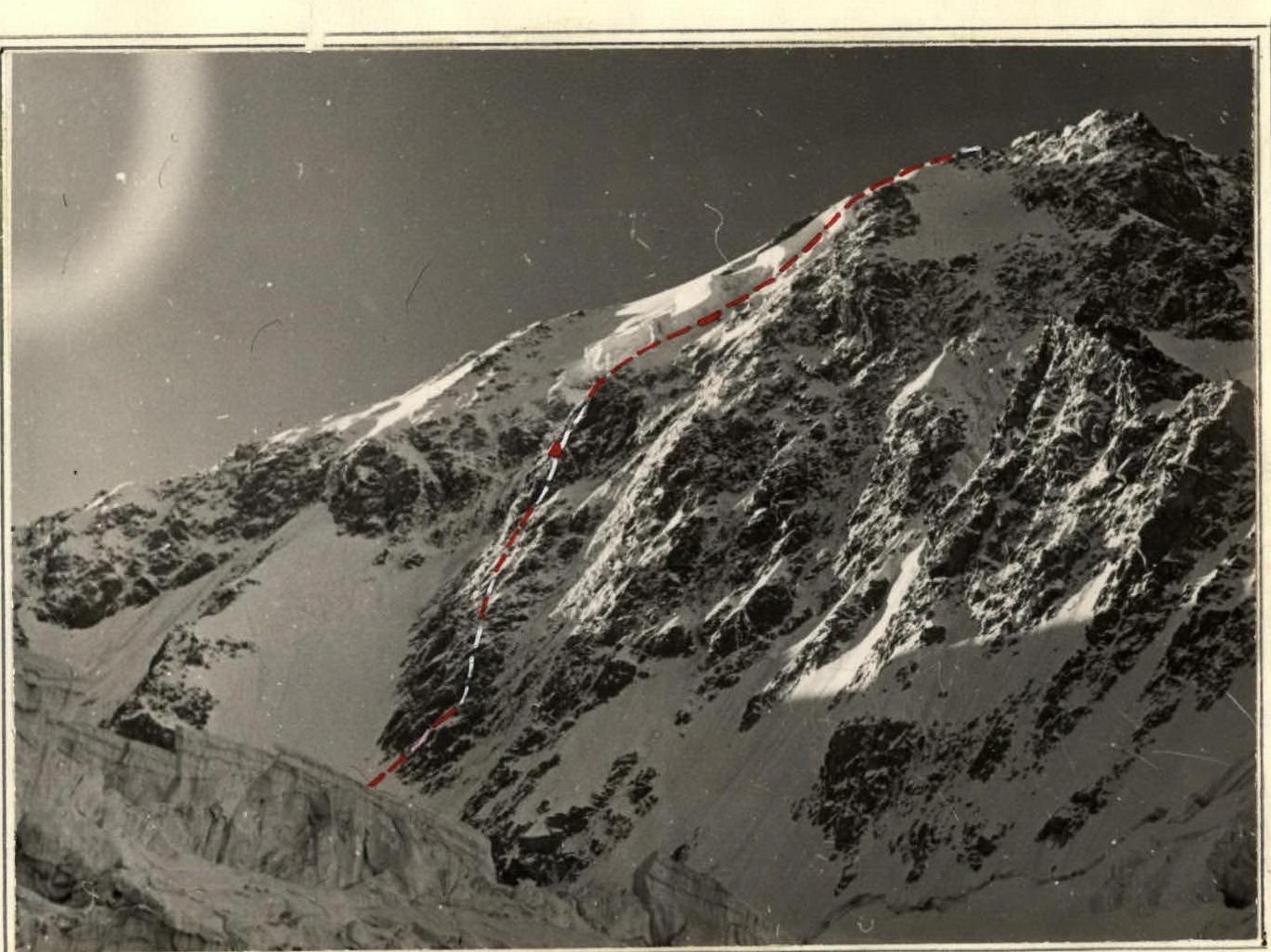
Photo 2.

Photo 3.
Table
Main Characteristics of the Ascent Route
Ascent route - North face of Koshtan-Tau via the central counterfort, category 5B (first ascent). Height difference on the route - 5144 m - 4000 m. Average steepness of the route - 55°. Length of the path to the summit - 1942 m.
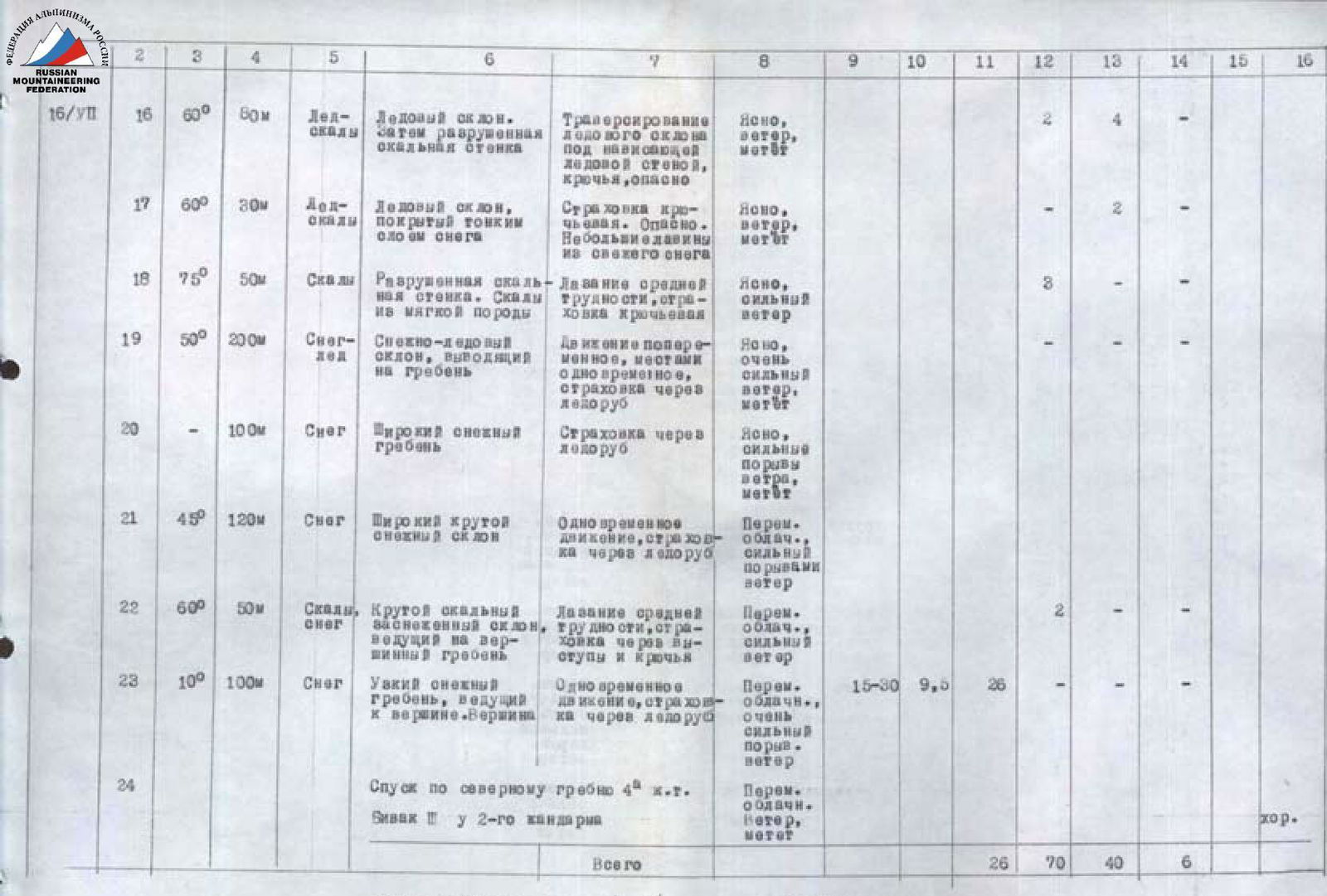
| № | Day / Section | Material | Steepness | Length (m) | Characteristics of sections and conditions of passage | Technical difficulty | Method of overcoming and protection | Weather conditions | Time of stop | Time of passage | Climbing hours | Rock pitons | Ice pitons | Ladders | Bivouac conditions | Daily ration | |---|---|---|---|---|---|---|---|---|---|---|---|---|---|---|---| | 13/VII | 1 | Snow | 35° | 200 | Steep snowy slope formed by avalanche deposits | | Movement in 3 steps, protection via ice axe, avalanche danger | Clear | | | | | | | | | | | 2 | Ice | 55°–60° | 300 | Steep ice slope with large areas of pure ice | | Crampons on front points, steps, pitons | Clear | | | | - | 22 | - | | | | | 3 | Rocks, Ice | 70° | 300 | Gently sloping rocky ledge, iced along the overhanging wall | | Crampons on rocks, pitons | Clear | | | | 8 | 4 | - | | | | | 4 | Rocks | 100° | 2 | Overhanging rocky wall | | Climbing using a ladder | Clear | | | | 2 | - | 1 | | | | | 5 | Rocks | 90° | 10 | Internal corner abutting the overhanging wall | | Complex climbing, pitons, ladders | Clear | | | | 3 | - | - | | | | | 6 | Rocks | 80°–90° | 80 | Steep, destroyed rocky walls | | Complex climbing. Rockfall danger | Clear | | | | 9 | - | 2 | | | | | 7 | Rocks, Ice | 75° | 120 | Rocky walls and icy ledges covered with a thin layer of snow | | Protection via pitons, ice steps, clearing rocks of ice | Clear | | | | 9 | 2 | 1 | | | | | 8 | Rocks, Ice | 75° | 50 | Diagonal ledge 10 m along the overhanging wall and then an iced rocky gully 40 m | | Very complex climbing on the ledge, piton protection | Clear | | | | 7 | 1 | 1 | | | | | 9 | Rocks | 65° | 40 | Destroyed rocky ridge | | Climbing of medium difficulty, protection via protrusions and pitons | Clear | | | | 3 | - | - | | | | | 10 | Snow | 50° | 40 | Snowy ledge - slope with rock outcrops | | Protection via pitons | Clear | | | | 2 | 1 | - | | | | | 11 | Rocks | 85° | 30 | Destroyed rocky gray wall leading to the left edge of the rocky couloir | | Piton protection, rockfall danger | Clear | | | | 4 | - | - | | | | | 12 | Rocks | 75° | 50 | Steep, narrow rocky couloir leading to a sharp icy ridge | | Complex climbing, pitons | Clear | | | | 5 | - | - | | | | 14/VII | Bivouac II | Ice | 80 | | | | Dark, Wind, Snowfall | 20:30 | 16:5 | 16:5 | | | | Night in a tent on a narrow icy ridge | | | 15/VII | Bivouac II | | | | | | | Wind, Snowfall | | | | | | | | | | 16/VII | 16 | Ice-Rocks | 60° | 80 | Iced rocky wall | | Complex climbing. Cold. Footholds and cracks under ice. Pitons | Clear, strong wind, drifting snow | | | | 6 | 1 | 1 | | | | | 17 | Ice-Rocks | 60° | 30 | Icy slope. Then destroyed rocky wall | | Traversing the icy slope under the overhanging ice wall, pitons, danger | Clear, wind, drifting snow | | | | - | 2 | - | | | | | 18 | Ice-Rocks | 75° | 50 | Icy slope covered with a thin layer of snow | | Piton protection. Dangerous. Small avalanches of fresh snow | Clear, wind | | | | 3 | - | - | | | | | 19 | Snow-Ice | 50° | 200 | Snow-ice slope leading to the ridge | | Alternating movement, partially simultaneous, protection via ice axe | Clear, very strong wind, drifting snow | | | | - | - | - | | | | | 20 | Snow | | 100 | Wide snowy ridge | | Protection via ice axe | Clear, strong gusts of wind, drifting snow | | | | - | - | - | | | | | 21 | Snow | 45° | 120 | Wide steep snowy slope | | Simultaneous movement, protection via ice axe | Variable cloudiness, strong wind | | | | | | | | | | | 22 | Rocks, Snow | 60° | 50 | Steep rocky snowy slope leading to the summit ridge | | Climbing of medium difficulty, protection via protrusions and pitons | Variable cloudiness, strong wind | | | | 2 | - | - | | | | | 23 | Snow | 10° | 100 | Narrow snowy ridge leading to the summit. Summit | | Simultaneous movement, protection via ice axe | Variable cloudiness, very strong gusty wind | 15:30 | 9:5 | 26 | | | | | | | | 24 | | | Descent via the north ridge, category 4A | | | Variable cloudiness, wind, drifting snow | | | | | | | | | | | Bivouac II near 2nd gendarme | | | | | | | | | | | | | | | | Total | | | | | | | | | | 26 | 70 | 40 | 6 | | |
Group Leader
(Nosov)