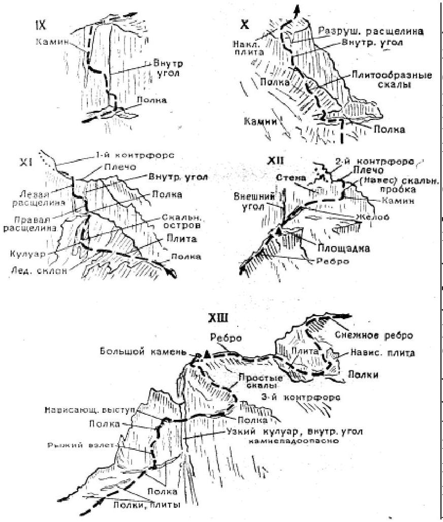
- Koshtantau via the Southwest Ridge — Cat. 5B (I. Galustov, A. Korchagin; K. Sizov, I. Smirnov, N. Shalaev, and V. Yakushkin — July 27, 1955; Fig. 13).
From the fork of the Dykhsu and Karasu gorges, ascend via a poorly-defined trail on the left bank of the Dykhsu River to the Green Glade below the Dykhsu Glacier. From the fork — 3.5–4 hr.
Further:
- From the glade, ascend via the left-bank moraine of the Dykhsu Glacier.
- After 500–600 m, cross onto the glacier.
- Via the central moraine of the Dykhsu Glacier, reach the confluence with the Aylama Glacier.
From there, cross
to its right side and ascend via it to the first right tributary valley, leading to the Krumkol valley. Descend to the Krumkol valley from the Dykhsu Glacier via the right-bank moraines of the Dykhsu and Krumkol gorges. Further, ascend via the right side of the Krumkol River up the valley. A canyon with an 8–10 m waterfall is bypassed on the right via “sheep's foreheads,” 5–15 m from the river. Further, ascend to sandy areas below the southern slopes of Tyutyuntau peak, 40–50 m above powerful and strong narzan springs discovered in 1962 by a group from the MGS DSO “Trud” led by the author. From the glade below the Dykhsu Glacier tongue — 6–7 hr.
From the narzan springs, ascend via the right moraine onto the Krumkol Glacier and via it reach the center of the icefall, leading to the Krumkol Sinkhole. Ascend via the center or left side of the icefall onto the upper snow plateau below the southern walls of the Koshtantau massif. In the center of the plateau — a bivouac. From the narzan springs — 4–5 hr. The path from the “Bezengi” alpine camp to the bivouac on the plateau is described in route 42.
From the plateau, via a gentle snow slope and through a bergschrund — exit onto the severely damaged simple rocks at the base of the Southwest (left) Ridge of Koshtantau's southern wall. Ascend 80–100 m via the rocks up and to the right, onto the right edge of the southern wall's ridge (rockfall!). From the edge, ascend 300–350 m via the smooth rocks of the ridge (rockfall!). From the right rock promontory, ascend 70–80 m via the left snowy-ice gully onto a rock “island.” Via the damaged, heavily snow-covered, moderately difficult rocks alternating with snow slopes (pitons) of the “island,” ascend 150–180 m below the rock belt of the southern wall, which is traversed via a narrow 60-meter rock-snow gully. Further, ascend leftwards via heavily snow-covered rocks alternating with 10–20-meter snow slopes and 2–5-meter wall sections — exit into the notch on the Southwest Ridge. In the notch — a bivouac.
From the notch, bypass the rock wall on the right and via snow slopes, ledges, and small wall sections, ascend up and to the right, exit onto a ledge on the Southeast Ridge. From the ledge, via a 3-meter wall section, then via moderately difficult rocks, ascend 50–60 m; the rust-colored wall is bypassed on the right and via simple, damaged, heavily snow-covered rocks, exit onto the Southwest Plateau, 100–120 m from Koshtantau's summit. On the plateau — a bivouac. From the bivouac on the Southwest Ridge — 10–11 hr.
From the bivouac, via a bergschrund and a snow slope, to the right of rock “islands,” ascend to Koshtantau's summit.
Descent:
- onto the Tyutyun Glacier
- via the Northeast Ridge (see in descriptions 46 or 35)
Recommendations for climbers
- Number of participants — 4–5 people.
- Initial bivouac — the Upper Cirque plateau of the right tributary of the Krumkol Glacier (rockfall from the peak's slopes!). Departure time — 3–4 am.
- Equipment: main rope — 2×40 m; expendable cordelette — 8 m; cordelette for descent — 40 m; rock pitons — 10–12; ice pitons — 5–6; rock hammers — 2; carabiners — 12–14; crampons — 4 pairs; tent — 1.
- Bivouac locations — on a ledge below the rock ascent, on a ledge on the Southeast Ridge, on the Southwest Plateau of the summit, and on the descent routes.