St. Petersburg Alpinism Championship, High-Altitude Technical Class
Report
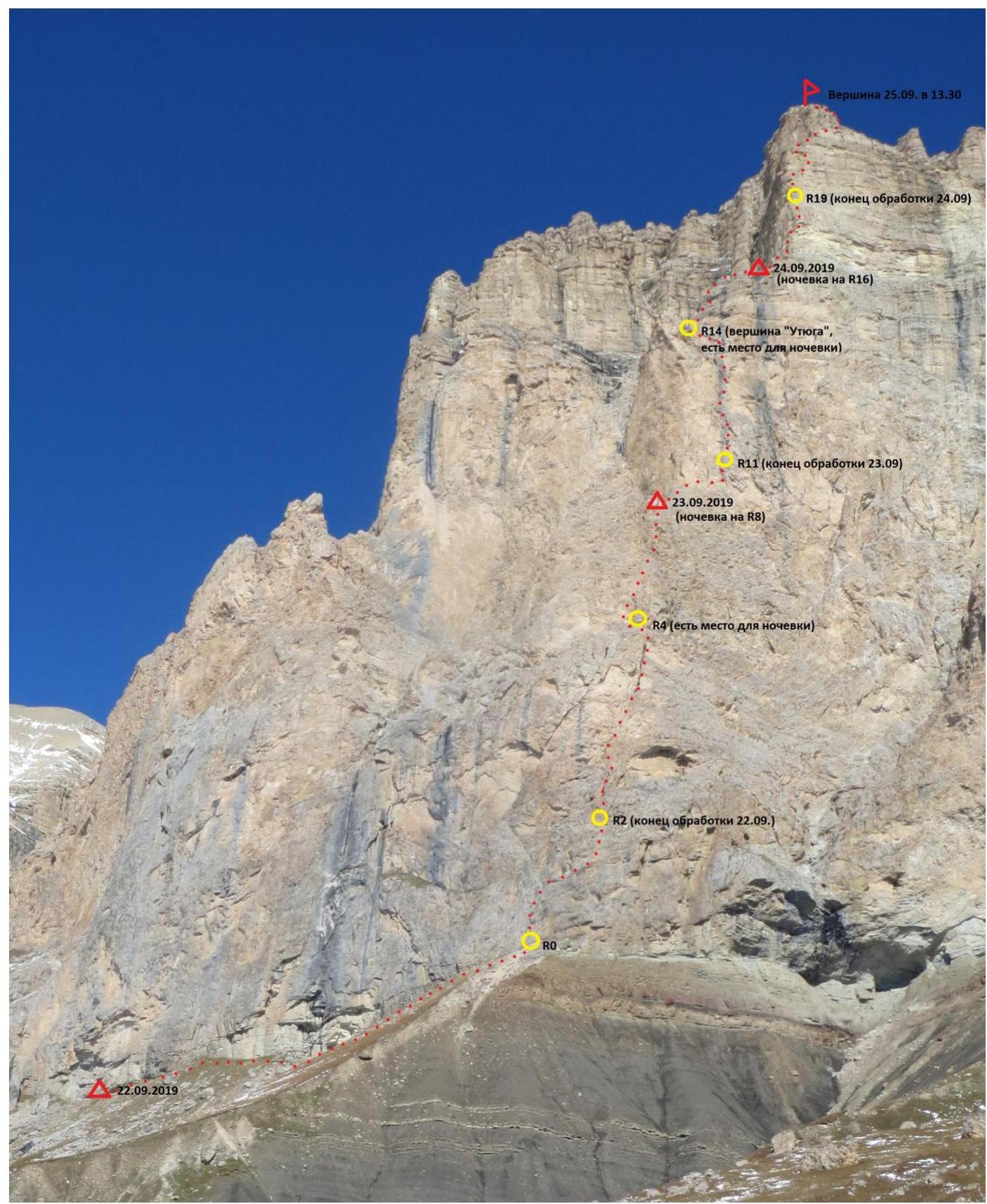
Ascent to the summit of Kara-Kaya (3646 m) via the central counterfort of the southwest wall, 6A category of difficulty, (E. Poltavets, 2010)
Team coach: Timoshenko T.I.
Participants:
- Kananykhin I.V.
- Solovey A.I.
I. Ascent Passport
1. General Information
| 1.1 | Leader's full name, sports rank | Kananykhin Igor Vladimirovich, CMS |
|---|---|---|
| 1.2 | Participants' full names, sports ranks | Solovey Alexey Igorevich, 1st sports rank |
| 1.3 | Coach's full name | Timoshenko Tatiana Ivanovna |
| 1.4 | Organization | St. Petersburg Alpinism Federation |
2. Ascent Object Characteristics
| 2.1 | Region | Central Caucasus |
|---|---|---|
| 2.2 | Gorge | Bezengi Gorge |
| 2.3 | Section number according to the classification table | 2.5.226 |
| 2.4 | Summit name and height | Kara-Kaya Central (3646 m) |
| 2.5 | Summit geographical coordinates (latitude/longitude), GPS coordinates | - |
3. Route Characteristics
| 3.1 | Route name | Via the Central Counterfort of the Southwest Wall (E. Poltavets, 2010) |
|---|---|---|
| 3.2 | Category of difficulty | 6A |
| 3.3 | Route familiarity | The route is rarely visited, traces of previous groups are not often seen |
| 3.4 | Route terrain | Rock |
| 3.5 | Route elevation gain (altimeter or GPS data) | 712 m |
| 3.6 | Route length | 1151 m |
| 3.7 | Technical elements of the route (total length of sections with different category of difficulty and terrain type) | V category rocks = 245 m, VI category rocks = 491 m |
| 3.8 | Average route slope (°) | Entire route = about 68° |
| 3.9 | Average slope of the main route section (°) | First bastion = about 76°, Second bastion = about 81°, Third bastion = about 87° |
| 3.10 | Descent from the summit | Rappelling down from the control cairn 100 m west of the saddle between Kara-Kaya Central and Kara-Kaya Western |
| 3.11 | Additional route characteristics | Logistics are convenient, good safe overnight stays are available near the wall. The route is "crumbly," especially the 2nd and 3rd bastions. No water in summer |
4. Team Tactical Actions
| 4.1 | Time in motion (team's walking hours, in hours and days) | 27 hours, 3 days (including movement on processed sections, descents from processing, and meals) |
|---|---|---|
| 4.2 | Route processing time | 2 hours, 1 day (including descent) |
| 4.3 | Route processing | 16:15–18:15, September 22, 2019 |
| 4.4 | Route entry | 07:15, September 23, 2019 |
| 4.5 | Summit arrival | 13:30, September 25, 2019 |
| 4.6 | Finished descending from the route | 17:45, September 25, 2019 |
5. Team Technical Actions
| 5.1 | Hooks left on the route | Not left |
|---|---|---|
| 5.2 | Hooks used on the route: | |
| — stationary pitons | 7 (all left by the first ascensionists) | |
| — removable pitons | Not used | |
| — for aid climbing | 1 total aid climbing | |
| 5.3 | Protection points used: | |
| — rock hooks | About 120 | |
| — chocks | About 15 | |
| — cams | About 135 |
6. Weather Conditions
| Temperature, °C | September 22–23: 10…15°C | |
|---|---|---|
| September 24: 0…10°C | ||
| September 25: –5…5°C | ||
| Wind speed, m/s | September 22–23: calm | |
| September 24: moderate, strong by evening | ||
| September 25: very strong, gusty | ||
| Precipitation | September 22–24: none | |
| September 25: short-term snow showers | ||
| Visibility, m | Good |
7. Report Responsible
- Kananykhin I.V., i.v.kananykhin@gmail.com
II. Ascent Area Description
1. Schematic Description of the Area
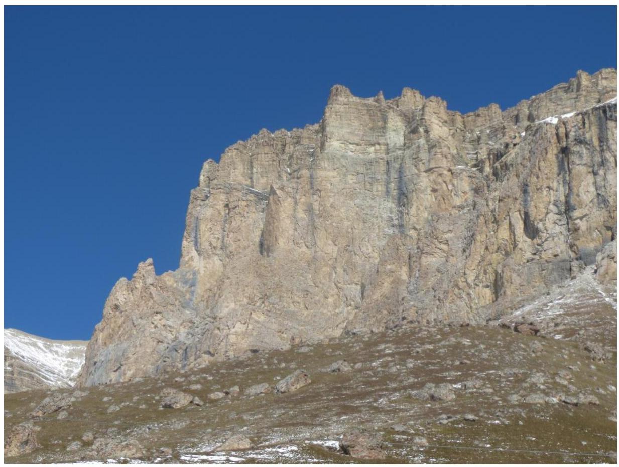
The Kara-Kaya summit is located in the Rocky Range of the Caucasus. The Rocky Range is parallel to the Main Caucasus Range and is divided into several massifs by deep canyons. Kara-Kaya is the highest point of the Rocky Range.
2. Approach to the Route Description
The approach to the Southwest wall is technically simple and takes about 2 hours.
III. Route Description
1. Route Profile
The profile of the first bastion from the west.

2. Technical Photograph of the Route
3. Route Diagram in UIAA Symbols
Kara-Kaya 3646 m via the Central Counterfort of the Southwest Wall, 6A (E. Poltavets, 2010)
4. Team Tactical Actions
September 22, 2019
The team arrived in Mineralnye Vody by train No. 49 from St. Petersburg at 07:11.
September 23, 2019
07:15. The team began the ascent via the processed section.
September 24, 2019
08:15. The team continued the ascent.
September 25, 2019
08:00. The team began the ascent via the processed section. 13:30. The team reached the summit of Kara-Kaya 3646 m. 17:45. The team finished descending from the route.
5. Descent from the Summit
From the summit, move along the edge of the wall towards Kara-Kaya Western to a characteristic saddle. Pass 100 m further from the saddle towards the Western summit to a cairn.
6. Recommendations for the Route and Safety Assessment
- In late September, the sun rises at 06:00, sets at 18:00.
- Radio communication with the Bezengi alpine camp is possible on all sections of the route.
- Mobile phone coverage (Megafon) is available on all sections of the route.
- The weather in September is unstable.
- Water is not available on the route during the dry season.
- The route is relatively safe in terms of rockfall, but the terrain is "crumbly" and "loose."
- The route is well-equipped with stationary pitons.
- The route allows for free climbing on all sections with a leader's free climbing level of 6c+ (Fr).
- Comfortable and safe overnight stays are possible on the route.
- For teams of two, it is recommended to use a haul bag instead of a backpack.
- The route is challenging but enjoyable.
7. Equipment List
7.1. Personal Equipment
| Item | Quantity | Notes |
|---|---|---|
| Harness | 1 per person | |
| Helmet | 1 per person | |
| Prusik cord | 1 per person | |
| Descender | 1 per person | |
| Self-belay device | 1 per person | |
| Carabiner | 4 per person | |
| Knife | 1 per person | |
| Sleeping bag | 1 per person | |
| Sleeping mat | 1 per person | |
| Headlamp | 1 per person | |
| Jumar | 1 per person | |
| Climbing shoes | 1 pair per person |
7.2. Group Equipment
| Item | Quantity | Notes |
|---|---|---|
| Dynamic rope | 1 | 50 m |
| Static rope | 1 | 60 m |
| Slings | 14 | 60 cm |
| Slings | 4 | 120 cm |
| Carabiners | 30 | |
| Carabiner | 5 | |
| Chocks | 1 set | |
| Hexentrics | 2 | |
| Cams | 1 set | |
| Pitons | 3 | |
| Hammers | 2 | |
| Extractor | 1 | |
| Fifi hook | 1 pair | |
| Haul bag | 1 | 70 l |
7.3. Bivouac Equipment
| Item | Quantity | Notes |
|---|---|---|
| Tent | 1 | 2-person |
| Jetboil | 1 | |
| Gas cylinder | 2 | 250 g |
| Thermos | 1 | 1 l |
| Food | for 2 people for 6 meals | |
| Water | 12 l |
7.4. Miscellaneous Equipment
| Item | Quantity | Notes |
|---|---|---|
| First aid kit | 1 | |
| Radio | 1 | |
| Mobile phone | 2 | |
| Route description printout | 1 | |
| Camera | 1 | |
| Passport | per person | |
| Health insurance policy | per person | |
| Emergency contact information | per person |
7.5. Comments on Equipment Selection
The team selected equipment carefully due to the need to carry water. The equipment was sufficient for the climb.
IV. Photo Illustration of the Report