Alpinism and Rock Climbing Federation of Kharkiv Region
Report
On the ascent of the Kharkiv region team to the summit of Kara-Kaya Western.
Via the Central buttress of the Southwest wall. Presumably 5B category of difficulty. First ascent.
Zakalodnii A. V. — team leader Poltavets E. I. Kotlyar R. S. Eremeev A. A. Timko E. N.
Ascent Passport
- Central Caucasus, Bezengi gorge, section 2.5 of the route classifier for mountain peaks.
- Kara-Kaya Western. Via the central buttress of the Southwest wall.
- Proposed category of difficulty: 5B. First ascent.
- Rock climbing route.
- Height difference: 490 m (by altimeter) Route length: 840 m. Length of sections with 5th category of difficulty: 270 m. Length of sections with 6th category of difficulty: 75 m. Average steepness of the wall section: 71°.
- Number of pitons used on the route: Bolt pitons — 0 Removable bolt pitons were not used. Total number of artificial protection points (AP) — 31.
- Team's total climbing hours: 28 hours, over 3 days.
- Descent from the summit to the west, then via the descent couloir (not classified) to Dumala pass, 2515 m.
- Team leader — Zakalodnii Alexander Vladimirovich. Master of Sports.
Coach — Samsonova L. N.
Team members:
- Poltavets Evgenii Ivanovich, Master of Sports.
- Kotlyar Roman Sergeevich, 1st sports category. Coach — Sukhareva L. N.
- Eremeev Anatolii Aleksandrovich, 1st sports category. Coach — Sukhareva L. N.
- Timko Evgenii Nikolaevich, 1st sports category. Coach — Sukhareva L. N.
- Departure to the route: 6:30, September 12, 2011. Reaching the summit: 18:30, September 14, 2011. Return to base camp: 11:20, September 15, 2011.
- Alpinism and Rock Climbing Federation of Kharkiv Region.
- Responsible for the report — Zakalodnii A. V. Email: zakal87@ukr.net
Description of the Climbing Area
The Kara-Kaya Western peak is located in the Rocky Range of the Caucasus. The Rocky Range is stretched parallel to the Main Caucasian Range and is divided into several massifs by deep canyons. Kara-Kaya peak is the highest point of the Rocky Range. The massif is composed of:
- Jurassic limestones,
- marls,
- dolomites. Only at the foot of the southern slopes are softer shales and sandstones exposed.
In this area, the Rocky Range forms a horseshoe-shaped massif. Kara-Kaya West is located in the western part of this massif. To the west, the peak drops with sheer cliffs and talus slopes. To the east, the ridge gently descends to a pass separating the Western and Main peaks. Kara-Kaya Western has a distinct summit.
To the south and southwest, Kara-Kaya West drops with sheer walls, reaching a height difference of 500 m.
The northern slope of Kara-Kaya West is gentle, primarily consisting of:
- grassy and talus slopes
- rare outcrops of broken rocks.
One can reach Dumala pass (2515 m) by car from either Chegem or Bezengi gorges. Our team ascended from Bezengi gorge. From the village of Bezengi, a 12 km dirt road leads to the pass, connecting neighboring gorges.
The approach to the Southwest wall from the pass is technically straightforward and takes about 2 hours.
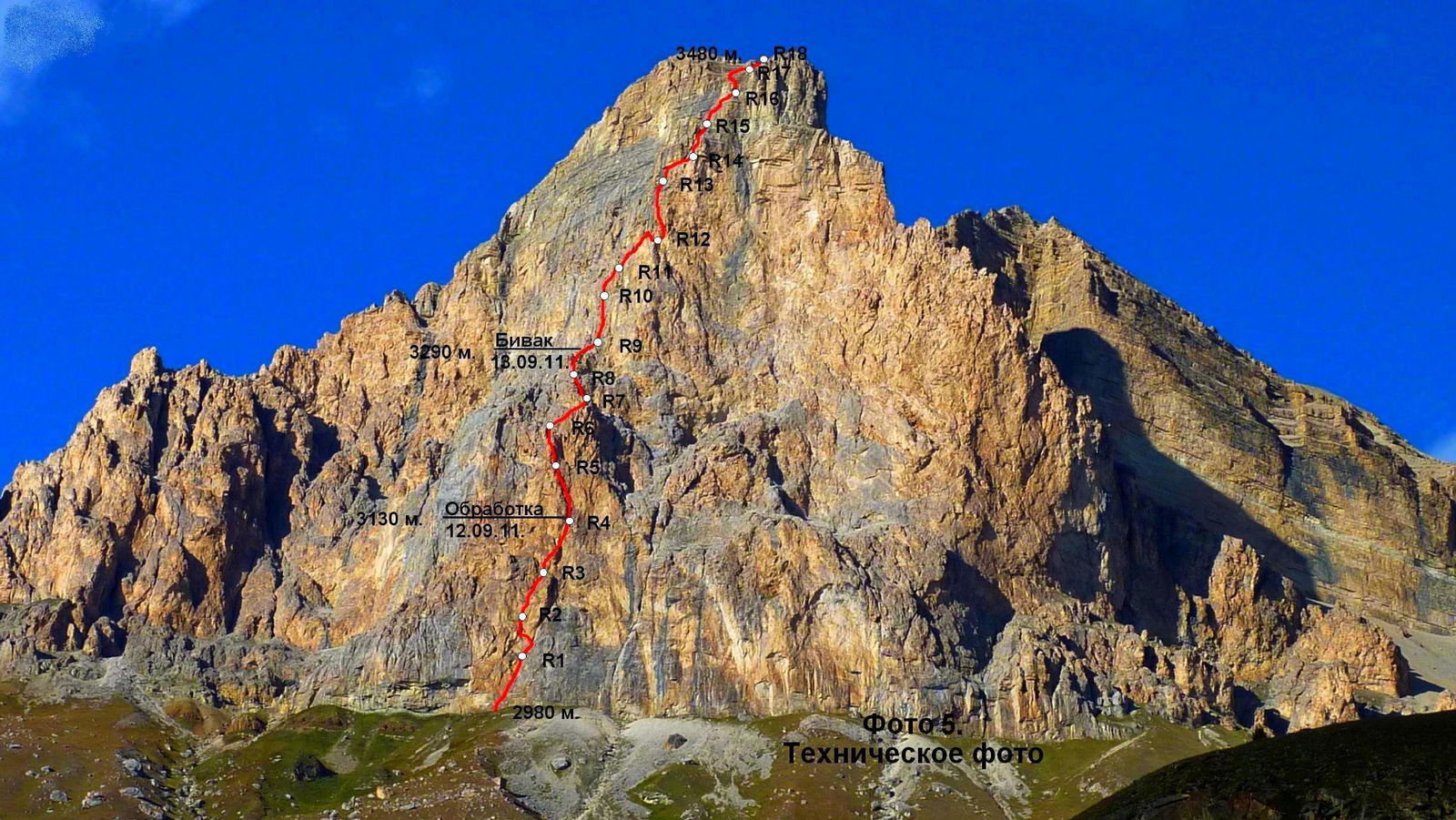
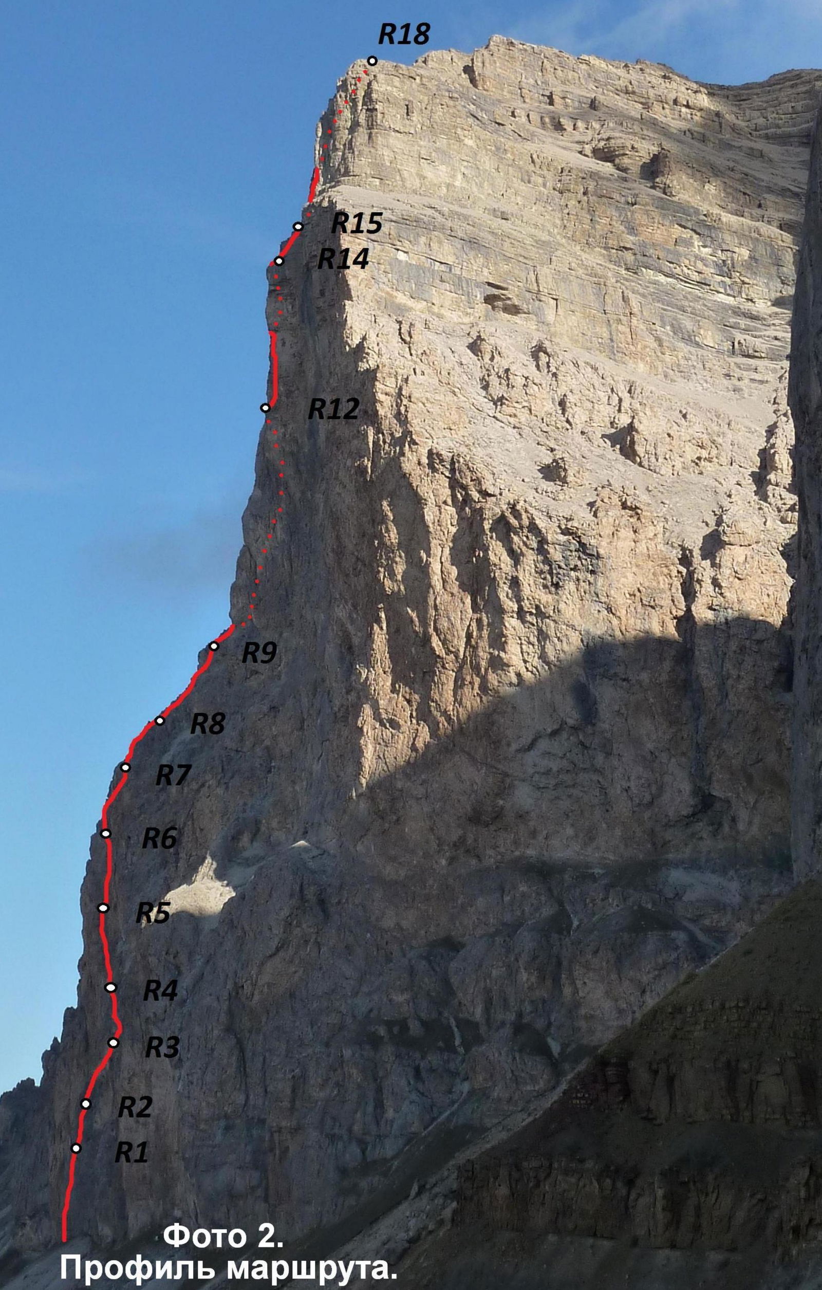
Photo 2. Route profile.
Route Profile
Scale 1:2500
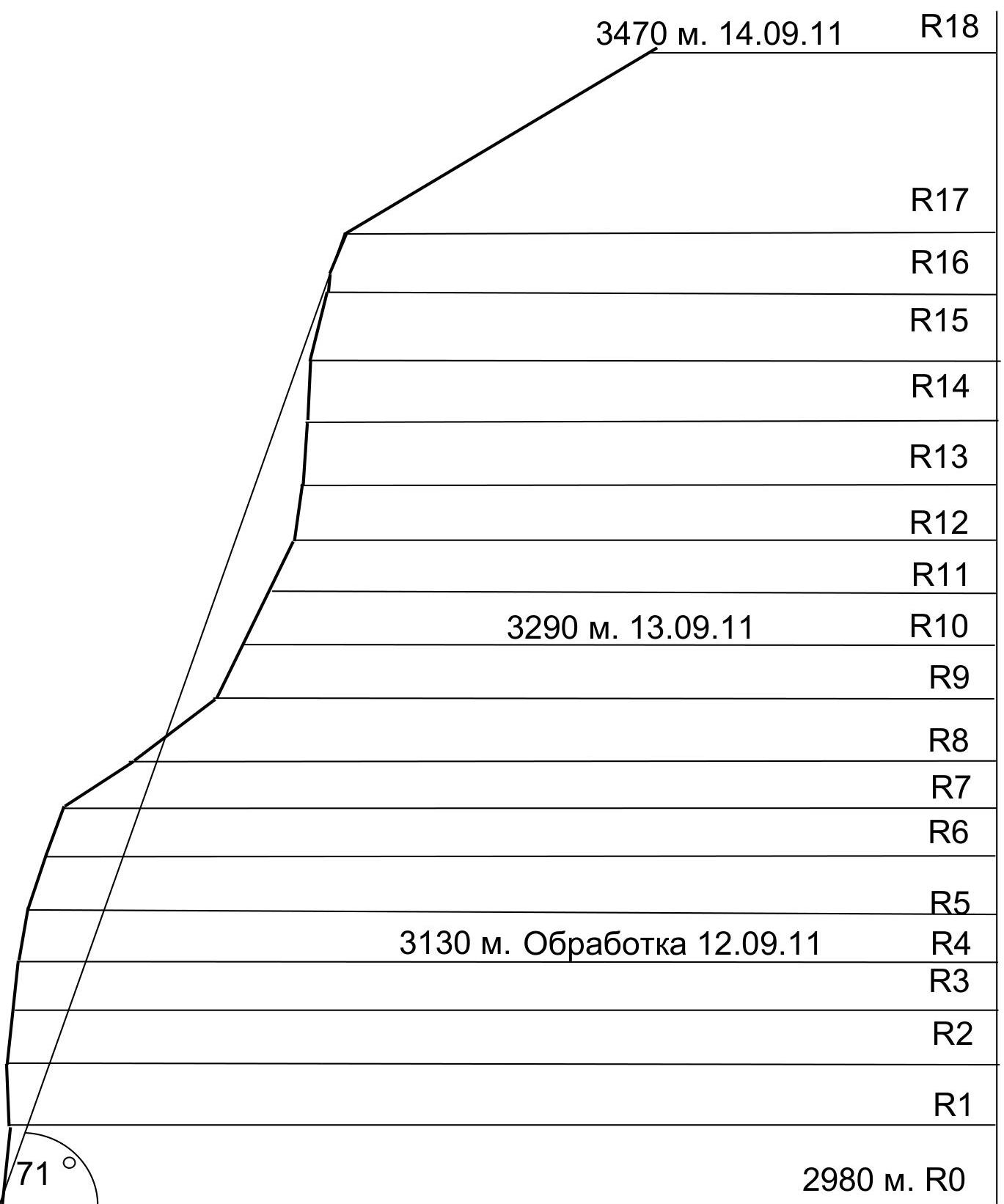
| R1–R4 | 4 | 7 | - | - | 48 | 75 | 5 | |
|---|---|---|---|---|---|---|---|---|
| R8–R9 | - | 3 | - | - | Photo 7. | 50 | 35 | 3 |
| R7–R8 | - | 2 | - | - | 50 | 30 | 2 | |
| R6–R7 | 1 | 6 | - | - | 48 | 70 | 4 | |
| R5–R6 | 4 | 7 | - | 4 | 45 | 75 | 5 | |
| R4–R5 | 5 | 8 | - | - | 48 | 80 | 5 | |
| R3–R4 | 6 | 10 | - | 4 | Photo 6. | 50 | 85 | 5 |
| R2–R3 | 6 | 8 | 3 | 40 | 85 | 5 | ||
| R1–R2 | 8 | 11 | - | 13 | 40 | 95 | 6 | |
| R0–R1 | 10 | 6 | - | 3 | 60 | 75 | 5 |
| Kara-Kaya West via Central buttress of SW wall. Presumably 5B category of difficulty. | ||||||||
|---|---|---|---|---|---|---|---|---|
| R17–R18 | 4 | 5 | - | - | 20 | 40 | 1 | |
| R16–R17 | 2 | 9 | - | - | 45 | 80 | 5 | |
| R15–R16 | 4 | 6 | - | -- | Photo 8. | 50 | 70 | 5 |
| R14–R15 | 3 | 6 | - | - | 50 | 70 | 4 | |
| R13–R14 | 3 | 8 | - | - | 50 | 85 | 4 | |
| R12–R13 | 6 | 8 | - | - | 50 | 85 | 5 | |
| R11–R12 | 2 | 5 | - | - | 50 | 70 | 4 | |
| R10–R11 | 4 | 7 | - | - | 48 | 75 | 5 |
Route Description by Sections
R0–R1. Via a diagonal crack, then along the corner. 60 m. 5.
R1–R2. Along a ledge to the left, then up a нависающему углу. 40 m. 6.
R2–R3. Via a cleft using AP, then climbing up.
R3–R4. From the belay station left, then up a small chimney. Further via a cleft, bypassing the нависание to the right. 50 m. 5.
R4–R5. Up a system of cracks. 48 m. 5.
R5–R6. Approach the internal corner, initially on the right, then on the left side, carefully up the "living" rock. Then up a cleft to a ledge. 45 m. 5.
R6–R7. Up and right onto the ridge. 48 m. 4.
R7–R8. Up the ridge. 50 m. 2.
R8–R9. Up the ridge to the base of a large internal corner. Below is a convenient spot for an overnight bivouac. 50 m. 3.
R9–R10. Up the left side, then the center of the corner, to a ledge. Belay station on the ledge. Rockfall hazard. 48 m. 5.
R10–R11. Up the left face of the corner, then via a cleft up and right. Belay station on a slanting ledge. 48 m. 5.
R11–R12. Right along a system of ledges to a finger, behind it — a belay station on a convenient ledge. 50 m. 4.
R12–R13. Along a ledge right for 8 m. Then up via a system of cracks under нависания, then traverse left. 50 m. 5.
R13–R14. Via a crack right and up to a ledge. 50 m. 4.
R14–R15. Up the right side of the corner to an осыпную полку. 50 m. 4.
R15–R16. Up and right along an inclined wall, bypassing a vertical section to the right. Belay station in an internal corner under нависанием. 50 m. 5.
R16–R17. From the station right and up along a corner, then left along the talus to a three-meter wall, then up along the talus. Belay station on monolithic rocks. 45 m. 5.
R17–R18. Via the talus reach the summit (ridge). Along the ridge ascend to the summit of Kara-Kaya West. 300 m.
Tactical and Technical Actions of the Team
The ascent was based on studying photographic materials taken in 2009 and 2010 during the passage of the Southwest bastion of Kara-Kaya peak.
When choosing the route, we settled on the central buttress of the wall. This route appeared to be the most logical and protected from rockfall. Throughout its length, the route follows the natural terrain, which allowed us to avoid using bolt pitons and artificial holes for скайхук.
The assault camp was traditionally set up under the wall of Kara-Kaya Main, 800 m to the right of the route's start. In this location, the wall has a large нависание, protecting the tent from:
- rockfall
- precipitation
Initially, our team planned to process the first bastion. This ascent tactic was dictated by:
- Changeable autumn weather
- Lack of ledges on the first bastion
- Complexity of the terrain
- Absence of water on the wall
Considering the unstable weather, we took a reserve of water, food, and gas for four days on the ascent.
According to the plan, on the first day of the ascent, we:
- Overcame 4 rope lengths of fixed ropes,
- Reached a gentle ridge between the first and second bastions,
- Began processing the second bastion.
At 19:00, we set up an overnight bivouac.
According to the plan, on September 14, 2011, at 18:30, we reached the summit of Kara-Kaya West. An hour later, we organized an overnight bivouac near the descent couloir.
The descent was carried out via the descent couloir on September 15, 2011. At 11:20, the team descended to the camp under the wall in full.
During the ascent, team members led in turns. Due to the complexity and broken terrain:
- The first climber moved on a double rope
- The rest ascended via fixed ropes with top-rope belay