JANGI (E), Eastern Counterfort - 5B cat.
The route to East Jangi-tau via the Eastern Counterfort is combined: its lower part is a rocky counterfort, the upper part is a snow-ice slope. The total length of the route is over 1600 m, the length of the rocky counterfort is 1000-1100 m. The average steepness of the rocky counterfort is 65-70°, with overhanging sections encountered on the route. The maximum steepness of the ice slope in the upper part of the route is 45-50°.
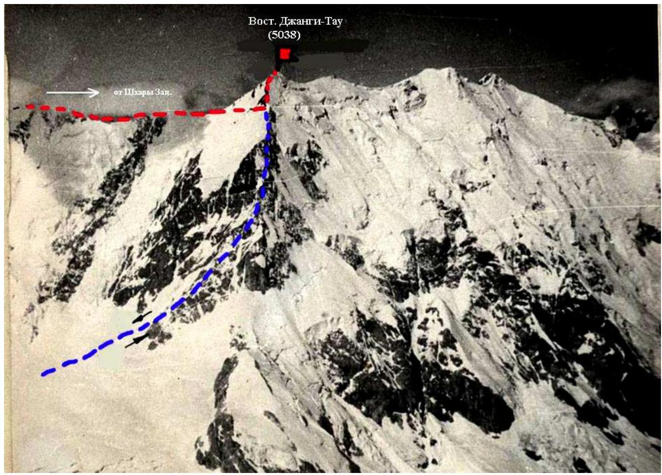
6. Description of the route by sections.

The initial bivouac is on a snow plateau under the base of the Eastern counterfort. The exit to the base of the counterfort is 120 m along a snowy slope at 40°. 40 m up the moderately difficult rocks to the base of the chimney (sect. a). The right wall of the chimney is a huge detached rock, the upper part is covered by an overhanging rock. The wall above the chimney is a continuation of its left side. The exit to the overhanging rock is 40 m either directly up the chimney (difficult climbing) or bypassing it on the right. Then there is a 15 m wall with two vertical slots.
Ascent via the right slot, then in the upper part of the wall to the left slot and exit to the top of the wall.
40 m up the internal angle with an exit to the right onto inclined slabs (sect. b).
Up the slabs to the base of a wide slot 5 m and up the slot to under a small cornice.
Through the cornice, exit onto an inclined ledge and along it 40 m to the left to the junction of two walls (the ridge of the junction sect. b is visible in the photo).
Up the ridge 40 m of extremely difficult climbing (sect. c); start of movement:
- to the right of the ridge,
- along inclined slabs to the right to the internal angle,
- up the internal angle to the start of a crack going up to the left from the right,
- then along the crack - exit to the ridge,
- up the ridge to an inclined ledge.
The further path goes along the wall to the left of the ridge 40 m up to the right (sect. d). Very small holds, few good cracks for pitons. First 20 m up to the ridge along an inclined (40°) ledge 1.5-2 m wide and then up the ridge (sect. e). Along the ridge 70-80 m (sect. f). Here it is possible to organize a semi-reclining overnight stay. Move along the rocks along steep ice with protruding rocks with an exit to the upper part of the snowy shoulder along inclined slabs 40 m, with water flowing across the slabs (sect. g). There is a place for a tent on the shoulder, but it is not safe to set up an overnight stay here as the shoulder is exposed to falling rocks and ice fragments.
The next section "h" - 40 m along a wall not visible in the photo. The first 15 m of climbing along steep (85°) smooth slab-like rocks are particularly difficult. Section "i" is the most challenging part of the route:
- Traverse up to the left 15 m to the base of the internal angle.
- Ascent up the internal angle 10 m to under a sharp rock.
- From the rock, exit with the help of ladders onto a meter-wide cornice.
- The wall above the cornice abuts a new overhanging section of rocks.
- Along the wall to the right, bypassing the second step of the cornice.
- Few holds, pitons are used for support.
- Backpacks are pulled up.
Section "k" - 70-80 m of moderately difficult loose rocks with sections of rocks. Here, on a small ledge, a sitting overnight stay can be organized.
Further:
- 40 m up (sect. l) difficult climbing along smooth rocks.
- Up to under an overhanging section of rocks.
- Along inclined slabs to the right onto the right part of the wall 40 m (sect. m).
Section "n":
- First 10 m along a smooth wall.
- Then traverse 5 m to the base of the chimney.
- Ascent up the chimney (or internal angle) 15 m.
- The chimney in its upper part abuts overhanging rocks.
- Exit from the angle to the left onto a wall and along it to the ridge.
The subsequent 100-120 m of moderately difficult rocks lead to a snowy shoulder, where there is a good place to spend the night.
From the shoulder - a path along a snowy ridge 40 m and then along moderately difficult rocks on the left part of the counterfort (150 m). Then traverse 50 m to the left, bypassing an overhanging section of rocks, to the base of an ice couloir. Ascent up the couloir 20 m and then along simple rocks on its left side another 100-120 m. Along a snowy slope with a 10-meter ice section, exit to a snowy field above the ice fall.
The further path is along a snowy slope along the NE ridge, then onto the ridge and along it to the summit of East Jangi-tau.
Descent from the summit - along the NE ridge. The first ascenders spent 36.5 hours (16.5; 8; 12) on the route and hammered in 64 rock pitons and 7 ice screws.