ASCENT DOCUMENT
-
Ascent category – combined
-
Ascent area:
- from Kitlod pass
- to Gezevcek pass
- Main Caucasian Range, from the South
-
Galaktion Tobidze Peak
Height 4000 m
Ascent route via the Southern ridge
-
Suggested category of difficulty — 3B
-
Route characteristics:
Height difference — 1660 m
Section length:
- 1st cat. diff. — 1770 m
- 2nd cat. diff. — 560 m
- 3rd cat. diff. — 400 m
- 4th cat. diff. — 50 m
- 5th cat. diff. — none
- 6th cat. diff. — none
Average steepness — 43°
-
Pitons driven: for belay — 12, for artificial holds not used
-
Total climbing hours: ascent — 8 hours, descent — 5 hours
-
No overnight stops on the route
-
Names, patronyms, surnames of the leader, participants and their qualifications:
Shkalo Valeriy Matveevich — Master of Sports of the USSR, leader
Oleynik Vladimir Valentinovich — 2nd sports category
Chingaev Sergey Nikolaevich — 2nd sports category
-
Team coach — Sabanidze Vakhtang Gelaevich
-
Date of departure and return: August 16, 1982
- first ascenders' path (A. Nemsitsveridze's group)
- route of this first ascent
In Memory of Sergo Barliani, who proposed to climb this route, dedicated
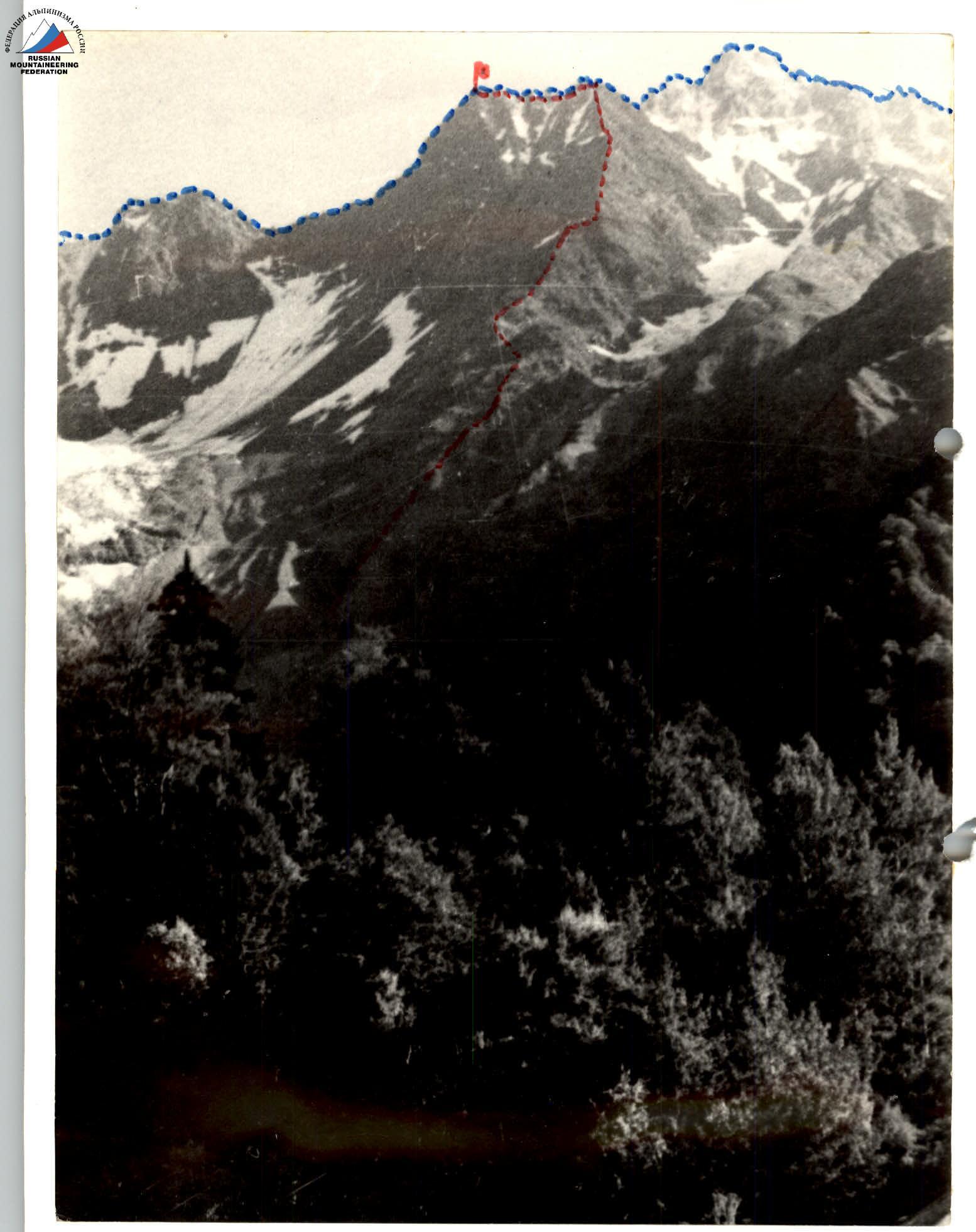
Galaktion Tobidze Peak is located in the central part of the Main Caucasian Range, between Tsurungal peak to the West and Chyornaia Neznakomka peak to the East. The ascent area is well-developed by climbers: near the peak is the "Zesho" mountaineer camp, and climbers from the "Ailama" camp also often visit.
Main routes in the area have been completed from the South. The Main Caucasian Range in this area is mostly composed of schist, heavily destroyed. Apparently, that's why Galaktion Tobidze, also schistous like Tsurungal but slightly lower, was less attractive to climbers than neighboring granite massifs of Chyornaia Neznakomka, Belaya Neznakomka, Zesho, and Ailama.
Ascent history:
- The peak Galaktion Tobidze was first conquered during the traverse of the Main Caucasian Range from Pasismta peak to Tetnuld peak in 1952 by Georgian climbers led by A. Nemsitsveridze.
- The first attempt to ascend via the Southern ridge was made by Georgian climbers in September 1973, during the climber writers' meet of Georgia, dedicated to the outstanding Georgian poet and writer Galaktion Tobidze, after whom the peak was named.
- The group of first ascenders led by Sh.M. Margiani, in difficult weather conditions and with a high snow cover on the route, managed to reach a snowy saddle in the upper part of the ridge, where they built a cairn and left a note. Further ascent was stopped due to safety concerns.
- The first ascent of the Southern ridge of Galaktion Tobidze peak was made by a group of instructors from the "Ailama" mountaineer camp on August 16, 1982.
Description of the route via the Southern ridge:
- Represents a long, steep, monotonously rising destroyed rocky ridge,
- Interrupted by snowy saddles and monolithic sections,
- Includes difficult and moderately difficult rock walls,
- Requires climbers to have certain experience moving on destroyed schistous rocks and slabs.
Ascent features:
- In rain and with snowy rocks, the route becomes significantly more complicated — rocks become slippery.
- Bypassing the route and its sections via slopes is very dangerous: destroyed rocks formed talus lying on slippery, inclined tile-like slabs — and is unlikely to be attempted.
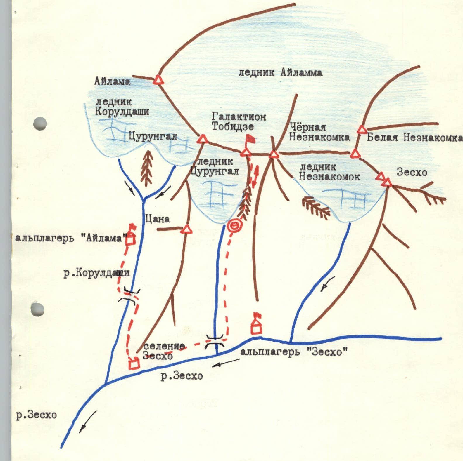
Map-scheme of the first ascent area
Brief description of the approach to the route
From "Ailama" or "Zesho" mountaineer camp, approach the village of Zesho. Turn left immediately after the bridge over the stream flowing from Tsurungal glacier, and ascend via a path up the gorge leading to Tsurungal and Galaktion Tobidze peaks, to the right of the river.
The path is initially well-defined, goes through deciduous forest, crossing two streams, then is interrupted by grass and small talus, and leads to the end of the left orographic moraine of Tsurungal glacier.
Then:
- ascend via a medium schist talus, to the right of the moraine,
- move towards the rocky Southern ridge of Galaktion Tobidze peak, the base of which is located between the aforementioned moraine to the left and the Southern ridge of Chyornaia Neznakomka peak to the right,
- separated from them by talus gullies, which may be snowy at the beginning of summer.
Under the rocky ridge, on talus, a bivouac can be set up. To the right of the ridge, a stream flows.
From Zesho village to bivouac (start of the route) — 2 hours.
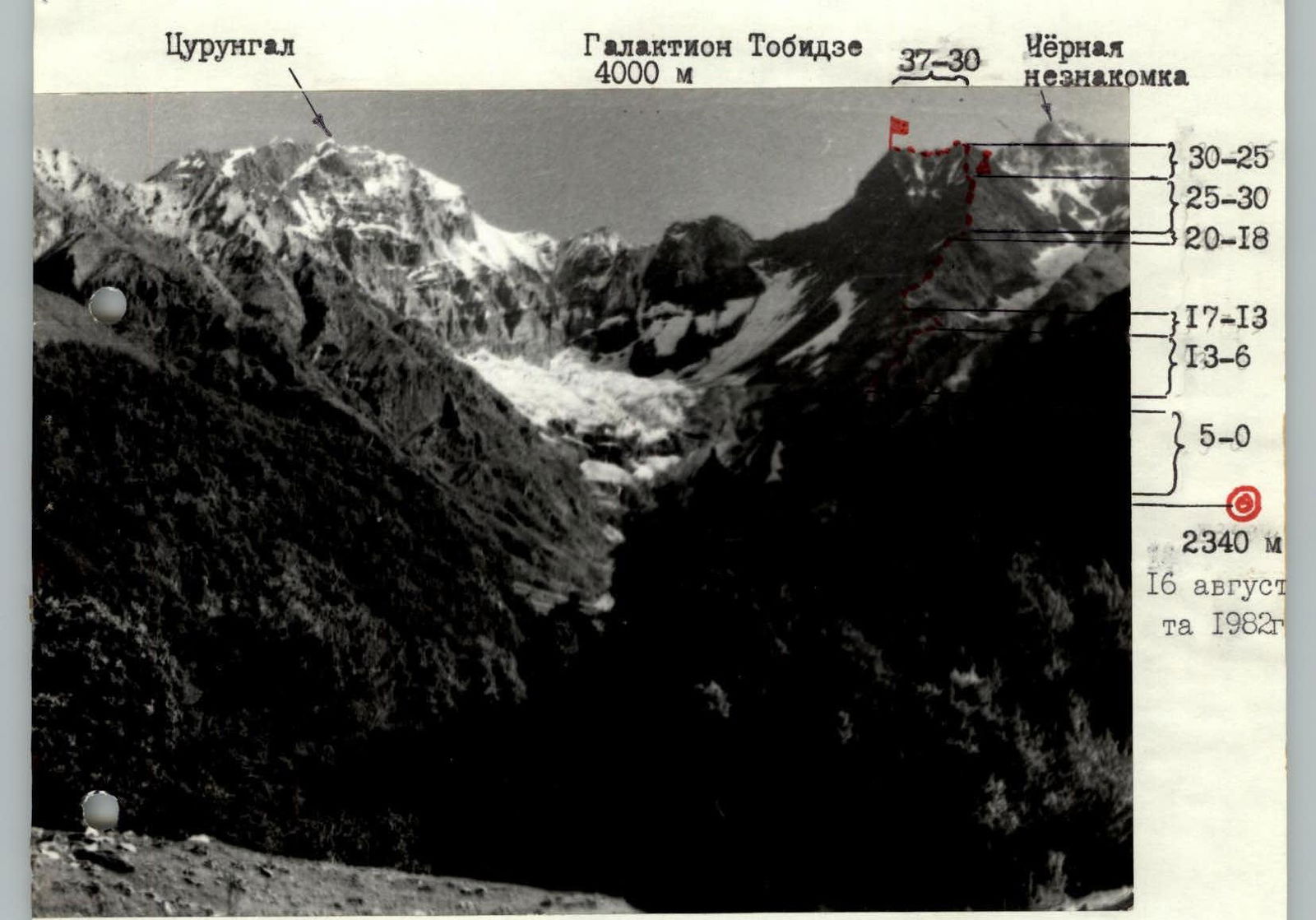
Photo of the general view of the peak. For clarity, due to dense congestion of sections, they are grouped by intervals. Sections are further shown on the profile.

Photo of the route profile
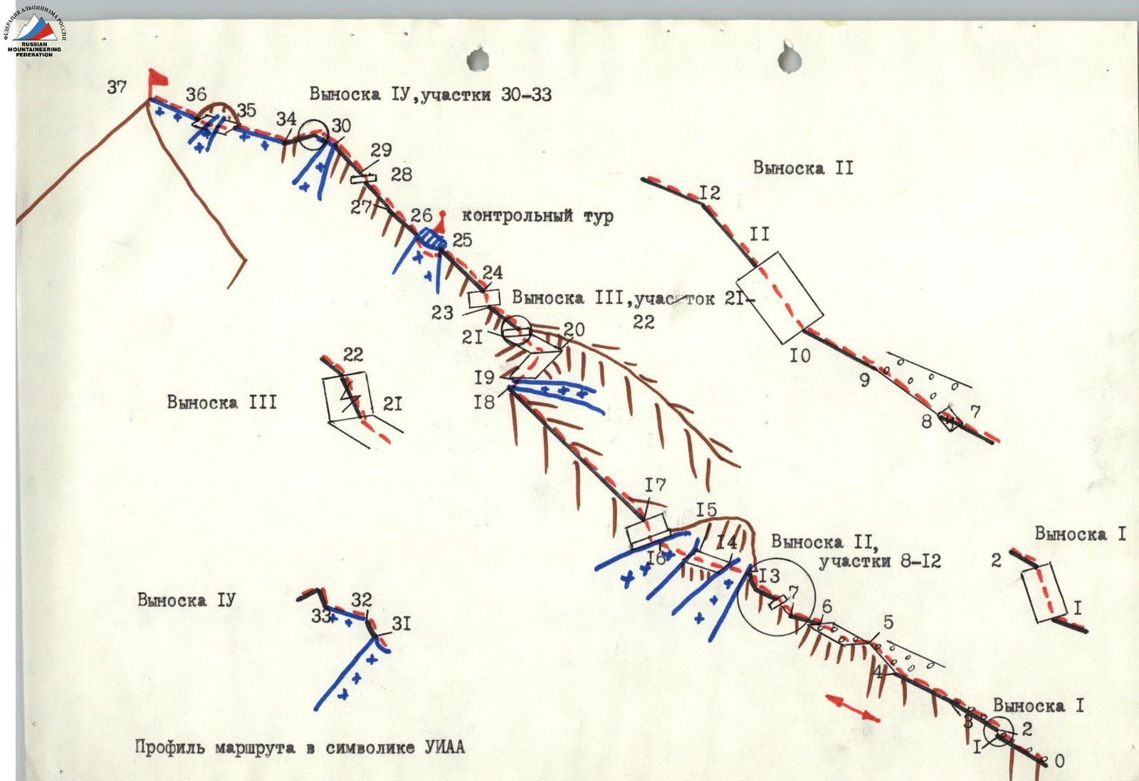
TABLE OF MAIN CHARACTERISTICS OF THE ASCENT ROUTE
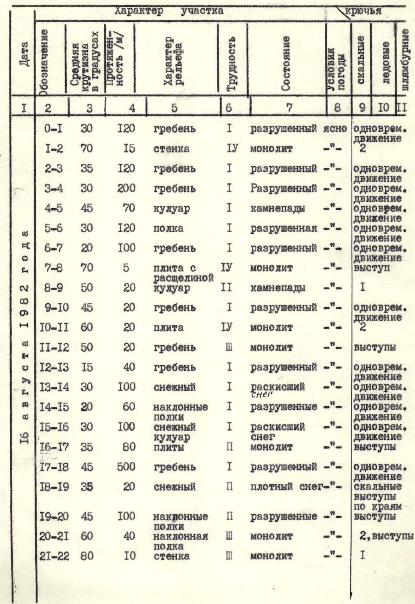
| Date | Designation | Average steepness in degrees | Length /m/ | Section type | Difficulty | Terrain type | Condition | Weather conditions | Rock pitons | Ice pitons | Bolt pitons |
|---|---|---|---|---|---|---|---|---|---|---|---|
| August 16, 1982 | R0–R1 | 30 | 120 | ridge | 1 | destroyed | clear | simultaneous movement | |||
| R1–R2 | 70 | 15 | wall | 4 | monolith | 2 | |||||
| R2–R3 | 35 | 120 | ridge | 1 | destroyed | —"— | simultaneous movement | ||||
| R3–R4 | 30 | 200 | ridge | 1 | destroyed | —"— | simultaneous movement | ||||
| R4–R5 | 45 | 70 | gully | 1 | rockfall | —"— | simultaneous movement | ||||
| R5–R6 | 30 | 120 | shelf | 1 | destroyed | —"— | simultaneous movement | ||||
| R6–R7 | 20 | 100 | ridge | 1 | destroyed | —"— | simultaneous movement | ||||
| R7–R8 | 70 | 5 | slab with crack | 4 | monolith | ledge | |||||
| R8–R9 | 50 | 20 | gully | 2 | rockfall | 1 | |||||
| R9–R10 | 45 | 20 | ridge | 1 | destroyed | —"— | simultaneous movement | ||||
| R10–R11 | 60 | 20 | slab | 4 | monolith | 2 | |||||
| R11–R12 | 50 | 20 | ridge | 3 | monolith | —"— | ledges | ||||
| R12–R13 | 15 | 40 | ridge | 1 | destroyed | —"— | simultaneous movement | ||||
| R13–R14 | 30 | 100 | snowy | 1 | soggy | snow | simultaneous movement | ||||
| R14–R15 | 20 | 60 | inclined shelves | 1 | destroyed | —"— | simultaneous movement | ||||
| R15–R16 | 30 | 100 | snowy gully | 1 | soggy snow | simultaneous movement | |||||
| R16–R17 | 35 | 80 | slabs | 2 | monolith | —"— | ledges | ||||
| R17–R18 | 45 | 500 | ridge | 1 | destroyed | —"— | simultaneous movement | ||||
| R18–R19 | 35 | 20 | snowy | 2 | dense snow | —"— | rock ledges on the sides | ||||
| R19–R20 | 45 | 100 | inclined shelves | 2 | destroyed | —"— | ledges | ||||
| R20–R21 | 60 | 40 | inclined shelf | 3 | monolith | —"— | 2, ledges | ||||
| R21–R22 | 80 | 10 | wall | 3 | monolith | 1 | |||||
| R22–R23 | 45 | 60 | ridge | 2 | destroyed | clear | ledges | ||||
| R23–R24 | 80 | 43 | wall | 3 | destroyed | —"— | ledges | ||||
| R24–R25 | 45 | 180 | ridge | 2 | destroyed | —"— | ledges | ||||
| R25–R26 | 30 | 50 | snowy ridge | 2 | dense snow | —"— | simultaneous movement | ||||
| R26–R27 | 45 | 100 | ridge | 1 | rockfall | —"— | simultaneous movement | ||||
| R27–R28 | 50 | 100 | ridge | 3 | destroyed | —"— | ledges | ||||
| R28–R29 | 90 | 5 | wall | 4 | rockfall | —"— | ledges | ||||
| R29–R30 | 50 | 120 | ridge | 3 | destroyed | —"— | ledges | ||||
| R30–R31 | 45 | 20 | snowy ridge | 3 | dense snow | —"— | belay via ice axe | ||||
| R31–R32 | 45 | 5 | ridge | 4 | icy rocks | —"— | 1 | ||||
| R32–R33 | 20 | 10 | snowy ridge | 2 | sharp, dense snow | —"— | 1 on the previous section | ||||
| R33–R34 | 45 | 40 | ridge | 2 | snowy, destroyed | —"— | ledges | ||||
| R34–R35 | 20 | 60 | snowy ridge | 1 | dense snow | —"— | simultaneous movement | ||||
| R35–R36 | 30 | 40 | shelves | 3 | intersected by ice gully | —"— | 2 | ||||
| R36–R37 | 40 | 60 | snowy ridge | 1 | dense snow | —"— | simultaneous movement |
Brief explanation of the table
From talus via simple rocks of the base of the Southern ridge of Galaktion Tobidze peak, alternating with talus (section R0–R1), to a list rock wall (R1–R2), which is climbed directly with piton belay.
Then via talus ridge (R2–R3) to destroyed rocks (R3–R4). Via them — to a talus gully. Via the left side of the gully (R4–R5, rockfall hazard!) approach a tower on the ridge and bypass it via talus shelves (R5–R6) on the left.
Via the left side of a simple ridge (R6–R7) — under a rock ascent. Climb a 5-meter slab from right to left via an inclined crack (R7–R8), to a talus gully.
Via the left side of the gully (R8–R9, rockfall hazard!) ascend to a simple destroyed rock ridge and via it (R9–R10) approach a rock ascent. Climb an inclined slab of the ascent (R10–R11) directly, then overcome 20 m of 3rd cat. diff. rocks (R11–R12) and reach a destroyed ridge.
Via it (R12–R13) traverse 40 m, then left of the ridge cross first a snowy gully (R13–R14), then via talus shelves (R14–R15) approach a second snowy gully and cross it (R15–R16). Via slabs (first 20 m, 45°, 3rd cat. diff., then 60 m, 30°, 2nd cat. diff.) ascend to a destroyed rock ridge.
Via it (120 m, 30°) — to a steeper section of the ridge (45°), then via a simple ridge (overall constitutes section R17–R18) approach a snowy gully, cross it (R18–R19) and via a rock wall (3 m), then via shelves ascend to the ridge (R19–R20) under a rock ascent. Bypass the rock ascent first on the left via an inclined steep shelf (R20–R21), then ascend via a crack in a 10-meter rock wall (R21–R22).
Via a rock ridge (R22–R23) approach a 43-meter destroyed wall, overcome it (R23–R24) and via the ridge reach a snowy shoulder.
Here — a cairn with a capsule.
Then via a snowy ridge (on the right — cornices!) ascend (R25–R26) to a destroyed rock ridge. Via this ridge (rockfall hazard!, R26–R27), which then becomes steeper (R27–R28), approach an overhanging rock wall with inclined holds and loose rocks and overcome it (R28–R29).
Then via a steep destroyed rock ridge (R29–R30) — to a snowy-icy saddle. Via it (R30–R31) — to a short icy rock ridge (R31–R32), then via a sharp snowy ridge (R32–R33) ascend to the Eastern summit.
Via a tower via rocks covered with snow (R33–R34), descend to a saddle.
Then via a snowy ridge (R34–R35) approach a second tower after the Eastern summit, which is bypassed on the left via a shelf intersected by an ice gully (R35–R36).
Then via a snowy ridge (R36–R37) ascend to the peak.
Descent — via the ascent route.