ASCENT DOCUMENT
-
Type of ascent: Rock climbing.
-
Region of ascent: Central Caucasus, Main Caucasian Range, Lower Svaneti.
-
Peak Sharitaou, 3699 m, Southern ridge, rock climbing.
-
Proposed category of difficulty: 3B.
-
Route characteristics: 300 m elevation gain, average slope 20°.
-
Pitons hammered: 24 rock pitons.
-
Time taken to complete the route: 8 hours.
-
Number of nights stayed: None.
-
Leader of the ascent:
Stefanovich Alexander Vasilievich, Candidate for Master of Sports, Instructor-Methodologist category III,
Team members:
- Kritsky Andrey Nikolaevich — III rank
- Pirogov Alexander Vyacheslavovich — III rank
- Saybatatov Rustam Khaydarovich — III rank
- Alexandrov Nikolay Andreevich — III rank
- Petukhova Marina Viktorovna — III rank
-
Coach: Kelekhsashvili Jemal Lungenozovich, Master of Sports of the USSR, Instructor-Methodologist category I, Head of the training department of the alpine base.
-
Date of departure and return: August 26, 1986.
-
Organization: Alpine training and sports base "Zesho".
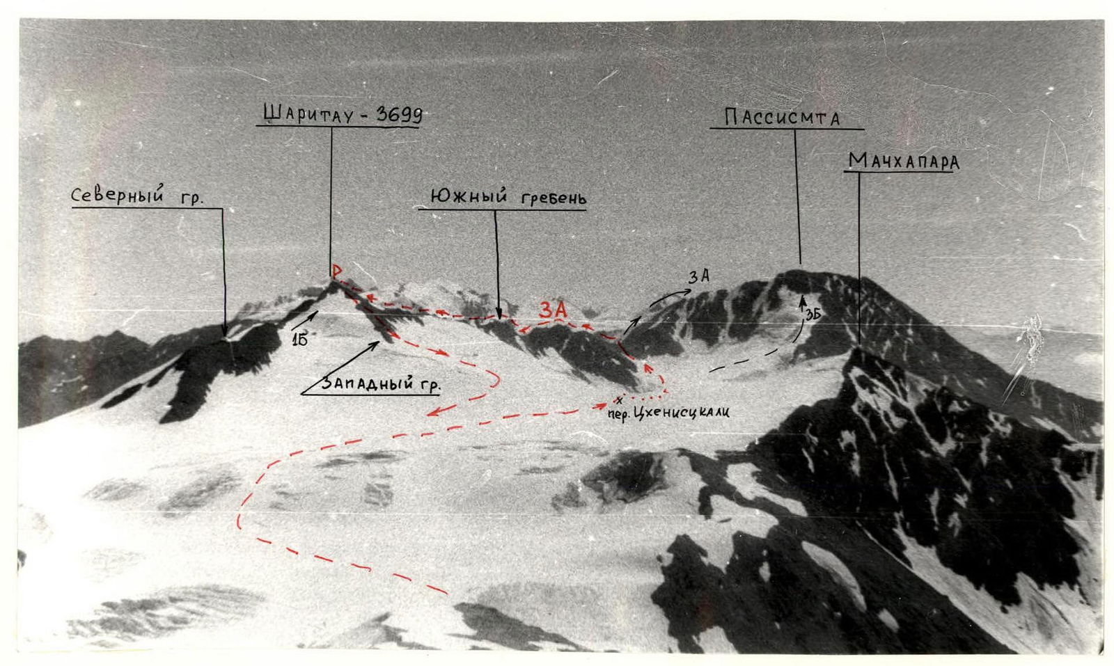
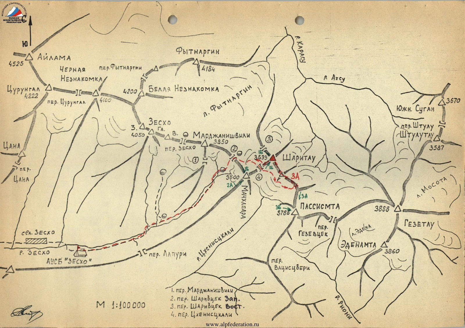
- Marjanishvili Pass
- Shariwcek West Pass
- Shariwcek East Pass
- Tskhenistsqali Pass at the start of the ascent route to the peak Sharitaou (3699 m) via the Southern ridge
DESCRIPTION OF THE APPROACH
to the start of the ascent route to the peak Sharitaou (3699 m) via the Southern ridge
From the "Zesho" alpine base, go up the road to the lower grounds (geologists' hut) and continue in the same direction along the left (in the direction of travel) bank of the river. After 1 km, cross the river via a footbridge or ford and reach a snowfield covering the riverbed. Before reaching the end of the snowfield, move left onto a grassy-talusslope and approach the waterfalls. Then, follow a rocky trail strewn with small stones, ascending to the left of the waterfalls. After passing the waterfalls, the trail crosses two river branches. Continue along a wide grassy slope via a serpentine path to reach the upper grounds. The journey from the alpine base takes 3–4 hours.
From the grounds, follow a trail to the right of a large boulder towards Shariwcek West Pass (30–40 minutes). The ascent to the pass is steep, via talus shelves, requiring attention to avoid dislodging stones. On the pass, there are convenient bivouac sites on the rocks to the left.
From the pass, the white pyramid of peak Sharitaou is visible. It is recommended to rope up and descend to the eastern branch of the Fytnarqin glacier, then move along its flat section towards peak Sharitaou. When the glacier starts to rise sharply upwards to the right, head east along this rising section. Upon leveling with a rocky outcrop to the left, turn right and ascend along the western slopes of the Northern ridge of peak Sharitaou, gaining elevation. Shariwcek East Pass remains to the left. Navigate around crevasses with a slight gain in elevation to reach a wide, flat saddle between peaks Sharitaou and Machkhapara — this is Tskhenistsqali Pass. The journey from Shariwcek West Pass takes 1–1.5 hours.
From Tskhenistsqali Pass, a steep descent leads to the Tskhenistsqali glacier. Continuously moving left, follow along the Southern ridge of Sharitaou (in some areas, piton belays are necessary). It is recommended to wear crampons. The path passes close to the Western counterfort of the Southern ridge and leads to a gentle part of the glacier. Then, proceed in the direction of Passismta peak until the terrain starts to rise. Turn left and ascend to the lowest saddle on the Southern ridge of Sharitaou. This is the rightmost depression in the ridge. The journey from Tskhenistsqali Pass takes 2 hours. From here, two routes begin: to Passismta peak via the Northern ridge (category 3A) and to Sharitaou peak via the Southern ridge (proposed category 3A).
DESCRIPTION OF THE ASCENT ROUTE TO SHARITAOU PEAK VIA THE SOUTHERN RIDGE
From the grounds at the lowest section of Sharitaou's Southern ridge, proceed along the ridge via talus and heavily fractured rocks. Overcome 4 minor gendarmes via their faces (see diagram) and damaged rocks directly, approaching the fifth gendarme. The ascent to it is via an inclined ledge of moderate difficulty. On the gendarme, there is a control cairn.
After passing another gendarme (requiring particular attention during descent due to significant damage), reach the pass saddle. Here, there is a tourist control cairn when transitioning from the Karasu river valley to the Tskhenistsqali river valley.
From the pass, a long ascent begins via gentle and uncomplicated rocks to the seventh gendarme. In the upper section of the gendarme (which can be considered a separate peak), there are 12–15 m of complex rocks, followed by a traverse to the left with piton belays, just before reaching the summit. Be cautious of many loose stones and slabs!
On the col between gendarmes VII and VIII, there is a snowfield. It is recommended to pass it on the left. Gendarme VIII is overcome directly, via a 15–17 m wall of rocks of moderate complexity, heavily damaged. 5–7 m before reaching the summit of the gendarme, traverse left along an inclined slab strewn with small stones and sand, using piton belays!
Head towards a characteristic depression in the rocks resembling a "claw." Climb through the "claw," and beyond it is a good location for organizing belays, allowing the group to gather together.
The descent from gendarme VIII is along the edge of rocks and snow to the col (approximately 200 m). The path then continues upwards. Overcome 4 more gendarmes via short, steep 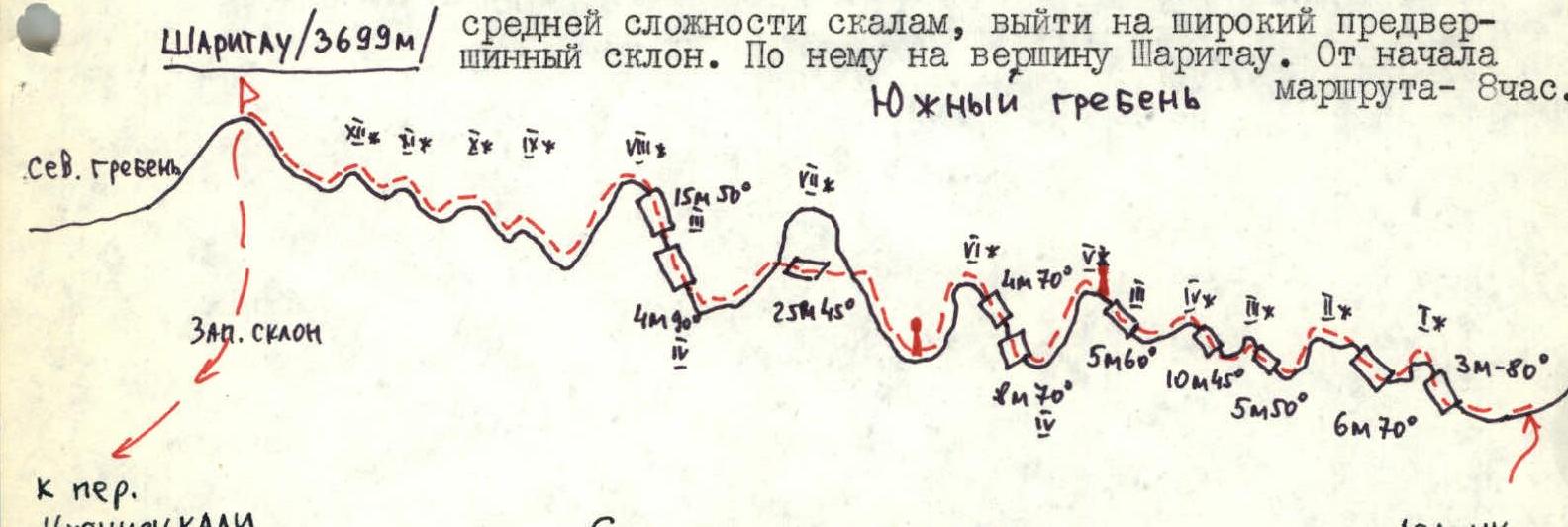 rocks of moderate complexity to reach a broad pre-summit slope. From there, ascend to the summit of Sharitaou (3699 m). The journey from the start of the route takes 8 hours.