
- Tsurungal via the West Face (combined route, V. Gabelashvili, grade 4A, fig. 5, 12).
From the "Ailama" alpine camp, follow the trail up the gorge along the left bank of the Koruldashi River. Above the point where the second stream of the Koruldashi Glacier merges into the river on the right, cross the river and follow the trail on the left side of the large green moraine to reach the lower plateau of the Koruldashi Glacier. It takes 1–1.5 hours from the alpine camp.
On the glacier, make your way to the right side of the ice-and-snow slope with rockfall in the upper part, descending from the Tsurungal saddle on the Main Caucasian Range between Ailama and Tsurungal.
From the glacier, having overcome the bergschrund:
- 200–250 m up and to the right (loose rocks) along the steep broken ice-and-snow slope below the rock walls of Tsurungal's West Face.
- From the slope, follow the rocks above — a 35–40-meter ascent up a moderately difficult rock wall onto the West Face.
Then, ascend 800–1000 m (loose rocks) along severely damaged steep moderately difficult ridges and scree-filled snow-covered couloirs with short difficult rock walls to reach the NW summit ridge and follow it to the summit of Tsurungal.
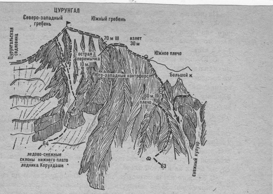
Fig. 12.
Comments
Sign in to leave a comment