
Report
On the ascent to the summit of Elbrus Eastern 5621 m.
from the east through the Achkeryakolsky lava flow
Presumably 2A category of complexity
Leader: Gavrilov Ilya Vladimirovich
2010 Addresses: 357500, Stavropol Territory, Pyatigorsk, Ogorodnaya st., 37-3, apt. 26 Gavrilov Ilya Vladimirovich, tel. +7-928-829-10-41, djilisutours@rambler.ru 357600, Stavropol Territory, Essentuki, Ordzhonikidze st., 84-3, apt. 43 Mashin Roman Ivanovich, tel. +7-928-285-57-46, romashin79@mail.ru 357700, Stavropol Territory, Kislovodsk, Olkhovskaya st., 14, apt. 1 Ovcharenko Danila Sergeevich, tel. +7-928-008-03-01, ovcharenko911@mail.ru
Ascent Passport
- Caucasus, KBR, Zolsky district, Lateral ridge, section 2.4. From the Chiperezau pass to the Gumachi peak
- Summit: Elbrus Eastern 5621 m.
- Proposed: 2A category of complexity, repeated ascent
- Route type: combined
- Route length: 6800 m. Section lengths:
- 1 category of complexity — 5700 m.
- 2 category of complexity — 1100 m.
- 3 category of complexity — 0 m.
- 4 category of complexity — 0 m.
- 5 category of complexity — 0 m.
- 6 category of complexity — 0 m. Average slope: critical part of the route — 30°; entire route — 25°.
- Used belay points: Total: 5 Belay points left on the route: none
- Team's travel hours: 16 hours, 3 days
- Leader: Gavrilov I.V. CMS Participants:
- Mashin R.I. 2nd sports category
- Ovcharenko D.S. 3rd sports category
- Coach: Gavrilov I.V.
- Route started: June 9, 2010 Reached the summit: June 11, 2010. Descended to Base Camp: June 12, 2010 Descent from the summit: via the ascent route
- Organization: independent
- Responsible for the report: Donskov A.M.
tel. +7-962-017-82-09, donskov91@mail.ru
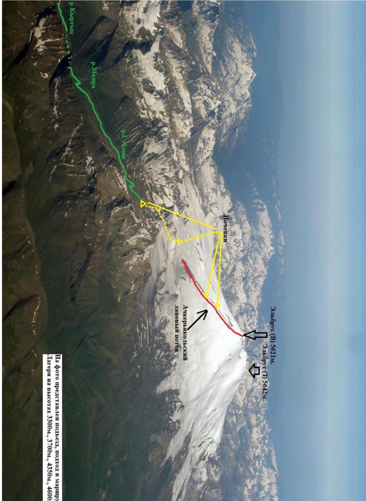 The photo shows the approach, ascent route, and camps at altitudes of 3300 m, 3700 m, 4350 m, and 4600 m.
 Overview of the Elbrus ascent area: a double-peaked stratovolcano in the Lateral ridge, with heights:
- 5642 m (western)
- 5621 m (eastern) Thus, the western summit of Elbrus is the highest point in Russia. The first ascent is considered to be that of Kilar Khashirov on July 22, 1829, as part of an expedition led by General Emmanuel G.A. There are 7 classified routes to the Elbrus summits, among which the most popular are those passing along the southern and northern slopes. The western slopes of the summit are the most inaccessible, and some of the most technically challenging ascent lines in the Caucasus are found here. The technical part of the ascent to Elbrus from the east begins from the Irikchat pass (3667 m). There are several ways to reach Irikchat pass:
- Traditionally, this is an ascent from the Elbrus settlement and further up the Irik river to Irikchat pass (~ 15 km).
- Ascent from the "Jilysu" thermal springs, to which an asphalt road was built in 2012 (~ 11 km).
- The fastest option (with the use of high-clearance vehicles) is considered to be the ascent from the Subashi river valley through the Chatkara pass (3557 m) and further through the Djikaugenkhez glacier to Irikchat pass. There is a dirt road along the Subashi river valley (from the Upper Baksan settlement) up to an altitude of 3400 m, which ends at an old geological adit a kilometer from the Chatkara pass. From the adit to Irikchat pass ~ 5 km. Mobile phone coverage in the Irikchat pass area is unstable; the most stable signal is from the "Megafon" network.
Description of the approach to the route We will describe the option of reaching Irikchat pass through the Kyrtyk and Subashi river valleys. In the Upper Baksan village, turn left at the bridge over the Syltransu river onto a dirt road that winds uphill along the Kyrtyk river. Continuing along the main channel of the Kyrtyk river, we reach a wide (2 km) field, at the end of which the road, making two sharp turns, leads us into the Subashi river gorge (at the fork, after the second turn, keep left). Here, the confluence of the two rivers, Subashi and Mkara, forms the Kyrtyk river. Along the Subashi river, the road leads to an old geological adit. The altitude here is 3232 m. There is no road further. From Upper Baksan ~ 25 km. The road is suitable for vehicles like UAZ, Niva, and takes about 3 hours. It is possible to set up a camp here; there is water available at any time of the year. From here, it is possible to ascend to the Djikaugenkhez pass (3572 m) or to the Chatkara pass (3557 m), separated by a small elevation. From the adit ~ 1 hour. Descent from the pass onto the Djikaugenkhez ice plateau and further along the slopes of Chatkara mountain to Irikchat pass or to overnight camps under the "red hill". From Chatkara pass 2 hours.
Route description R0–R1. From Irikchat pass, at the foot of the "red hill", movement in rope teams across the closed glacier towards the beginning of the Achkeryakolsky lava flow. R1–R2. Exit onto the Achkeryakolsky lava flow via a steep talus slope and further up the snowy-talus slope of the lava flow to good camping sites. Altitude ~ 4600 m. R2–R3. From the camps, movement along a gentler snowy slope towards the lateral crater, exiting onto the lava flow that bypasses the lateral crater on the right. R3–R4. Up the steep talus slope, exit above the lateral crater. Depending on the snow and ice conditions in this section, ice or hard firn may be encountered. In such cases, the organization of belays is mandatory. R4–R5. Along a more gentle slope, movement in the direction of a visible rock and bypassing it on the right, exit into the crater of the eastern summit of Elbrus. This is the highest point. Descent was made via the ascent route, on skis.
| Section | Length | Slope | Terrain type | Category of complexity |
|---|---|---|---|---|
| R0–R1 | 1600 m | 5° | Closed glacier | 1 |
| R1–R2 | 3000 m | Up to 20° | Snow, talus slope | 1 |
| R2–R3 | 300 m | Up to 10° | Snow | 1 |
| R3–R4 | 1100 m | Up to 35° | Talus, Snow, Ice | 2 |
| R4–R5 | 800 m | Up to 20° | Snow, talus slope | 1 |
Conclusions and recommendations for the route Recommended for groups with knowledge and experience in movement and belay organization on несложном горном рельефе. The route is predominantly combined and, depending on the time of ascent, may contain extended ice sections. Special attention should be paid to the descent from the summit:
- In conditions of poor visibility and without a recorded GPS track, stay on the lava flow.
- Be cautious of exiting onto the lateral crater's drop-offs.
The route corresponds to the specified category of complexity and represents a more challenging option for ascending Elbrus (E) compared to routes passing along the southern and northern slopes of Elbrus.
Team at the summit
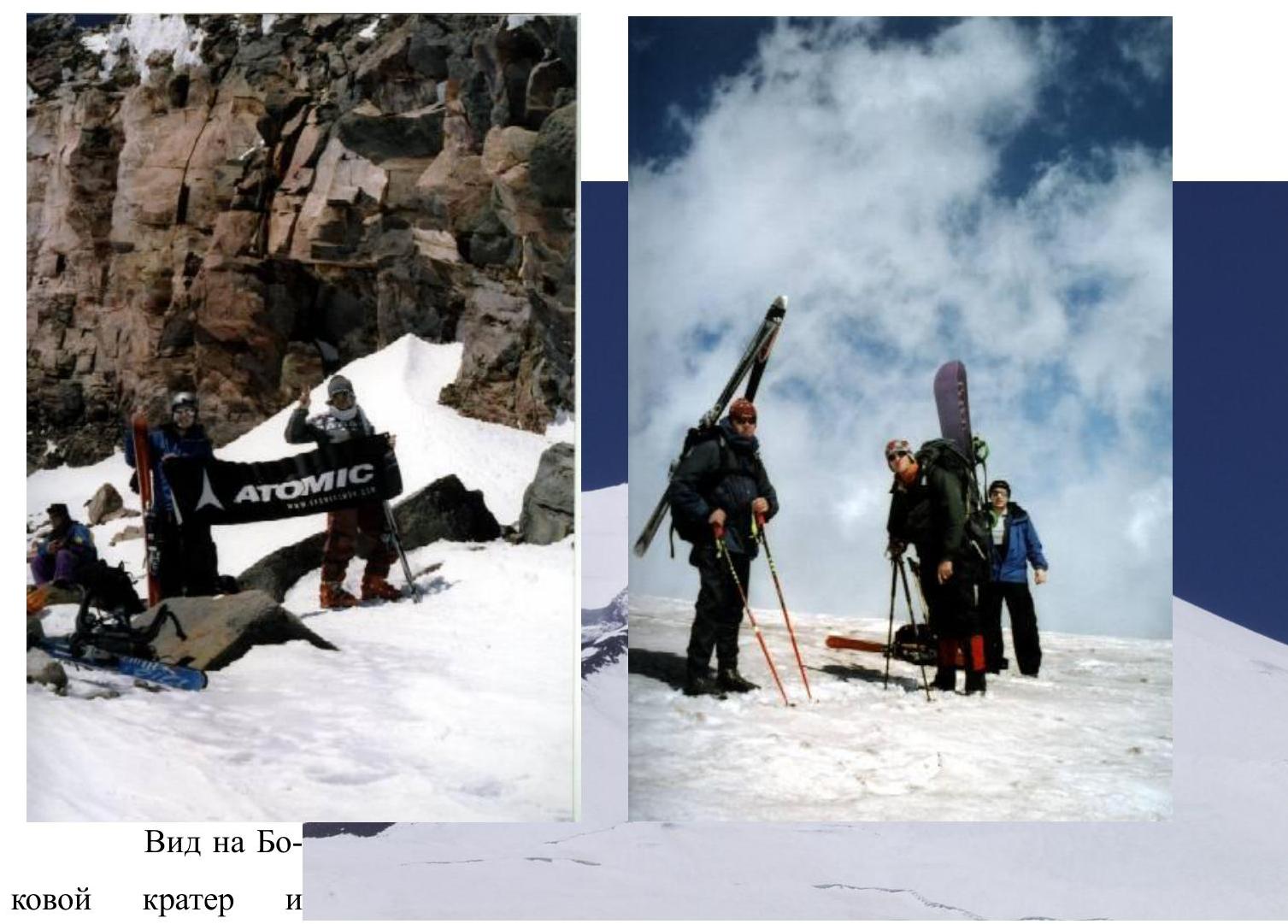 View of the lateral crater and the upper part of the lava flow
 Camps on the Achkeryakolsky lava flow at an altitude of 4350 m.
Comments
Sign in to leave a comment