REPORT
ON COMPLETING THE TRAVERSE OF SOUTHERN USHBA – NORTHERN USHBA 6A DIFFICULTY LEVEL BY THE TEAM FROM NIU MGSU FOR THE PERIOD from August 28 to September 2, 2023 Route "Krasivyy" 2023
1. Climbing Report
| 1. General Information | ||
|---|---|---|
| 1.1 | Leader's Full Name, Sports Rank | Prostakishin Dmitriy Aleksandrovich |
| 1.2 | Participants' Full Names, Sports Ranks | Zherdev Kirill Valer'evich; Komarov Pavel Fedorovich; Sayfullin Il'dar Rufatovich. |
| 1.3 | Coach's Full Name | |
| 1.4 | Organization | NIU MGSU |
| 2. Characteristics of the Climbing Object | ||
| 2.1 | Region | Central Caucasus. Svaneti. Georgia |
| 2.2 | Name and Height of the Peak | Ushba South 4710 m above sea level; Ushba North 4690 m above sea level. |
| 3. Characteristics of the Route | ||
| 3.1 | Route Name | Route "Krasivyy". Traverse of peaks: Ushba South. Via the left part of the Southwest wall (L. Myshlyaev, 1960 ) 4710 m – Ushba North 4690 m. |
| 3.2 | Proposed Difficulty Level | 6A |
| 3.3 | Route Exploration Level | - |
| 3.4 | Route Terrain Type | Combined |
| 3.5 | Route Elevation Gain (altimeter or GPS data) | 2000 m. Glacier – South Ushba Peak 1700 m, North Ushba 300 m. |
| 3.6 | Route Length (in meters) | 4910 m. Glacier – South Ushba Peak: total 2910 m, wall part 1310 m. South Ushba – North Ushba: 2000 m. |
| 3.7 | Technical Elements of the Route | Length of sections with 5–6 difficulty level – 650 m. |
| 3.8 | Average Steepness of the Route, (°) *(2) | 75° |
| 3.9 | Descent from the Peak | Via 4A difficulty level through Ushba Cushion |
| 3.10 | Additional Route Characteristics | Georgian shelf – water was absent, in other places snow was present. |
| 4. Characteristics of the Team's Actions | ||
| 4.1 | Time of Movement (team's walking hours, in hours and days) | 5 days |
| 4.2 | Overnight Stays | Bivouac shelters |
| 4.3 | Route Processing Time *(3) | - |
| 4.4 | Departure onto the Route | 05:17 August 28, 2023 |
| 4.5 | Arrival at the Peak | South Ushba – 07:50 August 31, 2023 ; North Ushba – 08:10 September 1, 2023 |
| 4.6 | Return to the Base Camp | 11:20 September 2, 2023 |
| 5. Report Responsible | ||
| 5.1 | Full Name, e-mail | Zherdev Kirill Valer'evich, PPE_EXPERT@MAIL.RU |
2. Climbing Description
2.1. Characteristics of the Climbing Object
2.1.1. General Photo of the Peak
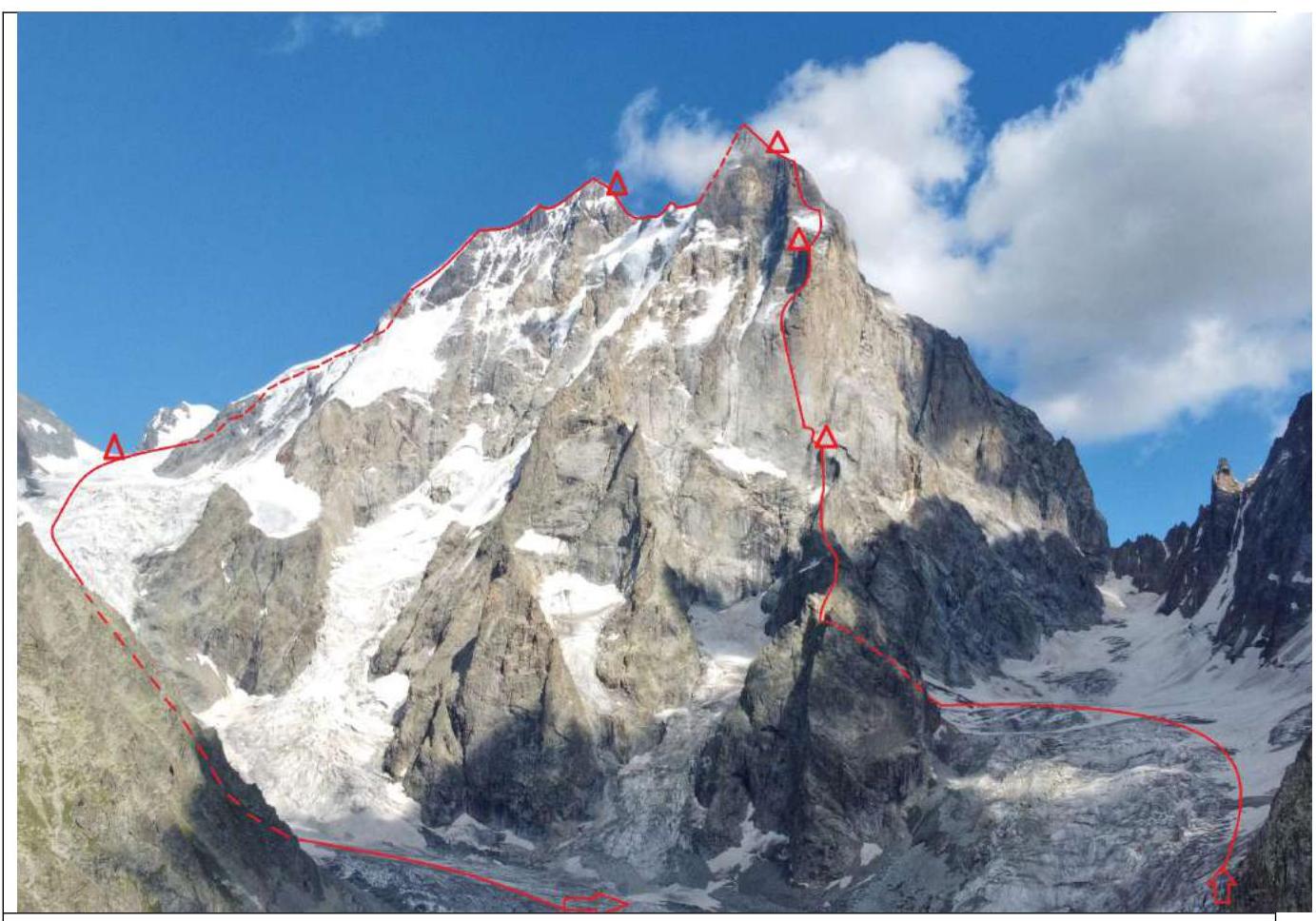
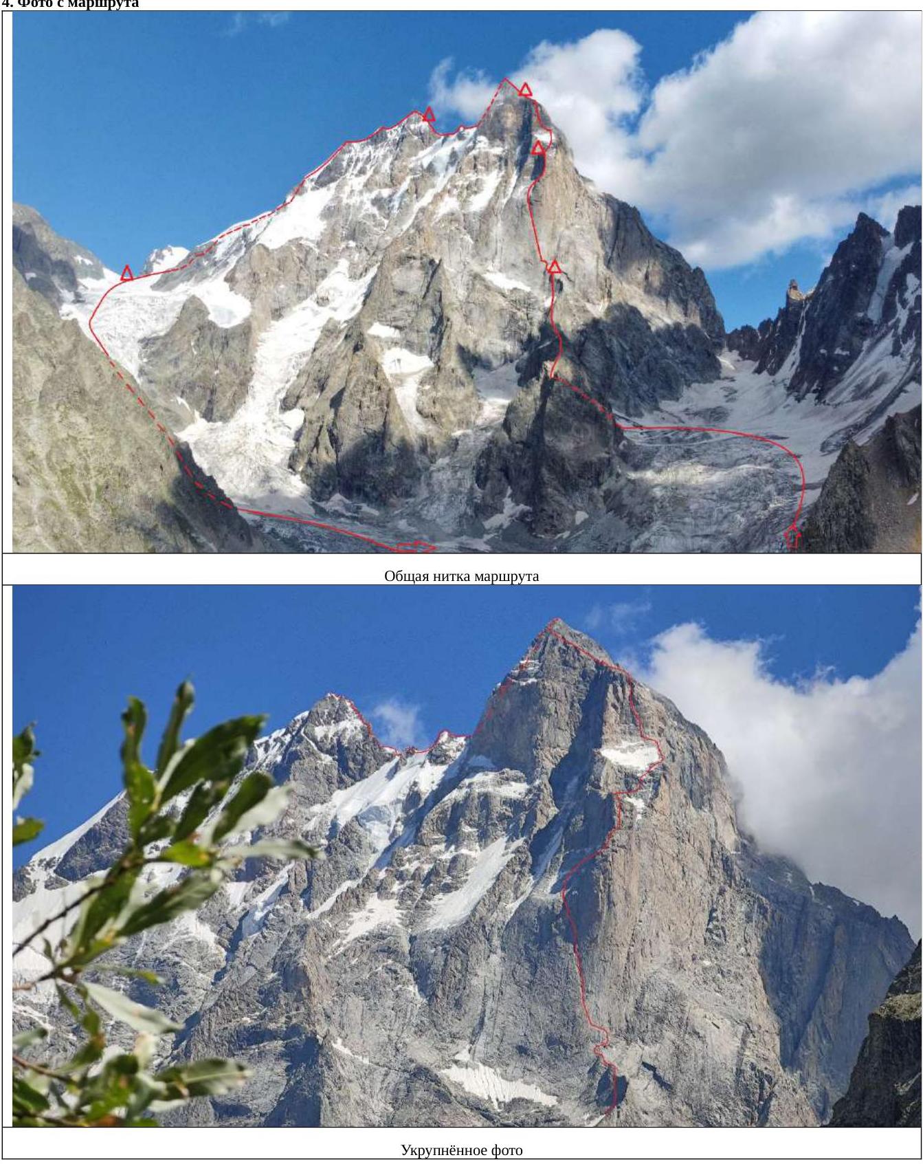
Figure 1. Route thread. Starting via the left part of the Southwest wall (L. Myshlyaev, 1960 ) 4710 m – then traverse to South Ushba via the saddle and descent via the classic route 4A difficulty level.
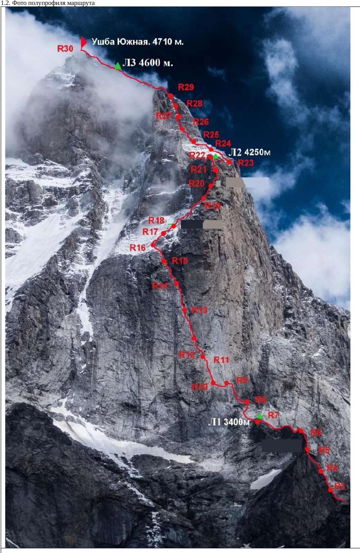
Figure 2. Semi-profile with technical notations of sections of the route to the peak of South Ushba 4710 m. (photo taken from the report of FAiS Kiev and modified)
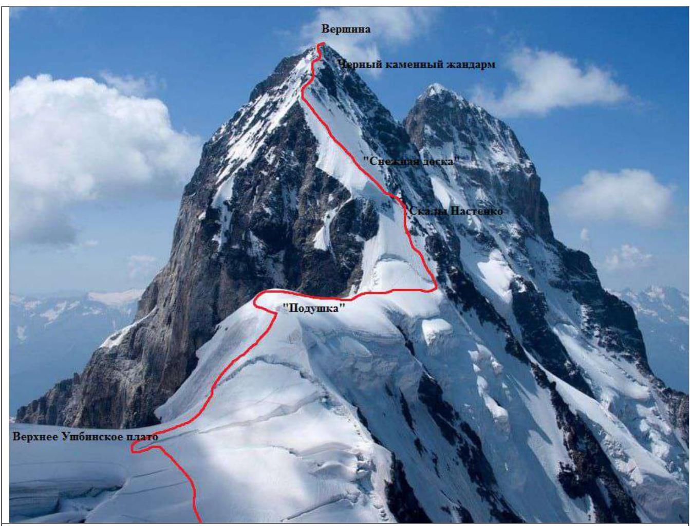
Figure 3. Photo of the route with a description of the main sections on North Ushba. (photo taken from the Risk.ru website)
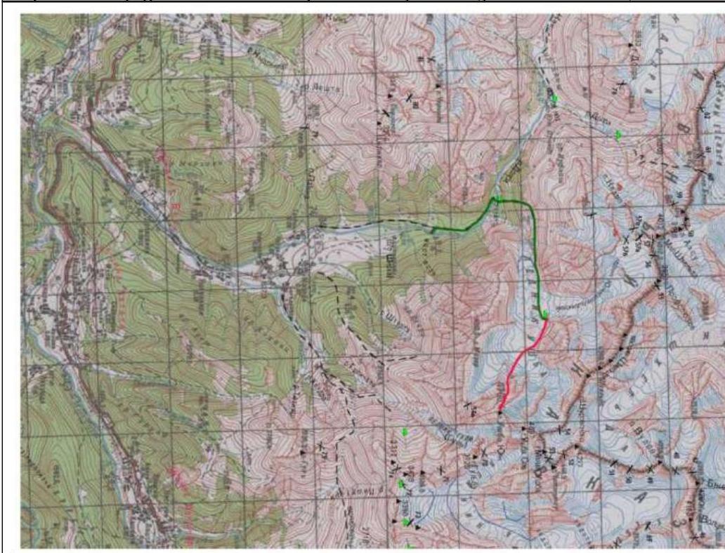
Figure 4. Topographic map of the area
2.2. Characteristics of the Route
2.2.1. Scheme of the Main Complexity Part of the Route in UIAA Symbols
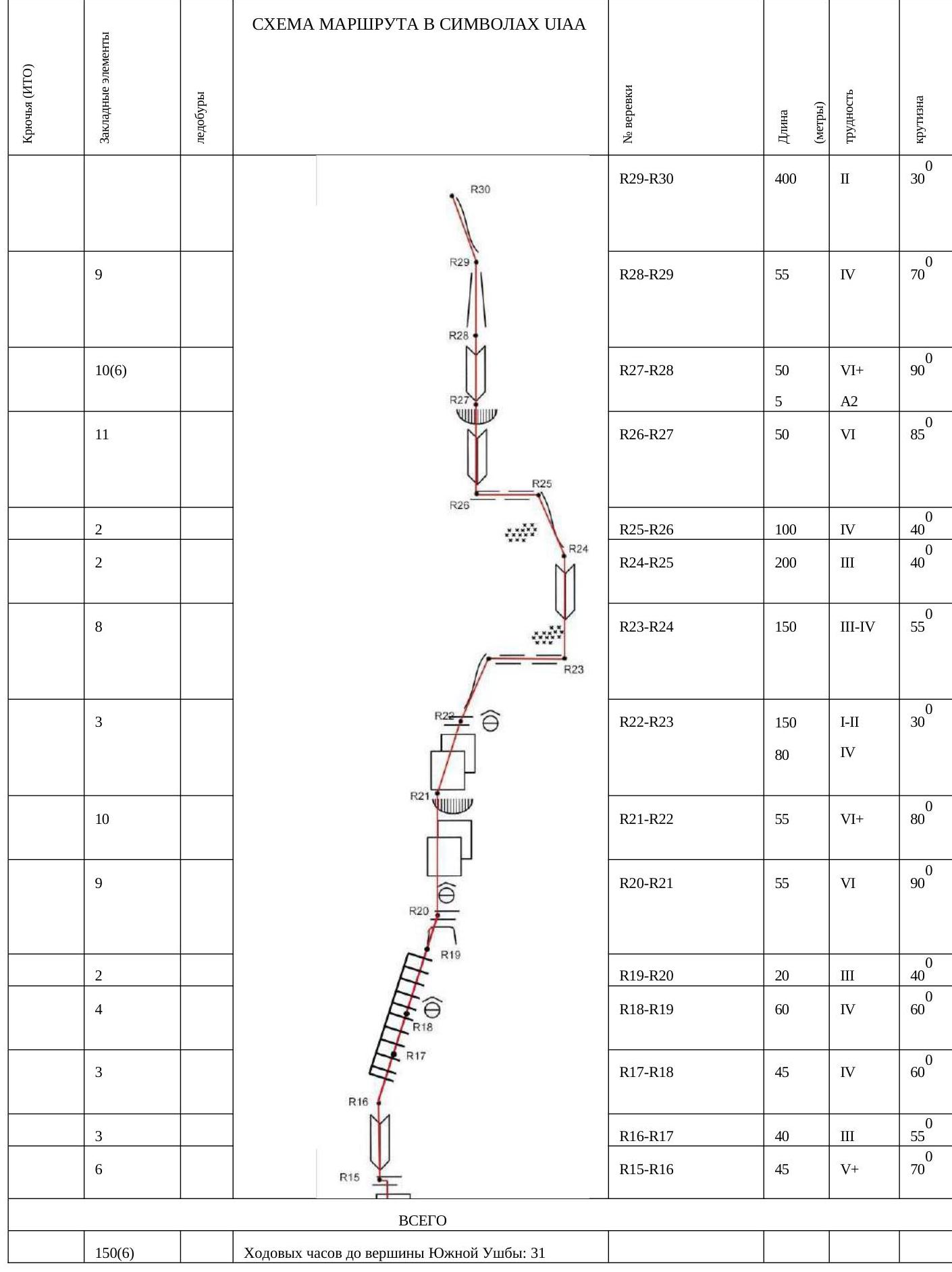
2.2.2. Route Description by Sections
Approach to BC: from Mazeri village via a good dirt road to the bridge over the Dolra River. There is a border post beyond the bridge. A permit is required, which is obtained in Becho. From the outpost, follow the marked trail through the forest and meadows to the tongue of the Ushbin glacier. Along the large scree and moraines, keeping to the right side, turn towards the Mazeri Tooth and reach the snowy plateau of the glacier descending between Mt. Mazeri and South Ushba. A BC and a cache for excess equipment can be set up there. Approach to the start of the route: from the BC bivouac, cross the glacier fall along the Mazeri Tooth towards the Southwest ridge. The location is chosen depending on the situation. Abundant rockfall is possible from the slopes of Mazeri. From the snowy plateau of the glacier, approach the destroyed slope of the Southwest ridge.
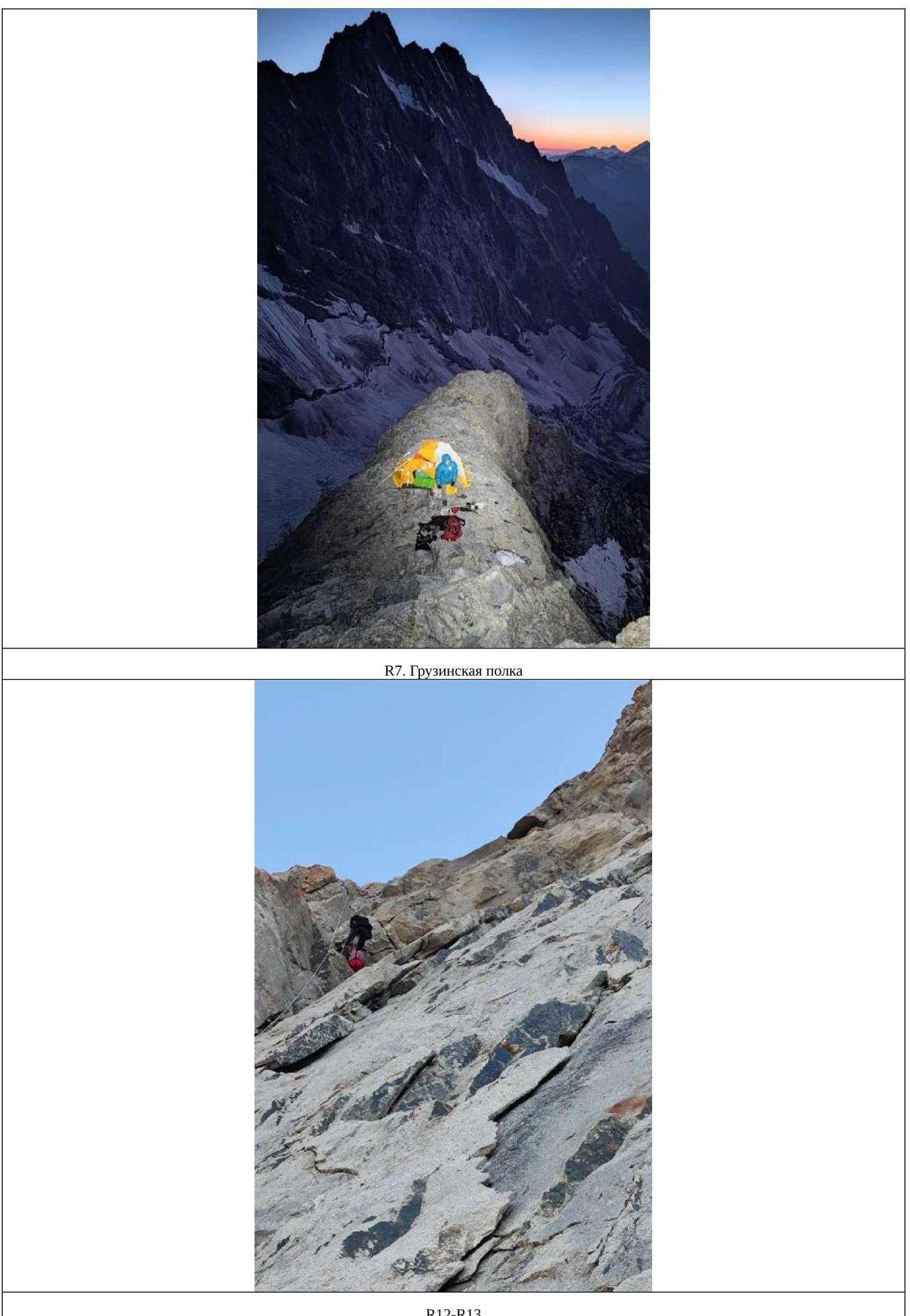
R0–R1. Via scree and simple rocks, reach the ridge. 250 m, 2, 30°. R1–R2. Turn right and move along simple rocks towards the Pillar. 300 m, 2, 30°. R2–R3. Through an internal corner via simple rocks. 200 m, 2–3, 40°. R3–R4. Via rocks of medium complexity leading to the ascent vertex. Native pitons are encountered. 50 m, 4, 60°. R4–R5. Move along simple rocks to a simple descent to a snowfield. There is a place for a bivouac. 120 m, 4, 55°. R5–R6. Then via simple rocks and slabs, approach a sheer rock section about ten meters high. 100 m, 2, 35°. R6–R7. Ascend the rock to a sharp ridge (there are anchors), transitioning to an expansion into a "Georgian shelf" (hereafter GS). There is a place for a bivouac. Not exposed to rockfall. Having ascended another 20 meters via simple rocks, there is another platform, but it is more dangerous regarding rockfall. Water is to the right of GS; depending on the season, it may not be present. 80 m, 4, 70°. R7–R8. Via simple rocks, reach the beginning of the grotto. 100 m, 2, 25°. R8–R9. Having circumvented the grotto from the right and chosen an optimal ascent route, ascend to a comfortable shelf with a memorial plaque. There are many driven pitons and remains of rappel loops on the shelf. The condition is satisfactory. 50 m, 5, 65°. R9–R10. From the plaque, rappel down about 8 meters and traverse via simple rocks to the start of the Myshlyaev Corner. 40 m, 2, 60°. R10–R11. Up the corner. There are places for reliable anchors. 50 m, 5, 70°. R11–R12. Further up the corner. 40 m, 6, 80°. R12–R13. Having overcome a small overhang, ascend slightly higher to a comfortable station. 45 m, 6, 85°. R13–R14. Via the corner to the place of divergence of the crack and mini-grotto. Move along the left side of the crack to an overhang and a sloping shelf. There is a station. There may be ice formation. 50 m, 6, 85°. R14–R15. Up a wet chimney. Steep rocks. Depending on weather conditions, it may be flooded with water or have ice formation. 50 m, 6, 90°.
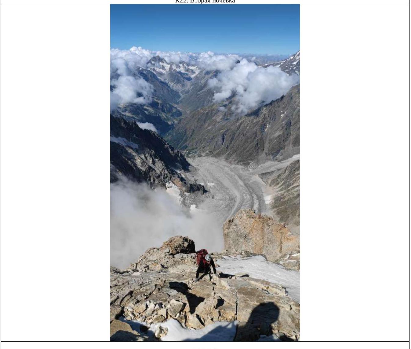
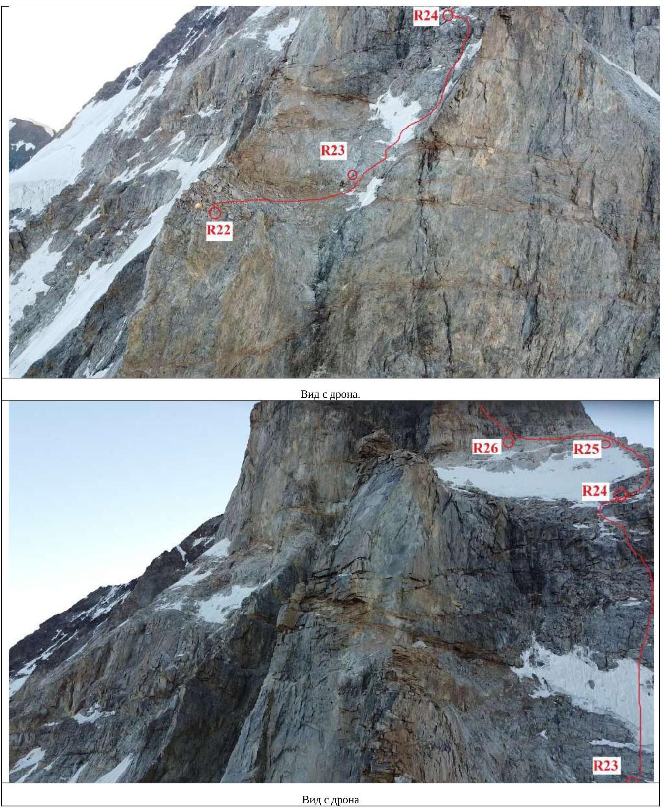
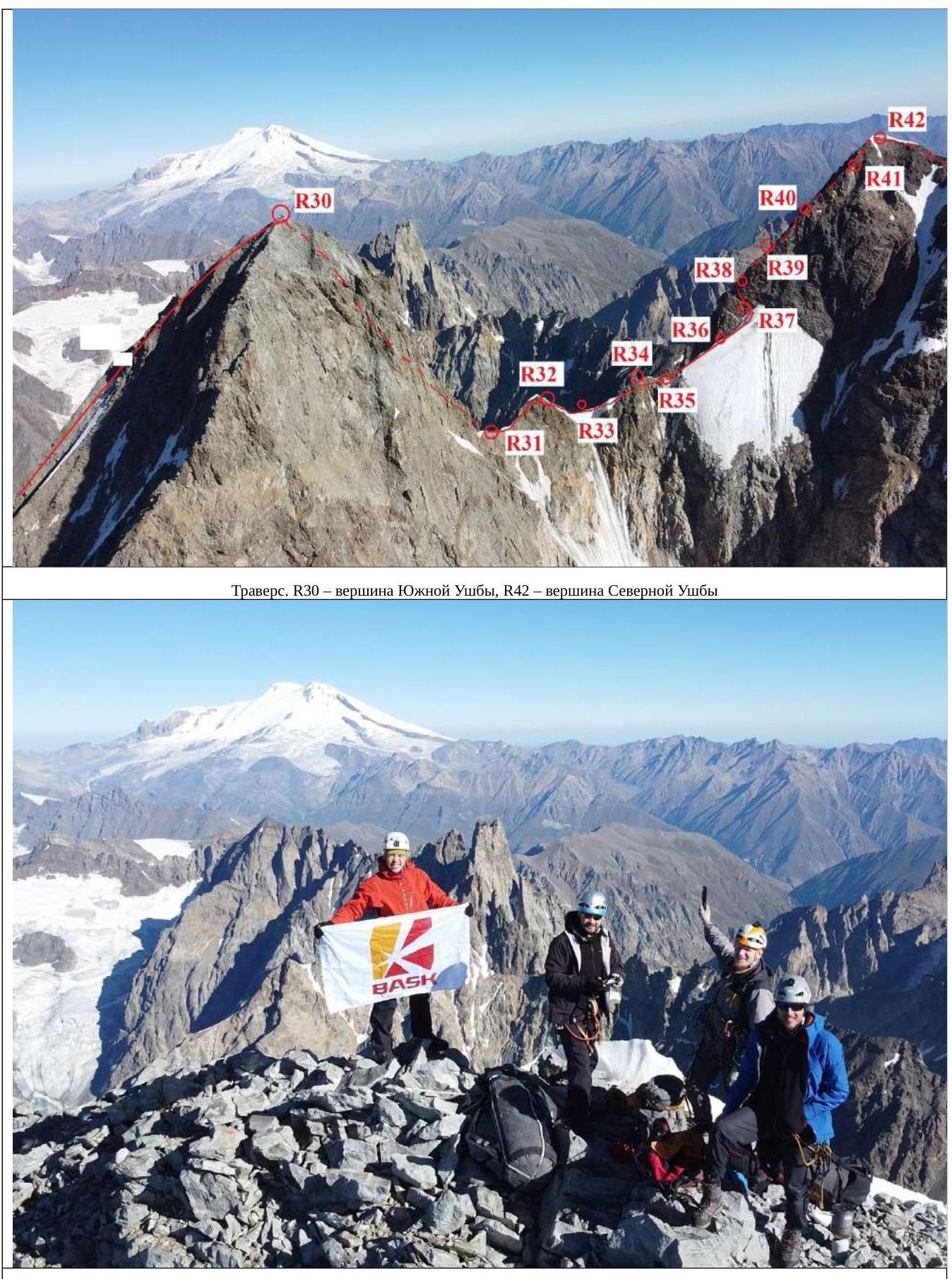
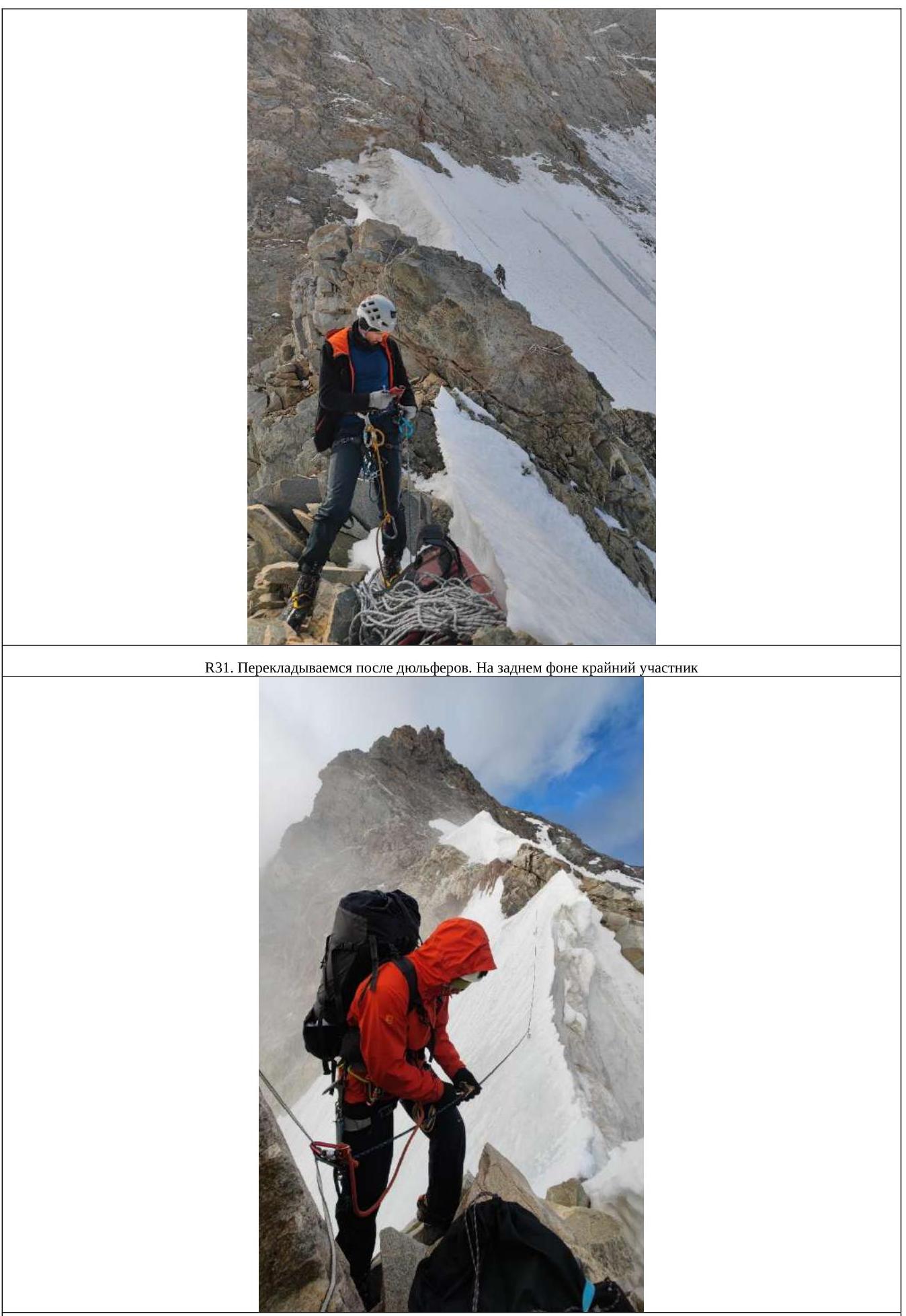
R15–R16. Through an internal corner and a wide chimney, reach flat slabs. Depending on weather conditions, it may be flooded with water or have ice formation. 45 m, 5+, 70°. R16–R17. Initially along slabs, moving slightly left. 40 m, 3, 55°. R17–R18. Via destroyed rocks, traverse right to the supposed bivouac location. Highly destroyed. Exposed to rockfall from above. 45 m, 4, 60°. R18–R19. Right and up via destroyed rocks to a shelf. There are remains of a station. 60 m, 4, 60°. R19–R20. Along the shelf and destroyed rocks, move towards a bivouac platform located under the peak of the Pillar. There is mobile phone coverage. Water from snow. 20 m, 3, 40°. R20–R21. From the platform, directly up via sheer rocks and an overhang. Native pitons are encountered. 55 m, 6, 90°. R21–R22. Via complex rocks to the peak of the Pillar. There is a place for a bivouac. 55 m, 6+, 80°. R22–R23. Along a sharp ridge, reach an osypnaya shelf. Traverse right to the start of a rock rib leading to the Red Corner. Depending on weather conditions, there may be snow present. 200 m, 1–4, 30°. R23–R24. Via destroyed and icy rocks of medium complexity, move along the rock rib until it flattens out. 150 m, 3–4, 55°. R24–R25. Via inclined slabs, reach and approach the base of the bastion. 200 m, 3, 40°. R25–R26. Traverse left to the base of the internal corner. 100 m, 4. R26–R27. Up the corner. 50 m, 6, 85°. R27–R28. Up the corner, circumventing an overhang from the left, move via an internal steep corner to a control tour. Many old pitons. Possibly, the rocks will be in ice formation and flooded with water. 50 m (5 m), 6+ (A2), 90°. R28–R29. Via destroyed rocks of the couloir to a shelf on the pre-peak ridge. Destroyed, possibly exposed to rockfall, unreliable place. On the pre-peak ridge, there are places for a bivouac. 55 m, 4, 70°. R29–R30. Via simple, destroyed rocks to the peak. 400 m, 2, 30°. R30–R31. Descent to the saddle between South Ushba and North Ushba. 5 rappels of 50–60 meters. 4 rappels via rocky terrain, 1 rappel in the lower part via snow-ice terrain. Slopes are loose, местами камнеопасные with an incline of 70–80°. 2nd rappel 10 meters without anchor points. 300 m.
R31–R32. Movement along the saddle upwards to a gendarme in a team. Crampons. Anchors on rocks. 50 m. 3. R32–R33. Descent to the icy part of the saddle, station on ice screws. 50 m. R33–R34. Movement traversing along inclined ice towards rocks 40 m, anchors on ice screws, then via rocks upwards and left 20 m, 4, 70°. R34–R35. Movement via rocks towards a snowfield, 40 m. 3. R35–R36. Rappel down to inclined ice, then reach a snowfield and further along it 50 m. R36–R37. Via a snowfield to an internal corner, station on rocks. To the right and above, 30 meters away, there are places for an overnight stay for 2–3 people. 40 m. R37–R38. From the station, up via simple rocks 15 meters, then move left and reach the rib of the peak tower of North Ushba. 50 m, 3, 70°. R38–R39. Further up the rib. 50 m, 4, 70°. R39–R40. Continue ascent via the rib. 50 m, 4, 70°. R40–R41. Ascent up the rib, keeping to the right part, at the end of the rope there is a place for a small tent. It is better to set up while on anchors. 50 m, 3, 70°.
R41–R42. Ascent to the peak via simple rocks, crampons in the upper part. On the peak, there are snowy drifts. 50 m, 3, 70°. R42–R43. Movement along the snow-ice ridge in a team, anchors on ice screws and snow anchors. Move until reaching a shovel-shaped slope. 300 m.
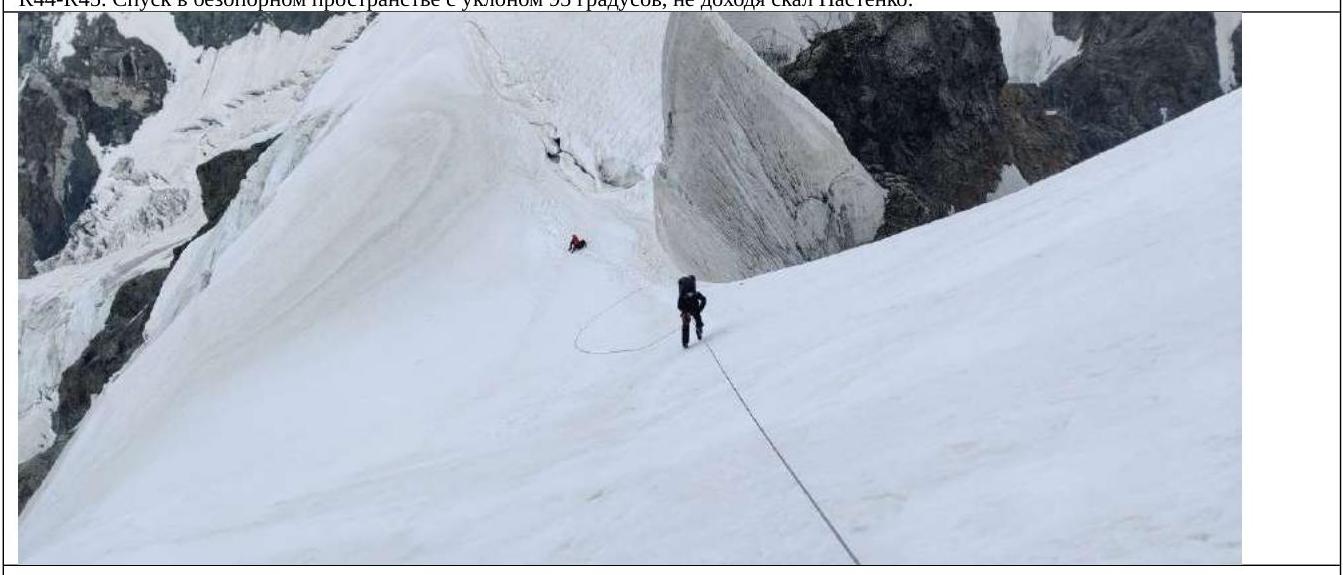
R43–R44. Descent along the ice slope (via the Snowy Board) (depending on the season and weather, it may be snowy). 5 rappels of 60 m, 45° to the rocks of Nastenko.
R44–R45. Descent from Nastenko's rocks to the flattening, overcome the bergschrund. 3 rappels of 60 m, 45°. R45–R46. Passage of Ushba Cushion in a team 500 m. R46–R47. Descent in a team from Ushba Cushion, first down, then after 50 meters sharply to the right 150–200 m, avoiding ice crevasses. 250 m.
R47–R48. Movement along the glacier in a team, on the pass there are places for tents, from here they usually start the ascent to North Ushba via the 4A difficulty level route. 500 m.
R48–R49. Descent along the rugged glacier in a team, crevasses, rockfall is possible from Shkhara. After 2 km, the glacier gives way to an osypnoy slope, along which another 700 m to a snowfield, at the end of the osypnykh slopes there are ram's foreheads.
R49–R50. Cross to the snowfield and descend down to the flattening of the glacier. 200 m. Then to BC, through the moraine and glacier, reach the trekking trail, through the border outpost to Mazeri village.
2.3. Characteristics of the Team's Actions
The basis of the route is the ascent to South Ushba via the left part of the Southwest wall (L. Myshlyaev, 1960 ) 4710 m, after which the route goes to a traverse via the saddle to North Ushba 4690 m with a subsequent descent via the classic route 4A difficulty level. The choice of the route was based on a safe and accident-free passage due to the stability of the terrain; nevertheless, it cannot be called completely safe. Also, due to the not small team size, the emphasis was placed on the interesting and adventurous nature of the event, which served as a logical continuation of the route with a further ascent to North Ushba peak. The characteristics of the terrain and overnight stays during the ascent via Myshlyaev's route to South Ushba were known to us due to the presence of reports; the further traverse of the peaks was a small intrigue, which fueled the climbers' interest.
The ease and style of the ascent, the absence of IT sections, and the friendly atmosphere in the team made the ascent pleasant and memorable.
Four people took with them:
- 2 sleeping bags
- 3 sleeping mats
Poles and unnecessary items were left in the base camp. The supply of food and gas allowed us to stay for an additional two days on the mountain in case of worsening weather, which we expected during the ascent. From old stocks, a snow anchor was taken, which pleasantly surprised us during the traverse and descent from the route, and the charge of optimism was enough to continue the traverse elsewhere.
In our opinion, this traverse of South and North Ushba peaks is the most logistically convenient due to the start and finish at the same point, allowing for the establishment of a base camp and leaving some things there.
2.3.1. August 27, 2023
On August 27, 2023, with heroic efforts, we carried our bags to the base camp in 3 hours. Realizing that we needed to lighten our load, the commission for reducing weight decided to exclude:
- personal hygiene items,
- spare clothing,
- one rope,
- several protection elements,
- a sleeping bag.
After a control weigh-in of the drone (just over 2 kg), another sleeping bag was excluded as non-essential equipment for the August–September period. The drone, in turn, had immunity and was taken along. Using it, without leaving the base camp, we conducted a reconnaissance of the approach to the start of the route. Unnecessary things were hidden, and the rest were packed for a quick start.
2.3.2. August 28
At 05:17, we set out towards the route, passed the moraine on the left side, then climbed onto the glacier and, circumventing crevasses, approached the start of the route. Having removed crampons, we began movement. The rocks were not complex; initially, we managed on personal equipment, later we used ropes.
At 16:00, we were on the Georgian shelf and processed two sections on the "Pillar" for the next day. There was no water on the shelf, so we had to:
- descend to the snowfield,
- collect a bag of snow.
The shelf had to be expanded due to the considerable size of the tent.
2.3.3. August 29
We started on the route at 07:00, passed the first two processed sections, and worked further at a steady pace until we reached the flattening. Closer to the flattening, sections of rocks with ice and icicles began to appear.
The sun at this time of year illuminates this part of the wall approximately from 14:00.
We reached the flattening, dragging bags with bivouac equipment on ourselves. We decided not to stop at the lower overnight stays and continued further to the upper ones.
At 19:30, we stopped for the night. Nearby, there is a snowfield where snow and ice can be collected. The platform had to be expanded to fit the not-so-small tent, which was not very suitable for this type of ascent.
2.3.4. August 30, 2023
We started at 08:00, passed the icy part of the route using ice screws, and reached the pre-peak tower. Then we tried to find the Samara team variant, which we read about in the description – but couldn't find it. Clouds rolled in, and we decided to go via the red wall, the internal corner of which turned into a huge chimney, or rather, a canyon 4–5 meters wide.
The place was dangerous:
- We set up a station further away.
- While the first and second participants overcame this section, we installed bags as barriers against rocks – and it was very necessary.
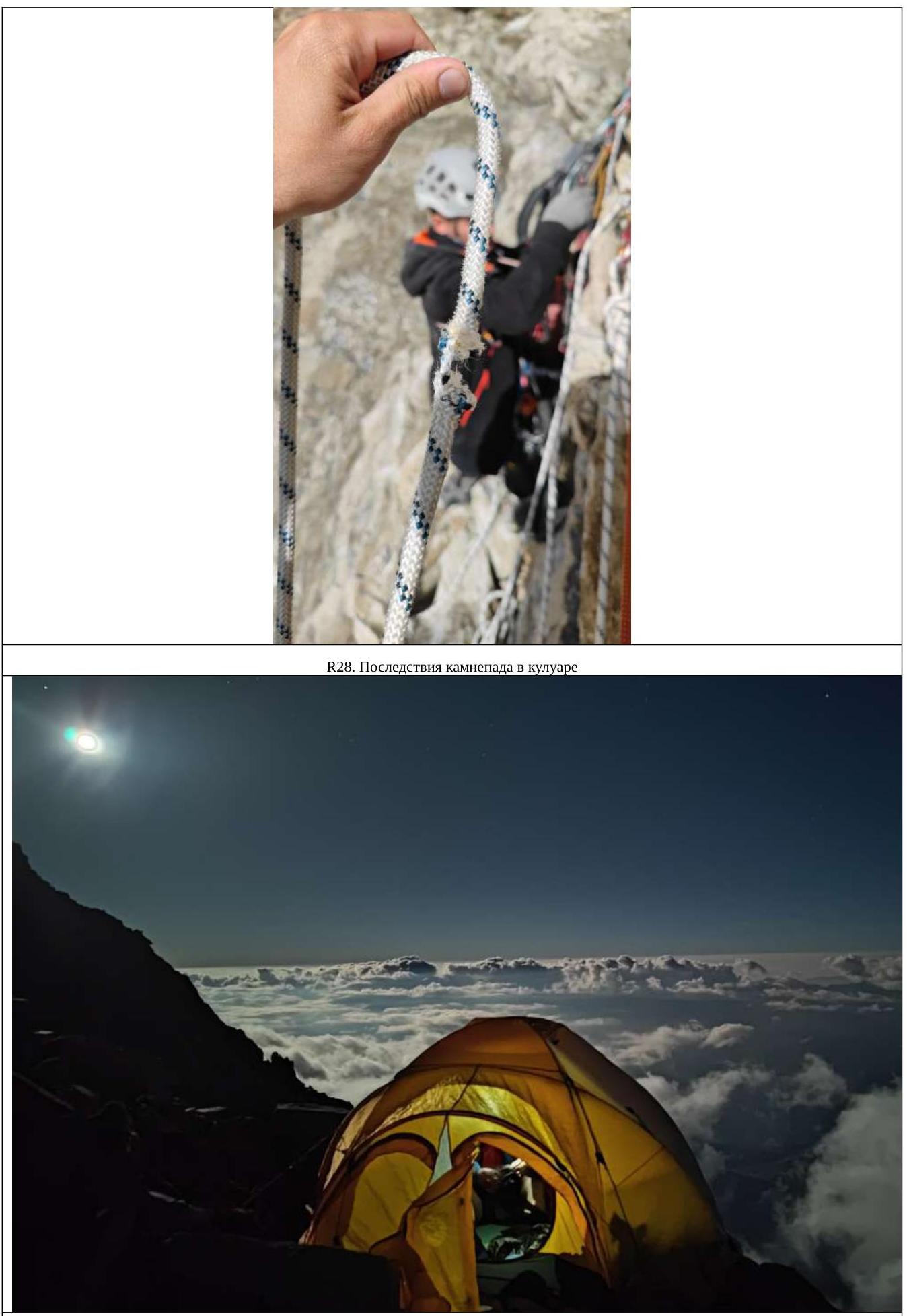
- The rock is very loose, and rocks were breaking off.
- As a result of the ascent, on the last meter near the station, a huge block slipped from under the second participant, collecting everything with it.
- About 2 tons of rocks were dislodged.
- A bag was torn.
- Two of the three ropes were damaged (fortunately, the third was in the bag).
The participants were not injured due to the competent organization of the station and being on it, but it was unpleasant. We passed the section with the remaining intact rope, tied the two damaged ones together – one was damaged in one place, the other in two. We ascended higher along a pedestrian slope and set up a tent, having previously prepared a platform for it in about an hour.
2.3.5. August 31, 2023
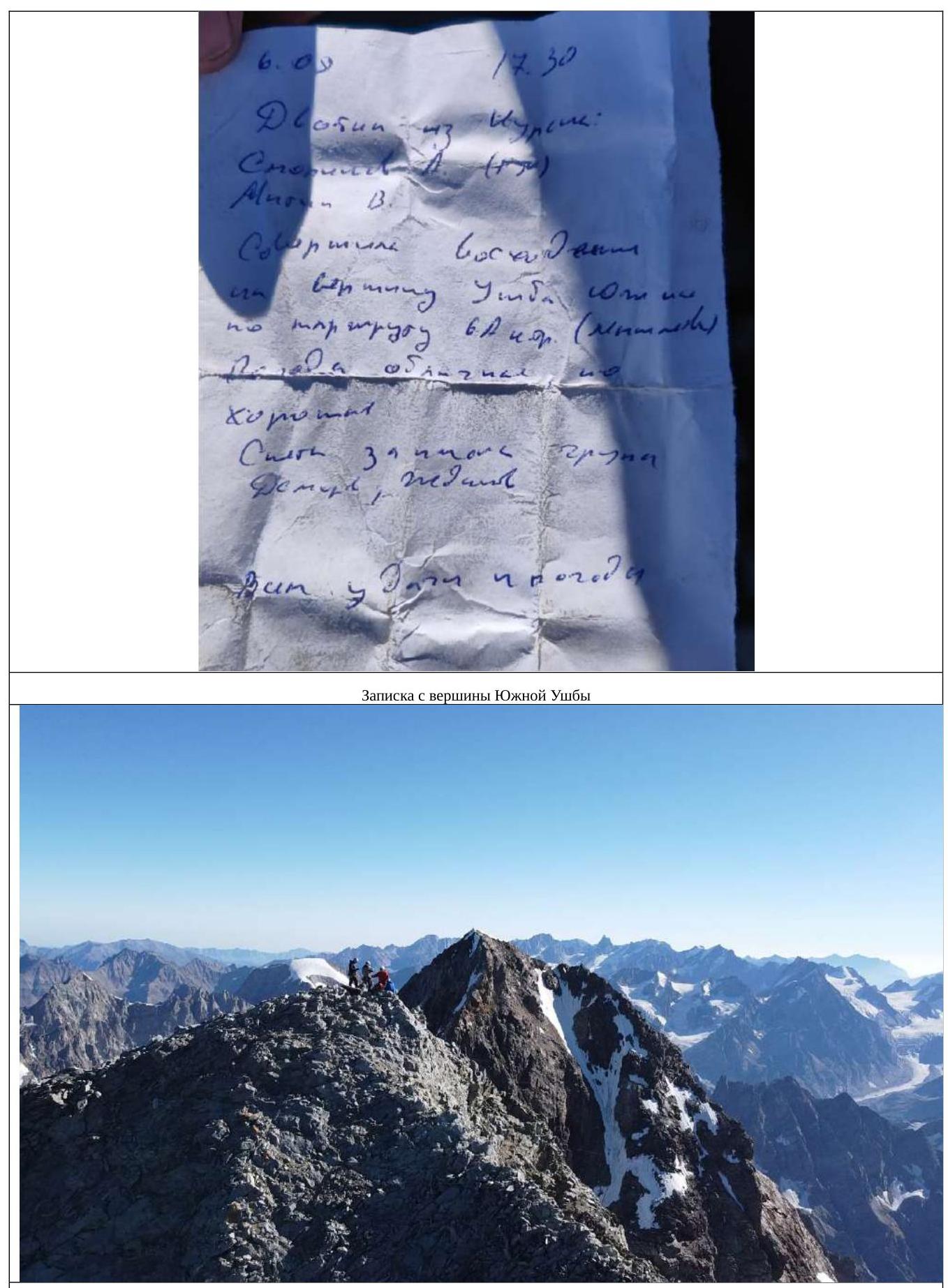
We set out at 06:50 – it was easy and pleasant. In the upper part, we used ropes for anchors. We reached the peak at 07:50. We found a note from the Kursk team, Smolinov – Mitin, who had ascended via Myshlyaev's route, 6A difficulty level. We left the note as we had nothing to write with. Having had a snack and taken photos, we began our descent to the saddle. The rappels were complicated by one intact rope; we had to constantly switch through knots on damaged sections of the ropes, in unsupported space, and with a bag – not the most pleasant experience.
The descent included:
- 4 rappels via rocky, местами osypnoy terrain,
- one diagonal rappel via snow-ice terrain to the saddle.
Movement along the saddle was initially via rocks, then along inclined ice – descending, ice screws were needed. It was not possible to move along the top with a parade step – due to cornices. Then again, a rocky section and an ascent via a snowfield to the pre-peak tower. Further climbing was not particularly difficult. After 5 ropes from the snowfield, we found a place suitable for half a tent. As a result of construction and installation work with a bias towards stone masonry, we increased the tent's coverage area to 2/3. We expanded the shelf while on anchors, with abysses on the sides. We slept in the tent in harnesses, having strapped ourselves in and tucked our legs, as part of it was hanging in the air.
2.3.6. September 1
At 07:40, we set out on the route and reached the peak at 08:05. We didn't find a note or a tour; we didn't set one up either – we had nothing to write with. We took photos, had tea, admired the views, and set out further at 09:20.
We traversed in a team simultaneously, with anchors on ice screws and a snow anchor. We reached the descent point. Initially, we planned to descend via anchors with the last person climbing down. The slope was pure ice, so we abandoned this idea and descended with a rope retrieval through an Abalakov loop. The event was complicated by damaged sections of the ropes and knots tied on them.
We descended:
- 5 rappels, not reaching Nastenko's rocks,
- then straightened the section and passed through an overhanging ice slab,
- another 3 rappels to the flattening and Ushba Cushion.
After that, on foot in a team, we traversed Ushba Cushion, avoiding crevasses, and admired the Ushba Mirror, reaching the pass and overnight stays. We didn't descend further; we found left-behind sublimates and decided to enjoy the remaining day in the mountains.
On the pass, Russian cellular coverage is available; the weather promised to be good, and the road home, a sauna, and Shafutdinov Day awaited us. In the evening, avalanches descended from North Ushba.
2.3.7. September 2
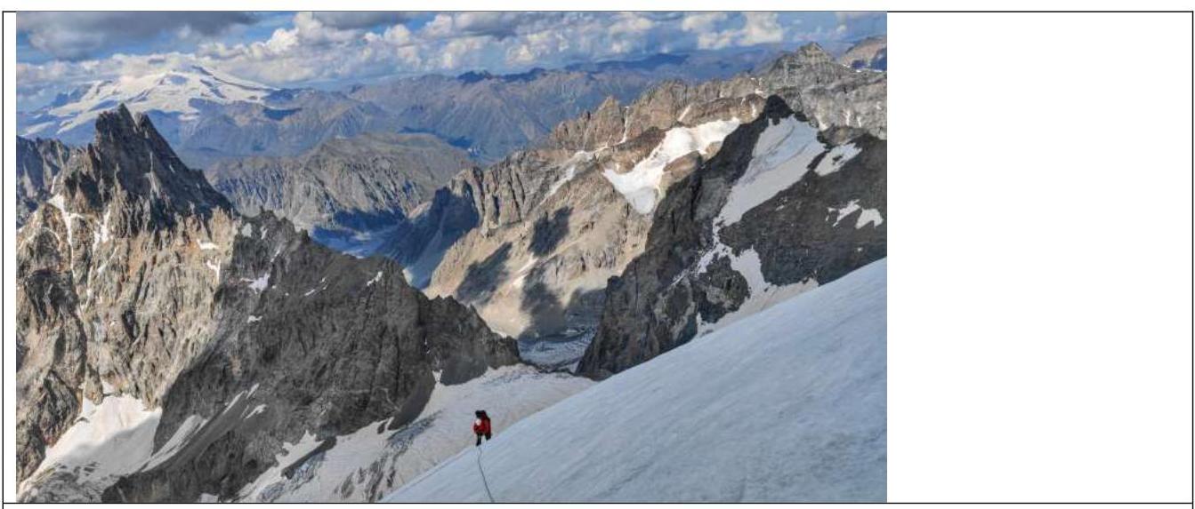
We set out at 08:00. We traversed the glacier in a team, searching for paths, crossing snow bridges, and jumping over crevasses. We kept between the middle and the right part of the glacier, adjacent to the Shkhara massif, but still closer to Shkhara, although we didn't want to due to possible rockfall.
We reached the ram's foreheads and transitioned from them to a snowfield, along which we descended down to the glacier. On the glacier, elements of a destroyed bivouac are often encountered:
- torn sleeping bags and down jackets,
- broken helmets,
- and other equipment.
Having made a detour through the center of the glacier, we descended down and enjoyed sunbathing with a dip in the pools formed on the glacier. We descended to the base camp, retrieved previously hidden things, ate with appetite, rested, took a nap, and decided to descend further. At 14:00, we began our descent to Hikers Inn (cafe, sauna, guest house), where we stayed for the night.
2.4. Photos from the Route
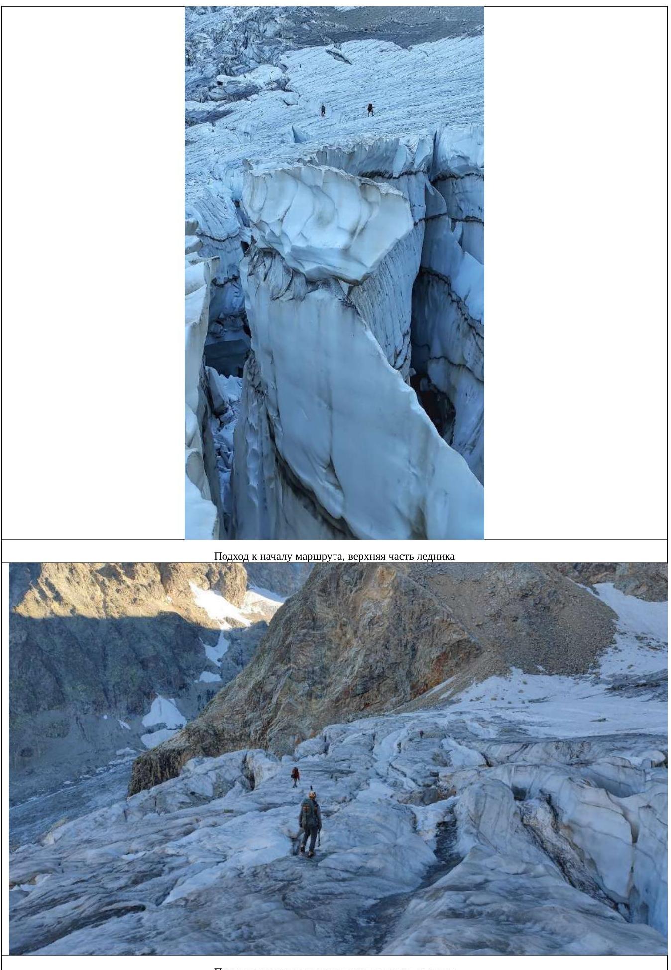
Approach to the start of the route, upper part of the glacier.
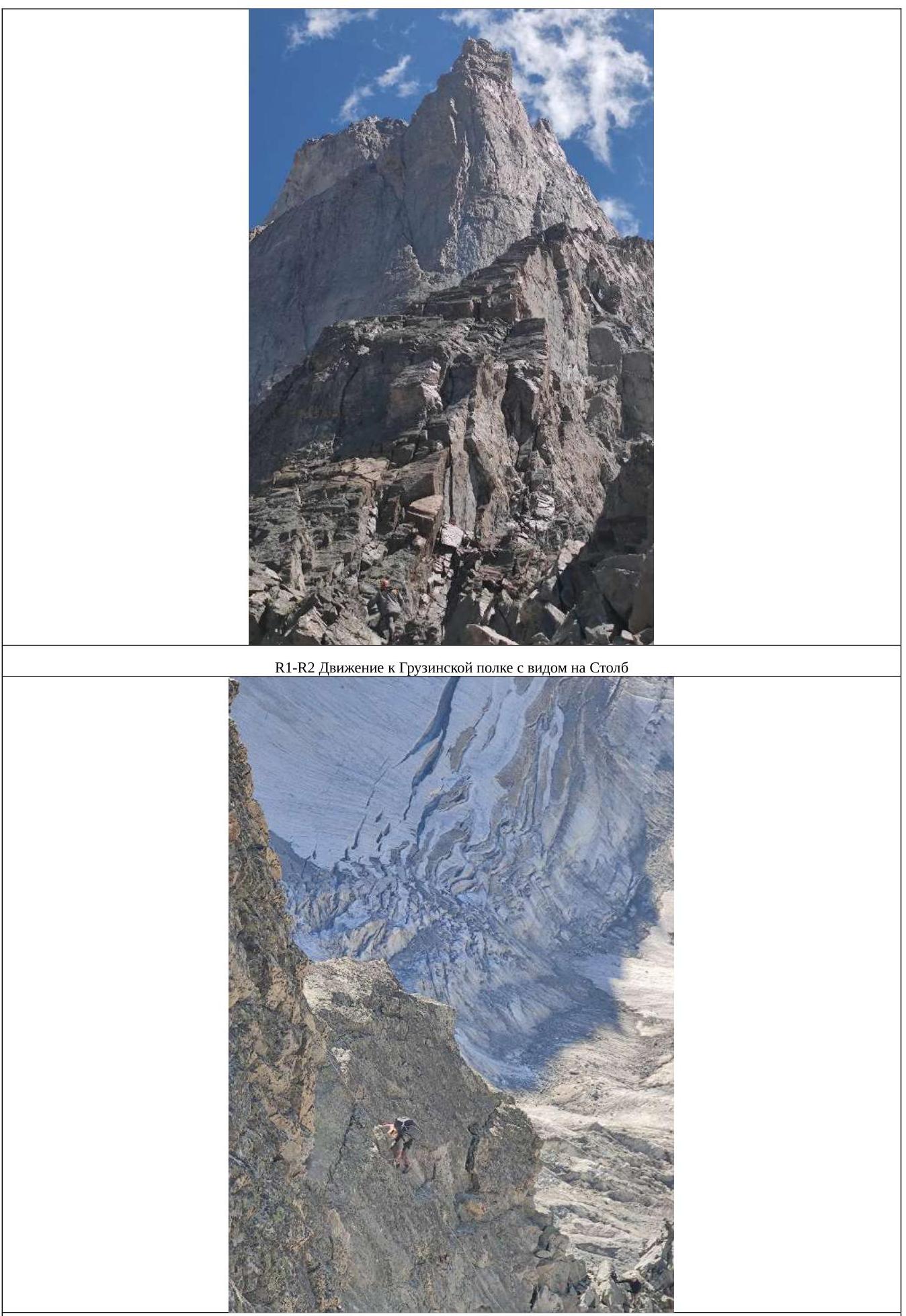
R5–R6.

Tent on R7.
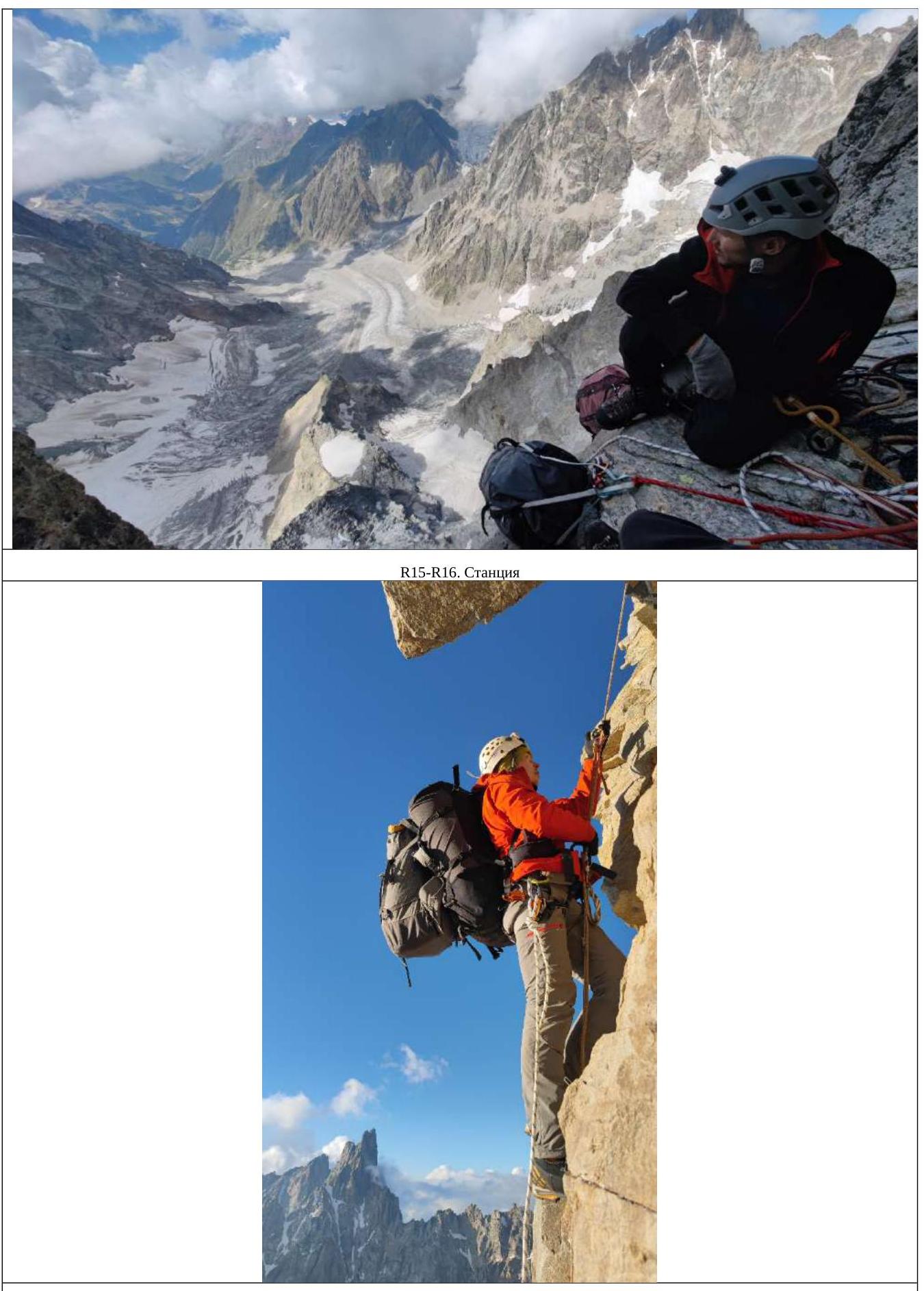
R12–R13.
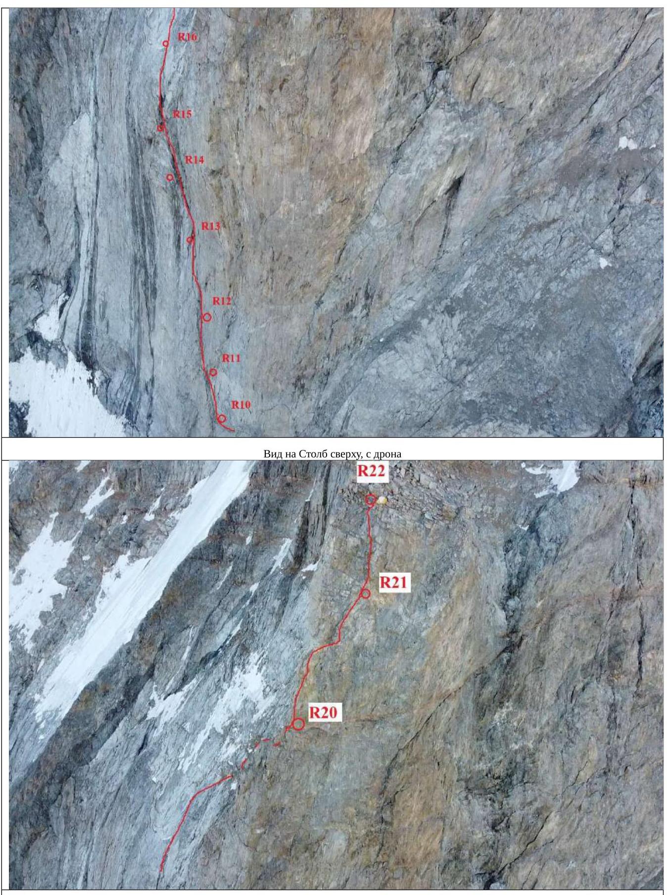
View of the upper part of the Pillar from the drone. On R22, a tent is visible.
R20–R21. From the platform upwards.
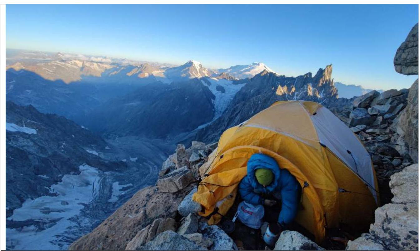
R22. Second overnight stay.
View from the drone.
Overnight stay on R30.
Peak of South Ushba 4710 m.
Team on the peak of South Ushba 4710 m. from left to right:
- Prostakishin Dmitriy
- Zherdev Kirill
- Komarov Pavel
- Sayfullin Il'dar
R35–R36. Reaching the snowfield.
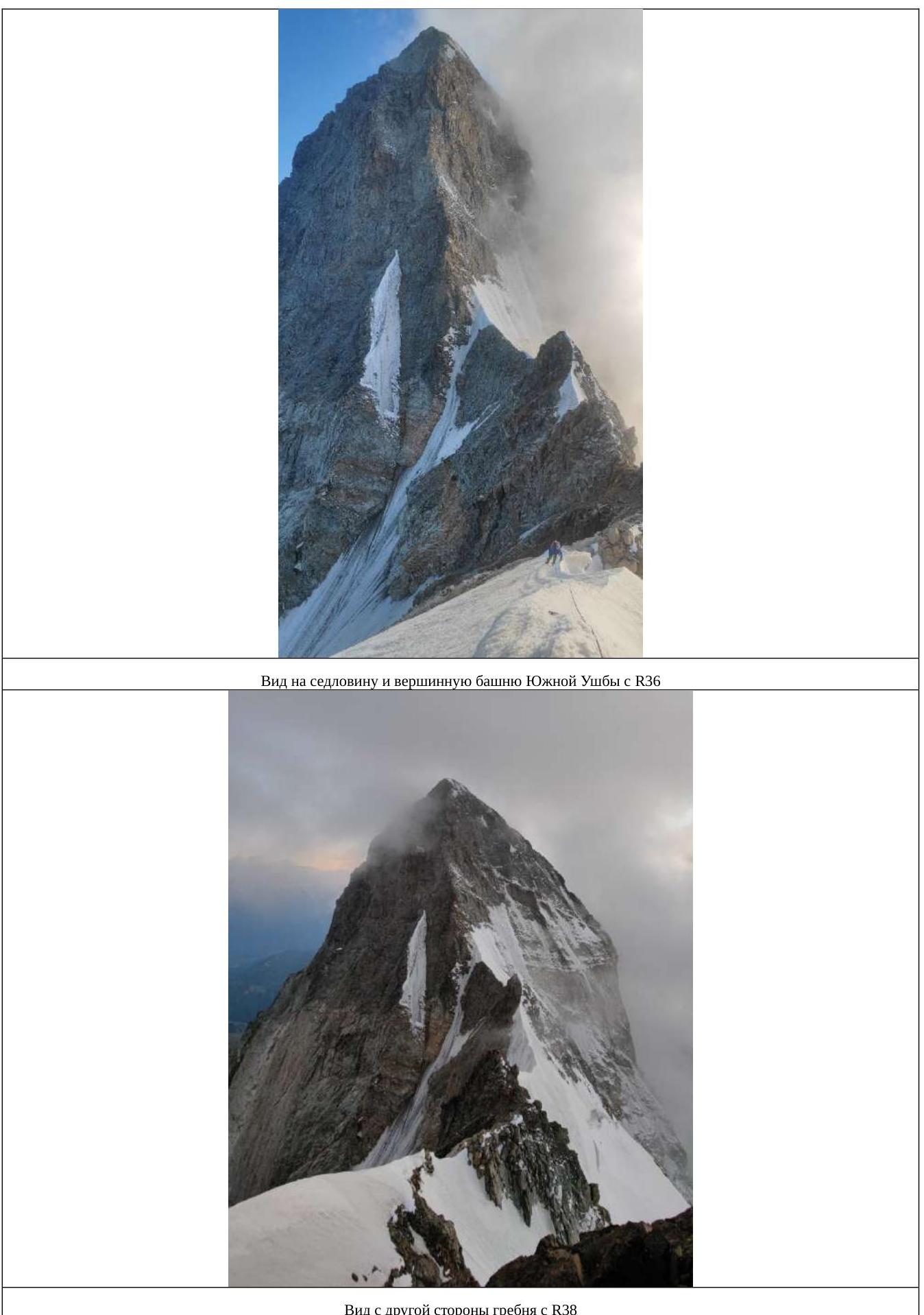
View from the other side of the ridge with R38.
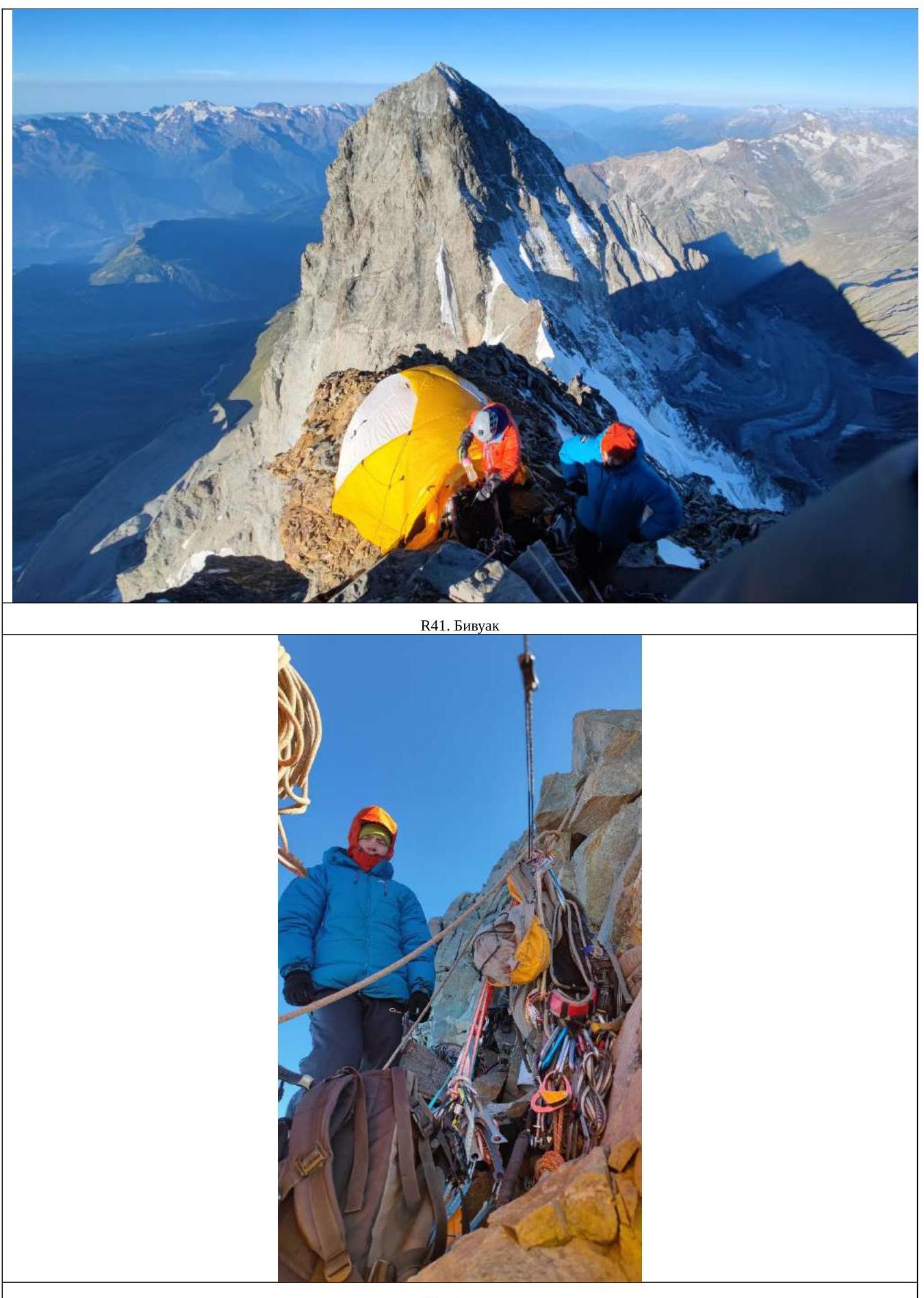
R41. Station.
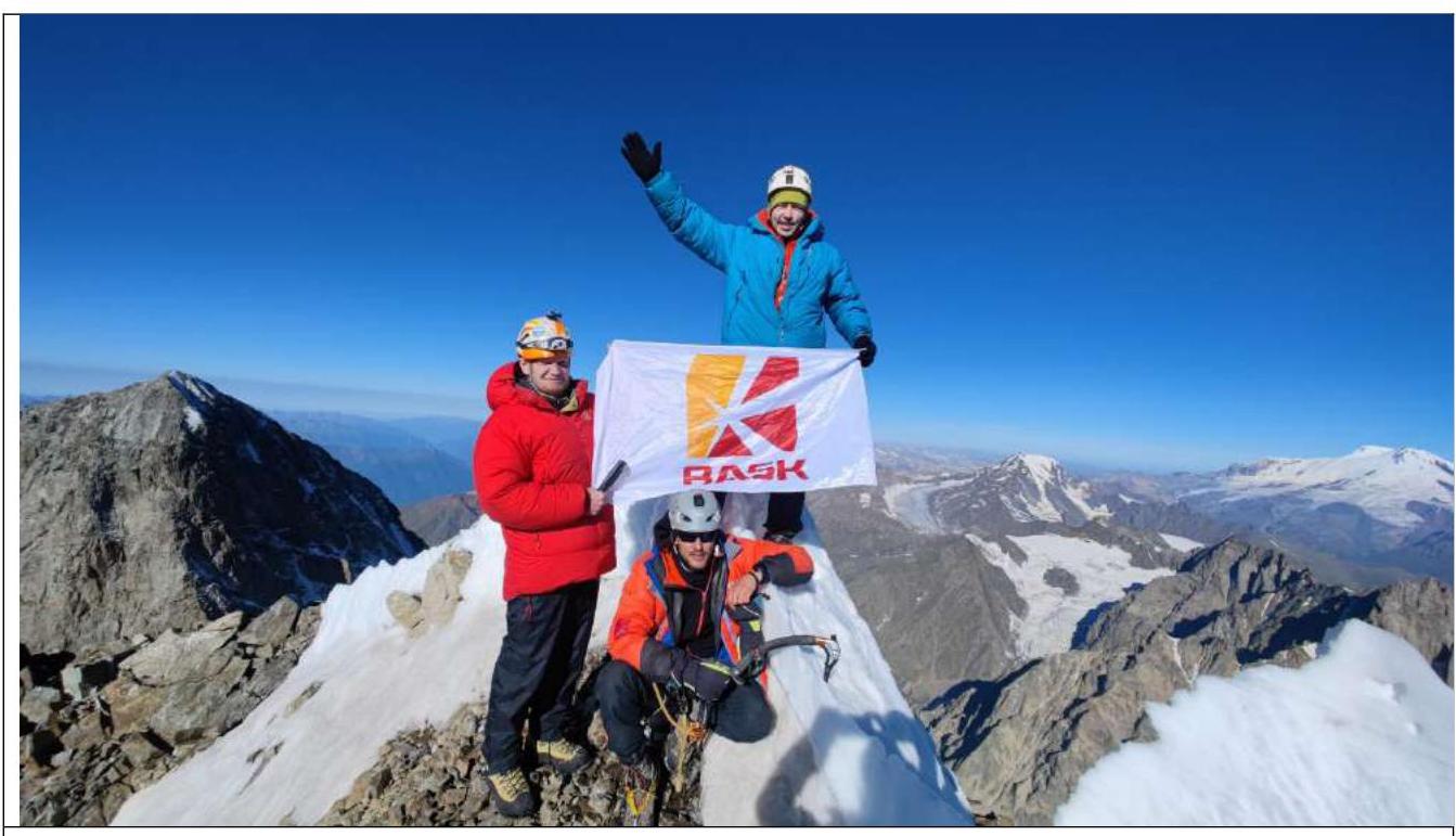
Peak of North Ushba 4690 m. from left to right:
- Komarov Pavel
- Sayfullin Il'dar (sitting)
- Prostakishin Dmitriy
- Zherdev Kirill

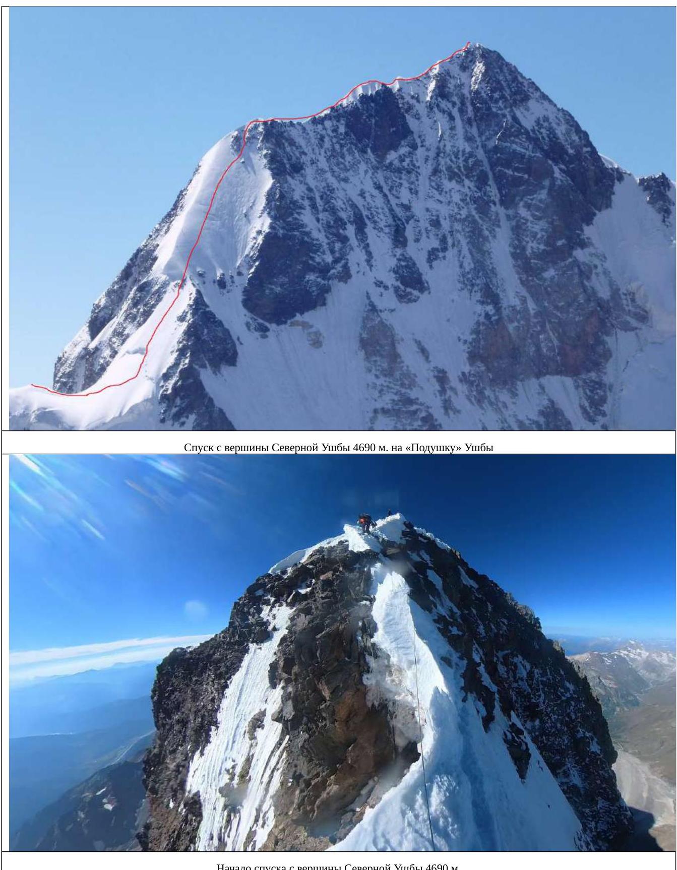
Start of descent from the peak of North Ushba 4690 m.
Descent along the ice slope (via the Snowy Board) (depending on the season and weather, it may be snowy). 5 rappels of 60 meters.
R44–R45. Descent in unsupported space with an incline of 95°, not reaching Nastenko's rocks.
Descent to "Ushba Cushion".
![img-27.jpeg]({"width":1343,"height":1609,"format":"Jpeg","uri":"https://summitx.info/media/1/GA4Xy1UQPmQ3i7qme↗