USSR ALPINISM CHAMPIONSHIP 1981. TECHNICAL CLIMB CLASS
Central Caucasus 196a
Report
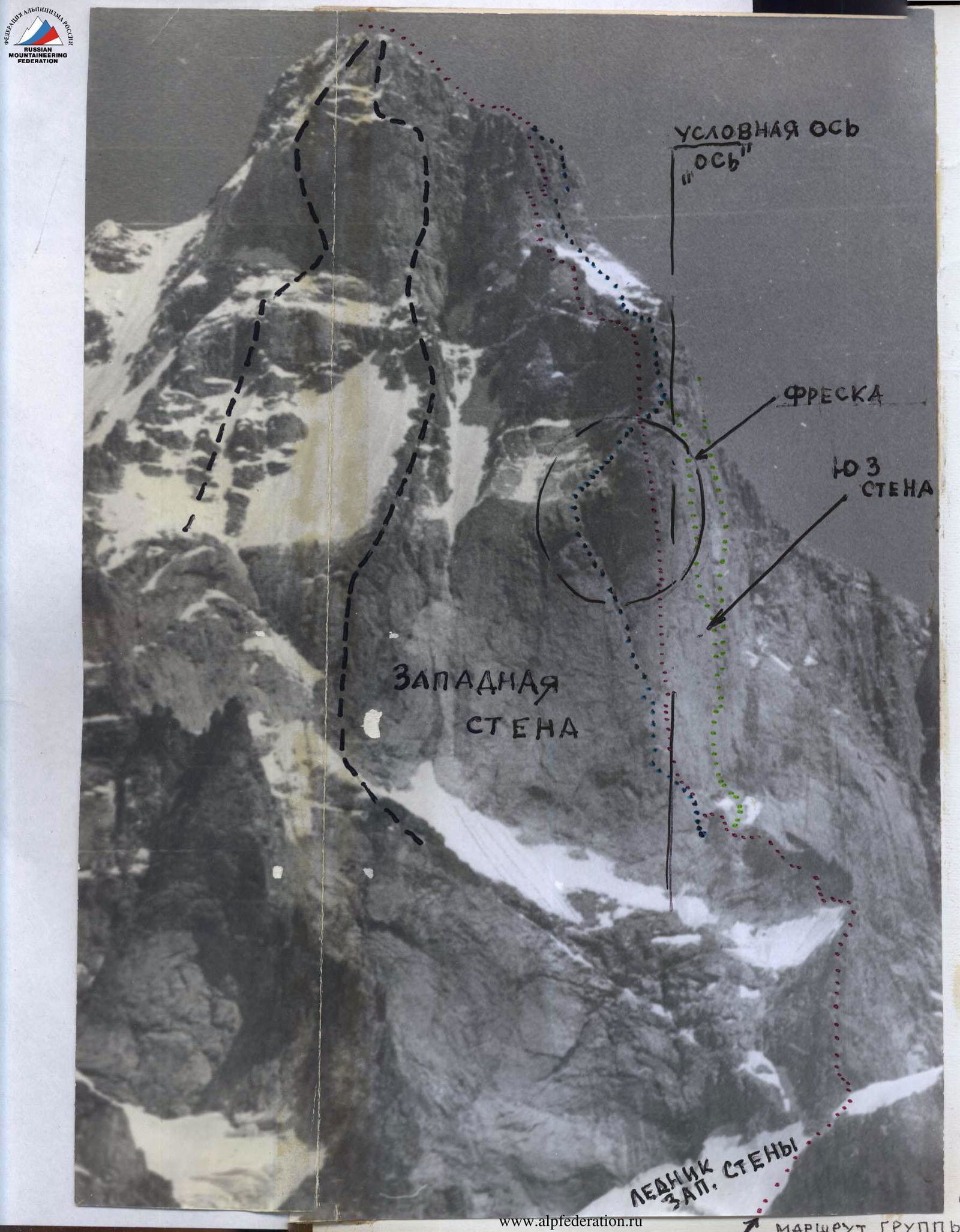
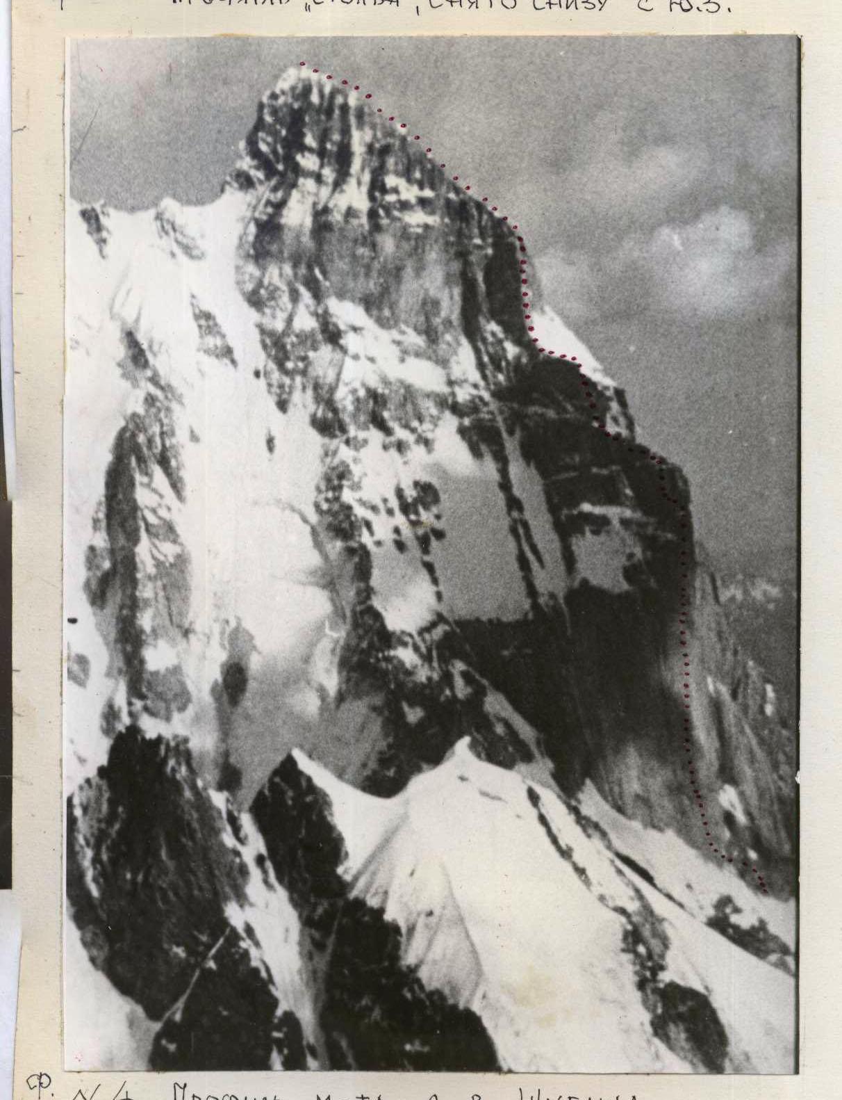
On the ascent of the Sports Committee team of the Ministry of Defense of the USSR to the SOUTHERN USHBA peak via the edge of the Western wall through the "pillar".
Brief overview of the ascent object and route
Many routes have been laid out to the peaks of the Ushba, about twenty of which have received prizes at the USSR Championships. Two 6th category routes pass along the bastions of the Western wall of the Southern peak. At the junction of the Western and South-Western walls of the second rock belt, a sheer 700-meter granite "pillar" rises. To the left, the "pillar" is bypassed by a giant internal angle of the Western wall, along which Myshlyaev—Kosmahev laid out a fine route. To the right, along the South-Western wall, a route by V. Monogarov's group goes upwards to the right, also marked with gold medals at the USSR Championship. The routes are symmetrically positioned relative to the vertical axis of the "pillar". (Along the axis, a large crevice - a chimney - runs from the top). The upper 2/3 of the "pillar" between the internal angle of Myshlyaev on the left and the visual mid-axis overhang with a convex relief "fresco". This is the protrusion of a huge monolithic slab (400–450 m long), intersected by two transverse tiers of cornices. Along the right edge of this slab, 20–30 m from the mid-axis, a route was laid out in 1981. To the foot of the "pillar", the route coincides with the route of L. Myshlyaev and V. Monogarov (300 m of the ridge). Further, 560 new meters were passed along the sheer wall. On the rocks above the "pillar", the route coincides with L. Myshlyaev's route. Further, the route goes to the bastion "knife" with a variant to the left of L. Myshlyaev's route. The climbers sought to pass the route along the edge separating the Western and South-Western walls of the massif. The ridge and "pillar" are composed of granites; on the 3rd belt ("knife"), block marbles are found. The rocks are monolithic with Western and North-Western exposure and more destroyed on the South-Western turns of the wall. During the passage, a minimum (3 pcs.) of piton hooks were used, and many anchor points were used for insurance (220 times). On the 560-meter sheer "pillar", about 130–140 I.T.O. were created for work on ladders and platforms. The objectives on the "fresco" are deep and smooth inside. The "holding" anchor points are extricable. There are no bivouac sites on the "pillar" wall, nor water. All this was taken into account when choosing a passage tactic with two days of processing the "pillar" from bivouac No. 1. The ascent took place "in the eyes" of the Lithuanian gathering and the team of the instructors' school under the leadership of A. Andreev; 2 judges of the XXXII USSR Championship came to the ascent area one after another.
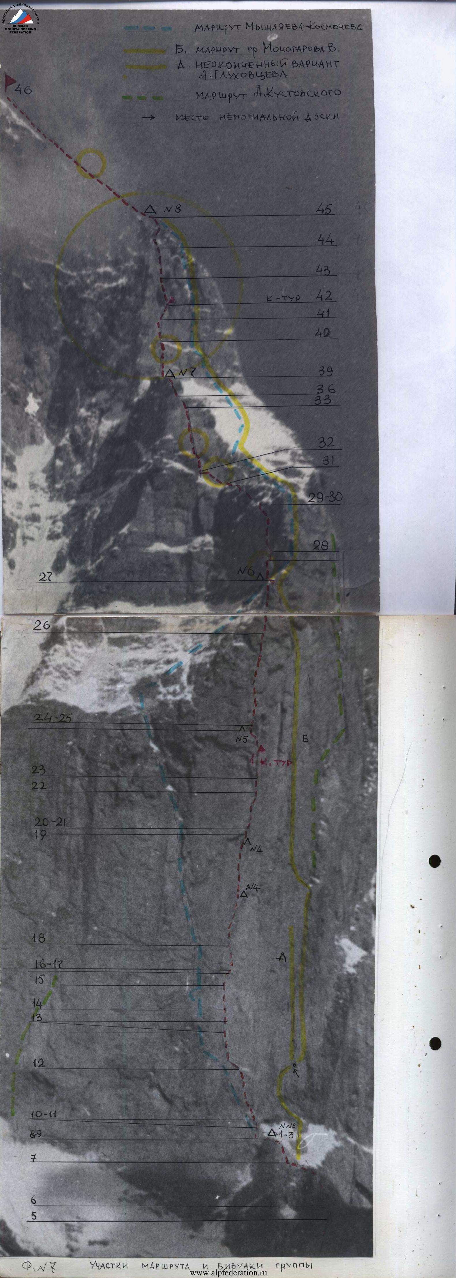
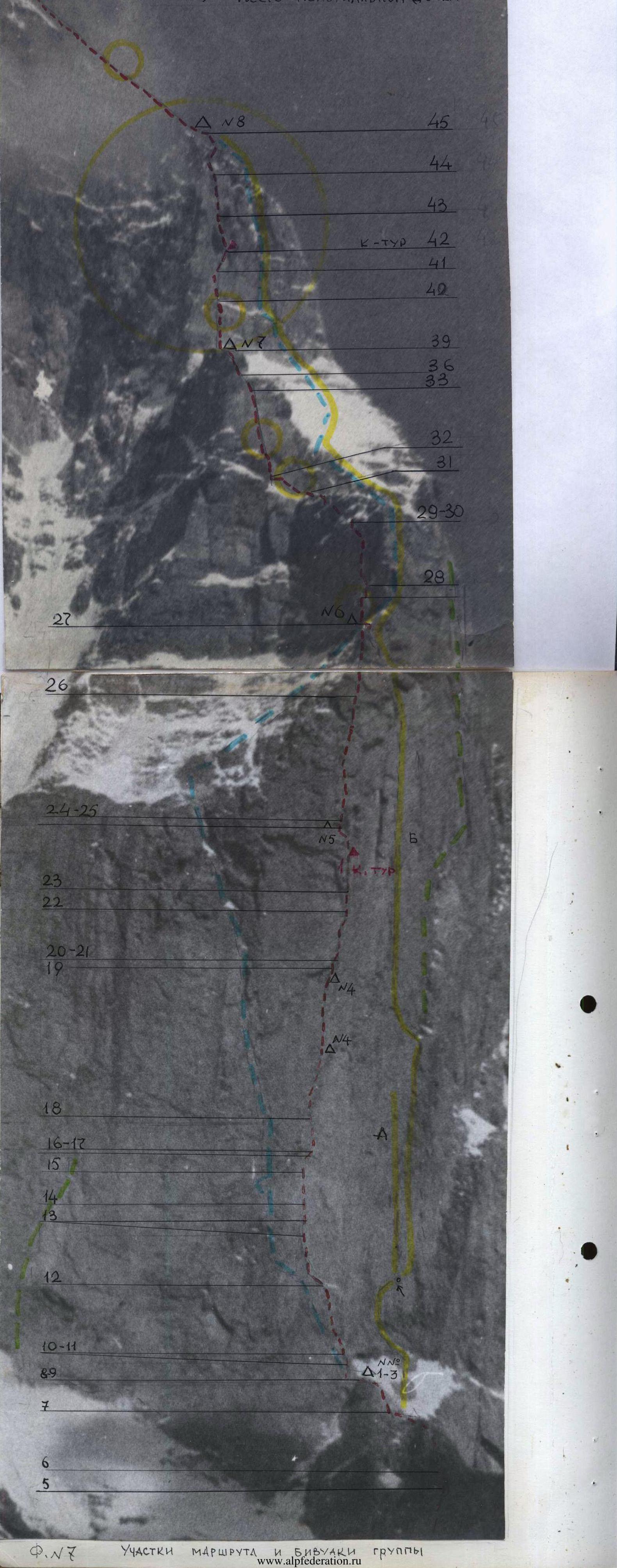
Map of the Ushba peak area
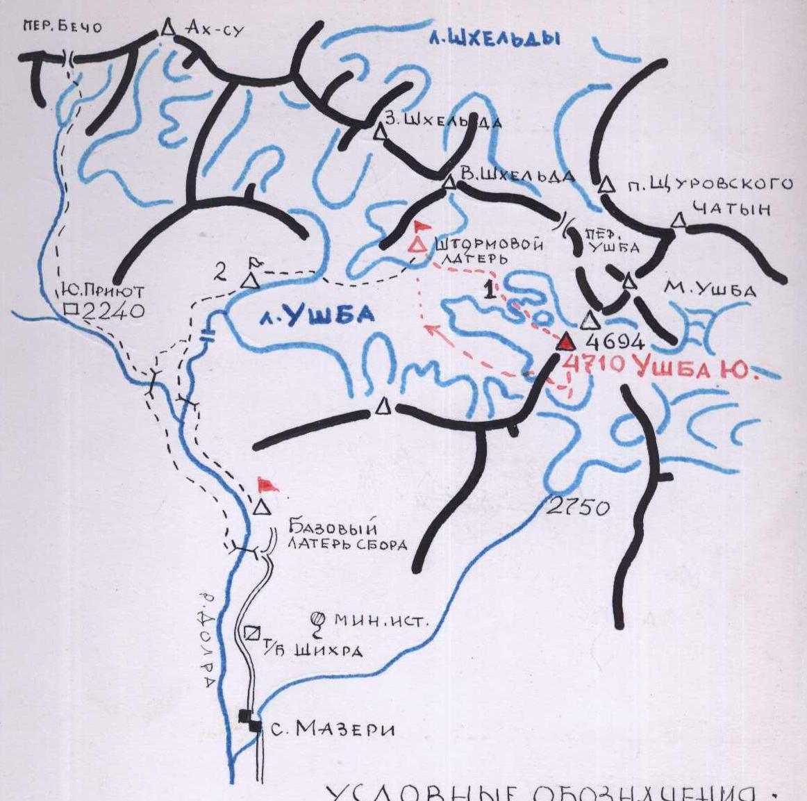
Legend:
- BASE CAMP, "M. Khertsani" GLADE
- LITHUANIAN GATHERING CAMP
- ASSAULT CAMP AND OBSERVERS' CAMP
- WESTERN WALL GLACIER OF SOUTHERN USHBA
- TRAILS AND APPROACHES
- Group's path to the peak and descent
Routes on the W. and W. wall:
- m-t Zhivlyuk
- m-t Artsishevsky Yu. and variant Slesov I.
- m-t Grigorenko—Prigoda
- variant G. Shalaev 73
- H/ -1- Likhenitsky
- m-t L. Myshlyaev—Kosmahev
Routes on the S.W. wall:
- uncompleted variant A. Glukhovtsev
- and 10 m-ty V. Monogarov
- m-t A. Kustovsky
 Conditional axis
The climbers' routes are given according to the data of the Elbrus region KSP and according to the report of G. Shalaev (1973...). Detailed sections photos No. 6, 7, 9
Preparation for the ascent
The team of the Sports Committee of the Ministry of Defense of the USSR in the technical class consists of athletes from the Leningrad SCA. Joint training was conducted year-round according to a single plan:
- coach Dzhigraev Yu.G.
- doctor supervising the team, Tyukavin A.I.
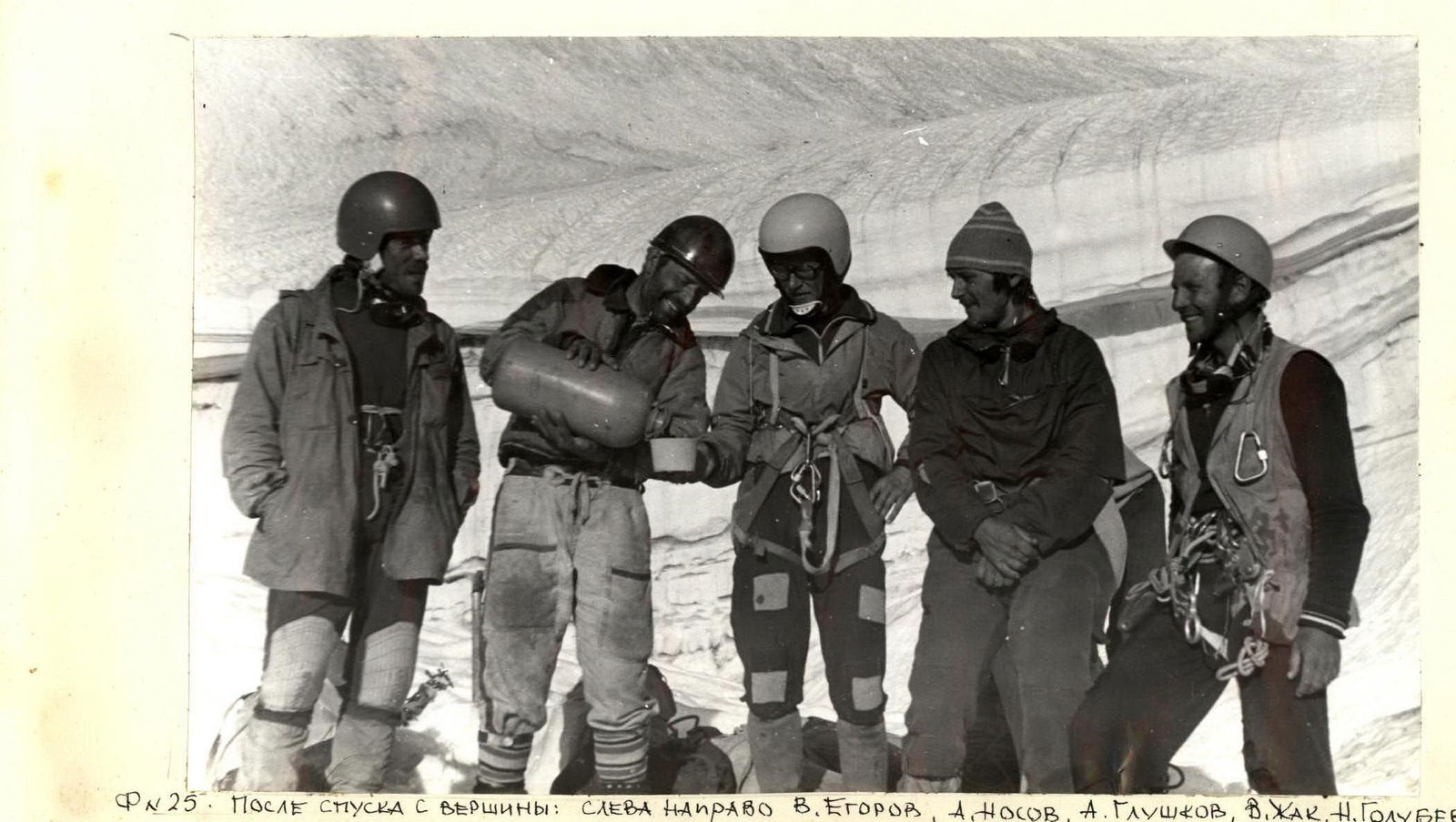
On June 9, 1981, the team as part of the district gathering on STP arrived in the Uzunkol area. Here, a cycle of training ascents was carried out, culminating in a control ascent along the Southern wall of Zamok 5B cat. sl. (third passage of B. Korablin's route — "Golden" at the 1978 Championship). The wall was passed in 26 hours, and the tactics and coherence of the rope teams were checked once again. From July 1 to 3, the material base was fully prepared, including two cars for the team's participation in the USSR Championship (head of the team — V. Gorodetsky). From July 4 to 11, special equipment and rations were prepared in the Ulu-Muzkol gorge while waiting for good weather. On July 11, the coaching council of the gathering decided to travel to the Southern Ushba area. From July 14 to 20, the team carefully studied the Western wall of the peak and outlined the route. Considering the technical complexity of the chosen route, the most experienced climbers were selected for the assault group:
- MS USSR Golubev N.N. — captain;
- MSMK USSR Nosova A.P.;
- CMS Zhak V.V.;
- CMS Egorov V.M.;
- CMS Glushkov A.S.
Each of them has 2–3 routes of 6 cat. sl. in their assets, and MSMK USSR Nosova A.P. has 10.
Observation group
In the observation group, which was constantly on the moraine of the glacier in the upper base camp, 1.5 hours' walk from the route, the following took turns:
- MS USSR Fedotov Yu.N.,
- MS USSR Dzhigraev Yu.,
- CMS Maleev V.V.,
- Korotkov K.G.,
- Vorobev A.B.,
- Vardanov E.L.,
- Aganasyan E.L.,
- Gorodetsky V.I.,
- Savelyev A.S. and
- doctor Tyukavin A.I.
The observation group had reliable radio communication with the team and the main base camp and a 60x spyglass. The base camp of our gathering was located near the "Khergiani glade" and had stable radio communication on the "Polosa" frequency with the Elbrus region KSP and the Alpine camps administration in Nalchik, constantly received weather reports and served as a link between the KSP and the alpine gatherings in the Ushba area. (See observation diary in the appendix).
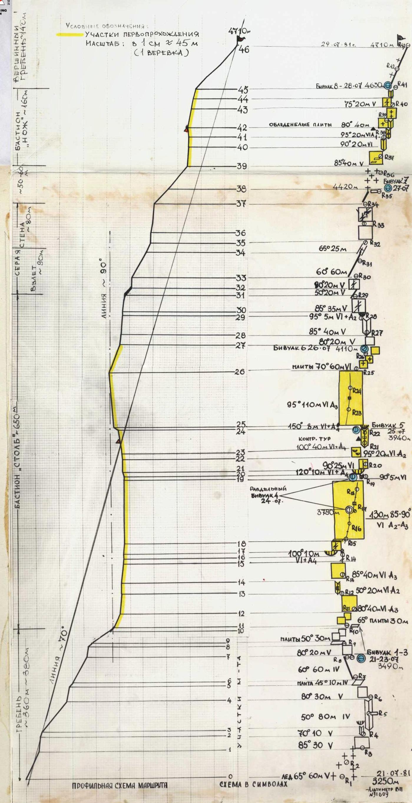
TABLE OF MAIN ROUTE CHARACTERISTICS. numerator — insurance and denominator — I.T.O.
Date     | Section No. | Av. cr. gr. | Length m | Relief characteristic                          | Cat. dif. | Condition                      | Weather conditions | ROCK piton | ice | il
---------|-------------|-------------|-----------|-------------------------------------------------|----------|--------------------------------|--------------------|------------|-----|----
34–35    | ~80         | 20          |           | ice couloir-shelf under grey bastion          | 5        | ice, pitons go into the         | good               | 3          |     | I
35–36    | 90          | 40          |           | grey wall                                     | 6        | monolith, small cracks and small holds       | —                  | 2          |     | 7
36–37    | 85          | 40          |           | grey wall                                     | 6        | —                              | —                  | 3          |     | 4
37–38    | 50          | 40          |           | counterforce from a series of walls (3–5 m) with a shelf on top | 5        | icy in depressions, monolith, bivouac No. 7 | —                  | 5          |     | облачно!
Departure at 0:30, stop at bivouac at 30:30. Travel time 13 hours. Bivouac lying down.
38–39    | 45–50      | 0           |           | snow-ice slope                            | 4        | ice under the wall                 | good               | to I       |     |
39–40    | 85          | 40          |           | system of walls.                                 | 5        | block-like, many ledges, marbles, live stones | —                  | I          |     | 8
28.07    | 40–41      | 90          | 20        | chimney about 1.5 m                               | 6        | filled with water, ice               | good               | I          |     | 2
8        | 41–42      | 95          | 20         | internal angle under a niche                            | 6        | —                              | —                  | 1/2        |     | 4
Control lap
42–43    | 80          | 40          |          | slab                                           | 6        | icy, cracked gap         | —                  | 5          |     | I
43–44    | 75          | 20          |          | wall with a crevice                              | 5        | destroyed granite             | —                  | I          |     | 5
44–45    | 70–75      | 20          |          | internal angle leading to the ridge           | 5        | wet, ice, crevices          | fog                | 2          |     | 4
Departure at 7:40, bivouac at 19:00. Travel time 10 hours. Bivouac lying down. There is snow.
29.07    | 45–46      | 45          | 120       | summital ridge                               | 4        | snow, rocks                    | good               | via ice axes |     |
Departure at 5:25. Peak at 6:15. Descent via the Red angle to the Ushba glacier

Total: 1600 meters, of which 5–6 category of difficulty — 1270 m, 6 cat. sl. — 735 m.
Height difference 1460 m. Average slope of the route – 68–70°, wall part – 90°.
131/29 7/0 3/0 117/106
Brief explanation to the tables of characteristics and symbols
APPROACH. The assault camp and observation camp were located on a high moraine at the confluence of the South-Shkheldinsky and Ushbinsky glaciers. Sites, water. From the bivouac, crossing the body of the Ushbinsky glacier, exit to the "Western wall glacier of South. Ushba" located opposite. Ascent along the left side, bypassing crevices to the sources of the glacier. In the right part of the circus, to the left of the ice gorge, behind the bergschrund — exit along the ice cushion to the Western ridge. (from the bivouac 2 hours 30 minutes)
The route passes through three rock belts:
- I — lower rock belt: includes the steep part of the ridge limiting the Western glacier from the west (height difference of the belt is about 360 m from the beginning of the route to the base of the "pillar"). Sections of the route R0–R2, R4, and R5 cat. sl. were passed earlier.
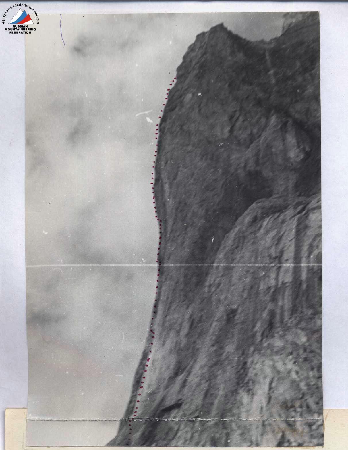
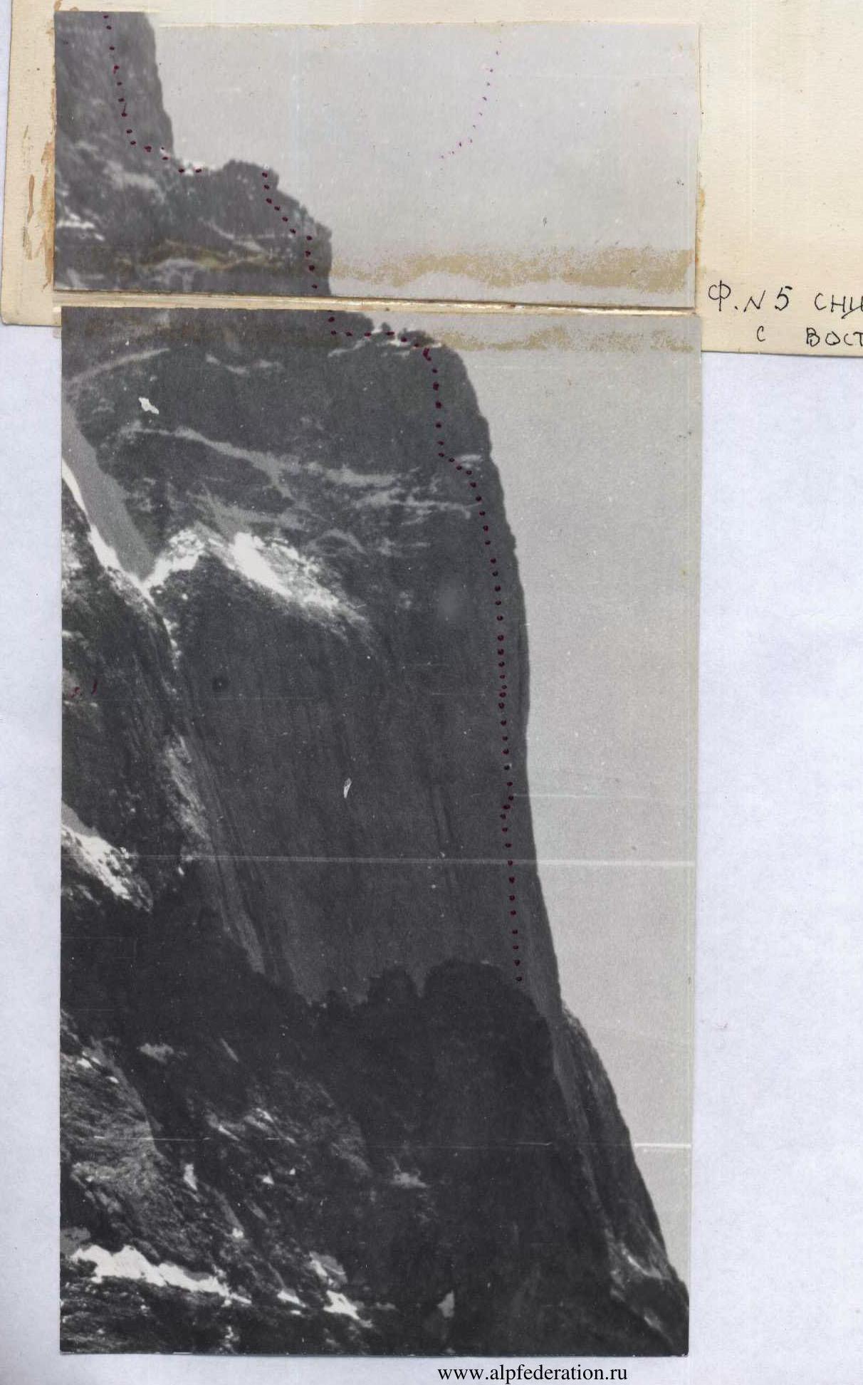
- II — middle rock belt: consists of the "pillar" bastion (about 650 m) and two rock walls above the "pillar" (about 100 m). Conditionally sections R2–R37. Sections R2–R26 — the key place of the route.
Section R12–R13. Steepness 85°, length 40 m. Wall of tile-like structure with small gaps for petal hooks. Organization of insurance and self-insurance is difficult. Insurance is in hang.
Section R13–R14. Steepness 90°, length 20 m, 6. Internal angle with wide gaps for "anchor points", extremely difficult climbing using I.T.O. Insurance from a platform.
Section R14–R15. Steepness 85°, length 40 m, 6. Wall with holds facing the opposite direction. Difficult climbing using I.T.O. Insurance from a platform.
Section R15–R16. Steepness 85°, length 15 m, 6. Wall with a good crevice, monolith. Free climbing.
Section R16–R17. Cornice. Steepness 100°, length 10 m, 6. Cornice made of blocks. Between blocks, convenient crevices for "anchor points" and wide flanges. Passed using I.T.O. Insurance from a platform. When descending from processing, securing the lower end of the rope is required.
Section R17–R18. Steepness 85°, length 15 m, 6. Wall with blocks and horizontal breaks passed by difficult free climbing.
Section R18–R19. Steepness 90°, length 130 m, 6B cat. sl. Wall with a crevice. Monolith. Complex climbing requiring the use of I.T.O.
4
 I.T.O. Insurance in hang. After 80 m, organization of a hanging bivouac is possible.
Section R19–R20. Steepness 90°, length 5 m, 6. Internal angle leading under a cornice. Monolith. Complex climbing using I.T.O.
Section R20–R21. Steepness 120°, length 10 m, 6. Cornice with an overhang up to 2 m with a crevice. Extremely complex climbing. The section is passed without the use of piton hooks using "anchor points". Insurance from a platform. Observation of the first climber is difficult.
Section R21–R22. Steepness 90°, length 25 m, 6. Monolith with a crevice. Passed by free climbing. Climbing is extremely difficult. Insurance in hang.
Section R22–R23. Steepness 95°, length 20 m, 6. Wall with a series of small cornices. Passed using I.T.O. Insurance from a platform.
Section R23–R24. Steepness 100°, length 35 m, 6. Monolithic wall with a crevice. The section is passed entirely using I.T.O. (mainly "anchor points"). Insurance from a platform.
Section R24–R25. Steepness 150°, length 8–10 m, 6. Cornice with an overhang up to 4 m. The cornice is intersected by a crevice. Very inconvenient insurance spot. Insurance from a platform. Passed on I.T.O. ("anchor points").
Section R25–R26. Steepness 95°, length 110 m, 6. Wall with a stepped crevice and a series of small cornices with a flight of up to 0.4 m. Passed on I.T.O. Insurance spots are very inconvenient. Insurance from a platform. Water flows from the rocks in the upper part of the section. Ice in the morning.
Section R26–R27. Steepness 70°, length 50 m, 6. Slabs filled with ice accretion. Complex climbing. Insurance sitting in a harness. Ice pitons were used for passage. Falling stones from the upper bastion are possible!!!
Section R29–R30. Steepness 95°, length 5 m, 6. Cornice with a crevice. Ice in the crevices. Passed using I.T.O. Insurance in hang.
Section R35–R36. Steepness 90°, length 40 m, 6B cat. sl. Grey wall with small holds and cracks. Extremely complex climbing. Organization of piton insurance is difficult. The section was passed using anchor points.
Section R36–R37. Steepness 85°, length 40 m, 6B cat. sl. Monolith with cracks and small holds. Complex climbing. Insurance is difficult — in hang in a harness.
Section R40–R41. Steepness 90°, length 20 m, 6. Chimney. Granite with marbles. Water in the chimney. Complex climbing.
Section R41–R42. Steepness 95°, length 20 m, 6. Internal angle leading under a niche. Filled with water, ice in the crevices. Passed using I.T.O.
Section R42–R43. Steepness 80°, length 40 m, 6. Slab. Filled with ice. During the day — ice with water. Climbing is extremely difficult. There is a convenient insurance spot in the middle of the section.
I.T.O. Insurance in hang. After 80 m, organization of a hanging bivouac is possible.
Section R19–R20. Steepness 90°, length 5 m, 6. Internal angle leading under a cornice. Monolith. Complex climbing using I.T.O.
Section R20–R21. Steepness 120°, length 10 m, 6. Cornice with an overhang up to 2 m with a crevice. Extremely complex climbing. The section is passed without the use of piton hooks using "anchor points". Insurance from a platform. Observation of the first climber is difficult.
Section R21–R22. Steepness 90°, length 25 m, 6. Monolith with a crevice. Passed by free climbing. Climbing is extremely difficult. Insurance in hang.
Section R22–R23. Steepness 95°, length 20 m, 6. Wall with a series of small cornices. Passed using I.T.O. Insurance from a platform.
Section R23–R24. Steepness 100°, length 35 m, 6. Monolithic wall with a crevice. The section is passed entirely using I.T.O. (mainly "anchor points"). Insurance from a platform.
Section R24–R25. Steepness 150°, length 8–10 m, 6. Cornice with an overhang up to 4 m. The cornice is intersected by a crevice. Very inconvenient insurance spot. Insurance from a platform. Passed on I.T.O. ("anchor points").
Section R25–R26. Steepness 95°, length 110 m, 6. Wall with a stepped crevice and a series of small cornices with a flight of up to 0.4 m. Passed on I.T.O. Insurance spots are very inconvenient. Insurance from a platform. Water flows from the rocks in the upper part of the section. Ice in the morning.
Section R26–R27. Steepness 70°, length 50 m, 6. Slabs filled with ice accretion. Complex climbing. Insurance sitting in a harness. Ice pitons were used for passage. Falling stones from the upper bastion are possible!!!
Section R29–R30. Steepness 95°, length 5 m, 6. Cornice with a crevice. Ice in the crevices. Passed using I.T.O. Insurance in hang.
Section R35–R36. Steepness 90°, length 40 m, 6B cat. sl. Grey wall with small holds and cracks. Extremely complex climbing. Organization of piton insurance is difficult. The section was passed using anchor points.
Section R36–R37. Steepness 85°, length 40 m, 6B cat. sl. Monolith with cracks and small holds. Complex climbing. Insurance is difficult — in hang in a harness.
Section R40–R41. Steepness 90°, length 20 m, 6. Chimney. Granite with marbles. Water in the chimney. Complex climbing.
Section R41–R42. Steepness 95°, length 20 m, 6. Internal angle leading under a niche. Filled with water, ice in the crevices. Passed using I.T.O.
Section R42–R43. Steepness 80°, length 40 m, 6. Slab. Filled with ice. During the day — ice with water. Climbing is extremely difficult. There is a convenient insurance spot in the middle of the section.
Copy of the note taken from the peak Southern Ushba (August 29, 1981, 6:15 am). July 28, 1981, 19:00. The group of the Moscow Region Lenport Committee consisting of: Borisov B.I., Vinokurov A.F., Vinokurova S.I., Samsonov L.A., making an ascent to peak South. Ushba along the Grigorenko—Prigoda route, 6B cat. sl. Descent towards North. Ushba. The note of Elazhaitis was removed. Captain of the team N. Golubev Coach MS Yu. Dzhigraev
Photo No. 20. Grey wall. Section No. 32–33.


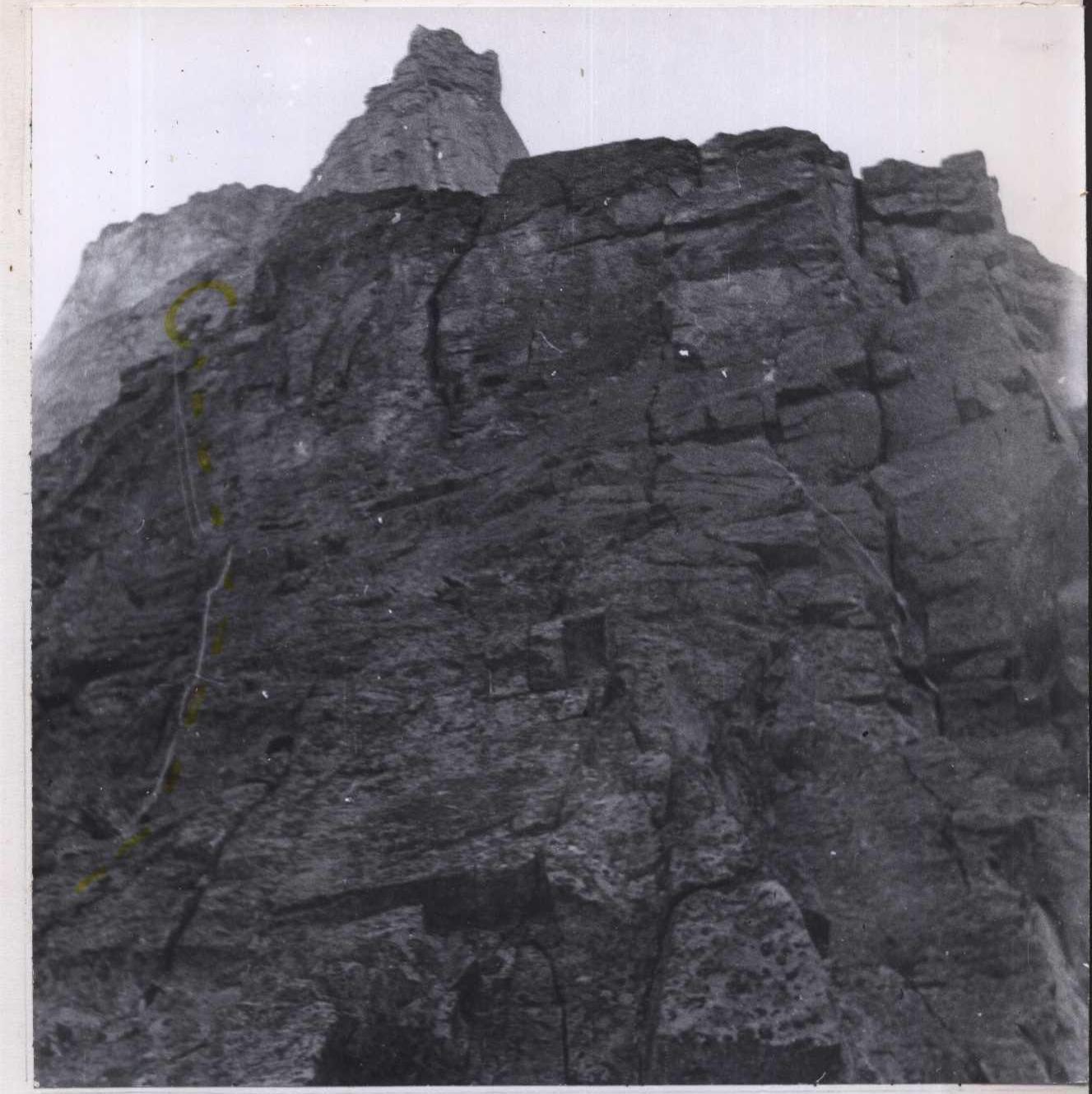
Photo No. 8. Southern section No. 3–4–5.
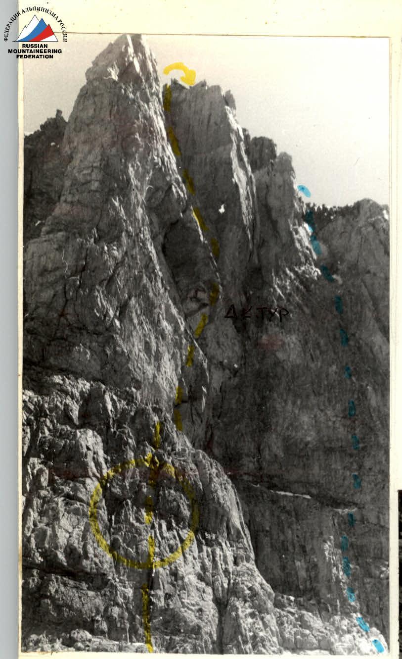
Photo No. 22. "Knife". Sections No. 39–44. Control lap No. 2.

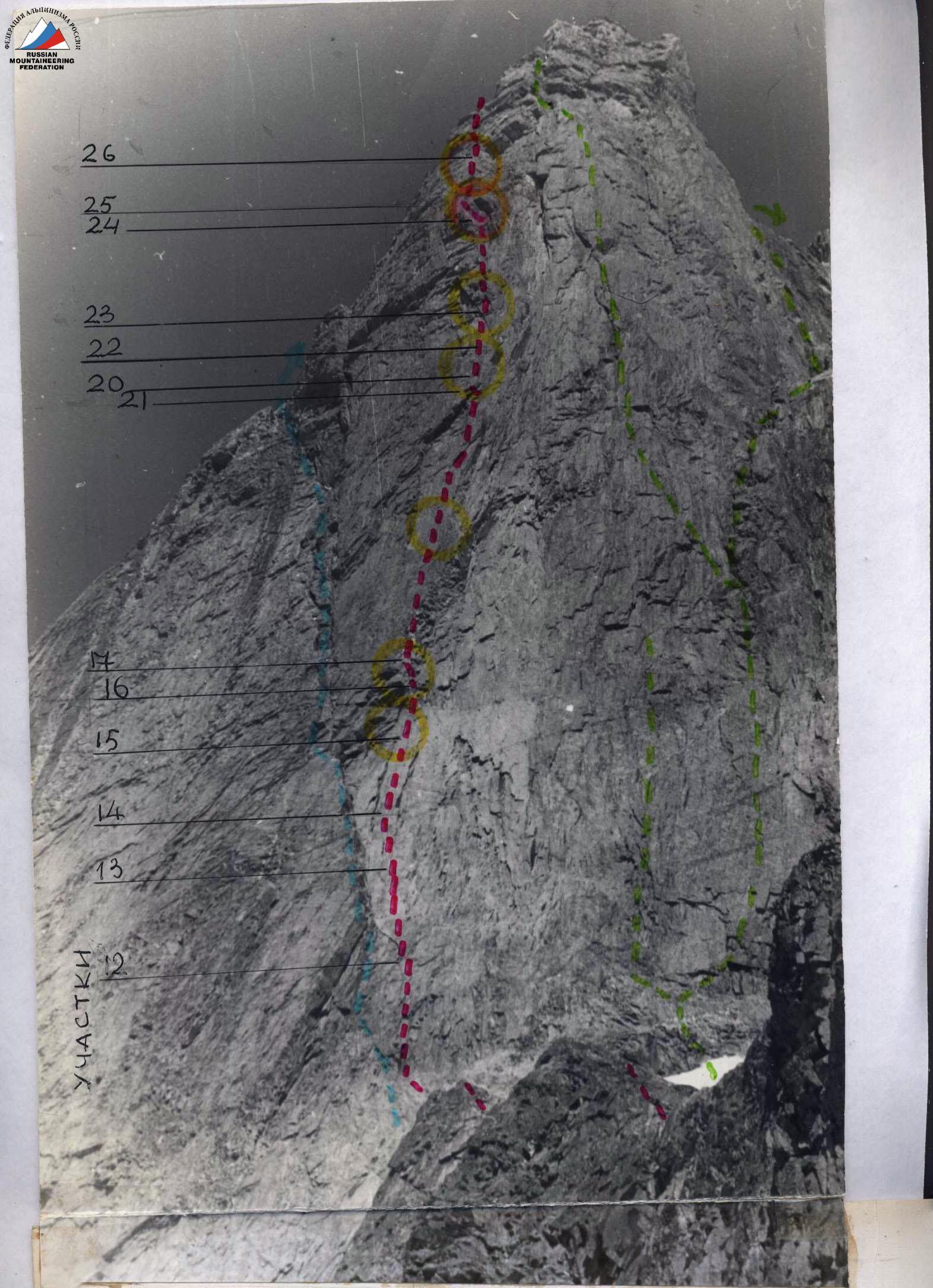
Photo No. 10. Section No. 15–16.

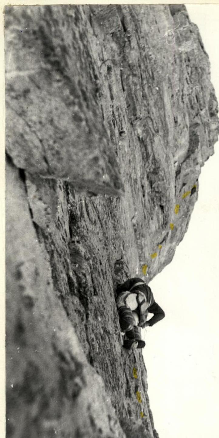
Photo No. 13. End of section 18–19. 2nd cornice above.
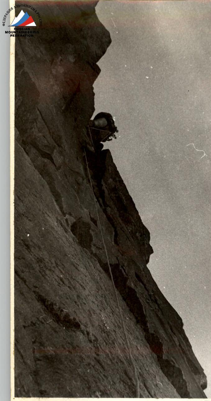 Photo No. 14. Section 20–21. First cornice passed on the platform.
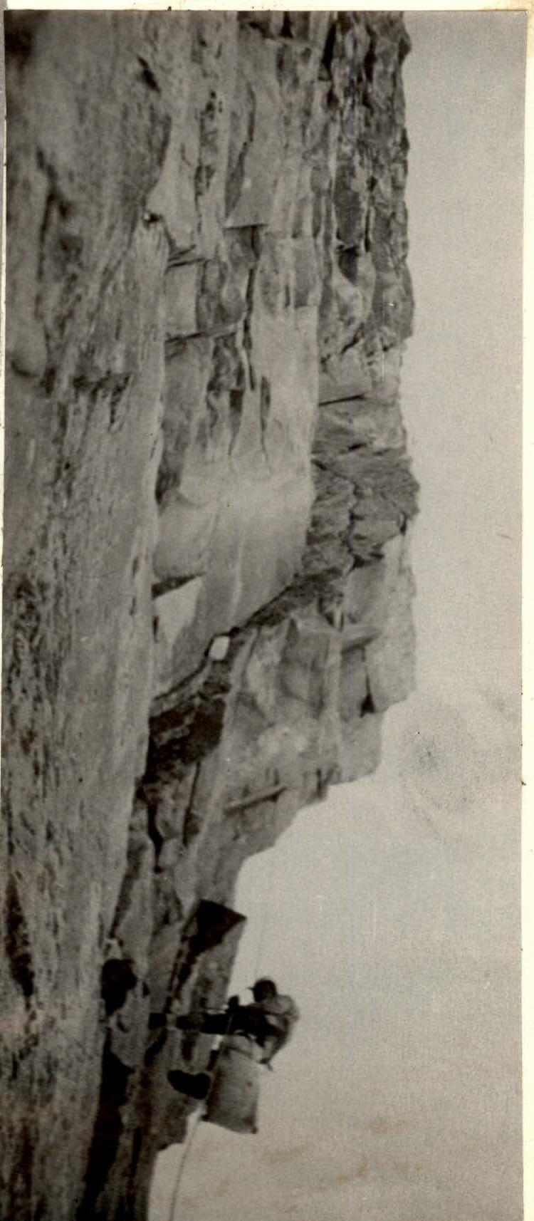
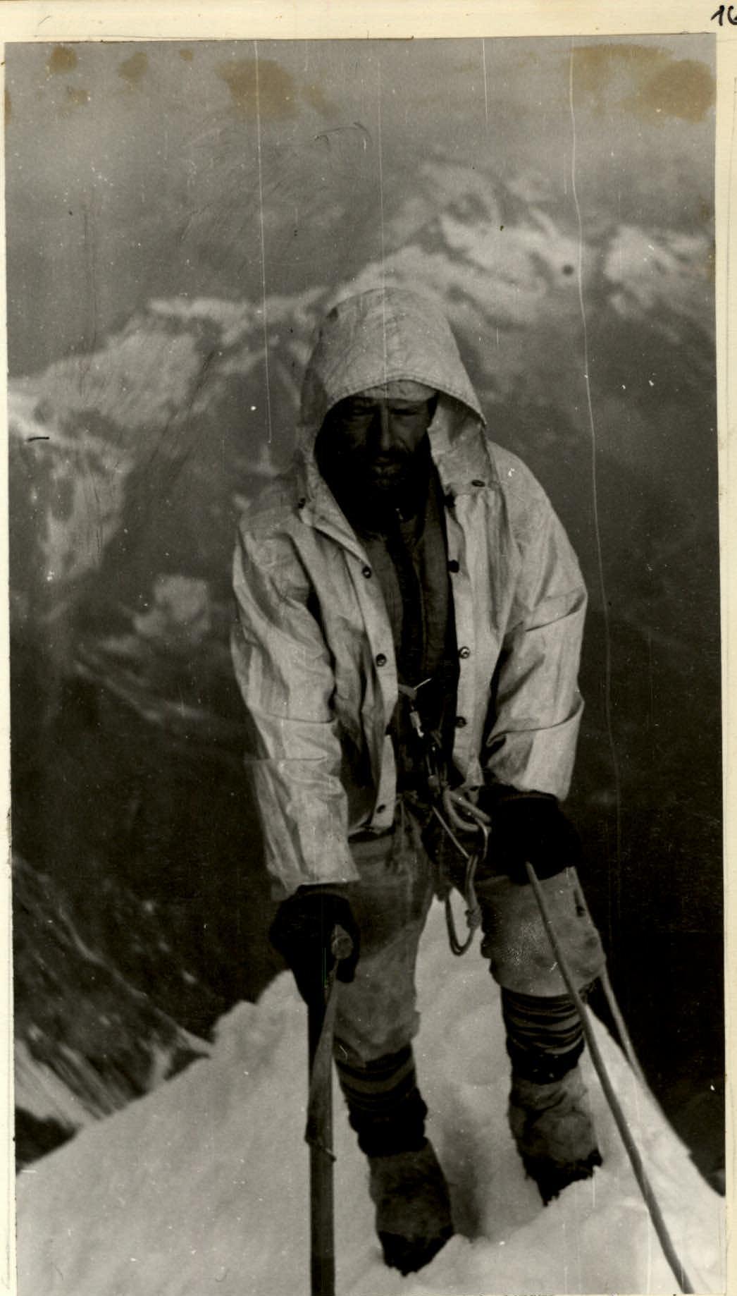 Photo No. 24. Section No. 45–46. On the summital ridge.