Report
On the ascent of Ushba North peak (4694 m) via the northeast wall through the "pillar" by the team from the Moscow Regional Sports Committee, USSR Championship 1981, technical class, first ascent
I. General Information
In accordance with the regulations of the 1981 USSR Alpine Championship, the technical class competition is held in the Caucasus.
The twin-peaked Ushba is the most popular and perhaps the most inaccessible peak in the Caucasus, attracting mountaineers for over 100 years. Ushba routes have been entered into the USSR championships around forty times. Climbers have been awarded:
- 54 gold medals;
- over 40 silver medals;
- around 10 bronze medals.
Both peaks have no easy ascent routes due to their location in one of the spurs of the Main Caucasian Ridge, with the northern peak connected to it via the northern ridge - the most accessible path to Ushba North.
The steep, dual-sloping "roof" of Ushba drops off with sheer walls to the:
- northeast;
- east;
- southeast;
- southwest;
- west;
- northwest.
Particularly challenging are the Northeast wall of Ushba North, and the Southwest and Northwest walls of Ushba South.
In the 1960s-1970s, the strongest mountaineering teams in the country focused on conquering these walls.
The Northeast wall of Ushba North is so smooth that it minimizes free climbing, requiring mostly bolted aid, and is classified as one of the so-called "industrial walls."
There are four routes of the highest category of difficulty on the Northeast wall, climbed by a team led by the renowned Soviet mountaineer M. Khergiani in 1964, and by a team led by V. Monogarov in 1968, 1971, and 1975. A section between M. Khergiani's route and V. Monogarov's 1968 route remained untraversed.
The MOSOBLSPORTKOMITET team entered this route in the USSR Championship, attempting to climb it without using pitons.
2. Route Selection
For the USSR Championship, the MOSOBLSKPORTKOMITET team submitted two possible ascent options via the Northeast wall of Ushba North.
The first involved ascending through a "large ledge" on the right side of the wall, and the second through a smooth bastion in the middle section of the planned route, known as the "pillar." The final route selection was to be determined after observing the wall from the Ushba Plateau.
The "large ledge" option was abandoned due to:
- the necessity of using pitons for most of the ascent;
- frequent rockfall and avalanches observed in the upper left couloir of the planned route.
Thus, the team chose the only feasible and safest route on the Northeast wall, between the two renowned routes - M. Khergiani's 1964 route and V. Monogarov's 1968 route.
Upon finalizing the route selection for the USSR Championship, the team thoroughly verified whether other teams, Soviet or foreign, had attempted this route. The check confirmed that no group had previously attempted this route, which was later confirmed during the ascent. The team found no evidence of previous ascents on this route and considered it a first ascent.
3. Table
of key ascent route characteristics
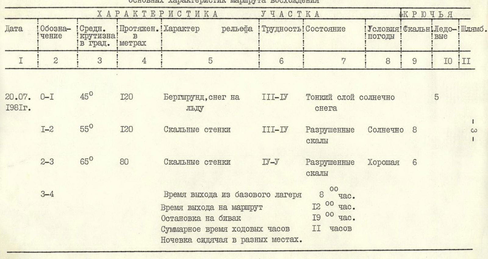
| Date | Designation | Average steepness in degrees | Length in meters | Terrain characteristics | Difficulty | Condition | Weather conditions | Rock pitons | Ice screws | Pitons |
|---|---|---|---|---|---|---|---|---|---|---|
| 20.07.1981 | R0–R1 | 45° | 120 m | Bergschrund, snow on ice | III–IV | Thin layer of sun crust | 5 | |||
| R1–R2 | 55° | 120 m | Rock walls | III–IV | Loose rocks | Sunny | 8 | |||
| R2–R3 | 65° | 80 m | Rock walls | IV–V | Loose rocks | Good | 6 | |||
| Time of departure from base camp | 8:00 | |||||||||
| Time of arrival on route | 12:00 | |||||||||
| Stop for bivouac | 19:00 | |||||||||
| Total time of travel hours | 11 hours | |||||||||
| Sitting overnight bivouac. | ||||||||||
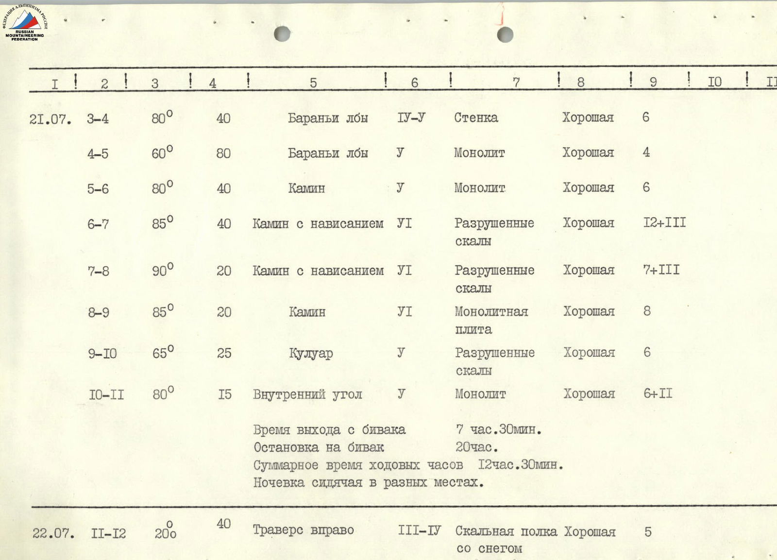
| 21.07. | R3–R4 | 80° | 40 m | Ram's foreheads | IV–V | Rock wall | Good | 6 | ||
| R4–R5 | 60° | 80 m | Ram's foreheads | V | Monolith | Good | 4 | |||
| R5–R6 | 80° | 40 m | Chimney | V | Monolith | Good | 6 | |||
| R6–R7 | 85° | 40 m | Chimney with overhang | VI | Loose rocks | Good | 12 | 3 | ||
| R7–R8 | 90° | 20 m | Chimney with overhang | VI | Loose rocks | Good | 7 | 3 | ||
| R8–R9 | 85° | 20 m | Chimney | VI | Monolithic slab | Good | 8 | |||
| R9–R10 | 65° | 25 m | Couloir | V | Loose rocks | Good | 6 | |||
| R10–R11 | 80° | 15 m | Inner corner | V | Monolith | Good | 6 | 2 | ||
| Time of departure from bivouac | 7:30 | |||||||||
| Stop for bivouac | 20:00 | |||||||||
| Total time of travel hours | 12 hours 30 minutes | |||||||||
| Sitting overnight bivouac. | ||||||||||
| 22.07. | R11–R12 | 20° | 40 m | Traverse right | III–IV | Rock ledge with snow | Good | 5 | ||
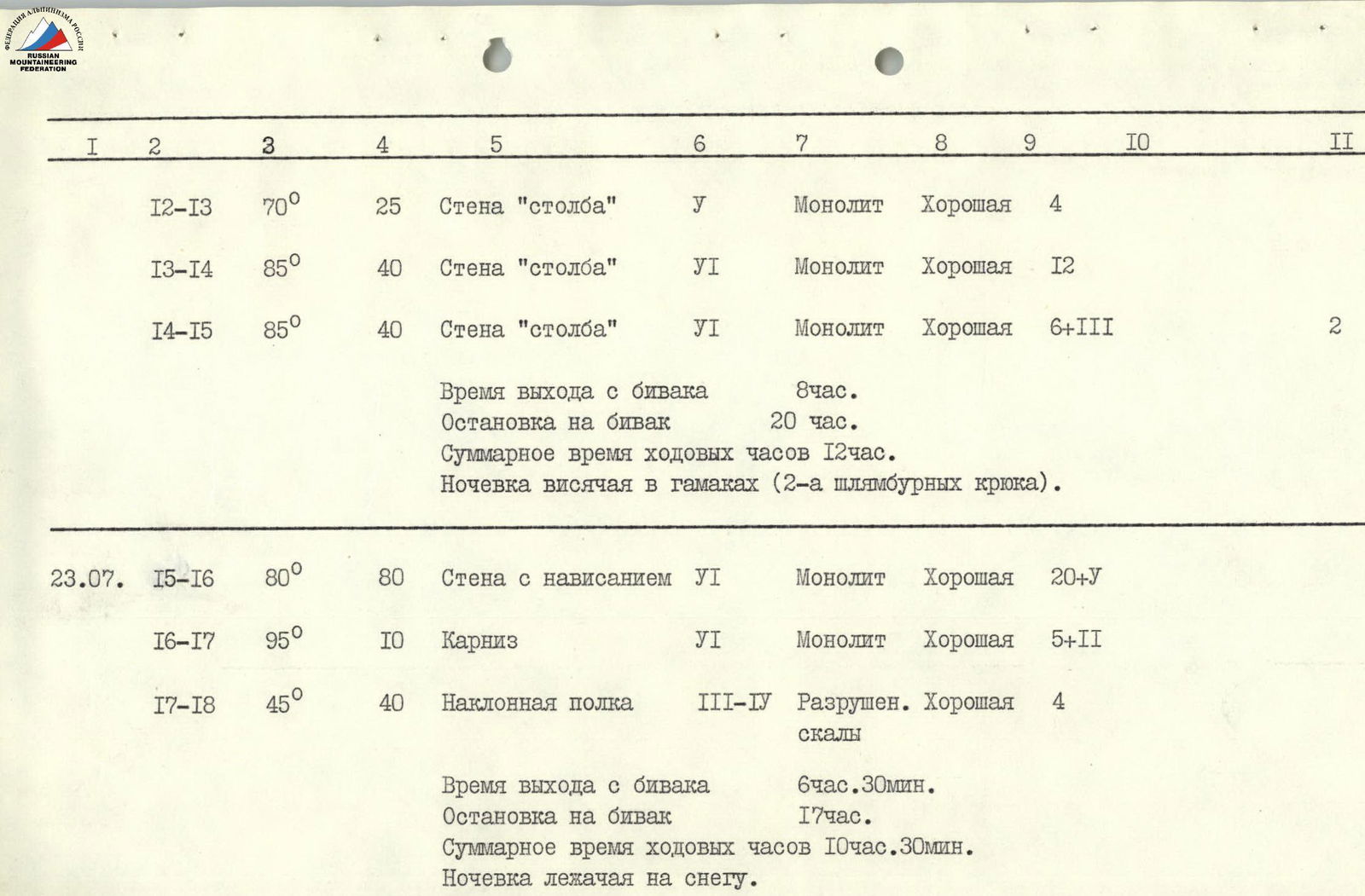
| R12–R13 | 70° | 25 m | "Pillar" wall | V | Monolith | Good | 4 | |||
| R13–R14 | 85° | 40 m | "Pillar" wall | VI | Monolith | Good | 12 | |||
| R14–R15 | 85° | 40 m | "Pillar" wall | VI | Monolith | Good | 6 | 3 | 2 | |
| Time of departure from bivouac | 8:00 | |||||||||
| Stop for bivouac | 20:00 | |||||||||
| Total time of travel hours | 12 hours | |||||||||
| Hanging bivouac in hammocks (2 pitons). | ||||||||||
| 23.07. | R15–R16 | 80° | 80 m | Wall with overhang | VI | Monolith | Good | 20 | 5 | |
| R16–R17 | 95° | 10 m | Cornice | VI | Monolith | Good | 5 | 2 | ||
| R17–R18 | 45° | 40 m | Inclined ledge | III–IV | Loose rocks | Good | 4 | |||
| Time of departure from bivouac | 6:30 | |||||||||
| Stop for bivouac | 17:00 | |||||||||
| Total time of travel hours | 10 hours 30 minutes | |||||||||
| Lying overnight bivouac on snow. | ||||||||||
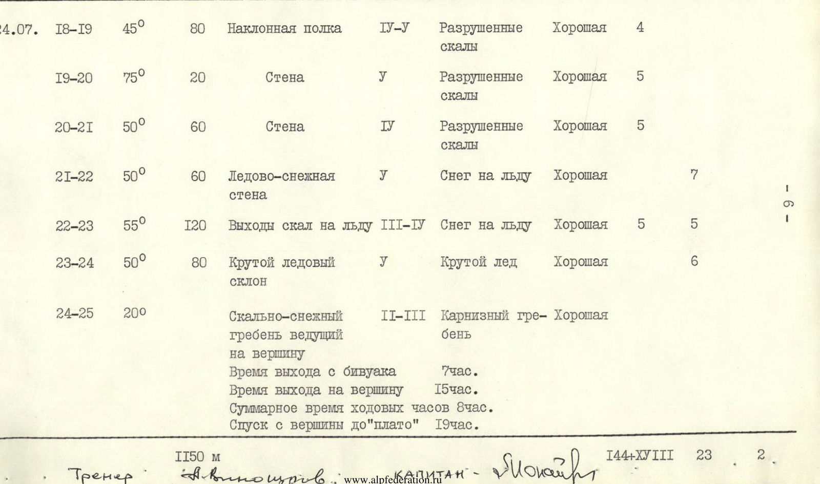
| 24.07. | R18–R19 | 45° | 80 m | Inclined ledge | IV–V | Loose rocks | Good | 4 | ||
| R19–R20 | 75° | 20 m | Wall | V | Loose rocks | Good | 5 | |||
| R20–R21 | 50° | 60 m | Wall | IV | Loose rocks | Good | 5 | |||
| R21–R22 | 50° | 60 m | Ice-snow wall | V | Snow on ice | Good | 7 | |||
| R22–R23 | 55° | 120 m | Rock outcrops on ice | III–IV | Snow on ice | Good | 5 | 5 | ||
| R23–R24 | 50° | 80 m | Steep ice slope | V | Steep ice | Good | 6 | |||
| R24–R25 | 20° | Rock-snow ridge leading to the summit | II–III | Cornice ridge | Good | |||||
| Time of departure from bivouac | 7:00 | |||||||||
| Time of arrival on summit | 15:00 | |||||||||
| Total time of travel hours | 8 hours | |||||||||
| Descent from summit to "plateau" | 3:00 |
4. Brief explanation of the table (route characteristics)
Based on the terrain characteristics and steepness, the route to Ushba North via the Northeast wall through the "pillar" can be conditionally divided into three parts:
- The lower section of the rock belt starts from the snow-rock-ice slope and ends at a clearly defined snow-ice terrace.
- The second rock belt consists of a sheer, monolithic "pillar," separated by a narrow, sheer couloir from the left part of the wall.
- The third rock belt is a sheer rock wall leading to the beginning of the Northeast ridge of Ushba North peak.
The first rock belt is climbed through a sheer chimney, partially severely damaged (section R4–R11). The chimney features many overhanging sections, traversed by the team using very complex free climbing. Movement is extremely cautious due to numerous overhanging, loose blocks.
The second rock belt, known as the "pillar" (section R12–R17), is a monolithic, relatively unfractured sheer wall. The rocks are very difficult with smooth, slightly overhanging sections, climbed by the team using both free climbing and artificial aids, but without piton technique or bolts.
The third rock belt comprises steep, averaging 65°, rocks in the upper part, broken with few cracks, complicating belay organization during the team's passage (section R18–R21).
This is followed by an ice ridge approximately 420 m long, leading to the Northeast ridge and then along a simple rock-snow ridge to the summit of Ushba North.
5. Ascent Tactics
The tactical plan for the ascent involved optimal team movement organization based on:
- observations conducted;
- studying reports of ascents on the Northeast wall;
- consultations with participants of groups that had climbed these routes.
The tactical plan submitted to the judges included breaking down the route into daily segments with approximate bivouac locations and safety measures for navigating the route:
- bivouac organization;
- movement under cover;
- double rope climbing;
- use of jumar ascenders and harnesses.
It is noted that the assessment of most of the route proved correct, and the team's movement was in line with the tactical plan.
A. Tactical plan for the ascent by days
1st day. Departure from base camp to "German bivouacs."
2–3rd day. Ascent from "German bivouacs" up the glacier to the Ushba Plateau, observing the wall and finalizing the ascent route via the Northeast wall.
4th day. Departure to the wall in good weather; otherwise, waiting on the Ushba Plateau for a day or two.
5th day. Ascent in satisfactory weather, working until the first planned bivouac at the base of the wall.
6–9th day. Work on the wall and ascent to the summit. Descent to the observers' bivouac on the Ushba Plateau in good weather.
10–11th day. Reserve days on the wall in case of bad weather.
10th day. Descent to base camp in normal weather.
12th day. Descent to base camp in bad weather.
B. Team movement tactics on the wall
Daily rotation of the lead climber (A. Karzanov, V. Boyko, V. Efimov), with the lead climber unencumbered.
All team members climb on double ropes with backpacks, using jumar ascenders and a "chest-leader" system.
Daily rotation of the last climber:
- Yu. Shchegolev;
- V. Prokopenko;
- N. Opoitsev.
Photography on the route: E. Monaenkov, Yu. Shchegolev. Bivouac preparation and catering: Yu. Kalagin.
Coordination of team movement on the route: team captain and deputy captain.
C. Safety measures and radio communication
Double ropes for each team member.
Bivouac organization:
- under overhangs;
- in areas safe from rockfall.
Organization of lower climber safety in areas with damaged terrain (under overhangs).
In case of an accident:
- light signal with a flare;
- accident below the "pillar" - descent via the ascent route;
- accident above the "pillar" - traverse to the North ridge and descent to the Ushba Plateau.
Wall to observer communication on the plateau: "Vitalka" radio set; observer to base camp communication: "Nedra" radio set.
7. Conclusion
The MOSOBLSKPORTKOMITET team's route to Ushba North via the Northeast wall through the "pillar" is logical and safe. Its technical difficulty can be compared to:
- the lower wall section - to the rocks on Chatyn peak via the "diamond";
- the upper wall section, the "pillar," to the lower section of Zamin Karor peak (S. Efimov's route).
Based on experience from joint ascents of Category 6B routes in the Caucasus and Fann Mountains (peaks Zamin Karor, Bodkhona, Chapdara, Zindon, Chatyn), the team believes that the route via the Northeast wall through the "pillar" corresponds to the technical difficulty of a Category 6B route.
The route was climbed for the first time and represents a unique variant on the Northeast wall.
Total route length: 1150 m. Total number of pitons: 144 rock, 18 ice, 23 pitons.
Team captain - Master of Sports: E. Monaenkov

Team coach - Master of Sports: A. Vinokurov
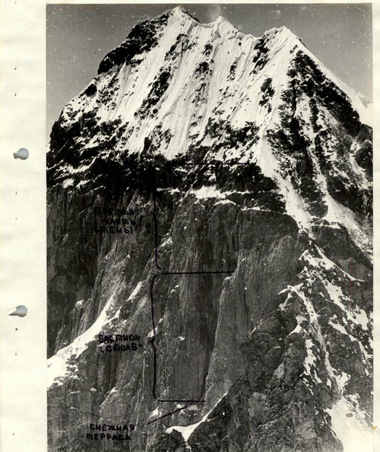
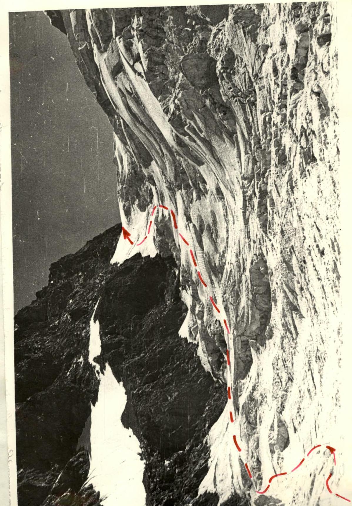
Key section of the route "pillar" (sect. R12–R17) and the third part of the wall (sect. R17–R21)
Overcoming the bergschrund at the start of the route (sect. R0–R1)
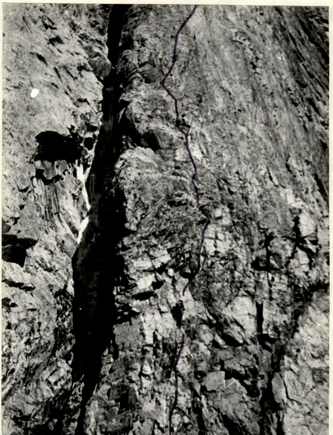
Under the cornice in the lower part of the "pillar" (sect. R12–R13)
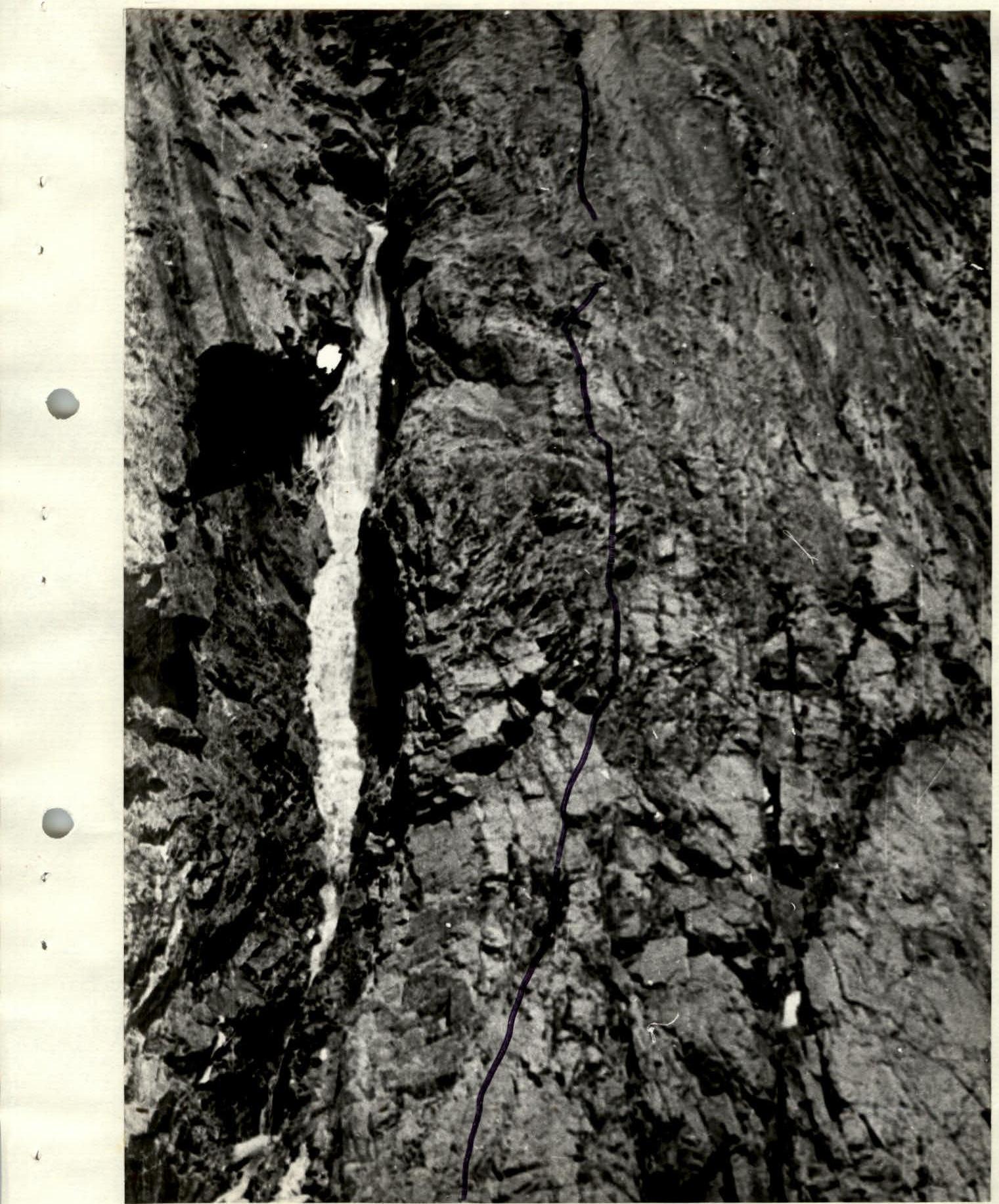
Climbing the middle part of the "pillar" (sect. R13–R14)
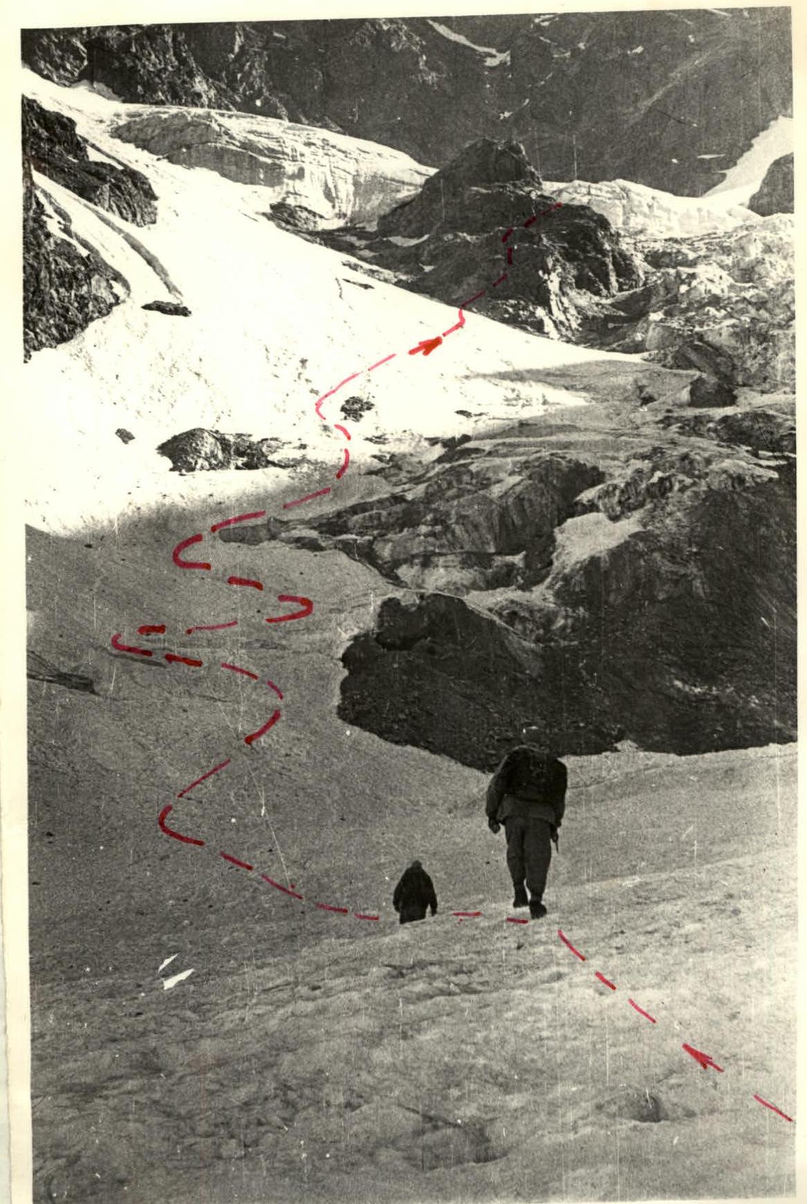
Start of ascent to Ushba Pass