ASCENT TO NORTH USHBA VIA THE EASTERN WALL /"MIRROR"/ FROM CHALAAT GLACIER /Climbing Report/
Kiev — 1968

Ascent route via the "mirror" of the Eastern wall of N. Ushba.
1. Introduction
1. Brief Characteristics of the Ushba Massif
Ushba is located in close proximity to the Main Caucasian Ridge, branching off from it near Shchurovsky Peak. The Ushba massif features two sharp peaks separated by a shallow saddle.
The north-eastern peak has an absolute height of 4695 m. A sharply descending and short ridge with a small peak, Gulba, extends from it.
The south-western (or southern) peak stands at 4710 m. The next peak in the same spur is Mazeri Peak. The southern slopes of the spur face Svaneti. To the north of the Ushba massif lies a rocky ridge that approaches the Ushba Plateau. The Ushba Glacier flows southwest from this plateau. To the west lies another, more powerful ice flow that gives rise to the Ushba Glacier.
Northeast of the massif is the basin of one of the tributaries of the Chalaat Glacier. On the eastern slopes of the massif, in the gorge formed by the slopes of the Ushba spur and the southeastern spur of the northern peak, lies the small Gul Glacier.
The western and eastern slopes of the Ushba massif are so steep that snow does not accumulate here. The reddish slopes of Ushba rise above this realm of snow and ice.
The name of the massif translates from the Svan language to Russian as "lair of witches," and from Georgian as "fatal."
2. Sporting Characteristics of Ushba
Ushba is one of the most popular peaks among Soviet and foreign climbers.
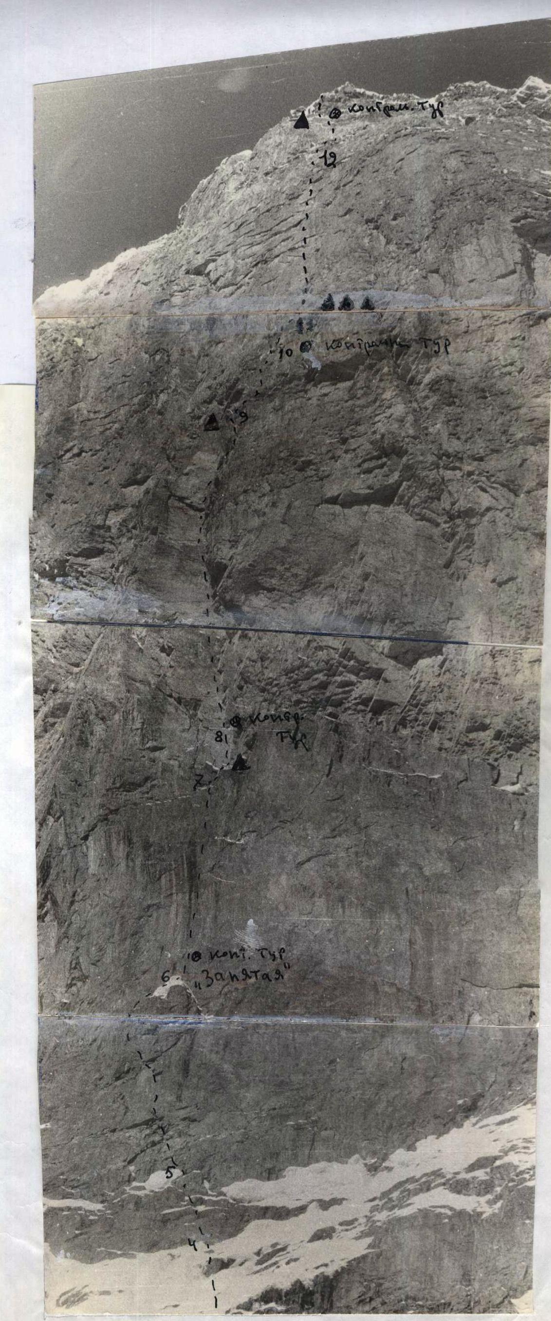 Central part of the wall. Sections: R4–R5, R5–R6, R6–R7, R7–R8, R9–R10, R10–R11, R11–R12.
The ascent of the northern peak of Ushba's walls began only in the post-war years. In 1946, a group consisting of A. Maleinov (team captain), B. Garf, V. Miklashevsky, and G. Karavaev ascended North Ushba via the northwestern wall, marking the beginning of the conquest of North Ushba's walls.
In 1947, M. Lepnev and G. Skornyakov ascended North Ushba via the northwestern wall, and in 1956, I. Erokhin's group made an ascent slightly to the right of M. Lepnev and G. Skornyakov's route. In the same year, V. Staritsky's group ascended the northern peak of Ushba from the Gul Glacier via the eastern wall.
Wall routes to North Ushba from the Chalaat Glacier began to be explored only in recent years.
In 1964, V. Monogarov's group ascended via the eastern wall (to the right of V. Staritsky's route). In the same year, M. Khergiani's group also ascended North Ushba via the eastern wall.
The so-called "mirror" of the eastern wall of North Ushba remained unascended.
In 1966, A. Kustovsky's group traversed 40 m of the lower part of the wall up to the "comma." In 1967, V. Monogarov's group reached the same point. Both groups of Ukrainian climbers were forced to retreat due to severe weather.
The reasons for the late exploration of Ushba's walls from the Chalaat Glacier are:
a/ Most routes present significant technical difficulties and can only be overcome using the full arsenal of advanced mountaineering techniques;
b/ The "mirror" of the Eastern wall of North Ushba has a negative slope, making it extremely challenging to overcome;
c/ The approach to the walls from the Ushba Plateau is blocked by the Chalaat Pass, a path that is quite complex and, with significant snow accumulation on the slopes of Chatyn, dangerous.
Approaches via:
- Becho Pass,
- Gul Pass,
- the lower step of the Chalaat Glacier — are too long (see map),
and overcoming the lower part of the Chalaat Glacier's icefall presents technical challenges.
II. Information about the Climbing Group
a/ Composition of the Assault Group
The combined team of climbers from the CS DSO "Avangard" in 1968 mainly consisted of participants from the assault group that attempted to ascend the Eastern wall of North Ushba in 1967.
The group has years of experience climbing peaks of the highest difficulty categories both in Soviet mountain ranges and abroad.
The assault group included, for the first time, Candidate Master of Sports of the USSR, Oleg Grippa, who had completed several challenging ascents:
- Shchurovsky Peak via the western wall — 5B category difficulty
- Ushba from the south — 5B category difficulty
- Eastern Shkhelda — 5A category difficulty
All members of the assault group were registered for
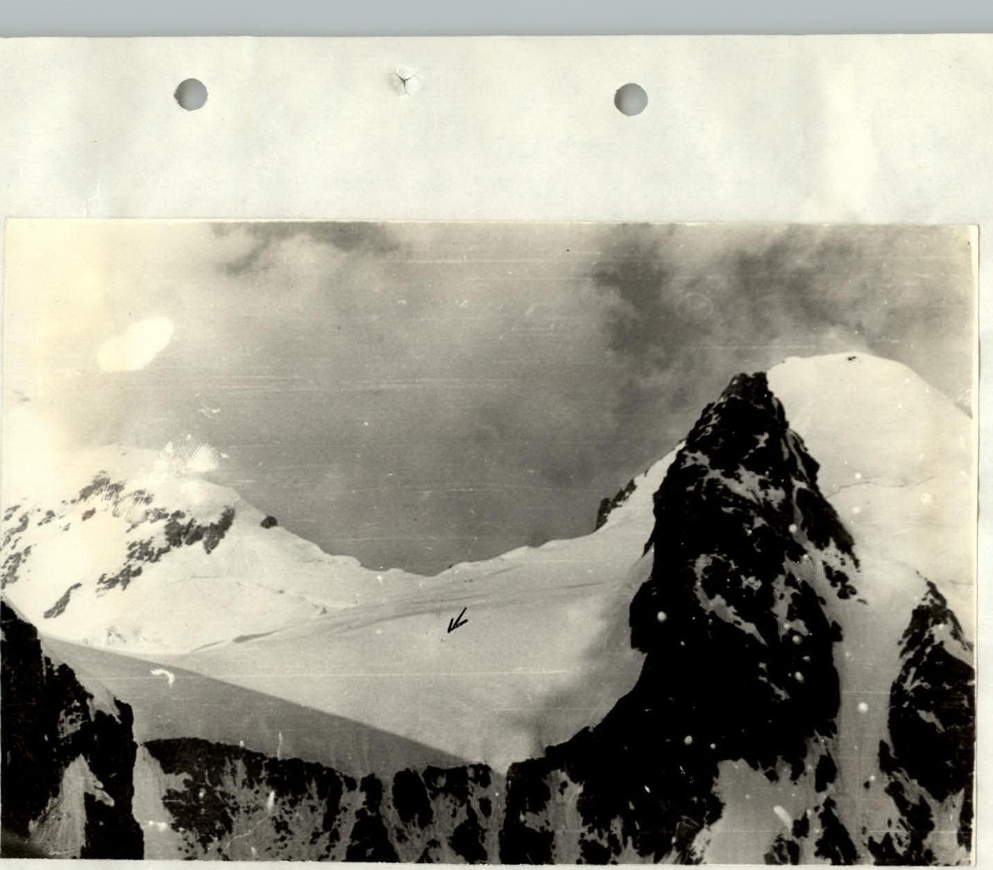 View from the wall to the Ushba Plateau /figures of two observers are indicated by an arrow/.
participation in the competition for the best achievement of the 1968 season in the class of technically complex ascents. The registration was done according to the established form, complying with all requirements specified in § VII, paragraphs 28–32.
The preparation and execution of the ascent were led by Honored Coach of the Ukrainian SSR, Honored Master of Sports of the USSR, Vladimir Monogarov. The deputy leader of the group was Master of Sports of the USSR, Mikhail Aleksiuk. Master of Sports of the USSR, Dmitry Lavrenenko, was appointed as the head of the training camp and coach.
b/ Composition of the Observation Group. Organization of Communication and Observation
The observation group consisted of two people: Alexander Shcherbakov (III sports category) — leader, and Mikhail Filippov (III sports category).
The observation group had a portable "Nedra" radio station, a set of colored flares for light signaling, and binoculars.
The observation group was tasked with:
- Continuously observing the movement of the assault group on the wall, recording the time taken to traverse sections of the route, and maintaining an observation log.
- Establishing regular communication with the assault group using the radio station and signal flares.
- In the event of an accident in the assault group, informing the leader of the second group, the KSP of the Elbrus region, and the leadership of the "Elbrus" alpine camp.
| Surname, First Name, Patronymic | Sports Rank | Year of Birth | Party Membership | Nationality | Sports Experience | Main Profession | Place of Residence |
|---|---|---|---|---|---|---|---|
| Monogarov Vladimir Dmitrievich | Master of Sports | 1926 | CPSU member | Ukrainian | 1946 | Lecturer | Kiev-111, Saratovskaya, house 10a, apartment 36 |
| Mashchenko Nikolai Mikhailovich | Master of Sports | 1935 | Non-party | Ukrainian | 1954 | Electrician | Kiev, Grekova Street, house 13, apartment 1 |
| Aleksiuk Mikhail Mironovich | Master of Sports | 1932 | Non-party | Russian | 1952 | Engineer | Kiev-121, Entuziastov, house 19/1, apartment 154 |
| Grippa Oleg Illarionovich | Candidate for Master | 1938 | Non-party | Ukrainian | 1956 | Lecturer | Simferopol, Krasnodonskaya, 5, apartment 30 |
| Lavrenenko Dmitry Ivanovich | Master of Sports | 1933 | CPSU member | Ukrainian | 1953 | Lecturer | Kiev-125, Perova Boulevard, 1/8, apartment 51 |
| Goncharov Vladlen Konstantinovich | Master of Sports | 1938 | Non-party | Russian | 1956 | Lecturer | Simferopol, Primorskaya, 41 |
The cornices along the entire wall, especially in its middle part, presented particular complexity. Passing these sections required special techniques and equipment.
The ascent was planned to proceed via steep snow and simple rocks to the beginning of the "mirror," then straight up to the snowy ridge of the pre-summit tower, exiting onto the ridge of North Ushba, which would be followed to the summit and descent to the Ushba Plateau.
IX. Organizational and Tactical Plan of the Ascent
1. Organizational Plan of the Ascent
The plan provided for a uniform, sequential preparation of the entire team for the planned ascent, taking into account gradually increasing loads and allocating sufficient time for observing the wall.
The plan was brought to the attention of the representative of the Alpine Federation of the USSR, Master of Sports Ivan Ivanovich Antonovich.
During the ascent, this plan was not altered.
2. Tactical Plan of the Ascent
The tactical plan for the ascent was as follows: movement without initial processing of the route. On sections of free climbing, movement was done in pairs with periodic changes of the lead.
On the average steep part of the route, where platforms and ladders were required, the tactic was as follows: 3 people ensured upward progress (Monogarov, Mashchenko, Goncharov), while the other 3 performed the labor-intensive task of pulling up backpacks weighing around 160 kg.
Here, preliminary route processing for the next day's work was applied. This distribution of duties and tactics was dictated by the clear specialization of participants in overcoming the complex 600-meter section of the wall.
The lead climbers changed every 20–30 meters. Given that a maximum of 100 m was covered in a day, each member of the lead trio covered 30 m.
The lead climber was insured by two ropes and two belayers. The ropes passed through each of the hung carabiners in turn, making it easy to pull them through one by one.
Moreover, 2 ropes guaranteed the safety of the lead climber in case of a fall.
The route was planned to start early in the morning. Overnight stays were planned to be hanging in hammocks and sitting on platforms, which could be organized anywhere on the route.
Each participant was to receive food for the entire day in the form of a separate bag and a flask of water, as gathering more than 2 people in one place during the ascent was difficult.
This tactic of movement along the route proved itself fully and ensured safety, clear work, and rest at the bivouacs. The work duration was planned for 12 hours a day.
Main Characteristics of the Ascent Route to North Ushba via the Eastern Wall "Mirror" from Chalaat Glacier
- Wall height vertically without the ridge — 1240 m, by length — 1455 m, including the most difficult sections:
-
- overhanging — 310 m
-
- with a slope of 80–90° — 241 m
-
- with a slope of 70–75° — 105 m
-
- Average slope of the rocky part of the route — 86°
- Average slope of the snow-ice part of the route — 51°
- Free climbing — 960 m
- With the use of artificial footholds — 280 m
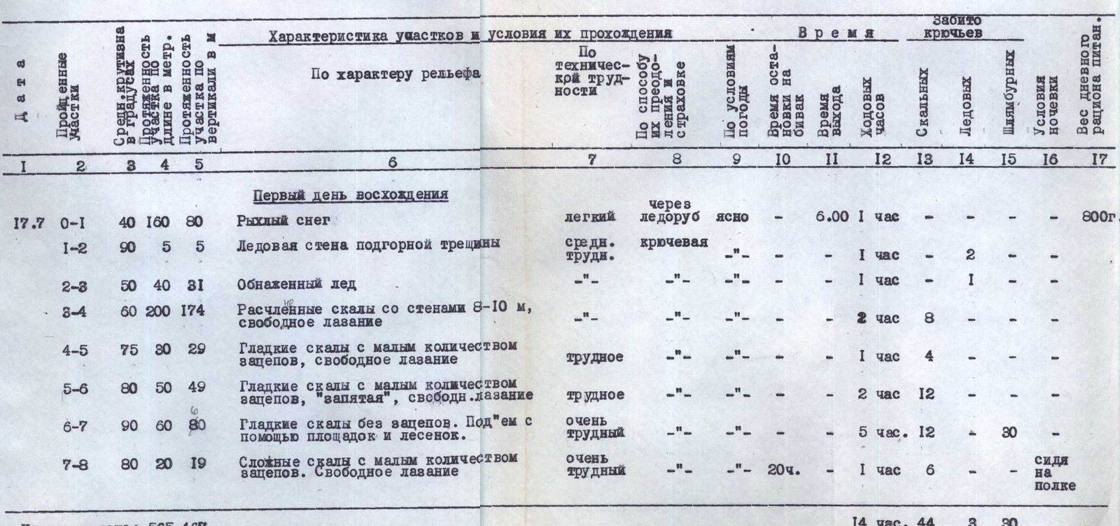
First Day of Ascent (July 17, 1968)
- R0–R1: Loose snow. Easy. Via ice axe. Clear. Started at 6:00, covered in 1 hour. Weight of daily ration: 800 g.
- R1–R2: Ice wall under the bergschrund. Medium difficulty. Pitons. Covered in 1 hour. (Ice pitons: 2).
- R2–R3: Exposed ice. Medium difficulty. Pitons. Covered in 1 hour. (Ice pitons: 1).
- R3–R4: Dissected rocks with walls 8–10 m, free climbing. Medium difficulty. Pitons. Covered in 2 hours. (Rock pitons: 8).
- R4–R5: Smooth rocks with few holds, free climbing. Difficult. Covered in 1 hour. (Rock pitons: 4).
- R5–R6: Smooth rocks with few holds, "comma," free climbing. Difficult. Covered in 2 hours. (Rock pitons: 12).
- R6–R7: Smooth rocks without holds. Ascended using platforms and ladders. Very difficult. Covered in 5 hours. (Rock pitons: 12, expansion bolts: 30).
- R7–R8: Complex rocks with few holds. Free climbing. Very difficult. 20 hours. Covered in 1 hour. (Rock pitons: 6). Overnight stay sitting on a ledge.
Total for the day: 565 m vertically, 467 m in length. Time taken: 14 hours 44 minutes. (Pitons: 3 ice, 30 expansion bolts).
Second Day of Ascent (July 18, 1968)
- R8–R9 (100° overhang, 90 m vertical, 100 m length): Smooth overhanging rocks. Ascended using platforms and ladders. Very difficult. Pitons. Clear. Started at 18:00, covered in 6:00, 12 hours. (Rock pitons: 24, expansion bolts: 46). Overnight stay hanging, sitting on a platform. Weight of daily ration: 800 g.
Total for the day: 90 m vertically, 100 m in length. Time taken: 12 hours 24 minutes. (Expansion bolts: 46).
Third Day of Ascent (July 19–22, 1968)
- July 19. R9–R10 (100° overhang, 70 m vertical, 70 m length): Smooth overhanging rocks. Ascended using platforms and ladders. Very difficult. Pitons. Clear. Started at 7:00, covered in 10:00, 14 hours. (Expansion bolts: 36). Weight of daily ration: 800 g.
- July 19. R10–R11 (80°, 20 m vertical, 19 m length): Smooth rocks with few holds. Free climbing. Pitons. Clear. Started at 19:00, covered in 2:00, 6 hours. (Expansion bolts: 3). Overnight stay sitting on a ledge.
Total for July 19: 90 m vertically, 89 m in length. Time taken: 12 hours 20 minutes. (Expansion bolts: 39).
- July 20. R11–R12 (100° overhang, 40 m vertical, 40 m length): Processing of an overhanging black, wet wall using platforms and ladders. Very difficult. Pitons. Fog. Covered in 5:00, 6 hours. (Expansion bolts: 20). Overnight stay sitting on a ledge. Weight of daily ration: 800 g.
- July 21: Waiting out bad weather. Fog. Overnight stay sitting on a ledge. Weight of daily ration: 800 g.
- July 22: Waiting out bad weather. Fog. Overnight stay sitting on a ledge. Weight of daily ration: 800 g.
Fourth Day of Ascent (July 23, 1968)
- R11–R12: Passage along the processed section. Very difficult. Pitons. Fog. Started at 7:00, covered in 2:00. Weight of daily ration: 800 g.
- R12–R13 (100° overhang, 100 m vertical, 100 m length): Smooth overhanging rocks with few holds. Ascended using platforms and ladders. Pitons. Fog. Started at 19:00, covered in 10:00, 20 hours. (Expansion bolts: 43). Overnight stay sitting on a ledge.
Total for the day: 140 m vertically, 140 m in length. Time taken: 12 hours 26 minutes. (Expansion bolts: 63).
Fifth Day of Ascent (July 24, 1968)
- R13–R14 (80°, 60 m vertical, 59 m length): Smooth rocks with few holds. Free climbing. Very difficult. Pitons. Clear. Started at 7:00, covered in 4:00, 18 hours. (Rock pitons: 5). Weight of daily ration: 800 g.
- R14–R15 (80°, 30 m vertical, 29 m length): Dissected rocks with holds. Free climbing. Covered in 2:00, 5 hours.
- Redistribution of loads for climbing with backpacks. Started at 17:00, took 4 hours. Overnight stay sitting on ledges.
Total for the day: 90 m vertically, 88 m in length. Time taken: 10 hours 23 minutes. (Rock pitons: 5).
Sixth Day of Ascent (July 25, 1968)
- R15–R16 (70°, 80 m vertical, 76 m length): Dissected rocks with holds. Free climbing. Medium difficulty. Pitons. Clear. Started at 7:00, covered in 3:00, 20 hours. Weight of daily ration: 800 g.
- Processing of the snowy ridge. Via ice axe. Started at 17:00, took 6 hours. Overnight stay sitting on ledges.
Total for the day: 80 m vertically, 76 m in length. Time taken: 9 hours 20 minutes.
Seventh Day of Ascent (July 26, 1968)
- R16–R17 (45°, 400 m vertical, 280 m length): Snowy ridge. Frozen firn. Easy. Via ice axe, pitons. Fog. Started at 4:00, took 7 hours. Weight of daily ration: 800 g.
- R17–R18 (20–30°, 700 m vertical, 250 m length): Snowy ridge of North Ushba. Reached the summit at 17:00 and descended to the rocks called "Nastenka." Started at 21:00, took 10 hours. (Rock pitons: 3, expansion bolts: 5). Overnight stay lying in a tent.
Total for the day: 1100 m vertically, 530 m in length. Time taken: 17 hours 3 minutes. (Expansion bolts: 5).
Eighth Day of Ascent (July 27, 1968)
- Descent via the Ushba icefall and return to the "Elbrus" alpine camp.
XII. Final Data of the Ascent
The route to North Ushba via the "mirror" of the eastern wall has a height of 1240 meters (excluding the pre-summit ridge). The route through the center of the "mirror" of the eastern wall of North Ushba had not been previously traversed. A. Kustovsky's group in 1966 attempted an ascent and reached the "comma," covering about 40 meters of the wall's overhang. The pitons left by A. Kustovsky's group at the "comma" are located to the left of our ascent route. Due to prolonged bad weather, A. Kustovsky's group was forced to return. No other traces of preceding groups were found along the rest of the route.
The traversed route can be divided into three parts: the lower — rocky, quite complex; the middle overhanging part — very difficult; and the upper snow-ice part, comparatively easy.
The entire ascent to the summit took 8 days (86 hours). The complexity and steepness of the rocky relief, especially in the central part of the wall, did not allow for movement with backpacks. Therefore, backpacks had to be lifted on ropes on this section of the wall.
For convenience in lifting backpacks, their weight did not exceed 15–20 kg; the entire load was distributed among 12 backpacks.
Most sections of the wall with holds were overcome by free climbing. The length of these sections was 960 meters, i.e., 2/3 of the entire route.
Thus, sections like R3–R4, R4–R5, R5–R6, R7–R8, R10–R11, R13–R14, R14–R15, R15–R16 were traversed by free climbing. Smooth and overhanging rock sections, 280 meters in length, were overcome almost exclusively with the help of artificial footholds.
For reliable insurance and support in this part of the wall, expansion bolts were used as they are most convenient on rocks with few cracks.
The snow-ice sections were comparatively easy.
Overcoming the bergschrund with ascent via a 5-meter ice wall was challenging.
The middle part of the route is technically the most complex. It can only be traversed using advanced rock climbing techniques and having the skill and experience of free climbing on steep rocks.
The average slope of the rocky belt is 86°, and the snow-ice part is 51°.
The section R7–R8 (see photo) is particularly complex, requiring passage under overhanging, detached rock cornices. Otherwise, the route is comparatively safe.
The wet rocks (section R11–R12), where meltwater continuously flows from the wall of the summit ridge, were particularly unpleasant. Climbers experienced a continuous "ice shower." On this section of the wall, the following proved effective:
- Cape-raincoats made of polyethylene film
- Assault jackets made of rubberized fabric
On average, 70–80 m were covered per day. Part of July 20 and the entire day of July 21 were marked by bad weather and relative warmth, especially on the night of July 22. The wall was continuously flushed with water due to intense snowmelt. Continuing the ascent under these conditions was impractical. The team was saved by Pamir tents, which were stretched over three people sitting together.
Overnight stays along the entire wall were sitting on ledges or in platforms. Building on the experience of past ascents, the platforms were modified to allow for relatively comfortable sitting.
This organization of overnight stays:
- requires minimal time and effort,
- with some experience, allows for good rest.
Provisions were planned for a prolonged ascent, which proved justified. For traversing the middle part of the wall, 30 liters of water were taken, with the supply being replenished in the middle of the wall. The daily ration remained unchanged from the first to the last day. Remaining products were given to the observers from the "Lokomotiv" alpine camp following behind us.
The combined team of CS DSO "Avangard" believes that the ascent to North Ushba via the "mirror" of the eastern wall is more complex than the ascent via the western wall to South Ushba.
Due to the abundance of overhanging sections, this route is the most challenging among all ascents the team has undertaken in previous years.
The team considers that the traversed route via the "mirror" of the eastern wall of North Ushba, due to its objective characteristics, belongs to category 6B.
In the center of the wall's "mirror," we affixed the Red Banner of our Motherland.
The team dedicated their ascent to the 50th anniversary of the Leninist Komsomol, whose воспитанниками (alumni or members) each member of our group is.
On behalf of the team
TEAM LEADER AND COACH
Honored Coach of the Ukrainian SSR,
Honored Master of Sports of the USSR
V. MONOGAROV
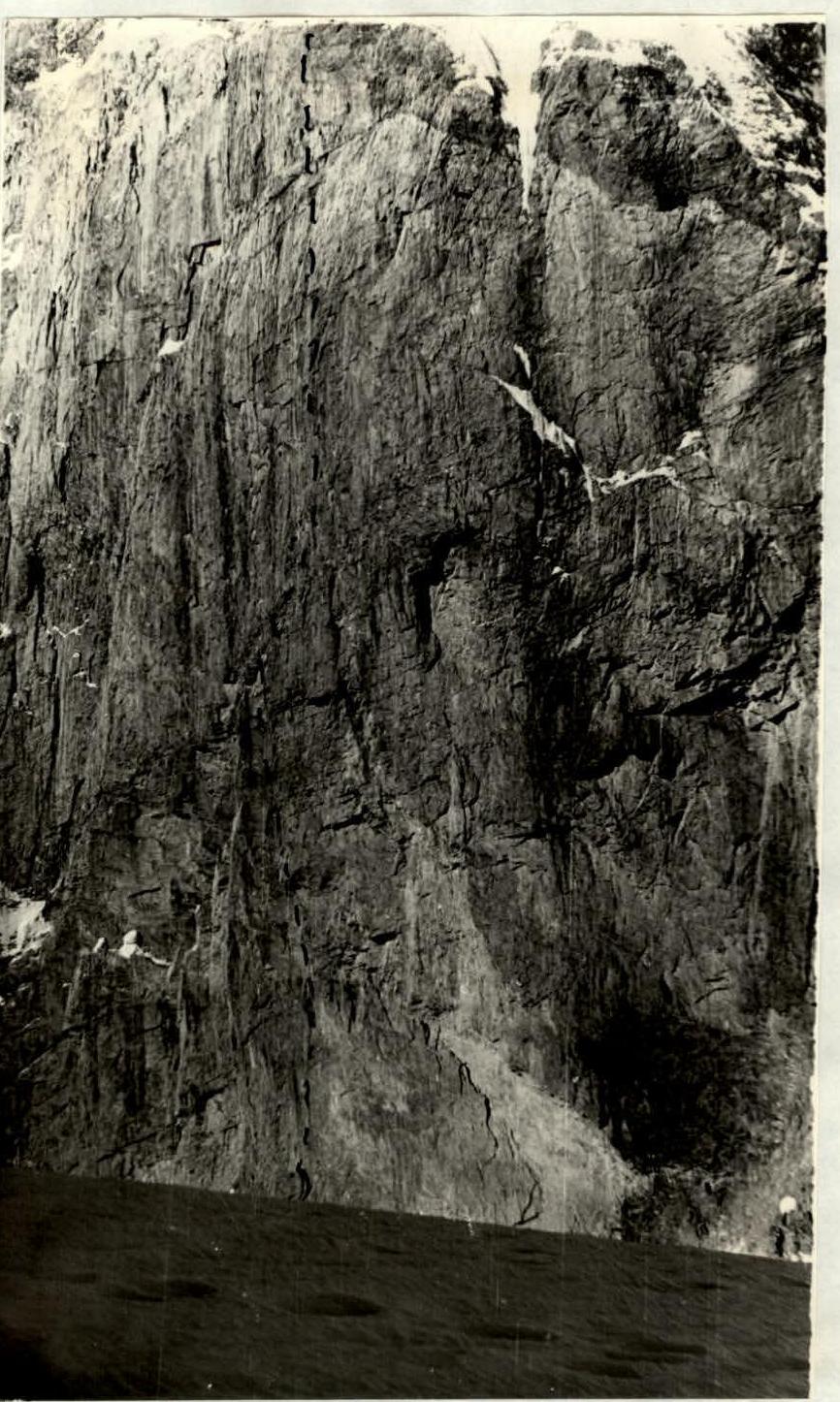 View from the Ushba Plateau of the central part of the wall.
 Lifting backpacks along the overhanging part of the wall. The backpack does not touch the wall. Section R8–R9.