-
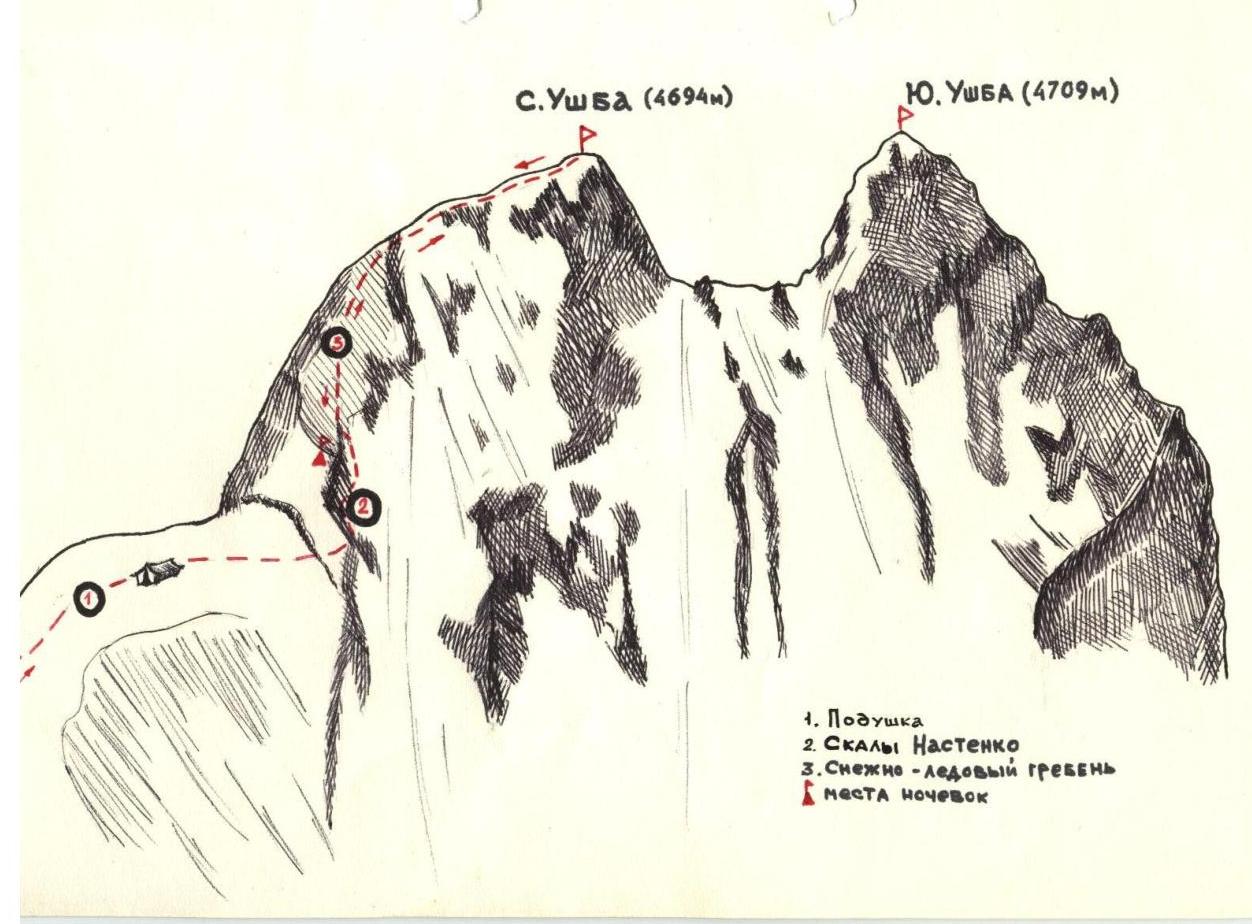
Pivushka
-
Nastenko Rocks
-
Snezhnaya — ice trainer — overnight stays
N.
NORTHERN UZHBA — 4B cat. climbing route. The height of the summit is 4694 m.
The Uzhba massif is located somewhat south of the Main Caucasian Range in Upper Svaneti.
To the northwest of Uzhba lies the Shkhielda summit massif, to the north — Shchurovskogo Peak, to the east — Chatyn-Tau.
From the col between the peaks of Northern and Southern Uzhba, the Gulski glacier descends to the north; to the east of Uzhba lies the western branch of the Chelot glacier, which descends from the Uzhba Plateau; to the west flows the Uzhba glacier.
Northern Uzhba has one ridge — the northern one, descending towards the Uzhba Plateau, via which the ascent from the plateau is made.
The southern ridge connects Northern Uzhba to the Southern one and is a col between these summits.
To the northeast and northwest, the slopes of the Uzhba massif drop steeply.
The first Soviet ascent was made in 1936 by comrades Kizel and Oleinikov from the Uzhba Plateau via the northern ridge.
The path from the Spartak base to the Uzhba Plateau (see description for Shchurovskogo Peak).
The path from the Uzhba Plateau to the summit initially leads to the "cushion" of Northern Uzhba. The ascent to it is made in crampons. Having passed the "cushion", the traverse of a very steep hundred-meter firn slope begins, with a transition across a bergschrund on it.
Having passed the crevasse, the ascent continues towards the Nastenko Rocks in the direction of a small notch. The passage of this section is done in crampons with belay via ice screws or ice axe.
There is a danger of an avalanche from the overhanging mossy snow cornice above.
Having ascended to the rocks, the climb goes through the broken rocks of "Nastenko" with belay on pitons (there is a small snow patch on the rocks).
One should ascend to the upper part of the rocks, where a spot for an overnight stay can be arranged.
Above the rocks, the path goes along a firn and ice slope for 50–60 m, 50–60 meters away from the cornice, to the ridge. On this section, the ascent is made in crampons with belay via ice axe or on ice screws.
Before reaching the ridge:
- the slope is very steep,
- several steps need to be cut.
Above, the ascent to the summit goes along the ridge; the ridge has three drops on its path.
To the northeast, enormous snow cornices overhang from the ridge; the slopes drop steeply all the way to the Uzhba Plateau.
The slopes towards the Uzhba glacier are also very steep. The ascent along the ridge is made all the time on its northwestern side. In places where ice is exposed from under the snow, step-cutting may be necessary. During the ascent, one should carefully watch out for heavily overhanging snow cornices and not approach the edge of them due to the danger of falling through.
The summit is a ridge with an overhanging snow cornice.
The cairn is located 10 meters below on the right side on stone slabs on the path to the col between Northern and Southern Uzhba.
The ascent from the Uzhba Plateau to the summit takes 10–11 hours; the descent takes 6–7 hours and is made to the plateau in one day, with the plan to start very early in the morning; depending on the snow and ice cover, the time may vary.
According to another variant, the time calculation may be as follows:
- 1st overnight stay on the Ihel'da Plateau (not mentioned in the initial description, possibly a different route or additional info),
- 2nd on the "Nastenko" rocks,
- 3rd during the descent from the summit on the Uzhba Plateau.
For the ascent, the following equipment is required:
- Crampons,
- Ice axe,
- Rope,
- Climbing hooks (2–3 pieces),
- Ice screws,
- Hammer,
- Warm clothing,
- Sleeping bags,
- (Extra) crampons (in a hurry),
- Goggles.
- HACCHIK (Gawain)
8 unnamed. Centrogeneзис. Umba.