Route Description
to the summit of "Bezыmannaya" via the southern ridge from the southwest or Gumači pass, category 2A
The summit "Bezыmannaya" is located in the upper Adyl-Su valley between the summits Gumači and Chetchat. The ridges of Bezыmannaya consist of simple destroyed rocks alternating with scree and individual snow-ice sections.
The described route (traverse) from southwest to northwest was completed on August 6, 1974, by a training and sports group of the All-Union School of Instructors of Mountaineering under the All-Union Central Council of Trade Unions in the following composition:
- I. Naydovich B.V. — leader.
-
- Starikov G.A.
-
- Sinelshchikov G.A.
The route is evaluated by the group as category 2A. From the "Elbrus" base camp, the path lies along the road to the "Jantugan" base camp, then along the trail on the left bank of the Adyl-Su River to a stone bridge, across which you should cross to its right bank. Further along the trail — to the "Green Hotel" clearing. From the "Elbrus" base camp — 3.5 hours.
From the "Green Hotel", go up along the ridge of the right-bank moraine of the Jan-Kuat glacier to the sites at its end ( bivouac "Sneznyy" or "Snowy").
There are two options for reaching the southern ridge of Bezыmannaya.
I. From the "Sneznyy" bivouac, exit onto the Jan-Kuat glacier and move up it towards the foot of the right southwest buttress of Bezыmannaya (photo #1, fig. #1).
Up the scree ridge separating the snowy slope, to the right of the buttress, ascend to the rocky saddle. Cairn. From the "Sneznyy" bivouac — 2 hours. From the saddle, 100 m up to the left along the ridge crest. It is better to bypass a small wall on the way to the left (photo #2).
Exit onto the main ridge to the left up a steep yellow inner corner- Couloir (25 m).
Further along the southwest ridge, the path leads to the southern summit of Bezыmannaya. Cairn. From the saddle — 1/2 hour.
II. From the "Sneznyy" bivouac, exit onto the Jan-Kuat glacier. Along it, up and around to the right the southern ridges of Bezыmannaya, then to the left, ascend to the Gumači pass.
From the pass, ascend to the left up the snowy slope and through the destroyed rocks onto the southern ridge of Bezыmannaya. Cairn. From the "Sneznyy" bivouac — 2.5–3 hours.
Along the destroyed rocks of the southern ridge, the path continues to the first gendarme. The first gendarme is bypassed to the right along a ledge (30 m) with belay through the outcrops. From the saddle along the sharp ridge — 15 m to the second big pre-summit gendarme, which is bypassed to the left.
First, you need to:
- descend down the sloping ledge (belay through the outcrops) to the snow-ice slope,
- then move along the "pocket" between the slope and the wall of the gendarme (10 m) to the beginning of the rusty-red ledge, which leads diagonally upwards to the gray-white rocks of the summit tower.
Movement with alternating belay through the outcrops! Gray-white rocks are strong and are overcome directly upwards (30 m) to exit onto the main ridge.
From here, bypassing the summit tower to the right along the ledges (40 m), — exit to the summit. From the southern summit — 2 hours.
Descent from Bezыmannaya is possible in two ways.
I. To the north — descend along the wide snowy ridge to the pass. From it, down to the right along the rocky-scree couloirs and the snowy slope onto the Gumači pass plateau, then ascend to the pass itself and descend onto the Jan-Kuat glacier.
II. From the summit, descend along the wide snowy ridge to the north to the pass (3). From it, down to the left, traversing the right rocky ridge, exit onto the far snowy slope (100–120 m). Along it, descend to the left through the bergschrund (snow bridges are possible) onto the plateau. Crossing the plateau, descend to the left and down, sticking to the right side of the glacier. Further, along the right-bank moraine down and, crossing the glacier, return to the "Sneznyy" bivouac.
Descent from the summit takes 2 hours. Total duration of the route from the "Sneznyy" bivouac — 6.5–7 hours. Recommended group size — 4–12 people.
Description compiled by: August 6, 1974
- Naydovich B.V.
- Starikov G.A.
Supplement: the route is comparable to similar ones:
- VNA-Tau (S. ridge) category 2A
- Sulakhat, traverse category 2A
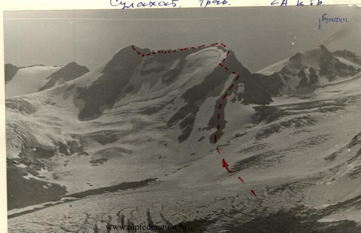 Photo #1
Bezыmannaya (along the southern ridge from southwest to northwest)
category 2A
 Fig. #1
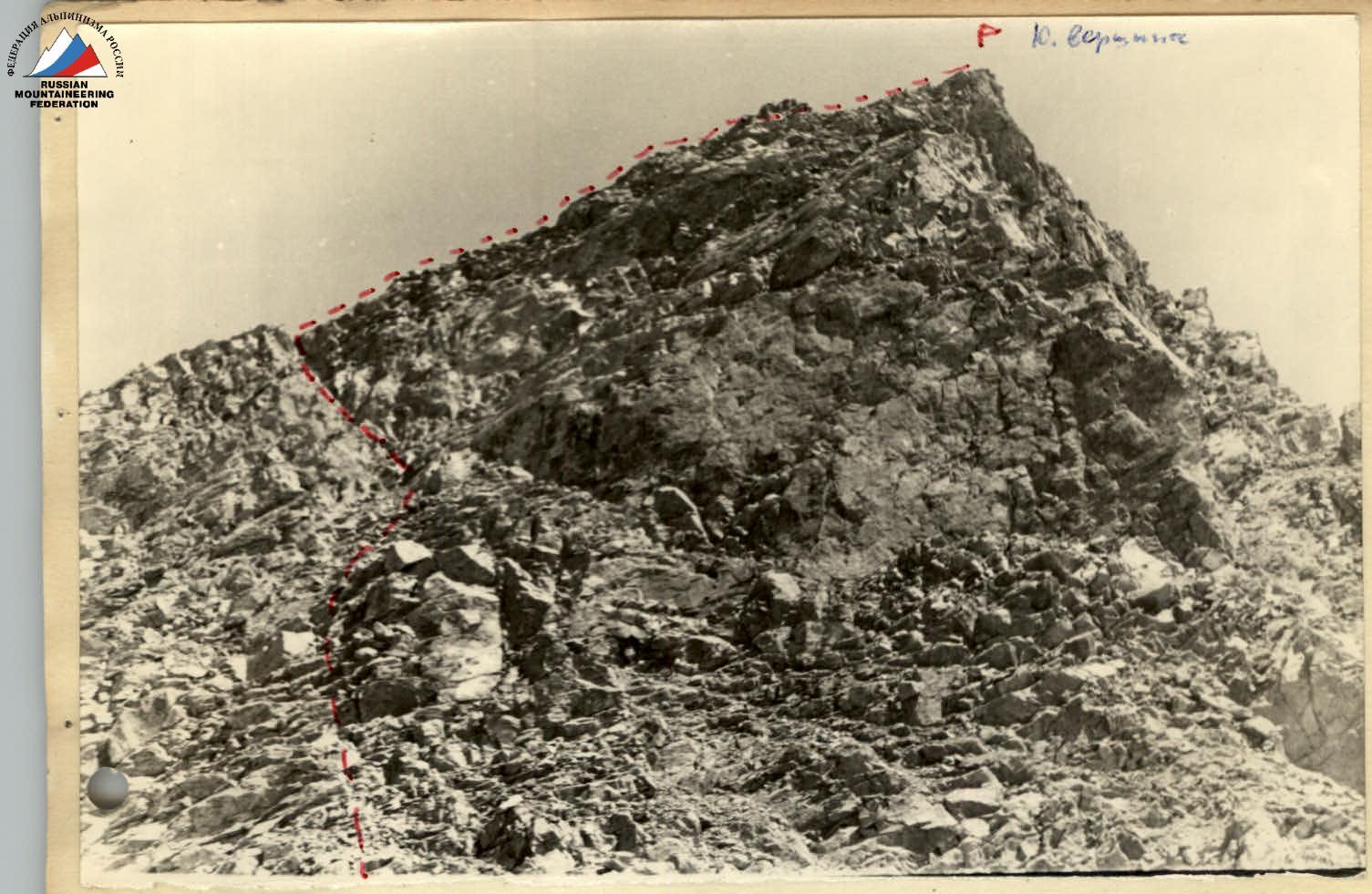 Photo #2
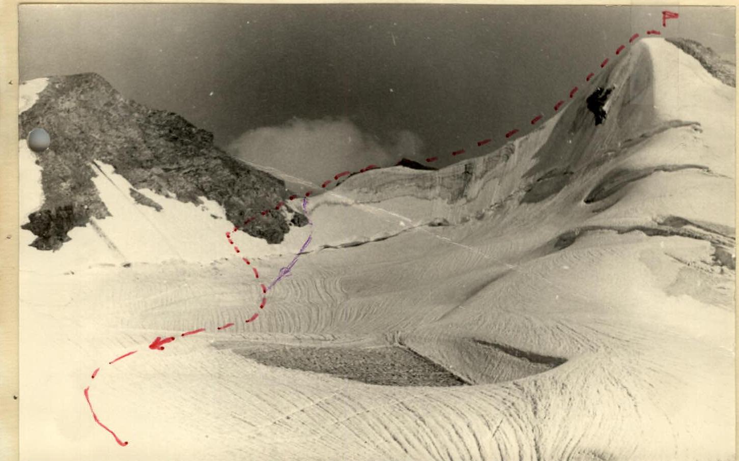 Photo #3