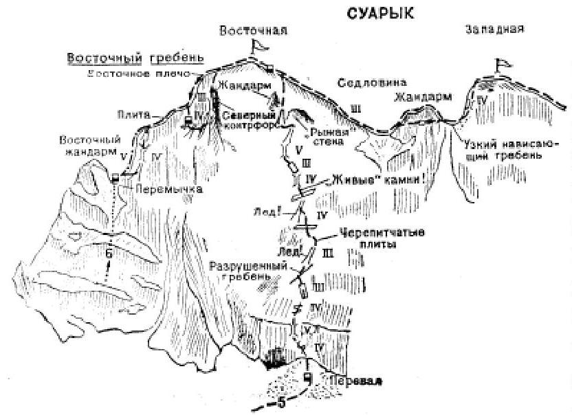
- Traverse of the Suaryk massif from east to west (P. Yakuts route, cat. 4A).
The path from the village of Verkhny Baksan to the initial bivouac on the platforms in the upper reaches of Zugully is described in route 4. From the platforms (a group of 4–8 people) ascent along grassy slopes to the right of the scree descending from the moraine rampart (rockfall along the scree!), and at the top exit to the moraine rampart. Further up along gentle snow-covered scree and simple rocks to a narrow (3–5 m wide) couloir-chimney descending from the col between the Eastern Gendarme and the ascent of the Eastern ridge of the Suaryk East summit. From the platforms 2.5–3 hours. From the scree straight up along the 120-meter couloir-chimney (rockfall, "live" stones, piton belays!). The couloir gradually narrows, its steepness increases, and in the upper part before exiting to the col platform, complex climbing requires piton belays. On the col, a cairn. From the scree 2.5–3 hours.
From the col, turn left and along simple ridge rocks ascend 20 m to below a sheer 30-meter wall. The wall can be climbed:
- to the right along heavily destroyed difficult rocks of the vertical 30-meter couloir, gradually turning into a chimney; from the chimney along a 2.5-meter overhanging wall and a simple 10–12-meter rocky groove ascent to the Eastern ridge above the wall (piton belays!);
- along difficult rocks of the wall 2.5–3 m straight up to a ledge and along it left-up; from the end of the ledge up the wall ascent to the Eastern ridge above the wall (piton belays!).
Further 50–60 m up along moderate ridge rocks with a 6-meter slab-like ascent (piton belays!) in the middle part. From the ridge, a 15-meter rappel to the right onto a platform. From the platform, traverse 35–40 m along scree under the ridge rocks with crossing a couloir descending from the ridge, and beyond it exit to a small counterfort. From it along moderate rocks descent to the scree of the main couloir and along scree (to the left) of the characteristic finger-like gendarme, then along simple rocks ascent to a chimney. Along difficult rocks of the chimney with a rock plug ascent to the northern counterfort. Along moderate rocks of the counterfort ascent 90–100 m to below a wall. Along the wall straight up to the eastern shoulder of the main ridge of the massif. From the shoulder along a gentle simple wide rocky ridge in 10–15 minutes ascent to the summit of Suaryk East. From the col below the Eastern gendarme 4.5–5 hours.
From the summit, descent along scree on the right side of the Western ridge. Before the col, exit to the ridge and along above-moderate ridge rocks descent 10–12 m to a snowy col between the summits of the massif. From the Eastern summit — 30 minutes. From the col, ascent along the wall of the gendarme to one-third of its height, then bypass it with a traverse 60 m to the right (belays!) with exit to a narrow overhanging rocky col below the Western summit. From the col along a 15-meter scree — exit to the base of the chimney of the rocky ascent of the Western summit. Along difficult rocks of the 8-meter chimney (piton belays, key point of the route!) straight up. From the chimney — ascent along a wide 15–18-meter ledge. From the end of the ledge exit left and behind the corner along a 4-meter wall ascent to the Western summit. From the col — 1.5–2 hours.
From the Western summit, descent 25 m along moderate rocks of the Western ridge, then along a 2-meter wall to scree, which after 25 m again ends in a wall. From the wall, rappel to the second scree. On the scree, a bivouac. From the bivouac on the scree, rappel 40 m to a ledge on the right side of the ridge. Along the ledge, traverse under the wall to the left, then ascent 40–50 m to the ridge. Descent can be made directly along the ridge, not along the walls of its right side. From here along simple ridge rocks 30-meter descent to the col below the 2nd gendarme of the Western ridge. From under the gendarme 30 m down to scree to the right of the ridge and along wide ledges, terraces, and moderate rocks (belays!) 100-meter bypass of the gendarme. Beyond it along a couloir ascent to the col below the 1st gendarme. From the Western summit 4–5 hours.
From the col along simple ridge rocks pass the 1st gendarme and exit behind it to the last col of the Western ridge. From here turn left and along a chimney, and then along a couloir descent to scree below the southern walls of the massif. Further along scree and grassy slopes descent to the platforms of the initial bivouac.
Duration of the route 3 days.
Special equipment for a group of 4 people:
- main rope — 2 × 40 m;
- auxiliary cord — 5 m;
- rock pitons — 8–10;
- rock hammers — 2;
- carabiners — 8–10;
- tent — 1.
Possible bivouac locations:
- on the col below the Eastern gendarme;
- on a ledge 15 m below the Eastern ridge (on its right side);
- 50–60 m above the first 30-meter wall;
- on the shoulder of the Eastern ridge;
- on the snowy col between the summits;
- on the summits;
- on all scree of the massif.
"Baksan valley", A. F. Naumov