
Passport
- Section number according to KMGV — 2010 — 2.4. Central Caucasus, mountain region — Prielbrusye, Terskol gorge, SE spur of Elbrus
- Names of peaks: Sarykolbashi-tersak (3776) — Sarykol (3700)
Route: traverse from south to north
- Category of complexity: 2B
- Character of the route — rock.
- Height difference of the route: 1376 m
- Length of the route: 3320 m
- Length of sections with the highest category of complexity:
1st cat. — 2 sections — 2300 m, 2nd cat. — 7 sections — 970 m, 3rd cat. — 0 sections — 0 m, 4th cat. — 1 section — 50 m, 5th cat. — 0 sections — 0 m, 6th cat. — 0 sections — 0 m.
- Average steepness: main part of the route — 75°.
entire route — 40°.
9. Pitons used:
Total used on the route:
- rock pitons — 12
- chocks — 32
- stationary pitons — 0
- ITO — 0
- removable pitons — 0
Left on the route: total — 2; including stationary pitons — 0.
- Departure on the route — 4:00, October 10, 2012
Reached the summit — 14:00, October 10, 2012. Returned to BL — 19:00, October 10, 2012
- Team's travel time: — 14 hours.
- Leader: N. Kirichenko (2nd sports category, Khabarovsk, DGUV).
Participants: V. Stepa (2nd sports category, Khabarovsk, DGUV), V. Trukhachov (2nd sports category, Khabarovsk, DGUV).
- Coach: Dusharin I. T.
Route description
The route "traverse Sarykolbashi-tersak — Sarykolbashi" is a typical training and sports rock route of 2B category, with a full set of natural obstacles corresponding to routes of this level, and a very difficult, albeit short, key section.
Approach
The ascent is made from the village of Terskol. Follow the dirt road to the corral near the mouth of the Sarykol stream. Then, along the Sarykol stream valley, ascend to the source of the stream, where the watercourse disappears in the talus. This is the starting point of the technical part of the route.
Technical part
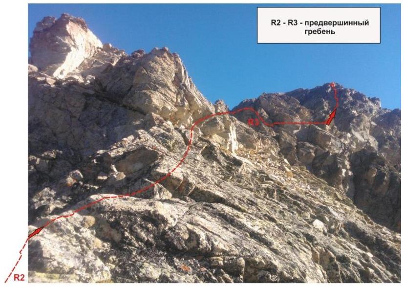
Climb the talus slope to the Soldatsky pass. On the pass, organize a rope team. To the right, ascend to the southern ridge of the Sarykolbashi-Tersak peak along the wall. (Key section of the route, 2A category) The wall has abundant relief for climbing and organizing intermediate belay points.
After passing the wall:
- exit to the rocky shoulder of the southern ridge;
- straightforward movement along the ridge to the summit tower.
Then, climb to the summit along a moderately steep wall.
From the Sarykolbashi-tersak summit:
- descend along the northern ridge to the saddle;
- move along the destroyed rock-and-talus ridge to the north (towards Elbrus);
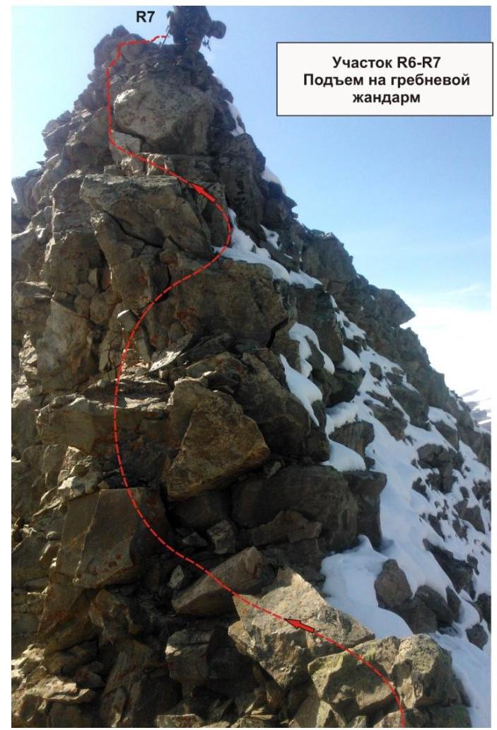
- approach the pronounced gendarme.
The gendarme's rocks are heavily destroyed (subjective rockfall danger!), so ascending and descending it requires careful passage.
After the gendarme:
- the ridge is composed of hard gray rocks;
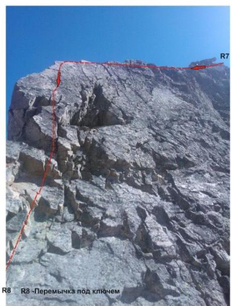
- transition from the ridge to a rocky drop;
- organization of a rappel to the rocky saddle under the key section.
Key section of the route: steep, sharp outer corner — "Knife".
- complicated climbing of the fourth category of complexity.
- requires scouting the path of movement upwards.
- the relief lures you to the left, but leads under the overhangs.
- the "Knife" is overcome head-on.
- there are convenient places for belay stations below and above.
- after passing the "Knife", move upwards along the destroyed rocky ridge to the summit.
The summit is clearly pronounced. The cairn is easily found. Descent from the summit: initially requires organizing two rappels along the northern ridge. The rocks are destroyed (objective rockfall danger!), so increased attention is required when organizing the descent. Then, move along the northern ridge to a wide talus saddle. From the saddle — two sports rappels down the slabs to the talus couloir. Descend along the talus couloir to the Sarykol stream, then along the stream valley to the corrals, and return to the village of Terskol via the dirt road.
Recommendations for the instructor
Due to the ease of orientation, the route can be recommended for both training and sports groups (SP-1, 2) and for independent sports groups of ranked climbers, conducting guided or training ascents, but the increased complexity of the key section should be taken into account. Time spent on the route for training and sports groups (SP-1, 2) — 12–14 hours.

Central Caucasus, Prielbrusye, Terskol gorge, Peaks Sarykolbashi-Tersak (3776), Sarykolbashi (3700). Route: "Traverse from south to north" 2B (rock) (approximate)
Table of natural obstacles on the route:
| Section | Length | Steepness | Character of relief | Cat. diff. | Number of Pitons/Chocks |
|---|---|---|---|---|---|
| APPROACH R0 — start of the route — start near the source of Sarykol stream | From the village of Terskol along the Terskol gorge to the start of the route — 1.5 hours. Of which — 1 hour along the valley (dirt road, trail), then along the talus slope of the couloir to the source of the Sarykol stream — 30 minutes. | ||||
| R0–R1 Ascent along the couloir to the Soldatsky pass (place of rope team organization) | 2000 | 15-30° | Talus | n/c, 1 | 0 / 0 |
| R1–R2 Ascent to the rocky shoulder of the southern ridge KEY SECTION OF THE ROUTE. | 70 | 55° | Dense rocks. Inclined wall | 2+ | Used: 0/8, left: 0/0 |
| R2–R3 Passage along the destroyed rocky ridge and approach under the summit tower. | 300 | 25° | Destroyed rocks, talus | 1 | Used: 0/0, left: 0/0 |
| R3–R4 Ascent to the summit | 150 | 45° | Inclined wall. | 2-, 2+ | Used: 0/0, left: 8/0 |
| R4–summit Sarykolbashi-tersak (3776) | Large talus area, allowing safe placement for two or more training and sports groups | ||||
| R4–R5 Descent from the summit along the northern ridge to the talus saddle. | 200 | 25° | Destroyed ridge | 2- | Used: 0/0, left: 0/0 |
| R5–R6 Passage along | 300 | 25-30° | Destroyed | 2- | Used: |
| destroyed ridge under the gendarme | ridge | 0/0, left: 0/0 | |||
| :--: | :--: | :--: | :--: | :--: | :--: |
| R6–R7 Ascent to the gendarme. | 80 | 55° | Destroyed ridge | 2+ | Used: 2/8, left: 0/0 |
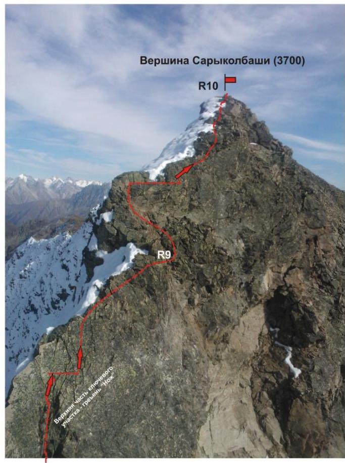
| R8–R9. KEY SECTION. Passage along the vertical ridge "Knife" | 120 | 55° | Inclined slab (at the end, rappel 50 m) | 2+ | Used: 4/0, left: 2/0 |
| R8–R9. KEY SECTION. Passage along the vertical ridge "Knife" | 50 | 70-75° | Sharp vertical ridge | 4- | Used: 6/8, left: 2/0 |
| R9–R10. Ascent to the summit along the destroyed ridge | 50 | 45° | Destroyed rocky ridge | 2- | Used: 0/0, left: 0/0 |
| R10 Summit Sarykolbashi (3700 m) | Pinnacle-shaped rocky tower. The top is heavily destroyed. | ||||
| DESCENT | Descent along the northern ridge (about 500 m) to a lowering (rappel possible — slope steepness more than 50°). Then, from the saddle, two sports rappels down the slabs to the talus couloir. On the talus, pack up the ropes and equipment. Then, descend along the talus couloir to the Sarykol stream, then to the Terskol river valley, and return to the village of Terskol via the dirt road, taking about four hours. |
Total:
Length of the route — 3320 meters. Average steepness — 40°, on the key section — 77°. Character of relief — rocky.
Sections:
- 1st cat. — 2 sections — 2300 meters
- 2nd cat. — 7 sections — 970 m
- 3rd cat. — 3 sections — 0 m
- 4th cat. — 1 section — 50 m
Used: pitons and chocks: 12 (32). Left: pitons and chocks: 2 (0)
Section R7–R9
Lower part of the descent from the gendarme — inclined slab with a triangular niche.
Above the niche on the ridge:
- belay station
- rappel station
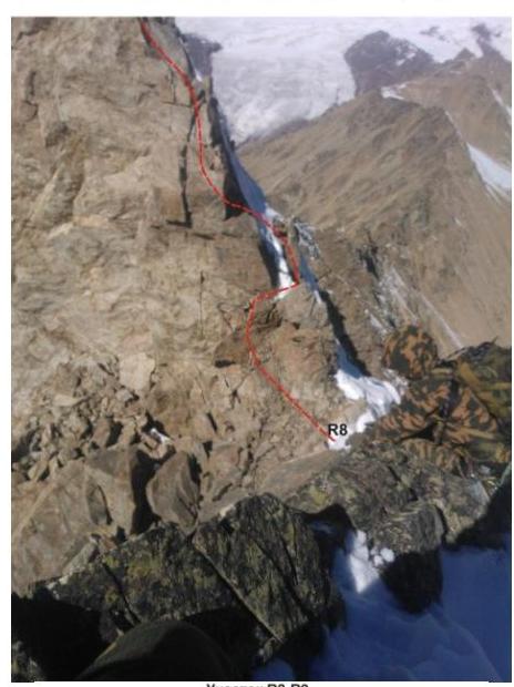
Section #49. Upper part of the key section — rocky ridge "Knife"

Section R9–R10
- Exit to the summit along the southern ridge
Comments
Sign in to leave a comment