Ascent Passport
I. Ascent class — rock 2. Ascent area — Central Caucasus, Main Ridge 3. Peak, its height and ascent route — p. Olympiycev (p. 3805), 3805 m, via the left buttress of the North face. 4. Presumed difficulty category — 3B 5. Route characteristics: height difference — 300 m average steepness — 40°, length of sections: — II — 200 m — III — 100 m — IV — 40 m — V — 80 m 6. Pitons hammered: for belay, for creating, etc. rock — 15 ice — bolts — 7. Number of climbing hours — 7 8. Number of nights and their characteristics — 0 9. Surname, name, patronymic of the leader and participants, their sports qualification: Rudenko Alexander Vasilyevich, 1st sports category Lapteva Tamara Vladimirovna, CMS. Puzin Vyacheslav Lvovich, 1st sports category. Kamaeva Silima Ibragimovna, 3rd sports category. 10. Team coach — Chernyshev Yu.B., CMS. 11. Date of departure and return — July 28, 1980
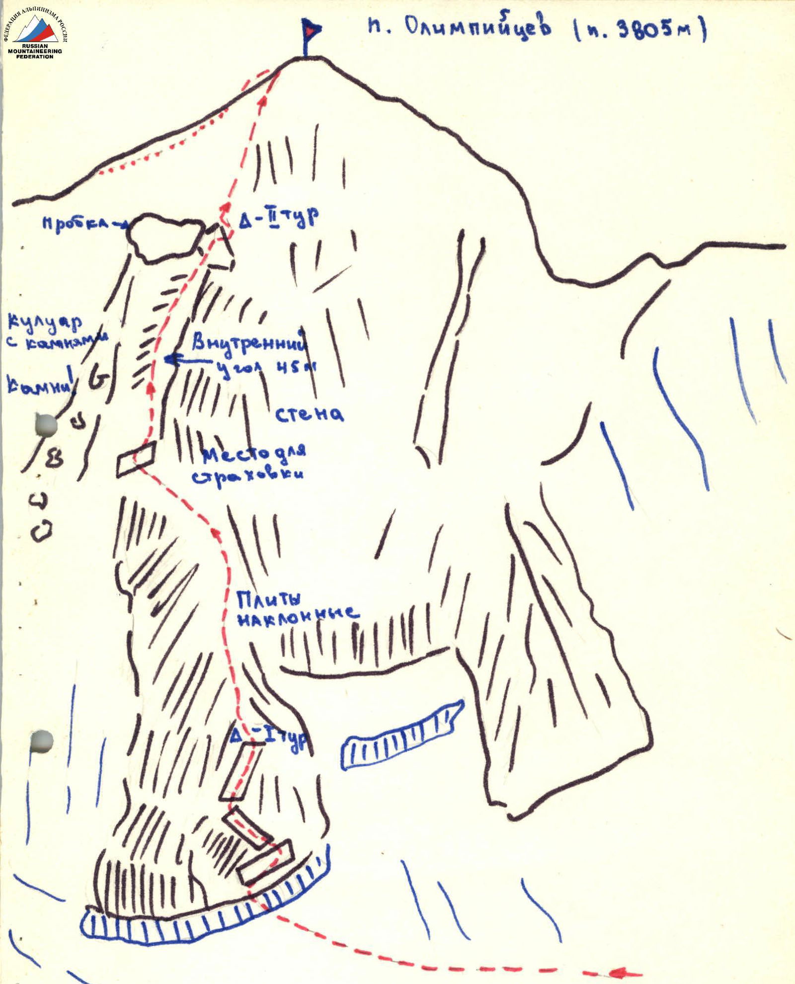
Description of the route to p. Olimpiets (p. 3805) via the left buttress of the North face, approximately 3B difficulty category.
From the overnight stay on the terminal moraine of the V. Donguzorun glacier, bypassing the stream in the upper part, exit to the snow-ice plateau under p. Olimpiets (p. 3805). From the overnight stay 2–2.5 hours.
Approach the lower rocks of the left buttress via the plateau and ascend 40–50 m to the talus shelf. On the shelf is a control cairn.
From the cairn: — ascend to the right, — exit to the talus ridge.
Along the ridge, bypassing the gendarmes to the left and right, approach the wall of the summit tower. Further, up and left along the rocks of medium difficulty under the start of the large internal angle with a plug at the top (pitons for belay).
Up the internal angle under the plug, then exit to the right along a 2–3 m wall to an inclined shelf. (Key location, piton belay, difficult climbing 40 m).
On the shelf is the second control cairn.
From the shelf, up and right along the rocks of medium difficulty 60–80 m to the summit. From the control cairn 5–6 hours.
The route has many loose rocks. Exercise special caution on internal angles.
The descent goes: — to the Becha pass, — or along the western ridge with a descent to the talus. (2A difficulty category)
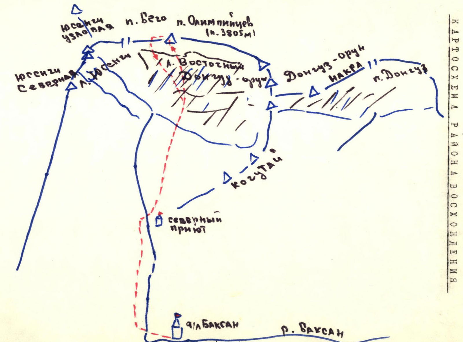
Approach to the route description
From the "Baksan" tourist center, cross the Yusengi River and immediately start ascending along the pack trail in the forest along the left bank of the Yusengi River, leading to p. Bicho. Then follow the trail on the grassy slopes to the Northern Shelter. Near the shelter, cross the river and along the slopes, and then the meadows, reach the overnight stay on the terminal moraine of the V. Donguzorun glacier. From the overnight stay, bypassing the stream in the upper part, exit to the snow-ice plateau under p. Olimpiets (p. 3805 m).

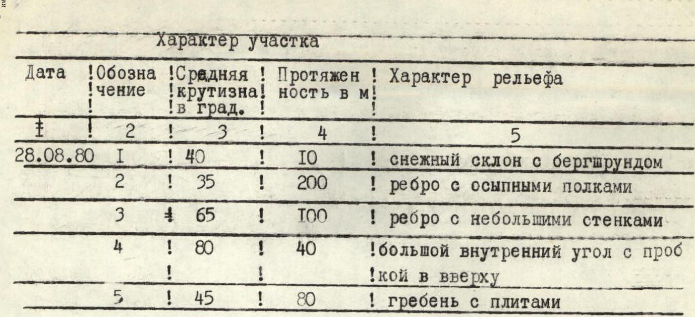
Section characteristics
| Date | Designation | Average steepness in degrees | Length in m | Terrain characteristics |
|---|---|---|---|---|
| 28.08.80 | R1 | 40° | 10 | snow slope with a bergschrund |
| R2 | 35° | 200 | edge with talus shelves | |
| R3 | 65° | 100 | edge with small walls | |
| R4 | 80° | 40 | large internal angle with a plug at the top | |
| R5 | 45° | 80 | ridge with slabs |
Pitons
| Designation | Difficulty | Condition | Weather conditions | Rock | Ice | Bolt |
|---|---|---|---|---|---|---|
| R1 | 2 | bergschrund in a broken state | satisfactory | – | – | – |
| R2 | 2 | rocks moderately fractured | – | – | – | – |
| R3 | 4 | monolith | – | 10 (ledges) | – | – |
| R4 | 5 | rocks moderately fractured | – | 5 | – | – |
| R5 | 3 | monolith | – | (ledges) | – | – |