2. 4.132
REPORT
on the ascent to the peak MNR south-west via the eastern edge from the Kurmy glacier (first ascent, estimated cat. diff. 4A), made by the group of the tourist center “Adyl-Su” on July 6, 1975.
To the CKFA for clarification of the category of difficulty (route No. 184 according to the KTMGВ, cat. diff. 3B).
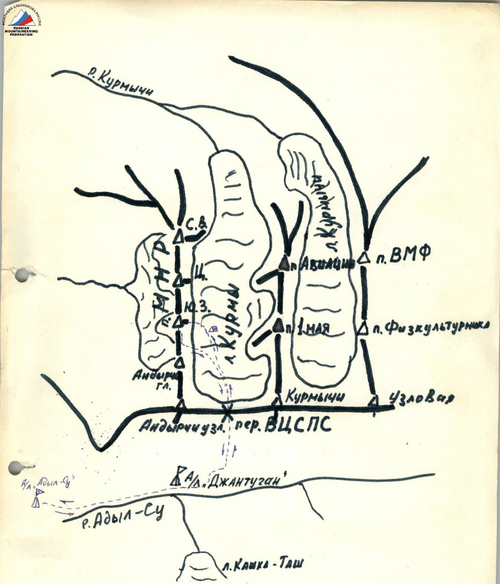
Map of the ascent area.
DESCRIPTION OF THE APPROACH TO THE ROUTE
Drive along the road up the Adyl-Su gorge to the “Adyl-Su” hostel of the USSR Ministry of Defense. From the hostel, follow the trail first along steep grassy slopes, and then along the talus to climb to the VTsSPS pass. From the hostel, it takes 3–5 hours.
From the pass, descend along the talus slopes to the plateau of the Kurmy glacier below the south-western peak of MNR. From the pass, it takes 30 minutes. Camp on the plateau or on the talus areas below the VTsSPS pass.
TABLE OF ROUTE CHARACTERISTICS
| Date | Designation | Average steepness | Length | Terrain characteristics | Difficulty | Condition | Rock | Ice | Mud |
|---|---|---|---|---|---|---|---|---|---|
| 6.7. 1975 | 1. | 60° | 60 m | internal angle | 4 | monolith | 3 | - | - |
| 2. | 30° | 15 m | slope | 3 | crumbly | - | - | - | |
| 3. | 65° | 25 m | chimney, slab | 4 | monolith | 2 | - | - | |
| 4. | 50° | 20 m | slope | 2 | crumbly | - | - | - | |
| 5. | 70° | 8 m | wall | 4 | monolith | 1 | - | - | |
| 6. | 55° | 40 m | slabs | 4 | monolith | 2 | - | - | |
| 7. | traverse | 7 m | edge | 5 | monolith | 1/1 ATO | - | - | |
| 8. | 70° | 30 m | wall | 5 | monolith | 3 | - | - | |
| 9. | 60° | 20 m | wall | 4 | monolith | 1 | - | - | |
| 10. | 75° | 15 m | crack | 5 | monolith | 1 | - | - | |
| 11. | 70° | 5 m | internal angle | 5 | monolith | 1/1 ATO | - | - | |
| 12. | 45° traverse | 30 m | slabs | 4 | monolith | 2 | - | - | |
| 13. | 75°–80° | 40 m | wall | 5 | monolith | 3/2 ATO | - | - |
Pitons hammered: rock — 24, including for ATO — 4. Climbing time: 5.5 hours.
ROUTE PROGRESSION
From the overnight stay on the Kurmy glacier plateau, ascend the wide talus couloir between the peaks Andyrchi and MNR south-west to a standalone rock "tooth" in the couloir. From it, move right along a 60-meter internal angle (moderate difficulty rocks, steepness 60°) to reach the eastern edge of the peak MNR south-west (R1), with a control cairn on the ledge of the edge.
Then, bypassing the wall on the right, exit via easy rocks to below a chimney (R2). Continue along the rock wall to the right of the chimney or via the chimney, then along a slab with a ledge and easy rocks to reach a wide ledge (R3). From the 1st control cairn, it is 40 m. From the ledge, move left and upwards along easy rocks for 20 m (R4) to below an 8-meter rock wall with a steepness of 70°. Climb the wall (R5) straight up to reach slab-like rocks leading to a saddle between a gendarme and the summit tower (40 m, 55° – R6). On the saddle, in a cleft, is the 2nd control cairn.
From here, with difficult climbing using artificial support (ladder, piton), traverse left behind the rock edge (R7) and move to the southern wall of the summit tower. Then, climb up complex rocks with a steepness of 70° for 30 m to a small ledge (R8). From the ledge, climb straight up along steep (60°) rocks with good holds for 20 m (R9) to below an overhanging rusty wall.
The overhanging section is bypassed on the left via a crack with free climbing (15 m, 75° – R10). Then, climb up along an internal angle (5 m, 70°, R11), followed by a short traverse to the right and upwards to a small ledge (30 m, R12).
From the ledge, climb straight up along very difficult rocks using artificial support for 40 m with a steepness of 75–80° to reach the summit of peak MNR south-west. From the overnight stay on the Kurmy glacier, it takes 5–7 hours to complete the route. Descent from the summit is via a route of category 2B difficulty.
There is no water or snow on the route. Special equipment for a group of 6 people:
- main rope 3 × 40 m
- expendable cordelette 5 m
- rock pitons 15 pcs. (including 5 channel pitons)
- carabiners 12 pcs.
- ladders — 2 pcs.
- rock hammers 2 pcs.
There are no convenient places for camping on the route.