Ascent Passport
Ascent Category — Rock Climbing
ASCENT AREA — CENTRAL CAUCASUS, PRIELBRUSIE, MONGOLIAN PEOPLE'S REPUBLIC PEAK NORTH-EAST via the South Ridge. Estimated category: 3B. Route characteristics: height difference — 530 m, average steepness — 45°, section lengths: I — 70 m, II — 150 m, III — 440 m, IV — 60 m. Pitons hammered on the route: for belay, for creating intermediate belay points: rock — 17, ice — , bolted — . Travel time — 8 hours. Number of overnight stays and their characteristics: none. Names and patronyms of the leader and participants: OSIPOV OLEG FYODOROVICH — CMS, leader; SALAZKO MIKHAIL NIKOLAEVICH — 1st category, participant; LAVROV NIKOLAI VLADIMIROVICH — 2nd category, observer; SNEZHKO YURIY VASIL'EVICH — 3rd category, observer. Team coach: Head of the training department at Adyl-su tourist center, senior instructor, Master of Sports of the USSR KUSSEL-MOROZ N.A. The ascent was made on August 14, 1978.
Brief Route Description
From Adyl-su tourist center, descend by road to the confluence of the Kurmy River and the Baksan River. Then ascend through the Kurmy gorge to the left (in the direction of travel) of the waterfall. Continue on the trail to the sheepfold on the moraine ridge.
Then:
- onto the Kurmy glacier, staying on the right side
- to the rocky shoulder below the MPR Peak North-East.
The shoulder serves as the initial bivouac. From the Baksan River — 5–6 hours.
From the shoulder, ascend the glacier to the couloir separating MPR Peak Central and MPR Peak North-East. Along the ledges on the left side of the south ridge of MPR Peak North-East, ascend along the ridge for 60 m. Then ascend 40 m to the ridge. Further along the ridge, after 80 m — a 10-meter wall (1st control cairn). The wall is overcome directly or on its left part.
Further along the ridge, after passing a 5-meter internal corner, exit under a 20-meter wall with a crack (key location of the route). Ascend on its left edge or through the crack.
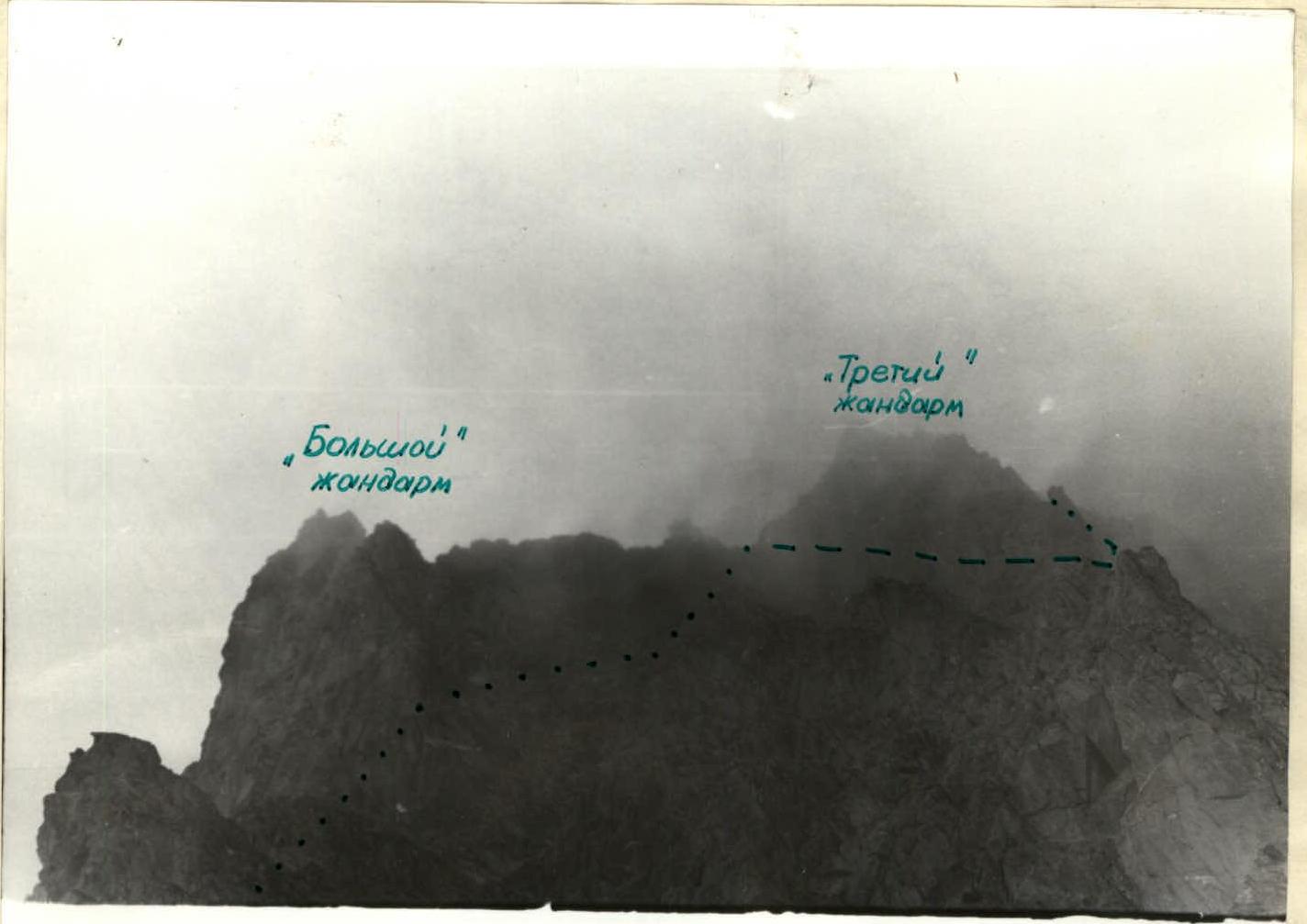
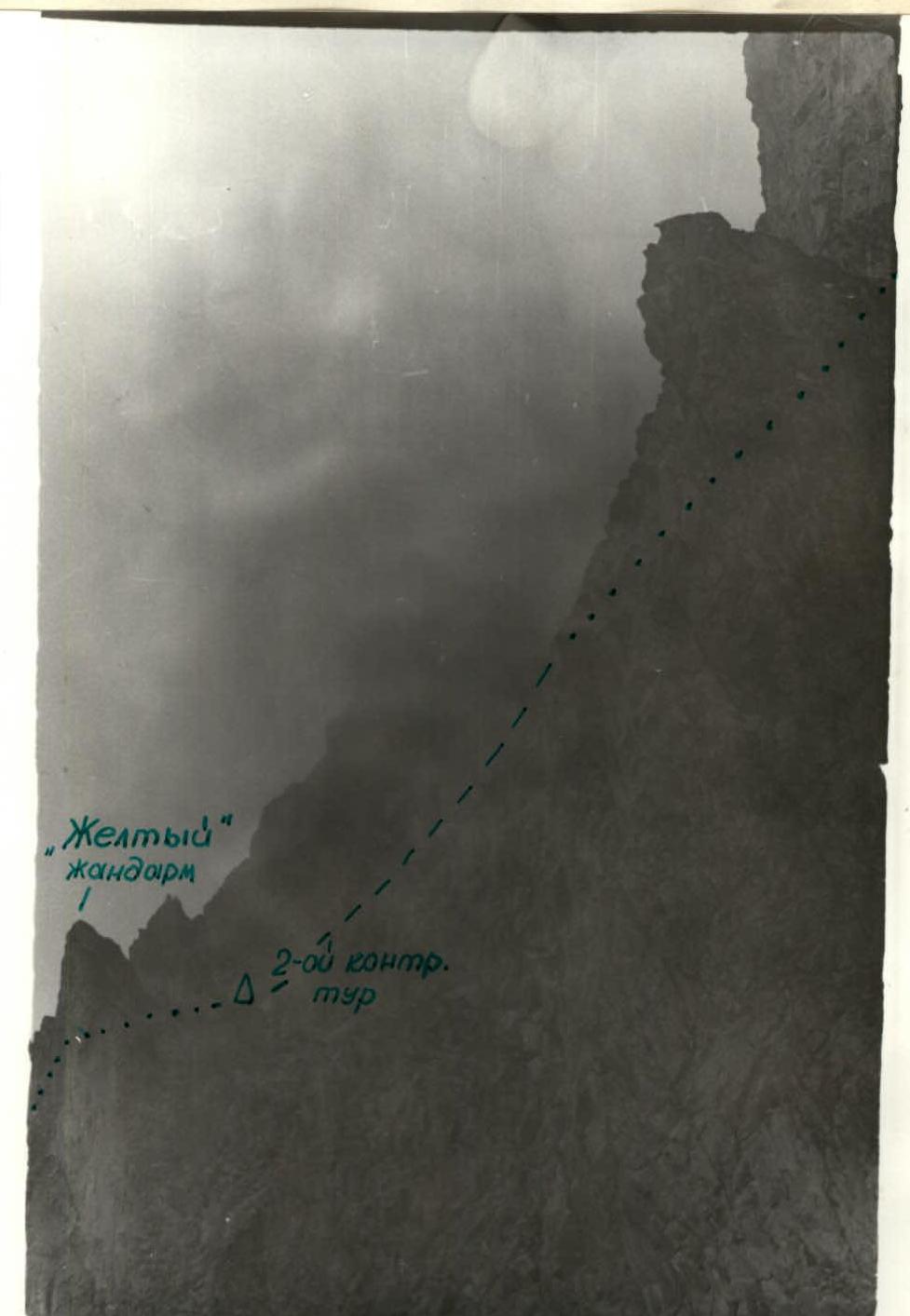
- The "Yellow Gendarme" after the wall is bypassed on the left.
- On the ridge saddle behind it — 2nd control cairn.
- Then ascend along the ridge from right to left, bypassing the "Big Gendarme" on the left and exiting onto the ridge.
- The third gendarme is overcome directly or bypassed on the right.
Beyond it — platforms from which ascend along the ridge to an internal corner leading to the pre-summit ridge. Further ascend along the ridge to the summit.
From the initial bivouac — 7–9 hours. Descent from the summit follows the 1B category route to the Kurmy glacier.
Special equipment for 4 people:
- Main rope — 2×40 m
- Rock hammer — 2 pcs.
- Carabiners — 8 pcs.
- Rock pitons — 10 pcs.
Section Characteristics and Pitons
| Date | Designation | Avg. Steepness | Length | Relief | Difficulty | Weather Cond. | Rock | Ice | Bolted |
|---|---|---|---|---|---|---|---|---|---|
| August 14, 1978 | R0 | 10° | 20 m | Snow | 1 | Snowy, bad vis. | — | — | — |
| R1 | 20° | 50 m | Ledges | 2 | Monolithic | — | — | — | |
| R2 | 75° | 40 m | Int. corner | 3 | Monolithic | 2 | — | — | |
| R3 | 30° | 80 m | Ridge | 3 | Fragmented | 1 | — | — | |
| R4 | 80° | 10 m | Wall | 4 | Monolithic | 2 | — | — | |
| R5 | 45° | 60 m | Ridge | 3 | Monolithic | 1 | — | — | |
| R6 | 75° | 20 m | Wall | 4 | Monolithic | 4 | — | — | |
| R7 | 10° | 20 m | Rocks | 1 | Fragmented | — | — | — | |
| R8 | 0° | 40 m | Slabs | 3 | Monolithic | 1 | — | — | |
| R9 | 40° | 100 m | Ridge | 3 | Monolithic | — | — | — | |
| R10 | 5° | 50 m | Ledges | 3 | Fragmented | 2 | — | — | |
| R11 | 20° | 20 m | Rocks | 2 | Fragmented | — | — | — | |
| R12 | 5° | 70 m | Ledges | 3 | Monolithic | — | — | — | |
| R13 | 30° | 30 m | Rocks | 1 | Monolithic | — | — | — | |
| R14 | 30° | 40 m | Rocks | 2 | Monolithic | — | — | — | |
| R15 | 60° | 30 m | Int. corner | 4 | Monolithic | 2 | — | — | |
| R16 | 10° | 70 m | Ridge | 2 | Monolithic | — | — | — | |
| R17 | 45° | 30 m | Rocks | 3 | Monolithic | 2 | — | — |
Copy
Protocol of the разбор of the ascent to MPR Peak North-East via the South Ridge, 3B category (approximately), first ascent by a sports group of instructors from Adyl-su tourist center led by Osipov O.F. on August 14, 1978.
Present: ascent participants Osipov O.F., Salazko M.N.; observers Lavrov N.V., Snezhko Yu.V.; head of training department Kusel-Moroz N.A.; senior instructor Kisel' V.V.; head of rescue service Shupilo N.L.
Presentations: leader Osipov O.F.
From the bivouac on the "sheepfold clearing" (in the area of the Jantugan tourist center) departed on August 13 at 10:00 and, crossing the VTsSPS pass, stopped on the "Green shoulder" of the Kurmy glacier moraine after 5 hours, where a bivouac was set up. The departure was planned for 5:00 am on August 14 but was delayed due to limited visibility and took place at 7:30. Reached the route at 8:00.
After reaching the ridge and walking 80 m along it, made the 1st control cairn below the wall. Further movement was mainly with alternating belay. The 2nd control cairn was made on the ridge saddle behind the "Yellow Gendarme", before which a 20-meter wall (key location of the route) was overcome. Reached the summit at 13:00. Descended via the 1B category couloir and were back at the initial bivouac in 40 minutes. The route corresponds to the 3B category. Weather during the ascent was cloudy, rocks were wet, which somewhat complicated the passage.
Salazko M.N. The route is well visible from the Kurmy glacier; the ridge is quite steep, requiring piton belay in many places when overcoming walls. The route is well-defined, logical, and corresponds to the 3B category. It is desirable to have footwear with a rubber protector on the route. Was satisfied with the partner in the rope team; belay was reliable throughout the entire route.
Questions to the climbers:
- "Do you recommend this route for lower-category teams?"
- Answer: "Yes, for training groups of the IV stage".
- "Is it possible to maintain belay on the route?"
- Answer: "The ridge nature of the route and the presence of crevices on wall sections allow for reliable belay to be organized throughout the entire route".
Head of training department N.A. Kusel-Moroz: leadership and participation in the first ascent are acknowledged.
Debriefing led by N.A. Kusel-Moroz
Secretary N. Lavrov
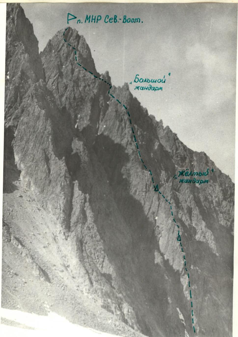
First Ascent Route

First Ascent Route (View towards VTsSPS Pass)
First Ascent Route (View towards VTsSPS Pass)
— 14 —