Ascent Passport
- Area 2.4, Caucasus, from Chiperazau Pass to Gumači peak, Ullukhurzuk gorge, southwestern spur of Mt. Elbrus.
- Kyukyurtlyu (Kyukyurtlyu–Kolbashi) 4639 m, via the center of the Western wall.
- Proposed category: 6B, first ascent.
- Route type: rock.
- Route elevation gain: 590 m, route length: 800 m, wall height: 470 m, wall section length: 515 m, section lengths by category: I - 150 m, II - 60 m, III - 70 m, IV - 80 m, V - 145 m (95 m on artificial anchors), VI - 390 m (all on artificial anchors); total artificial anchors: 390 m, difficulty: A1 - 35 m, A2 - 265 m, A3 - 90 m, average wall slope: 83°, overall route slope: 65°.
- Anchors left on the route:
total — 48
including:
- rock anchors — 14
- bolt anchors — 34 Also, втулок from "spits" left — 18 Insurance points used: total/including for artificial anchors — 238/188
- rock anchors — 84/69
- chocks — 62/55
- bolt anchors — 88/64
including:
- permanent — 52/28 including previously installed — 14
- removable — 36/36
- ice anchors — 4 Artificial anchors created on skyhooks, anchors, fifas — 251 Total artificial anchors used — 439
- Team's total climbing hours — 157.5 days — 20 Including "first" on terrain: hours — 94.5 days — 19
- Team leader:
Grigorov Andrey Vladimirovich (Saratov) — CMS
Team members:
- Goryaev Anatoliy Erdnigorayevich (Makhachkala) — MS
- Dorro Konstantin Eduardovich (Makhachkala) — MS
- Tabakov Sergey Vladimirovich (Saratov) — CMS
- Zinoviev Mikhail Ivanovich (Saratov) — CMS
- Bibin Oleg Yuryevich (Saratov) — 1st sports category
- Senior coach: Murtazaliev Ziyabudin Murtazalievich (Makhachkala) Coach: Serdyukov Ivan Ivanovich (Elbrus settlement)
- Team arrival at Shkhelda base camp — January 22, 2003 Arrival at base camp and start of approach processing — February 4, 2003 Start of route work — February 7, 2003 Summit ascent — February 26, 2003 Descent to Khurzuk village — March 1, 2003
- Team of Dagestan Republican Search and Rescue Service, EMERCOM of Russia (Saratov and Makhachkala team).
Kyukyurtlyu 4639 m
 General photo of the peak.
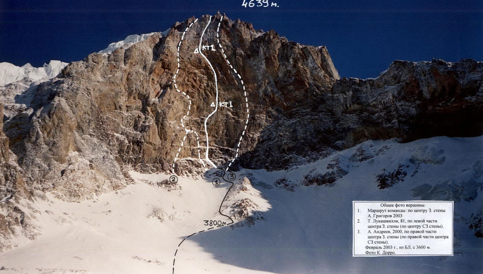
- Team's route: via the center of the Western wall, A. Grigorov, 2003.
- T. Lukashvilli, 1981, via the left part of the center of the Western wall.
- A. Andreev, 2000, via the right part of the center of the Western wall. February 2003, from base camp at 3600 m. Photo by K. Dorro.
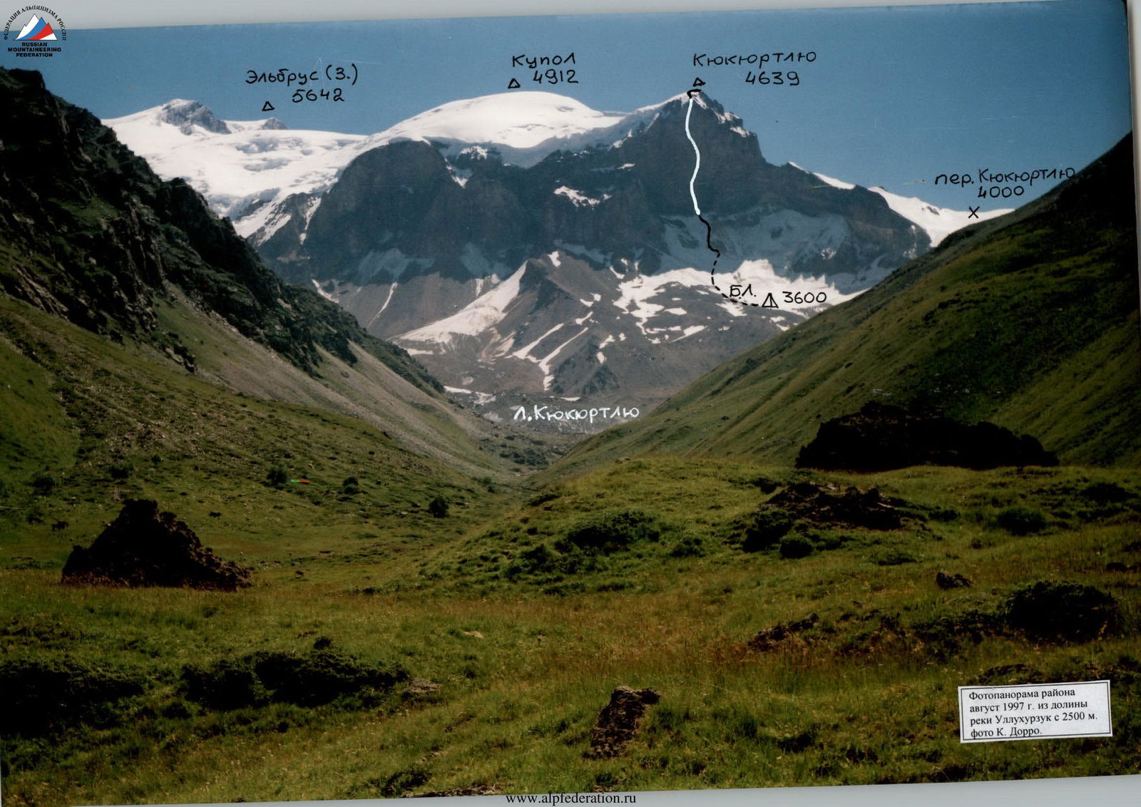 Panorama of the area, August 1997, from the Ullukhurzuk river valley at 2500 m. Photo by K. Dorro.
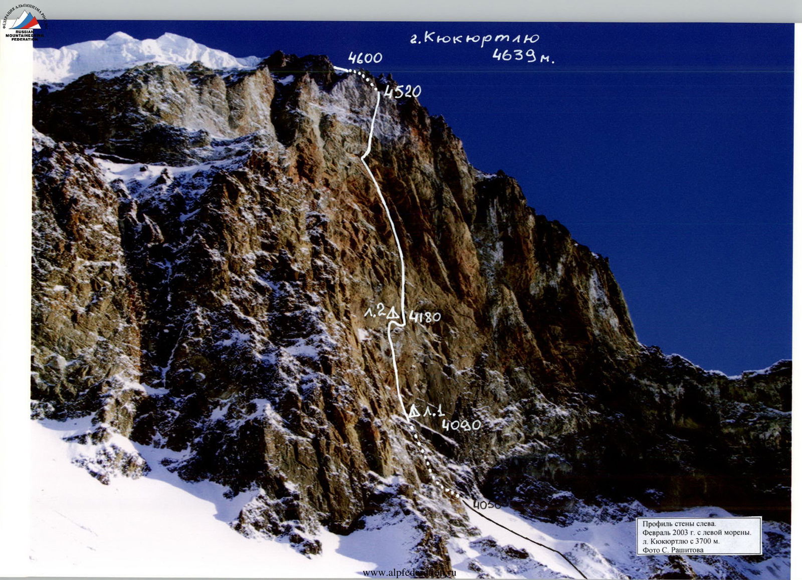 Profile of the wall from the left. February 2003 from the left moraine of Kyukyurtlyu at 3700 m. Photo by S. Rashitov.
Overview of the Ascent Area
The Kyukyurtlyu peak is located in the southwestern spur of Elbrus, 4.5 km from the Western summit. The peak is situated within the Karachay-Cherkess Republic, Russian Federation. Although it is part of the Elbrus massif, it is relatively remote from the usual approaches, especially the Western wall. The approach to the wall from the Baksan valley via the Khotyutau and Kyukyurtlyu passes takes about two days, but cargo transportation poses a challenge. Access from Karachay-Cherkessia: from Karachaevsk (1000 m) to Khurzuk village (1450 m) — 60 km along the Kuban river valley (Ullu-Kam), then along the Ullukhurzuk river valley (right tributary) on a dirt road to the confluence of Ullukhurzuk and Bitiktebe (1850 m) via numerous wooden bridges. From the confluence, the road turns right along the left bank of Ullukhurzuk to the last Karachay koš (15 km). The road after the confluence is very poor. The koš has a clearing, water, and forest (2300 m). Further up the gorge to the left turn (2500 m), Kyukyurtlyu and Elbrus come into view (2–2.5 hours); in winter, a "Buran" snowmobile can reach this point. Then, along the valley to the tongue of the Kyukyurtlyu glacier and up its left moraine to flat areas in the moraine "pocket" (3000 m) (2–2.5 hours). From the "pocket," up the moraine to the Western wall, where it becomes less steep, before the ice slope, near large rocks — the base camp location (3600 m) (2–2.5 hours). With a helicopter drop-off, it's possible to land on a hill slightly to the left and above the base camp. The elevation gain to the wall is about 450–500 meters. One must traverse a firn slope into a couloir, with the slope's steepness increasing from 10° to 45–50° (under the wall). Depending on the slope's condition, insurance and rope installation may be necessary. The team installed 400 m of ropes to R0 (ice processing and cargo transportation, February 4–6, 2003). The slope has narrow crevices and a bergschrund; movement in a rope team may be necessary. The route begins at the upper point of an arcuate ledge, at the start of a characteristic internal corner, at 4050 m, 3 hours from the base camp.
The peak is a small rise on the southwestern spur of Elbrus's Western summit. It drops away in walls to the south and west. The exposed wall has a western aspect (erroneously classified as northwest), but due to its great steepness and the right, overhanging part having a north-northwest aspect, the sun reaches the wall after 14:00. The wall's steepness results in water scarcity, with snow remaining only on the lower wall's ledges. The area is known for unstable and harsh weather; Elbrus's vast ice fields cool the air, often bringing cloud cover and snow in the afternoon. The Western wall of Kyukyurtlyu is the first to encounter moist air masses from the Black Sea, leading to frequent strong, humid winds. The ascent is complicated by partially destroyed rocks, especially in the upper wall ("gray" zone). The wall is composed of volcanic, mainly tuff, rocks. The ascent route is rock climbing, but the approach involves ice and, on the "roof," ice couloirs, requiring an ice climbing kit. One of the wall's features is its extreme steepness. A letter from the Institute of Geography, USSR Academy of Sciences, No. 13203, dated October 30, 1981, appended to V. Boyko's report (SKA-15, SKVO), indicates the wall's average steepness is 83° from the 4050 m mark to 4480 m. The Lukashvilli route exits slightly to the right, with a height gain of about 450 m. The route taken by the team has an even greater height gain (the largest on the wall) — approximately 470 m. Despite the relatively small height gain, routes on the Western wall are likely the most challenging in the Caucasus and Russia, both technically and tactically.
Factors making routes on the Western wall rarely visited include the area's remoteness, lack of reliable communication (including mobile phones), and harsh weather conditions (three team members suffered frostbite during the ascent). The significant height of the route's start, severe weather, and psychological strain due to the wall's difficulty contribute to its rarity. There have been incidents on the Western wall, including fatalities. The route by R. Giutashvilli (1974) has apparently only been climbed by the first ascendants, as has A. Andreev's route (2000); there have been eight ascents of T. Lukashvilli's route (1981).
The ascent is further complicated by the lack of a straightforward descent. A classic descent involves ascending to the summit of the southwestern spur's dome (4912 m) and then following the ridge to either the Big Azau glacier and down to the Baksan valley or through the Khotyutau pass (3546 m) into the Kuban river valley to Voroshilovsky koš. The team descended via their ascent route, having fixed ropes from 3800 m to 4600 m (1050 m of ropes), which were later removed. The EMERCOM of Russia provided invaluable assistance in ensuring the team's safety, cargo transportation, and evacuation.
Karachay-Cherkess Republican PSS: Head — Tsipkovsky Alexander Pavlovich, Deputy Head — Laipanov Alexander Khuseinovich Cherkessk, Lenin Ave. 272 "A" Tel. (87822) 6-74-60, 6-73-61 (operational duty officer). Operating on the 1st EMERCOM channel (164.400 MHz).
Elbrus Territorial PSS: Head — Tilov Boris Osmanovich, Deputy Head — Koldani Jamal Ketoevich. Kabardino-Balkarian Republic, Terskol settlement. Tel. (86639) 7-11-25, 7-14-89 (operational duty officer). Elbrus Rescue Team operates on channel 1 (164.400 MHz); Shkhelda Rescue Team (Luch) operates on channel 2 (164.425 MHz).
Note:
- Report compiled by K. Dorro (dorro_ko@mail.ru)
- Report posted on www.dgu.ru↗
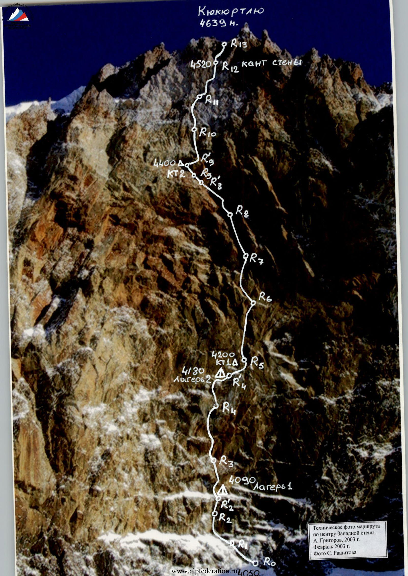 Technical photo of the route via the center of the Western wall, A. Grigorov, 2003. February 2003. Photo by S. Rashitov.
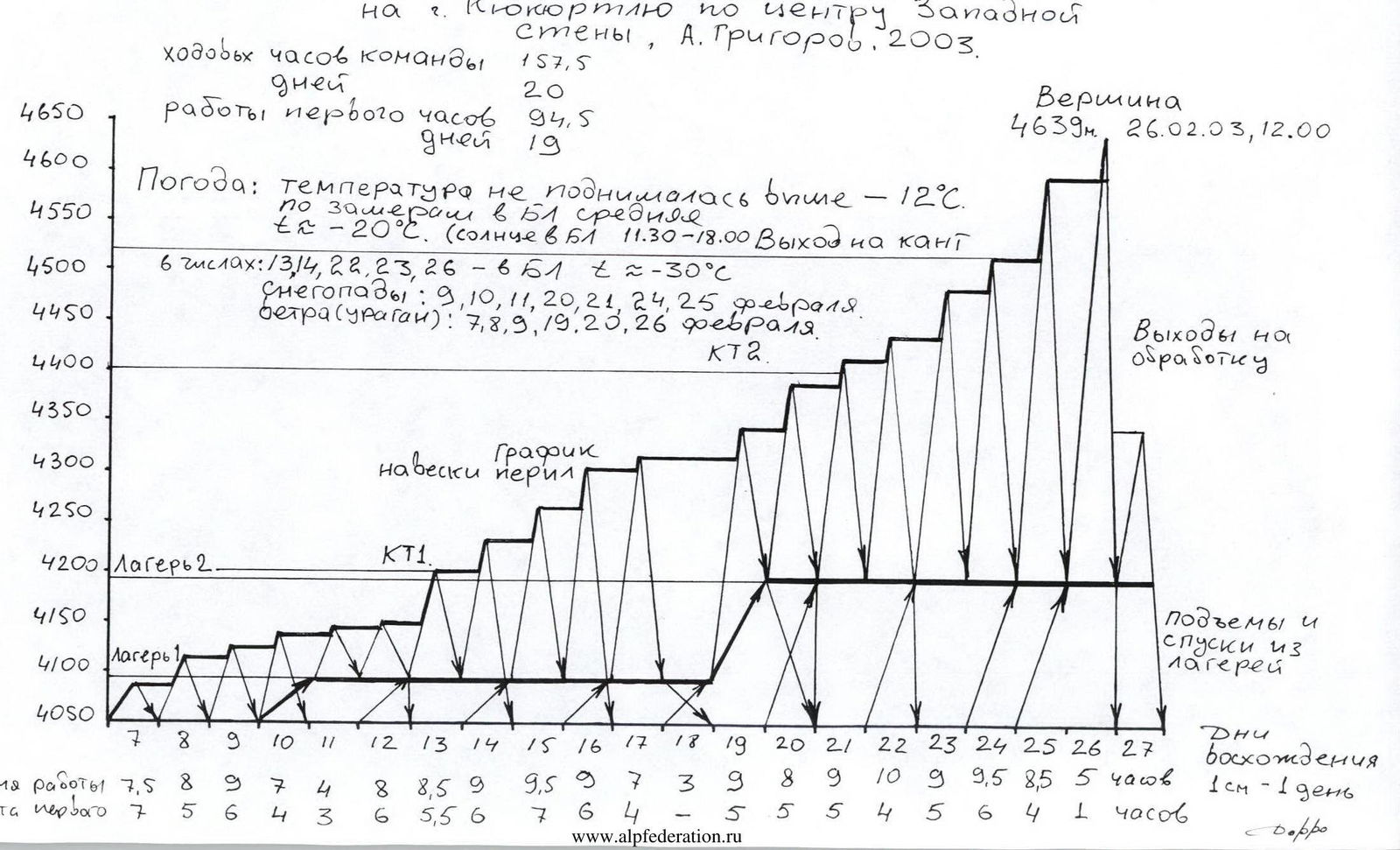 Ascent graph for Kyukyurtlyu via the center of the Western wall, A. Grigorov, 2003.
Route Scheme
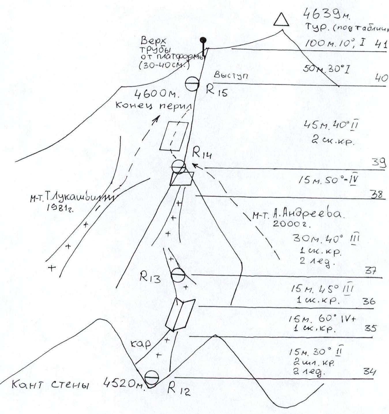 Route scheme in UIAA symbols. Kyukyurtlyu, 4639 m, via the center of the Western wall, A. Grigorov, 2003.
Total on the route: rock anchors 79/62, bolt anchors 66/251, skyhooks, anchors, fifas 69/55, artificial anchors 64, length 515 m, slope 83°, difficulty VI.
| Pitch # | Rock anchors (total/left) | Bolt anchors (total/permanent) | Skyhooks, anchors, fifas (created/total) | Artificial anchors (total) | Length (m) | Slope (°) | Difficulty |
|---|---|---|---|---|---|---|---|
| 41 | 2/2 | – | 2/2 | 12 | 15 | 90 | V1, A3 |
| 40 | 2/2 | 1/1 | 3/3 | 19 | 25 | 90 | V1, A3 |
| 39 | – | – | 3 | – | 10 | 60 | IV |
| 38 | 2/1 | 1/1 | – | 8 | 30 | 10 | V+, A2-5M |
| 37 | 4/4 | 1/1 | 1/1 | 10 | 29 | 15 | V+, A3 |
| 36 | 3/3 | 2/2 | 5/4 | 12 | 28 | 20 | V+, A3 |
| 35 | 2/2 | 1/1 | 2/1 | 2 | 27 | 10 | V+, A3-5M |
| 34 | 6/6 | 5/5 | 2/2 | – | 26 | 10 | VI, A3 |
| 33 | 2/2 | 1/1 | 5/4 | 4 | 25 | 10 | V1, A2 |
| 32 | 3/3 | – | 6/3 | 16 | 24 | 20 | V+, A1-10M |
| 31 | 8/8 | 11/11 | 3/3 | 10 | 23 | 30 | V1, A2 |
| 30 | 3/3 | 3/3 | 1/1 | – | 22 | 5 | V1, A2 |
| 29 | 4/4 | 2/2 | 5/5 | 40 | 21 | 45 | V1, A2 |
| 28 | 3 | 1 | – | – | 20 | 10 | V+ |
| 27 | 2/2 | 1/1 | 1/1 | 8 | 19 | 10 | V1, A2 |
| 26 | 5/5 | 2/2 | 3/3 | 18 | 18 | 25 | V1, A2 |
| 25 | 3/3 | 1/1 | 3/3 | 8 | 17 | 15 | V1, A2 |
| 24 | – | 10/10 | 1/1 | – | 16 | 10 | V1, A2 |
| 23 | – | – | 2/2 | 9 | 15 | 10 | V1, A2 |
| 22 | – | – | 3/3 | 7 | 14 | 10 | V1, A2 |
| 21 | 3/3 | – | 1/1 | 7 | 13 | 10 | V1, A2 |
| 20 | – | 1 | 5 | – | 12 | 20 | IV |
| 19 | 3/2 | 2 | 5/4 | 3 | 11 | 20 | V+, A1-10M |
| 18 | 2/2 | – | 1/1 | 4 | 10 | 5 | V1, A2 |
| 17 | 1/1 | – | 6/6 | 19 | 9 | 25 | VI, A2 |
| 16 | 5/5 | 5/4 | 4/3 | 5 | 8 | 15 | V+, A2 |
| 15 | 2/1 | 6/5 | 2/2 | 6 | 7 | 20 | V+, A1-A2 |
| 14 | 1/1 | 1/1 | 3/3 | 7 | 6 | 10 | V+-VI, A1-A2 |
| 13 | 1 | – | 2 | – | 5 | 5 | III |
| 12 | 2/2 | 1/1 | 4/3 | 7 | 5 | 10 | V1, A2 |
| 11 | 2/2 | 2/2 | 2/2 | 10 | 3 | 20 | V1, A2 |
| 10 | 1 | – | 1 | – | 2 | 20 | III |
| 9 | 2 | 1 | 1 | – | 2 | 20 | IV |
 Sheet 4, page 8a. Route description on www.dgu.ru↗.
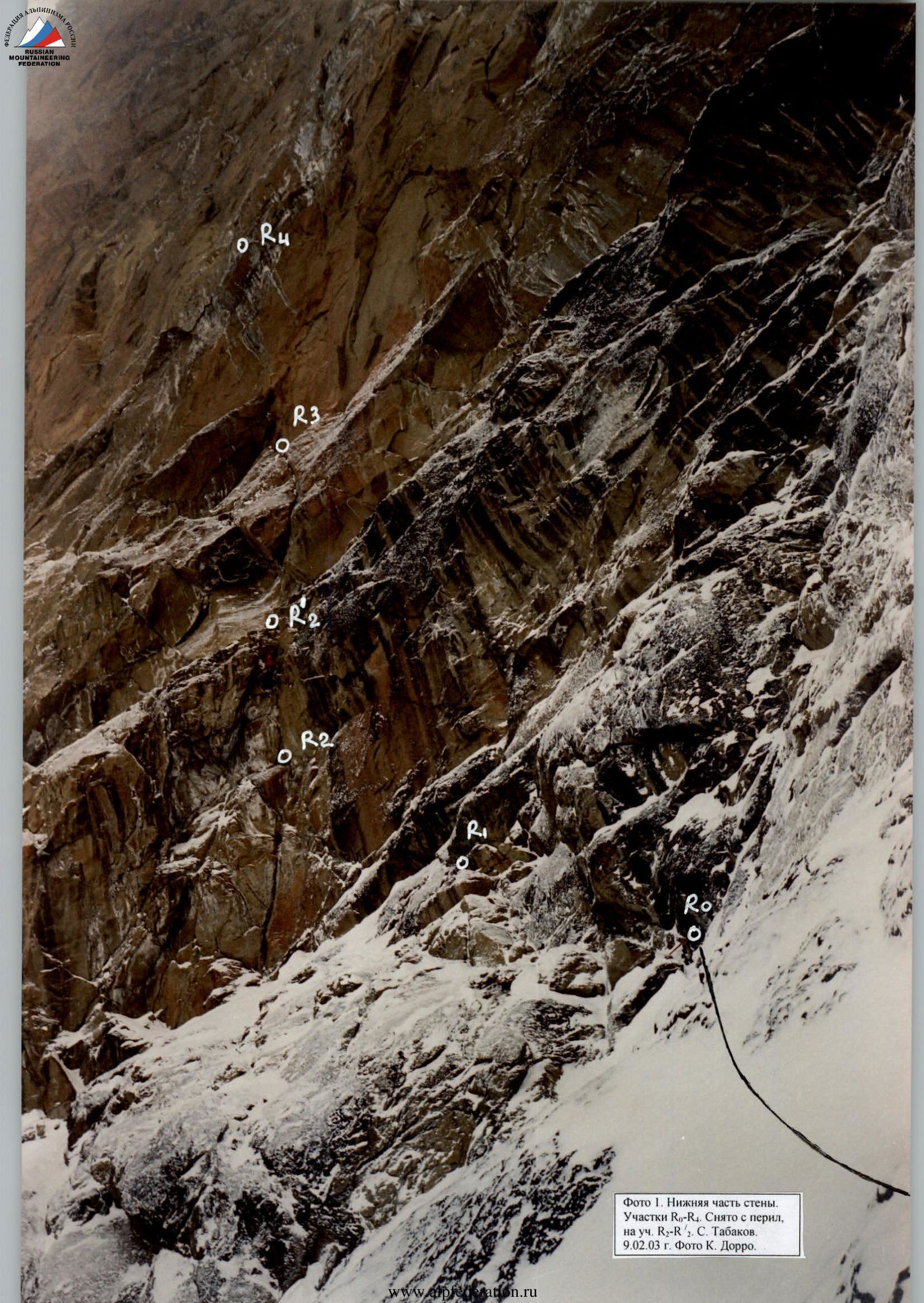
Photo 1. Lower part of the wall. Sections R0–R4. Taken from the ropes, on section R2–R2. S. Tabakov. February 9, 2003. Photo by K. Dorro.
 Photo 2. Section R3–R4 (ropes are straightened) O. Bibin on descent February 27, 2003. Taken from R3. Photo by K. Dorro.
 Photo 3. O. Tabakov on section R5–R6 (14). Taken from R5, from anchor point 1. February 14, 2003. Photo by K. Dorro.
Photo 4. S. Tabakov passing section 22, on R–R/8. Taken on February 20, 2003, from R8. Photo by K. Dorro.
Photo 5. Ascent via ropes on sections R5–R8. Taken downwards from R. Lower A. Grigorov near R6. Upper S. Tabakov near R7. Team started the ascent on February 26, 2003. Photo by K. Dorro.
Photo 7. S. Tabakov passing the upper ("gray") zone, section R11–R12. Taken from R11. February 24, 2003. Photo by K. Dorro.