Kjukjurtljü
TECHNICAL CLIMBING CLASS ON THE WESTERN TOWER

Report
USSR ARMED FORCES TEAM
TEAM LEADER: MSMA Yevgeny D. Zhizin DEPUTY TEAM LEADER: MSMA Leonid M. Matyushin MEMBERS:
- MSMA Alexander S. Chmykhov
- Dmitriy A. Maukauss
- Igor G. Khatskevich
TEAM COACH: MSMA Kirill P. Rototaev
The Kjukjurtljü massif, composed of volcanic rocks, is located in the western shoulder of Elbrus. Its summit (4623 m) is cut off by walls and towers on the Ullu-Kam and Kjukjurtljü glaciers.
Soviet climbers are familiar with the southern wall of Kjukjurtljü. Two routes lead to the summit:
- via the central tower of this wall (category 5B)
- via the eastern counterfort (category 5A).
Ten years ago, army athletes V. Nekrasov and G. Zhivlyuk were the first to ascend via the central tower. In 1962, another team of army athletes (K. Rototaev, A. Tkachenko, S. Artyukhin, S. Shchastny, and Ye. Zhizin) also completed this route. Members of our team, L. Matyushin, I. Khatskevich, and A. Chmykhov, ascended via the eastern counterfort of the wall.
Armed Forces climbers are well acquainted with interesting routes on the Kjukjurtljü walls. Our attention had long been drawn to the route on the western tower's wall. This path is logical, though challenging, and relatively well-protected from rockfall. The team coach, K. Rototaev, was the initiator of this route's ascent. In previous years, we studied this route and submitted an application to climb the wall in the 1967 USSR Championship.
The 1967 season in the Caucasus was marked by extremely unfavorable weather. Frequent rains and heavy snowfalls significantly complicated the condition of the routes. Many teams were forced to abandon their planned ascents under such conditions.
The USSR Armed Forces team, assessing the situation, decided to forgo the ascent of Ushba's southern peak via the eastern wall (the primary option in the technical climbing class).
It seemed reasonable to switch the team to the alternate option — the western tower's wall of Kjukjurtljü. The conditions for ascending this wall were less dependent on the snow and ice situation — the wall is very steep, snow does not stick to it, and the tuffs and light lavas it's composed of absorb moisture well. Therefore, significant glaciation was unlikely.
The entire route can be conditionally divided into three major parts:
- Slopes of the western ridge of Kjukjurtljü,
- The tower,
- The summit ridge.
The most challenging part of the route is the tower, where numerous difficult sections, sheer drops, steep slabs, overhangs, and cornices were expected. The complexity was also due to the structure of the volcanic rocks in the Kjukjurtljü massif, which greatly complicated the organization of reliable protection.
According to the organizational plan, after a series of sports and training ascents of categories 4 and 5 (including 5B), the team, fully equipped with gear and supplies, headed to the area of the planned ascent, conducted the necessary reconnaissance of the route, and observed the rockfall regime. After that:
- processed part of the tower's wall
- began the ascent on the route
The application listed the following team members:
- Team Leader — Master of Sports Kirill P. Rototaev (team coach)
- Deputy Team Leader — Master of Sports Yevgeny D. Zhizin
- Deputy Team Leader — Master of Sports Leonid M. Matyushin

Elbrus Area Map
CONVENTIONAL SYMBOLS:
- ● — Bivouacs.
- — — Team's route.
Numbers indicate section boundaries. Members:
- Master of Sports Alexander S. Chmykhov
- 1st Category Igor G. Khatskevich
- 1st Category Vladimir A. Baranov
Reserve members:
- 1st Category Alexander S. Maslennikov
- 1st Category Grigory G. Vardanyan
- 1st Category Pavel S. Goncharov
K. Rototaev could only participate in the training work and was then recalled due to work-related circumstances. P. Goncharov, A. Maslennikov, and G. Vardanyan did not participate in the training camp. V. Baranov suffered an ankle injury and could not join the ascent.
Thus, the team listed in the technical climbing class consisted of:
- Yevgeny Zhizin
- Leonid Matyushin
- Alexander Chmykhov
- Igor Khatskevich
In case one of the four team members became unable to continue, the ascent would be jeopardized.
The Armed Forces training camp leadership and the team approached I. I. Antonovich, a representative of the Federation and a judge, to request permission to include 1st-category climbers L. Ozeretskovsky and D. Maukauss, who were listed in the traverse class.
Permission was granted, and the team began the ascent with the following composition:
Team Leader — Yevgeny D. Zhizin, Deputy Team Leader — Leonid M. Matyushin
Members:
- Alexander S. Chmykhov
- Igor G. Khatskevich
- Dmitriy A. Maukauss
L. Ozeretskovsky was unable to join due to bad weather on another route.
A tactical plan was developed and adjusted before the ascent:
1st day. Departure to the Khotju-Tau pass. 2nd day. Transition through the Ullu-Kam cirque to the western ridge of the Kjukjurtljü massif. Organization of a bivouac. 3rd day. Observation of rockfall on the tower's wall, photo shooting, route reconnaissance, and clarification of the plan for ascending the tower. 4th day. Processing the lower part of the tower's wall, hanging ropes, and returning to the bivouac on the ridge. 5th day. Ascending the processed section of the wall, processing the upper part of the tower, reaching the top of the tower, and organizing a bivouac at the base of the next ascent. 6th day. Processing and ascending the ascent, reaching the ridge to a small depression. 7th day. Ascending the upper section of the route. Reaching the Kjukjurtljü summit. Bivouac. 8th day. Descent through the Kupol (summit 4965). 9th day. Return to Terskol. 10th and 11th days. Reserve time for bad weather.
Before departing on the route, the team was in good physical condition and was comprehensively prepared (physically, technically, tactically, and psychologically) for the ascent. All members had experience with complex wall ascents and good teamwork on such routes.
The team was provided with food for the entire duration of the ascent. Knowledge of the Kjukjurtljü walls' character facilitated the selection and preparation of necessary gear, which was well-tested in previous ascents, including a wide range of pitons.
To ensure the safety of the ascent, a plan for interaction with two groups from the training camps was developed. These groups were preparing to ascend Kjukjurtljü via the eastern counterfort (category 5A) under the leadership of T. Bakanidze and I. Goryachev.
According to this plan, the day after the team's departure, T. Bakanidze's group would reach the starting point of their route. On the third day, this group would reach the Kjukjurtljü summit and remain there until I. Goryachev's group, following a day later, arrived. After that, T. Bakanidze's group would continue to the western peak of Elbrus, while I. Goryachev's group would stay on the Kjukjurtljü summit until the team completed the ascent of the tower. Throughout this period:
- mutual observation would be maintained,
- communication would be kept,
- close interaction among all three groups would be ensured.
The presence of three qualified groups in close proximity significantly increased the reliability of the route ascents and served as an important morale factor contributing to the success of the ascent.
The organizational and tactical plans were executed, although the situation required additional adjustments.
For instance, fog covering the tower's wall on the morning of August 9 (the third day) prevented observation and reconnaissance of the route and clarification of the plan for ascending the tower. We had to limit ourselves to examining the lowest belt of the tower and postponed these tasks to the next day.
Furthermore, on August 11, we had to take a "rest day" due to bad weather. The plan was delayed by another day. However, we were able to traverse the summit ridge in 5 hours instead of two days, as the compact, frozen snow facilitated the passage of certain sections of this part of the route.
After waiting out the period of bad weather, on August 7, 1967, at 13:20, the team departed from Terskol to the Azau meadow, marking the beginning of the ascent plan.
By evening, we reached the Khotju-Tau pass, spent the night there, crossed the Ullu-Kam cirque, and began ascending the scree and snow slopes of Kjukjurtljü's western ridge.
Fog and snow showers hindered our movement and limited visibility.
Just below the ridge, we found a suitable spot for a tent and stopped for a bivouac at 17:00. At 20:00, we exchanged flares with T. Bakanidze's group.
On the morning of August 9, we ascended to the ridge. Zhizin and Khatskevich remained to photograph the Kjukjurtljü walls, while the other three climbed along the ridge to the base of the tower and established a bivouac two rope lengths away.
The Kjukjurtljü was shrouded in fog rising from below. We managed to take one photo hastily. We waited for several hours for the fog to clear, but it didn't.
Meanwhile, Matyushin and Chmykhov conducted reconnaissance. Traversing a steep snow slope on the ridge, they approached the base of the tower. They were able to examine the lower belt of rocks and outline a possible path through a small snow shoulder on the right side of the tower. The middle and upper parts were obscured by fog. We had to wait for better weather.
By 14:15, everyone gathered at the tent. At 15:00, sleet turned into snow, and wind picked up. Visibility was significantly reduced. Thunderstorm discharges were heard nearby.
We discussed the situation and decided that the next day would be dedicated to:
- detailed reconnaissance of the planned route;
- additional reconnaissance of the right couloir.
In the evening, we established communication with the interacting groups. On August 10, 1967, low-hanging clouds obscured the tower's summit from early morning. Fog rolled in from below.
During brief clearings, we glimpsed the wall. Many sections were covered in ice. By day, ice was likely to fall from the wall.
The task for the day was detailed reconnaissance of possible ascent routes — "reconnaissance in force." We needed to verify options not visible from the bivouac.
The Matyushin—Khatskevich team was tasked with reaching the R5 snow shoulder and examining the route on the right side of the tower.
The other team, Zhizin—Maukauss, was to:
- reconnoiter the path via the right (as viewed from below) couloir;
- assess the character of the tower's southern wall.
A. Chmykhov remained at the bivouac to observe the rockfall regime.
At 8:00, Matyushin and Khatskevich approached the base of the tower. They carefully examined the rocks and began their work.
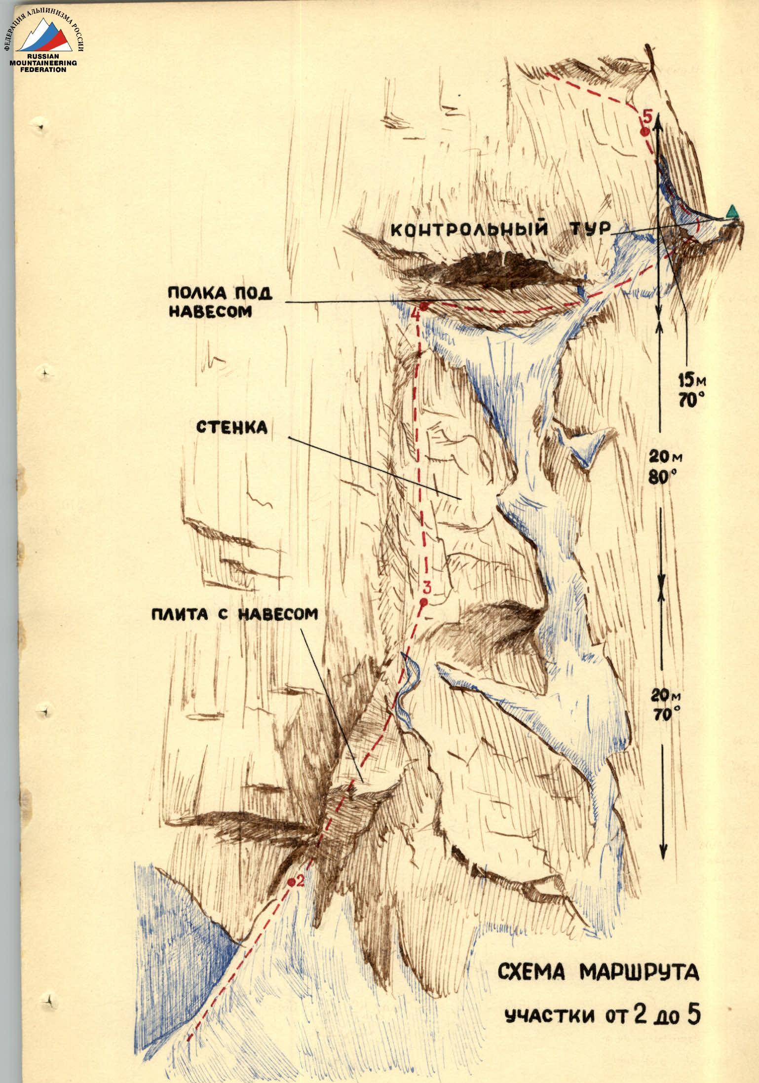
Before them lay a 20-meter monolithic slab with a steepness of about 70° and small, tile-like overhangs (R3). To the left stood a sheer wall composed of gray tuffs resembling dried earth, with protrusions and cracks. I. Khatskevich attempted to drive pitons into it but failed — pieces of rock broke off upon striking or loading the piton, and the search for cracks resumed.
When all possibilities to drive a piton were exhausted, we used drill pitons and ladders. The slab was ascended using complex climbing techniques — there were no cracks, and handholds were scarce. The wall gradually warmed up. Small pieces of ice and rocks fell from above.
In the upper part, the slab transitioned into a steep, wide groove (about 3 meters wide) with a flat bottom, composed of hard but brittle rocks with wide cracks (R4). Shoulder and long pitons held well in these cracks. Some small cavities formed by gas bubbles were encountered.
A "lift" (a free rope) was used to replenish the piton supply for the climber ahead. The second rope came into use as the first became difficult to pull due to friction.
By 11:30, the weather deteriorated — snow pellets turned into fluffy snow. Distant thunderstorm discharges were heard.
Progress was slow. After overcoming the groove, Khatskevich reached the ruined reddish rocks and continued to a ledge with snow under a large overhang, from which meter-long icicles hung.
Again, heavily cracked rocks resembling dried earth were encountered. A 30-centimeter narrow titanium piton was driven in.
From the ledge, Khatskevich ascended via snow, ice (4–5 m), and steep, brittle rocks to a narrow, snow-covered shoulder and secured the rope on a double piton (R5). Matyushin then ascended to him via the rope.
The task assigned to the team was accomplished. The path taken was challenging but feasible and relatively safe. Now, we could assess our surroundings.
Below, in the couloir, Zhizin and Maukauss were visible. Movement was possible:
- Downwards — towards Zhizin and Maukauss.
- To the right — a sheer wall exposed to rocks falling from the couloir.
- Straight up — smooth, layered slabs that could only be ascended with drill pitons.
- Upwards to the left — a possible ascent route worth considering.
The weather worsened. L. Matyushin led the way.
He managed to traverse the wall, which had a steepness of about 80°, for several meters (beginning of section R6). There were few handholds and cracks for pitons. Wet snow stuck to the rocks, masking the relief. The weather continued to deteriorate. However, the goal of the reconnaissance was achieved — further progress was possible. The team left the hung rope in place and descended to the bivouac by 15:30.
By this time, the Zhizin—Maukauss team had returned from their reconnaissance. Their findings were categorical — the couloir was impassable.
- The entire couloir was covered in ice.
- Rocks and ice continuously fell through it.
- Avalanches occurred.
- The wall of the tower on the couloir side was completely sheer and heavily exposed to ricocheting rocks.
The route reconnoitered by Khatskevich and Matyushin remained the only viable option. By general consensus, this route was logical and the safest.
By evening, the weather had not improved, and visibility was poor. We sent up a flare at the agreed time and received a response.
August 11. The snowfall that began the previous day continued throughout the night and most of the day with brief interruptions.
- The tent had to be dug out.
- The snow thickness reached 30 cm.
By evening, the snow stopped. The Kjukjurtljü tower emerged, covered in snow. Small avalanches descended one after another down the couloir.
The team did not leave the bivouac that day. At 17:00, we established voice communication with the interacting group on the Kjukjurtljü summit.
August 12. Clear, cloudless morning, strong wind. At 8:45, the Zhizin—Chmykhov team began processing the route.
- The rocks and rope were covered in ice.
- They had to climb the rope using clasping knots and leglifts instead of stirrups.
After 2.5 hours, the team reached the shoulder. Repeating L. Matyushin's traverse and ascending steep, inclined slabs and complex rock formations, Zhizin used pitons for protection and as artificial holds (leglifts) to overcome difficult, weathered rocks. In some places, the rocks overhung (R6).
Ice fragments began to fall from above but did not cause any issues.
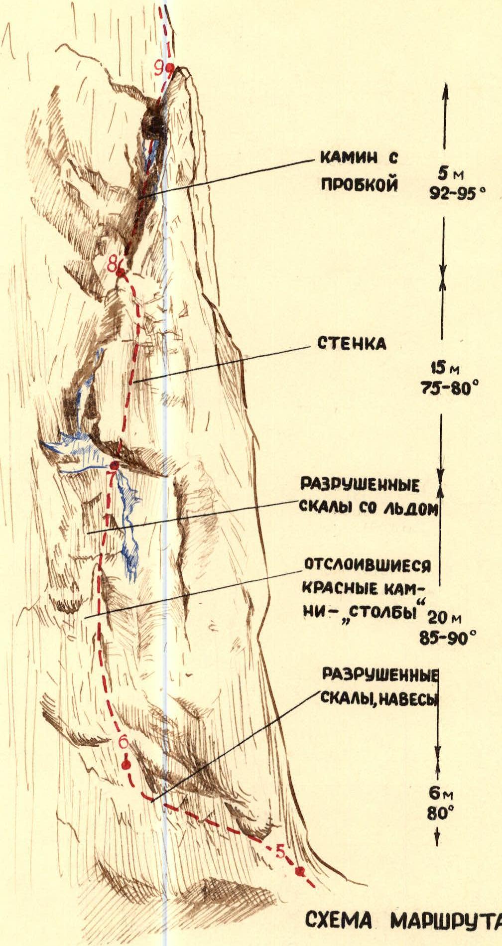
Above, there were two reddish, detached rocks, above which an overhanging ledge of fragmented, wet rocks with ice protruded. This laborious section (R7) was ascended using complex climbing techniques with pitons and leglifts.
At the top of the overhang, there was a trough-like couloir-chimney filled with ice, and above it, an icy platform. To the right of it stood:
- a 5-meter wall composed of unstable rocks;
- the wall had some handholds, but a leglift was used in one place.
Above the wall lay moderately difficult, weathered rocks leading to one of the most challenging sections of the route — an internal corner-chimney with a "plug" (R9).
This chimney was formed by a massive, detached slab, widening at the top. Its walls were covered in ice. To make matters worse, this 15-meter chimney overhung.
Two leglifts hung in the chimney allowed ascent to the plug. It became even more challenging. The plug was massive, and reaching its top was impossible. A piton had to be driven into the plug, but suitable cracks were absent.
Standing on a leglift, holding the lower part of the plug with arms, and leaning back with the entire body was very tiring. It took three attempts to:
- find a barely noticeable crack
- drive a titanium petal piton into it
A leglift hung on this piton allowed the next leglift to be placed on the pointed tip of the plug. The chimney was now "reduced to a manageable form."
At 15:30, the team reached the top of the detached slab, secured themselves, and prepared to continue. The path now led straight up.
Meanwhile, the remaining team members at the bivouac attended to important tasks:
- Maukauss carefully accounted for the food supplies and planned menus for potential bad weather;
- Matyushin closely observed each step of the team on the wall, sketched the traversed sections, noted the gear used (pitons, leglifts), and kept a chronometer;
- Khatskevich worked on improving the bivouac area — dug out the tent and dried clothes.
On the wall, work continued. Zhizin gradually gained altitude. On steep (up to 70°) slabs with few cracks and handholds, leglifts were used. However, after passing the chimney, these challenging rocks no longer posed any doubts — upward movement was possible.
Having ascended these rocks by 7 meters, the first climber reached the base of a vertical 10-meter crevice with a steepness of 80–85°. The crevice led to overhangs. Large blocks barely clinging to the wall were encountered. It was essential to be particularly cautious to avoid dislodging them with the rope. A hanging rock cornice was overcome using complex climbing techniques on the left via tile-like rocks with a steepness of about 75°. Leglifts were also used here.
Directly above the cornice, there was a sheer 2-meter wall. It was ascended in the left part. Slightly higher, there was a small ledge where one could rest.
On the traversed section (R10), ice pitons and ordinary long pitons performed well.
After replenishing the piton and carabiner supply, the first climber continued. Further up, there was a section of moderately weathered rocks (20 m) of moderate difficulty (R11). Again, heightened attention was paid to "live" rocks. A small, concave wall (about 3 meters) in the middle of this section was ascended using two leglifts.
Higher up, the steepness of the rocks decreased, but there was no convenient spot for the belayer. The entire rope was already used. Its end was secured on double pitons.
For convenience, a metal platform was used. Now, the movements of the climber at the top became much freer — the risk of accidentally dislodging rocks was minimized.
The upper part of the tower overhung, reliably protecting this area from rockfall. A few meters away, at the base of the overhang, an open ledge was visible. A short traverse to the left was planned for the next day. For now, it was time to rest.
There were no suitable spots on the wall for a good bivouac. Our tactical plan accounted for this. We did not plan for:
- sitting or hanging bivouacs.
The program for the day was completed, and morale was high. The team descended to the tent. At 19:15, everyone gathered at the bivouac, where they were greeted with joyful exclamations, a delicious dinner, and a barrage of questions.
In the evening, we communicated with Goryachev's group.
August 13. According to the plan, the team was to:
- traverse the hung ropes
- process the upper part of the wall
- reach the top of the tower.
The morning was clear, with a fresh wind. Light clouds did not portend any trouble. The panorama of the Caucasus mountains from Bezengi to Kara-Kaya was magnificent. Settlements were visible far down in the Kuban valley.
We departed at 8:00. The ascent of the backpacks was challenging and time-consuming — they often got stuck in the overhanging tile-like rocks. Complex maneuvers were required to extract them.
Once the backpacks were on the shoulder, Maukauss descended to join Zhizin at the top to process the upper part of the tower. Chmykhov had the most laborious task today — extracting pitons.
On the snow shoulder, we established a control cairn and left a note.
The newly processed section began with a short traverse to the left along a simple, open ledge littered with rocks. We established a second control cairn here.
Beyond the ledge lay a 20-meter rock wall with a blunt internal angle and a steepness of up to 90°. This was a very challenging section (R13), particularly due to the frequent presence of unstable, weathered rocks with white salt deposits. It was ascended using complex climbing techniques with six leglifts and very careful piton protection. Long titanium wedges and ice pitons driven into the rocks held well here.
Higher up, to the left, lay a somewhat easier section of weathered slabs (R14), which, however, required cautious navigation to avoid dislodging rock fragments onto those below.
The top of the tower was near, but considerable effort was still required to overcome another very challenging section — a 15-meter wide internal angle with a steepness of about 80° (R15). The few available projections and handholds were highly unreliable, and none could be trusted. Again, we had to drive pitons and hang leglifts.
Finally, at 16:30, the first climber reached the top of the tower, and the last followed at 19:00. The most challenging part of the route was completed. Ahead lay a heavily snow-covered, narrow rock ridge. Everyone was somewhat excited, but we knew that we couldn't let our guard down.
The backpacks had traveled the entire wall on ropes and were quite worn out. We sorted them out and began moving along the ridge, using:
- pitons
- projections
- ice axes for protection
After traversing 2.5 rope lengths, we found a suitable spot, leveled the snow crest, and set up a tent (R16).
August 14. The morning was wonderful. We allowed ourselves to rest a bit longer than usual. We departed at 9:00. At 20:00, we sent up a flare and settled into the tent in the dark.
The path followed the frozen snow from the previous night. We traversed one rope length to the left to the base of a rock massif, then ascended a wide snow couloir leading from the Kjukjurtljü summit to the upper part of the western wall. The slope steepness here was 45°. We then reached a rocky ridge and traversed about 30 meters along it, organizing protection via projections and ice axes. We ascended two rope lengths up a wide snow slope to rock outcrops. Teams alternated, cutting steps in the hard snow crust.
Moving along the base of the rocks to the right, we traversed four more rope lengths and reached the pre-summit ridge, ascending to the Kjukjurtljü summit at 13:00.
We removed our backpacks, patted each other on the back, and exchanged joyful exclamations. We retrieved a note from a cairn left by the interaction group led by I. Goryachev and left our own note, dedicating our ascent to the glorious anniversary of the Soviet government.
After resting, we began our descent at 14:00. The descent route passed through the summit 4965. Initially, we had to gain over 300 meters in altitude — such is the nature of this descent.
The pace was slow, but the descent was relatively easy. The weather deteriorated. The Kupol was shrouded in fog, and it grew cold.
We oriented ourselves by the slope direction — we needed to go upwards. When the slope flattened, we decided to stop. There were no landmarks for further navigation, and we were surrounded by dense fog.
At 15:30, the weather sharply worsened, and a snowstorm hit. Without delay, we began constructing a platform using:
- ice axes
- hammers
- crampons
- platforms
The tent was soon securely anchored, and we settled in for the night.
At 18:00, the storm subsided, and we reoriented ourselves, planning our descent. At 20:00, we sent up a green flare.
We discussed the day's events. Everyone agreed that the condition of the path from the tower to the Kjukjurtljü summit strongly depended on the snow conditions. Under different circumstances, with less snow or abundant loose snow, the route could become significantly more complicated. We were fortunate in this regard. The wall was ascended, and our task was accomplished. The night at almost 5000 meters passed calmly, and everyone was in excellent spirits.
August 15. After a good rest and waiting for the frozen tent to thaw, we continued our descent through the Old Kružozor to the Azau meadow and further to Terskol, where friends greeted us with an enthusiastic reception at the PDSA base.
Assessing the complexity of the route, the team concluded that it:
- deserved a category 5B rating;
- was among the most challenging routes in this category.
The team successfully completed the route, demonstrating:
- good mastery of complex climbing techniques;
- the ability to use modern gear correctly.
The team did not have a support group and managed entirely on their own. Observation was carried out by two interacting groups. Voice and flare communication were maintained with these groups according to the established scheme.
The team was well-trained, worked cohesively, and was well-coordinated. All team members were well-prepared for ascents of this class. There were no incidents, gear losses, or other issues on the route.
Captain of the USSR Armed Forces Team
Master of Sports of the USSR O. D. Drochman
(Yevgeny D. Zhizin)
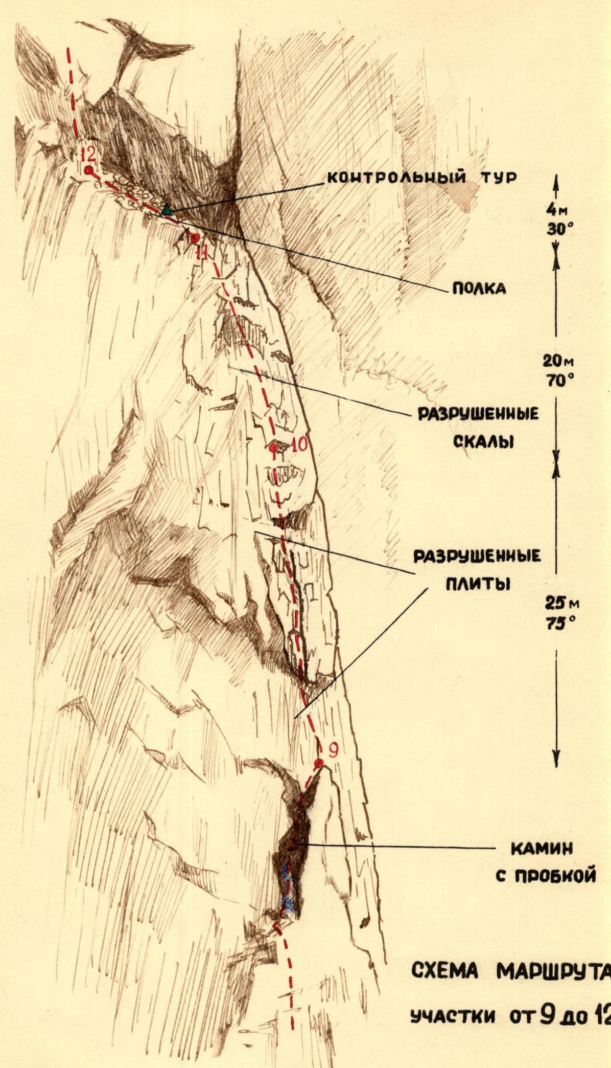
Route Diagram
Route Diagram
Sections from R5 to R9
 www.alp-federation.ru↗

ROUTE DIAGRAM. Photo 3. L. Matyushin traversing section R3 on a fixed rope. Small tile-like overhangs are visible below. Taken from below, looking up.
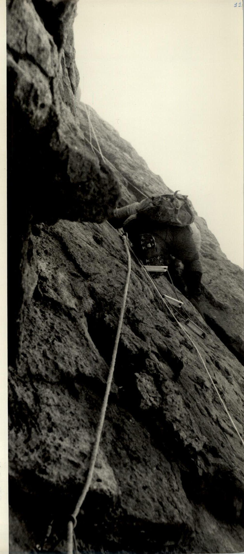
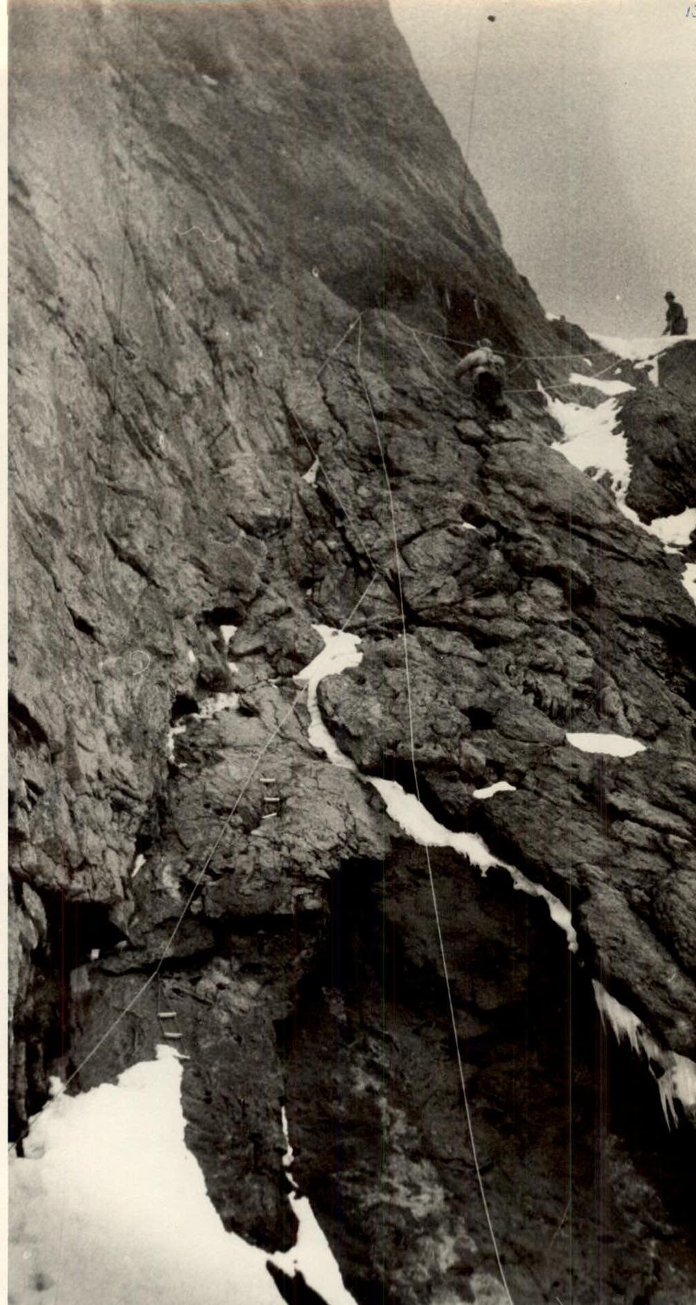
Photo 4. Section R5. I. Khatskevich has reached the snow shoulder and is accepting L. Matyushin. Taken along the slope from below.
1
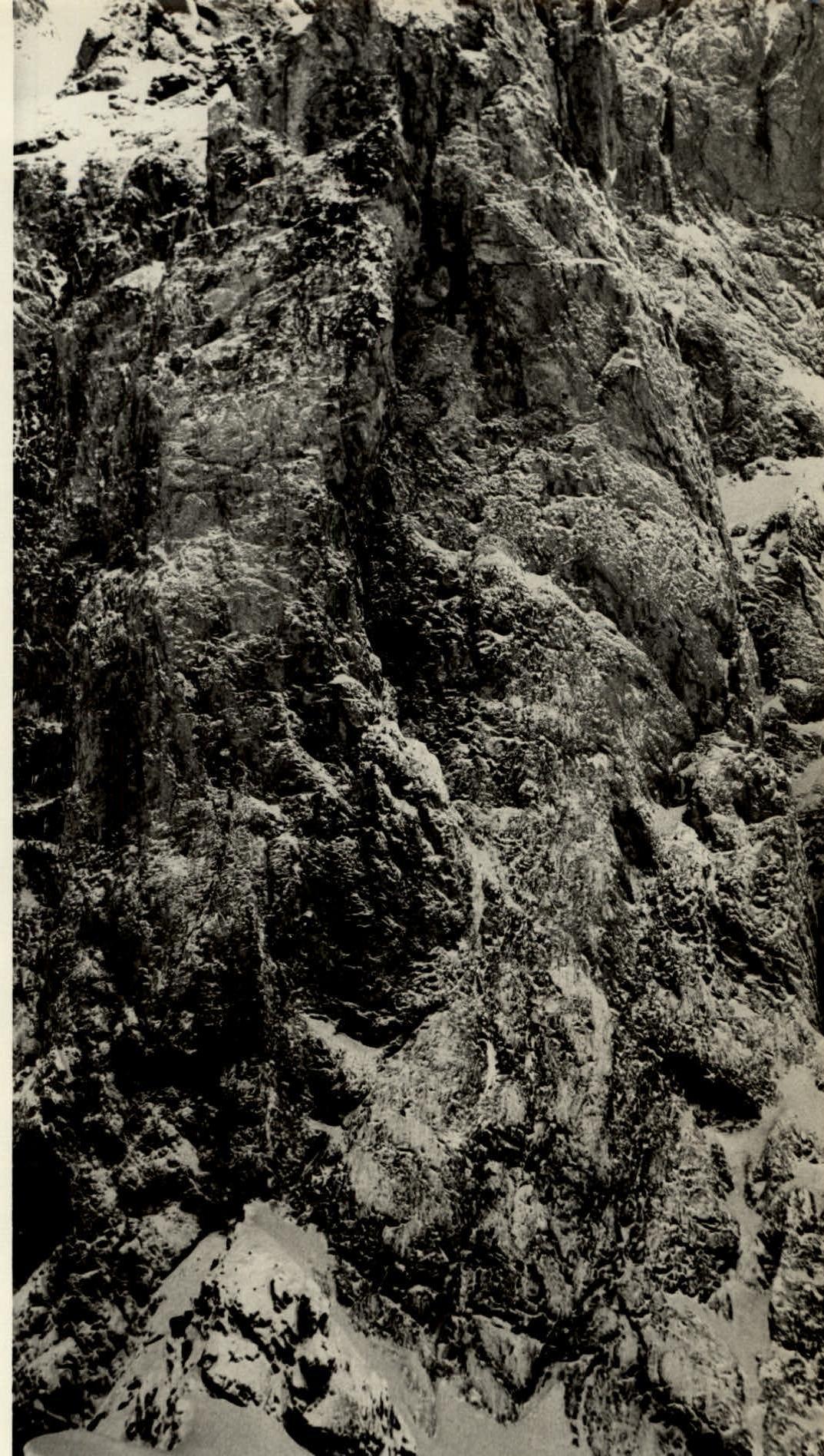
Photo 5. The tower's walls after snowfall.
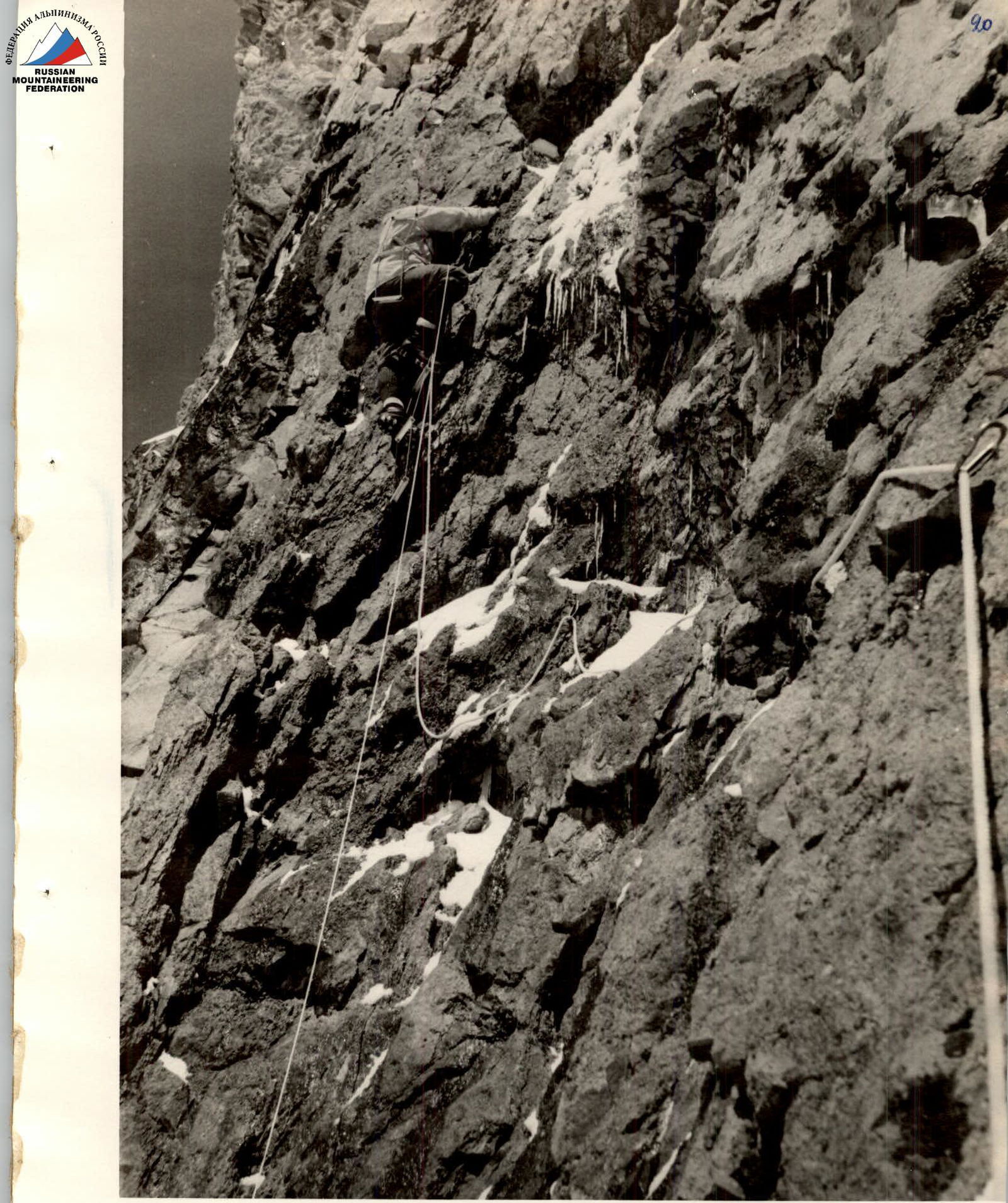
Photo 7. Leglifts are used in challenging sections (Section R7).
[^0]
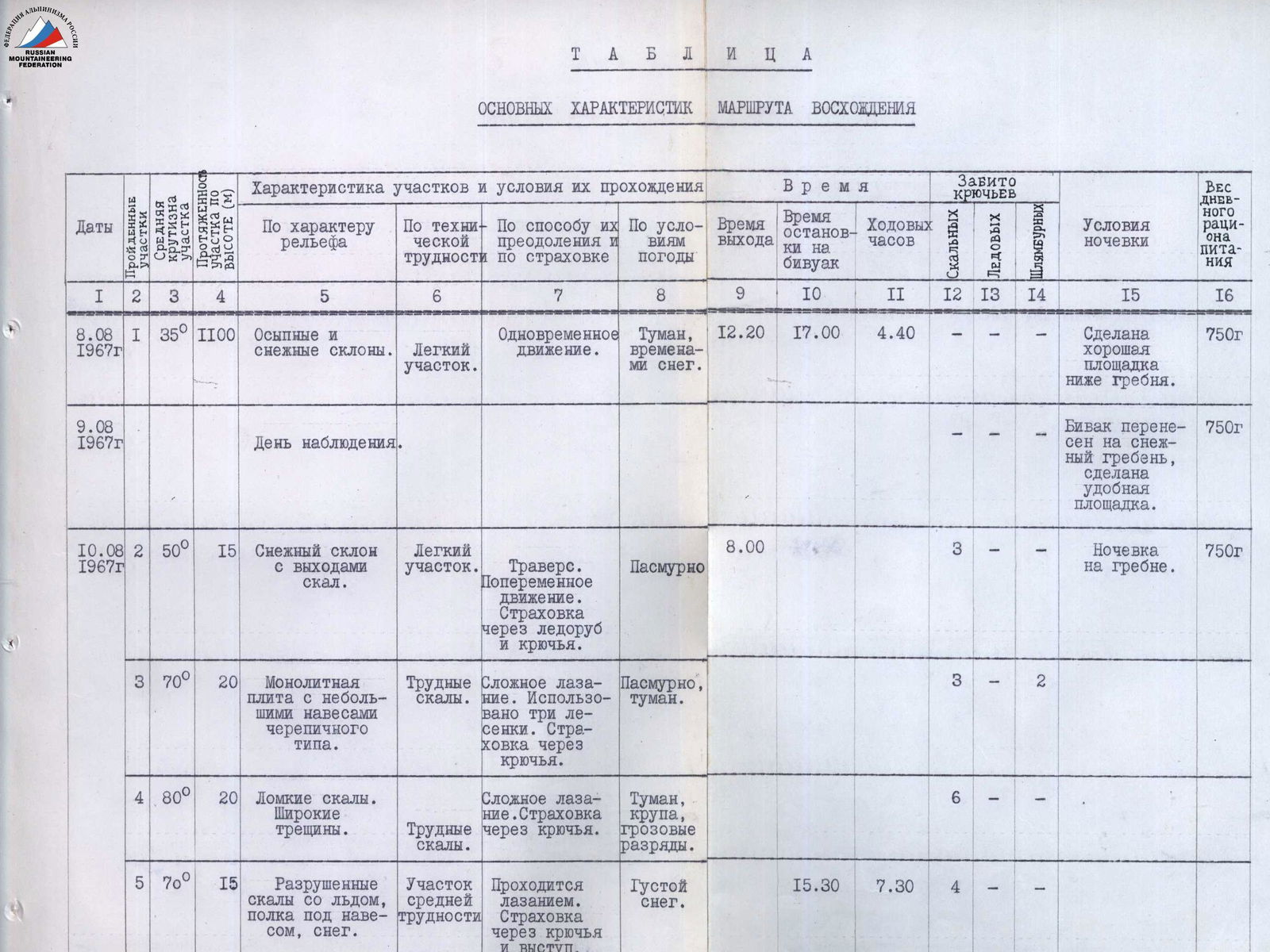
| Date | Section | Average Steepness | Height Gain (m) | Terrain Characteristics | Technical Difficulty | Method of Ascent and Protection | Weather Conditions | Departure Time | Stop Time | Climbing Hours | Pitons Driven (Permanent) | Pitons Driven (Forced) | Pitons Driven (Forced on Descent) | Bivouac Conditions | Daily Ration Weight |
|---|---|---|---|---|---|---|---|---|---|---|---|---|---|---|---|
| August 8, 1967 | R1 | 35° | 1100 | Scree and snow slopes. | 1 | Simultaneous movement. | Fog, occasional snow. | 12:20 | 17:00 | 4:40 | — | — | — | Good platform made below the ridge. | 750 g |
| August 9, 1967 | Observation day. | — | — | — | — | — | — | — | — | — | Bivouac relocated to the snow ridge, good platform made. | 750 g | |||
| August 10, 1967 | R2 | 50° | 15 | Snow slope with rock outcrops. | 1 | Traverse. Alternate movement. Protection via ice axe and pitons. | Overcast | 8:00 | — | 3 | — | — | — | Ridge bivouac. | 750 g |
| R3 | 70° | 20 | Monolithic slab with small tile-like overhangs. | 4 | Complex climbing. Three leglifts used. Protection via pitons. | Overcast, fog. | — | — | 3 | 2 | — | — | |||
| R4 | 80° | 20 | Brittle rocks. Wide cracks. | 4 | Complex climbing. Protection via pitons. | Fog, snow pellets, thunderstorm discharges. | — | — | 6 | — | — | — | |||
| R5 | 70° | 15 | Weathered rocks with ice, ledge under overhang, snow. | 3 | Ascended via climbing. Protection via pitons and projections. | Heavy snow. | — | 15:30 | 7:30 | 4 | — | — | |||
| August 11, 1967 | Bad weather day. | — | — | Snow, blizzard, wind, dry snow avalanches. | — | — | — | — | — | — | Ridge bivouac. | 750 g | |||
| August 12, 1967 | R6 | 80° | 6 | Heavily weathered, partially overhanging rocks. | 4 | Complex climbing using three leglifts. Piton protection. | Icy, snowy rocks. Clear, strong wind. | 8:45 | — | 6 | — | — | — | Ridge bivouac. | 750 g |
| R7 | 85–90° | 20 | Heavily weathered, wet rocks with ice. | 5 | Complex climbing using three leglifts. Piton protection. | Clear weather. | — | — | 5 | 1 | 2 | — | |||
| R8 | 75–80° | 15 | Rocks with handholds. | 3 | Climbing with piton protection. One leglift used. | — | — | — | 2 | — | — | — | |||
| R9 | 90–95° | 15 | Icy internal corner-chimney with a plug. | 5 | Complex climbing using four leglifts. Protection via pitons and projections. | — | — | — | 5 | — | — | — | |||
| R10 | 75° | 25 | Moderately weathered slabs. | 4 | Ascended via climbing. Five leglifts used. Piton protection. | — | — | — | 7 | 2 | — | — | |||
| R11 | 70° | 20 | Weathered rocks. | 3 | Ascended via climbing. Two leglifts and a platform used. Piton |