- Climbing type — rock climbing
- Central Caucasus. Shkhelda gorge (Double Glacier area)
- Peak Kavkaz 4037 m via the SE buttress.
- Difficulty category — 4A
- Route characteristics: a) elevation gain — 320 m; b) length of section R1–R2 — 40 m; c) average steepness — 60–65°
- Number of pitons hammered — 26 pcs.
- Climbing hours — 14 (including approach through Double Glacier)
- Climbing participants — rope team consisting of Chyorap A.G. — 1st sports category Popov A.E. — 2nd sports category.
- Team coach — Makhinov Anatoly Pavlovich
- July 9–10, 1980 
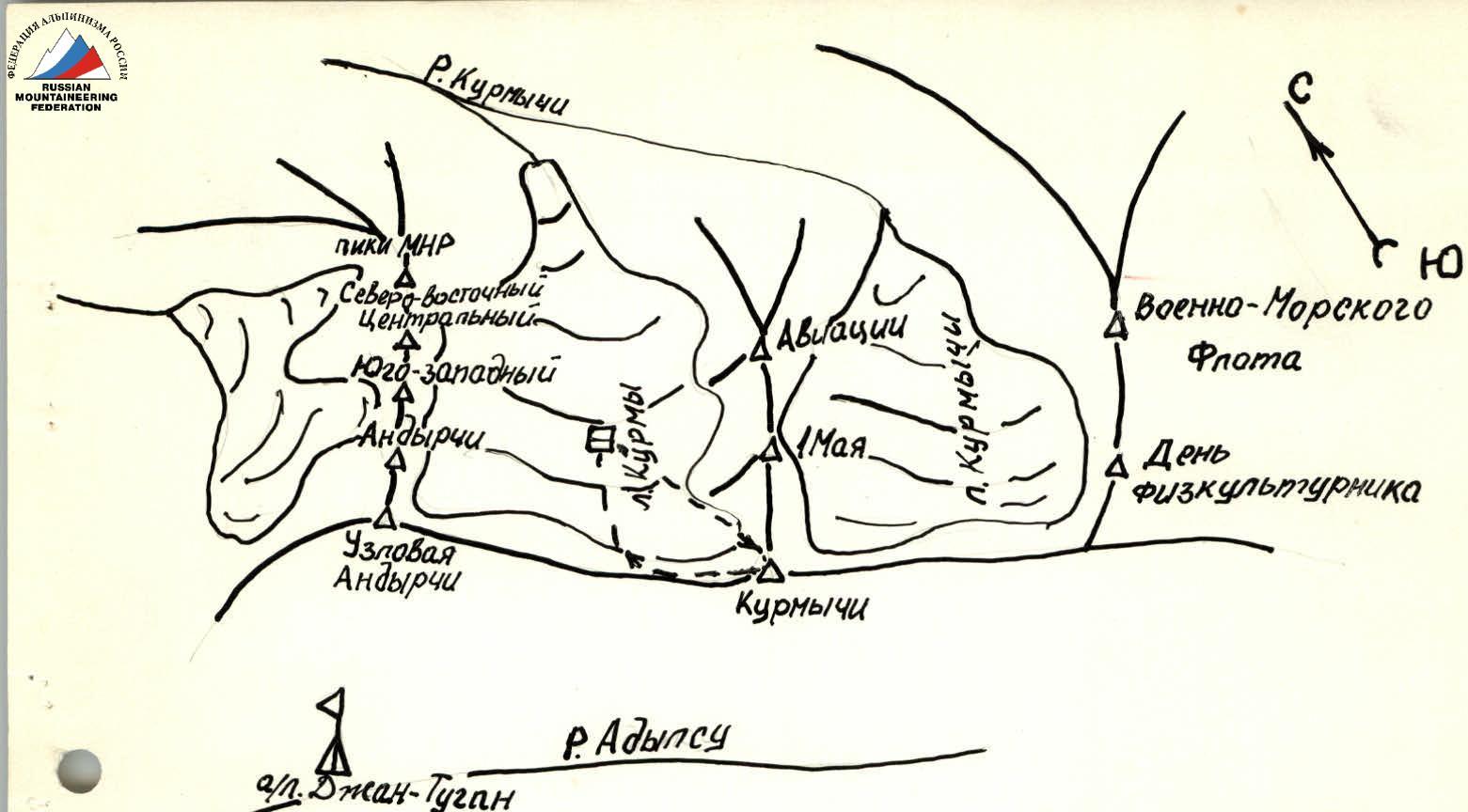
MAP-SCHEME OF THE CLIMBING AREA
Description
Central Caucasus Adyl-Su gorge July 1980
First ascent of the route, cat. diff. 4A, to the Western peak of Kavkaz via the SE buttress
July 9, 1980
From Shkhelda tourist camp along the Shkhelda gorge, follow the trail to the Shkhelda Glacier. Then, along the right lateral moraine of the glacier to where the Aksu Glacier joins the Shkhelda Glacier from the right. From here, move left and along the median moraine of the glacier (closer to its left part) in the direction of the lateral left-bank moraine of the Double Glacier, which flows into the Shkhelda Glacier from the left. Then, along the ridge of the left lateral moraine, navigate through large scree to where the moraine flattens out, where there are bivouac sites.
July 10, 1980
4:15 AM departure from the bivouac and then along the "Double" Glacier in the direction of the right snow-ice slope (see photo №1). Across the right part of the snow slope (45°) in crampons with alternating belay, we move towards the ice ridge, which is traversed from right to left in its lower part. The narrowest part — piton belay. Then, along the left part of the steep snow slope (50°, see photo №2) to the destroyed rocks of the ridge, which divides the glacier into two parts, and along them we ascend to the snow plateau, where there are bivouac sites on the left.
- The ascent from the overnight stay on the "Double" Glacier to the sites on the plateau takes 2 hours 30 minutes.
From the south, in the cirque of Peak Kavkaz and Peak Vuley, the Western peak of Kavkaz looks most impressive (see panorama of the cirque from the south).
From the sites, descend down the snow plateau in the direction of the wide snow couloir, which separates the Western peak and the Central peak. Across the snow bridge over the bergschrund and then into the left part of the couloir. Two rope lengths before the lateral couloir — ascent along the rocks of medium difficulty straight up (two rope lengths). Piton belay. A good landmark is the reddish wall, which remains on the left along the direction of movement.
Further, the route passes along the outer smoothed angle. Difficult climbing, when passing the outer angle, ladders are used in two places (one rope length). Then, along the ridge of the buttress and, staying on the right side of the ridge, along the rocks of medium difficulty to the saddle leading to the pre-summit ridge.
- Three rope lengths.
- Caution: rocks!
The exit to the summit is along a smoothed slab, from right to left (piton, belay two rope lengths).
Descent from the summit in the direction of the Shkhelda gorge along the ridge extending from Peak Kavkaz in a westerly direction.
Having descended into a wide couloir and then along it to the lower part of the snow plateau.
Descent into the couloir using sports method — four rope lengths until it flattens out.
Descent to the overnight stay along the ascent route to the snow plateau.
The route can be recommended for both sports teams and pairs.
Recommended equipment
(for a group of four)
| 1. Pamir tent | — 1 pc. |
| 2. Main ropes | — 2 × 40 m |
| 3. Rock hammers | — 2 pcs. |
| 4. Rock pitons | — 10 pcs. |
| 5. Ladders | — 2 pairs |
| 6. Expendable cordelette | — 5 m |
| 7. Crampons | — 4 pairs |
| 8. Ice screws | — 3 pcs. |
Sports teams can be recommended to use protection gear (cams, nuts, hexes) during the ascent.

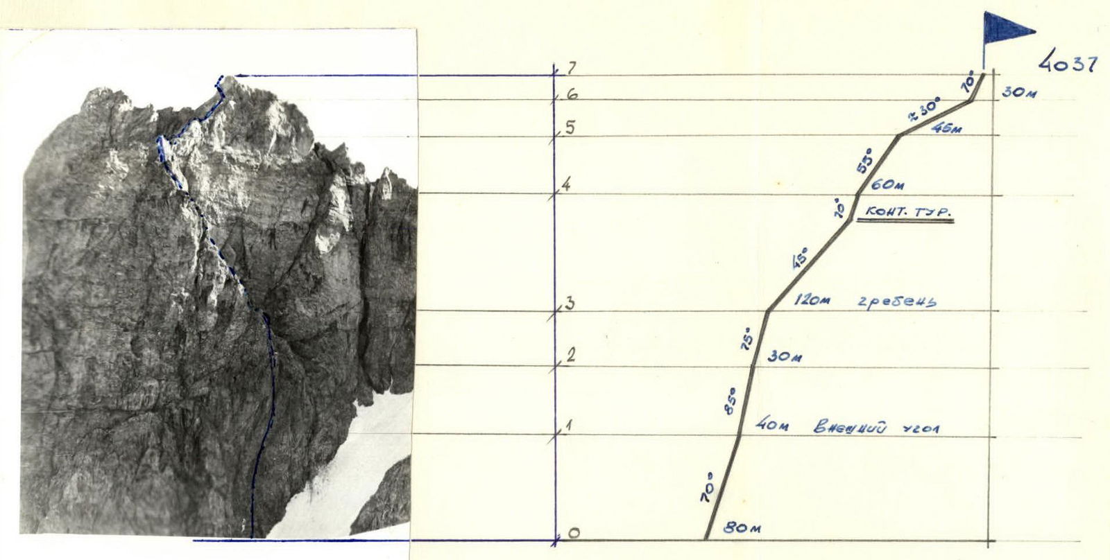
TABLE OF CHARACTERISTICS OF THE ASCENT ROUTE TO THE WESTERN PEAK OF KAVKAZ 4037 m
| Date | Sections traversed | Steepness in degrees | Length in m | Terrain characteristics | Tech. difficulty of section | Condition of section | Weather conditions | Belay (rock) | Climbing (rock) |
|---|---|---|---|---|---|---|---|---|---|
| July 10, 1980 | R0–R1 | 70° | 80 | steep rocks like "baranie lby" | IV | Loose rocks | good | 6 | free climbing |
| — | R1–R2 | 85° | 40 | outer angle | V | monolithic | good | 8 | two ladders |
| — | R2–R3 | 75° | 30 | wall | V | monolithic | good | 5 | free climbing |
| — | R3–R4 | average 57° | 120 | destroyed ridge | III | destroyed rocks | good | via ledges | simultaneous climbing |
| — | R4–R5 | 55° | 60 | steep ridge | II | monolithic | good | 2 via ledges | free climbing |
| — | R5–R6 | average 30° | 45 | gentle ridge | II | monolithic | good | via ledges | simultaneous movement |
| — | R6–R7 | 70° | 30 | steep slab | I | monolithic | good | 3 | free climbing |
DIVISION OF THE ROUTE TO THE WESTERN PEAK OF KAVKAZ 4A cat. diff.
Profile of the route to the Western peak of Kavkaz 4A cat. diff. 4034 m.
www.alpfederation.ru↗
Approach to the start of the route to the overnight stay on the Kurmy Glacier:
From the "Djan-Tugan" alpine camp, move up the road, then along the trail of the Adylsu gorge. Having passed the Koshi glade, behind a small drying stream, turn left and along the trail, ascend first through the forest, then through grassy slopes, and further through scree to the exit to the V.Ts.S.P.S. pass. From the "Djan-Tugan" alpine camp — 4–5 hours.