
CAUCASUS CHAMPIONSHIP 1986
Rock Climbing Class


Via the right buttress of the East wall
First Ascent
Category 5B difficulty (approximate)
USAB "Baksan" Team
Team leader — Valentin Aleksandrovich Kudryavtsev, Candidate Master of Sports
Team coach — Viktor Antonovich Yakovina, Master of Sports of the USSR
Addresses and phone numbers:
- 361603, KBAASSR, post office "Elbrus", USAB "Baksan"
- Team captain: 305040, Kursk, Aerodromnaya st., 7, apt. 4, Valentin Aleksandrovich Kudryavtsev
- Team coach: 252003, Kiev, Pushkinskaya st., 12, apt. 20, Viktor Antonovich Yakovina
Elevations were determined using an altimeter and corrected against a map.
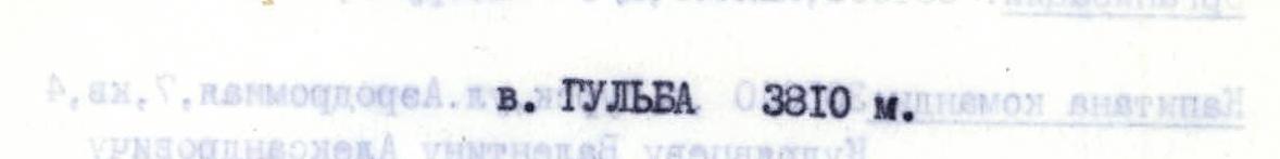
Photopanorama of the area. Shot: July 9, 1986, 9:00 AM, point M1, distance 5.5 km, elevation 4200 m. T-43 4/40 lens, focal length 40 mm.
Routes:
- team route;
- route via the East ridge, category 3A;
- route from the left peak of Gul, category 1B.

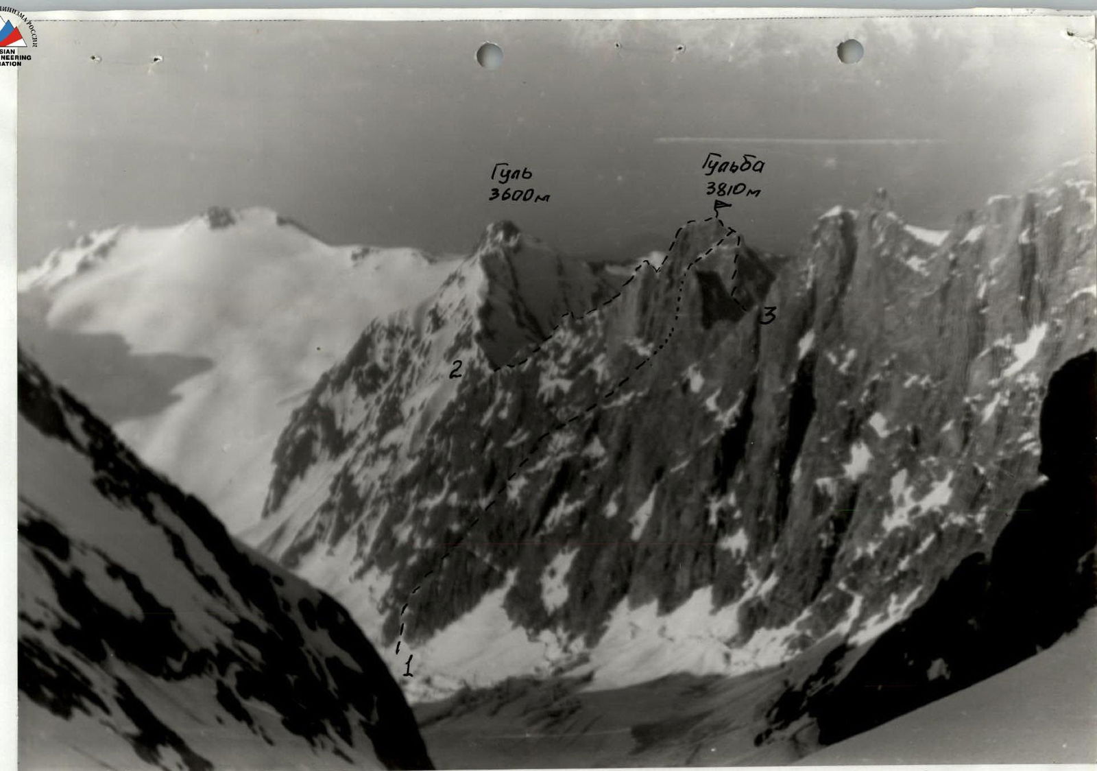
Photo of the wall profile from the right. Shot: point #3, July 9, 1986, 3:30 PM, elevation 3150 m, distance 3.0 km. Lens: T-34 4/40 LOMO, focal length 40 mm.
— — — team route
∼∼ — overnight stays
Team's Tactical Actions
The tactical plan for the ascent was developed by the team based on preliminary reconnaissance conducted in July 1985. The approach paths, overnight stay locations, and time required to cover key sections of the route were planned. Visual inspection of the intended route using a telescope allowed the team to determine the necessary equipment. During the ascent, the team used the following new and modern equipment:
- Shock-absorbing anchors;
- Adjustable protection elements of three sizes: 25–45 mm, 35–55 mm, and 45–65 mm.
- Small aluminum jammers weighing 40 g, used for ascending vertical fixed ropes using the chest (ascender) — foot (jammer) system.
- Polyethylene tubes with an inflatable frame for organizing overnight stays, weighing 300 g. The tubes were designed for two people.
Prior to the ascent, the following work schedule was planned:
- July 8, 1986 — transfer from USAB "Baksan" to Ushbinskoye plateau.
- July 9, 1986 — descent through Chalaatsky pass to the Western branch of Chalaat glacier, photography, inspection, and processing of the route's starting point.
- July 10, 1986 — departure from the assault camp at 7:00 AM, stop for a bivouac at 6:00 PM, organization of the bivouac and processing of subsequent route sections until 8:00 PM.
- July 11, 1986 — departure from the bivouac at 7:00 AM, reach the summit by 6:00 PM, descent via the Southeast ridge with organization of a bivouac on one of the ridge's flattened sections.
- July 12, 1986 — descent to the assault camp via Gul pass and ascent to Chalaat pass. Bivouac on Ushbinskoye plateau.
Alternative plans:
-
traverse to Mazeri village via Gul pass
-
ascent via the Eastern branch of Chalaat glacier to Chaтын South pass
-
July 13, 1986 — transfer from Ushbinskoye plateau to "German overnight stays" — USAB "Baksan".
Alternative plans:
-
Chaтын South pass — "German overnight stays" — USAB "Baksan"
-
Mazeri village — Becho pass — USAB "Baksan"
-
July 14–15, 1986 — reserve days in case of bad weather.
On the nights of July 9–10 and July 10–11, it rained, there was a thunderstorm, and fog was observed in the mornings. Due to this, instead of the planned morning departures at 7:00 AM, the departures were delayed until 10:00 AM and 11:00 AM, respectively.
Each team member had an individual nutrition kit (dried fruits, candies, crackers, glucose, and a flask with tea) and a first-aid kit. Each rope team was equipped with a bivouac kit for two, which included, in addition to personal down jackets, a two-person "leg" and a polyethylene tube with an inflatable frame.
The group worked in two rope teams:
- V. Krugloenko — Kudryavtsev;
- Shilo — Domrachev.
Rope team 2 processed and traversed sections R0–R6, with Shilo leading on R0–R4 and Domrachev on R4–R5. Rope team 1 processed and traversed sections R6–R10. Kudryavtsev led on R6–R8, and Krugloenko on R8–R10. Typically, the team captain, Kudryavtsev, followed second, which allowed for effective management of the group's progress.
Sections R0–R2 and R6–R7 were processed the day before they were traversed. All sections of category 5–6 difficulty were traversed with fixed ropes.
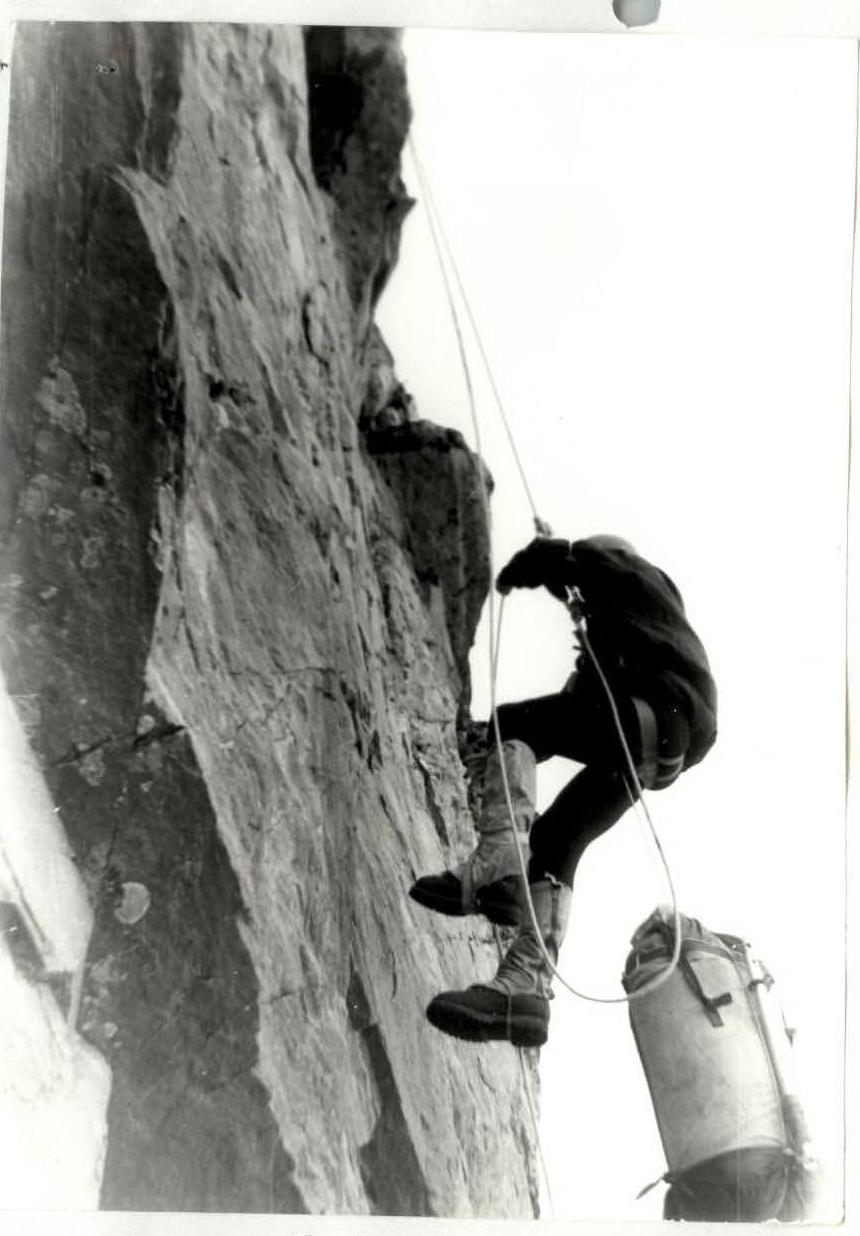
Each participant worked on a double rope.
On sections R2–R3 and R6–R7, the first climber's backpack was hauled up.
On section R9–R10, the group ascended with three backpacks. The first climber's backpack was distributed among the other backpacks. At the points where the first climber's backpack was hauled, the other participants' backpacks were attached to their harnesses.
When organizing fixed ropes, the upper and lower anchor points were secured to anchors.
The overnight stay on July 10–11, 1986, on section #6 was on a snow ridge. The platform was carved out of the snow, and fixed ropes were organized for both tubes and secured to the rocky ridge using outcrops and channel hooks. A P- belay stood above the platform, but the location of the ridge prevented falling rocks and ice.
The group's descent began at 6:30 PM via the Southeast ridge, category 3A. Thirty minutes after starting the descent from the summit, the route was completely fogged in. To ensure safe descent, it was decided to return to the summit and continue descending via the Northeast ridge, category 1. Part of this ridge was traversed during the ascent, and the remaining part of the ridge, a snow slope from the col, and the glacier traverse were well observed from the summit. At 8:00 PM, they stopped for a bivouac on a gentle part of the glacier.
July 12, 1986
- Departure from the bivouac — 7:00 AM.
- Ascent to Gul pass took 4 hours.
- After inspecting the Eastern branch of Chalaat glacier, it was decided to return to base via Gul and Becho passes.
- The team then followed the alternative return plan.
- 2:00 PM — descent from Gul pass to the assault camp on the Western branch of Chalaat glacier.
- After crossing Gul pass, they stopped for a bivouac at 7:30 PM near the "Shkhra" tourist base.
July 13, 1986
- Departure — 7:00 AM.
- Crossing Becho pass and descending to base was done under hail and rain.
- They reached base by 6:00 PM.
Communication was maintained through a liaison group based on Ushbinskoye plateau. There were no communication disruptions. The Ushba icefall, which can take 4–8 hours to cross depending on its condition.
The descent from Chalaat pass initially passes under the walls of Malaya Ushba down to the lowest rock outcrops, then through the center of the Western branch of Chalaat glacier to the icefall, which is traversed under the slopes of Chatyn or the more rockfall-prone slopes of the South ridge of North Ushba. Both paths require multiple rope descents.
It is also possible to approach via South Chatyn pass, but the lower icefall of the Eastern branch from the summit of Gulba and Gul pass was observed to be even more complex than the icefall of the Western branch of Chalaat glacier.
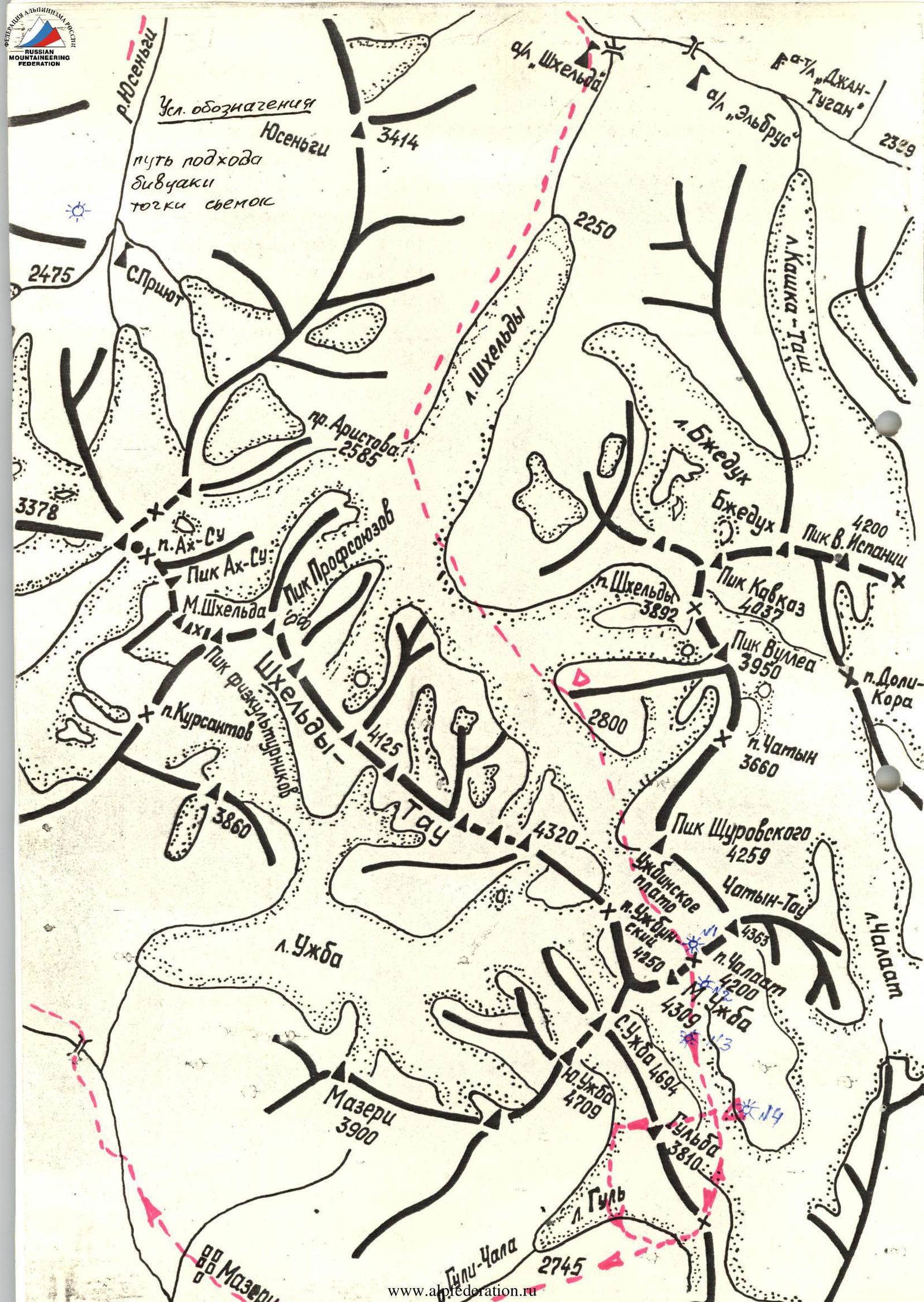
Brief Overview of the Ascent Area
The peak Gulba is located in the relatively unvisited Gulsky spur, which branches off from the southeast wall of North Ushba. The spur separates the Gul glacier and the Western branch of Chalaat glacier. The Gul glacier flows from the Ushba saddle to the southeast into Svaneti. In mid-summer, the glacier is broken in its lower part but is passable. The Western branch of Chalaat glacier is characterized by numerous closed crevices in its middle and upper parts and a difficult-to-pass icefall in its lower part under the col between Gulba and North Ushba. Crossing the icefall during ascent will require the use of special ice climbing equipment.
Two relatively straightforward routes have been classified on peak Gulba:
- In 1931, a group led by Popov pioneered a route of category 1 difficulty via the Northwest ridge.
- In 1959, a group led by Logvinov ascended via the Southeast ridge, which was classified as a category 3A route.
Gul pass, situated between peaks Gulba and Gul, is straightforward from the east and is traversed via snow slopes and broken rocks of category 1–3 difficulty from the west.
The East wall, with a height difference of over a kilometer from the glacier to the summit, is dissected by rockfall-prone couloirs and two distinct buttresses. The lower part of the wall is largely monolithic, while the upper part is composed of heavily weathered rock. Routes via the buttresses have a ridge-like character and consist of a combination of snow and rock in the lower part and rock, snow, and ice in the upper part. The buttresses offer sufficient locations for anchoring and overnight stays. Overall, the buttresses comprise a series of rock walls with inclinations of 60–85°, separated by more gentle snow ridges.
Approaches to the routes on the East wall are varied. From the Baksan valley, the simplest path goes through Becho pass to the village of Becho and then via the abandoned village of Gul along numerous trails to the upper pastures on the slopes of Gul peak to overnight stays near the moraine of Gul glacier.
From the overnight stays to Gul pass, the path goes along scree-covered slopes (3–4 hours).
The ascent to the Western branch of Chalaat glacier begins from the North ridge of Gul peak, 100–120 m from the pass, and proceeds along snowy scree and rocky ridges to the lower part of the couloir descending from Gul pass. The snowy-icy slope at the end of the couloir is intersected by a wide bergschrund.
A shorter but technically much more challenging path goes through Chalaat pass, situated between the peaks of Malaya Ushba and Chatyn. The ascent to it goes via Shkhelda valley to "German overnight stays" (from Shkhelda alpine base — 4–6 hours). Then, the ascent continues to Ushbinskoye plateau via
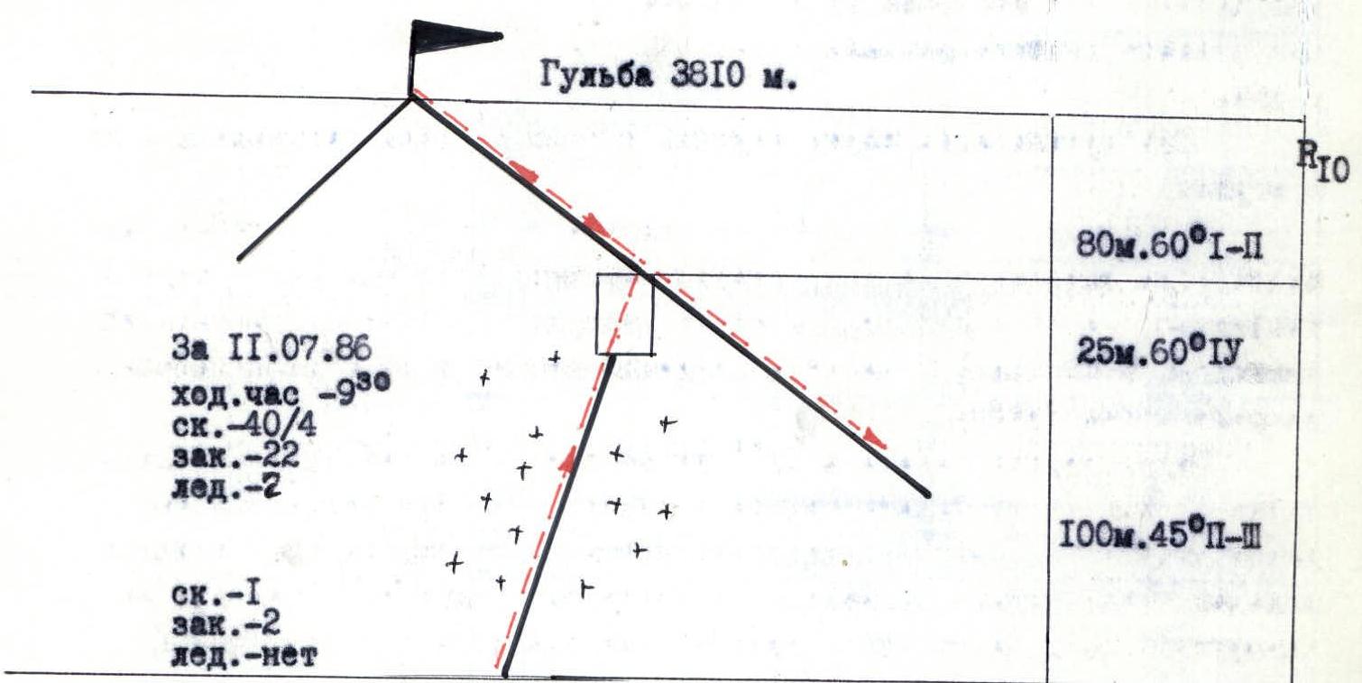
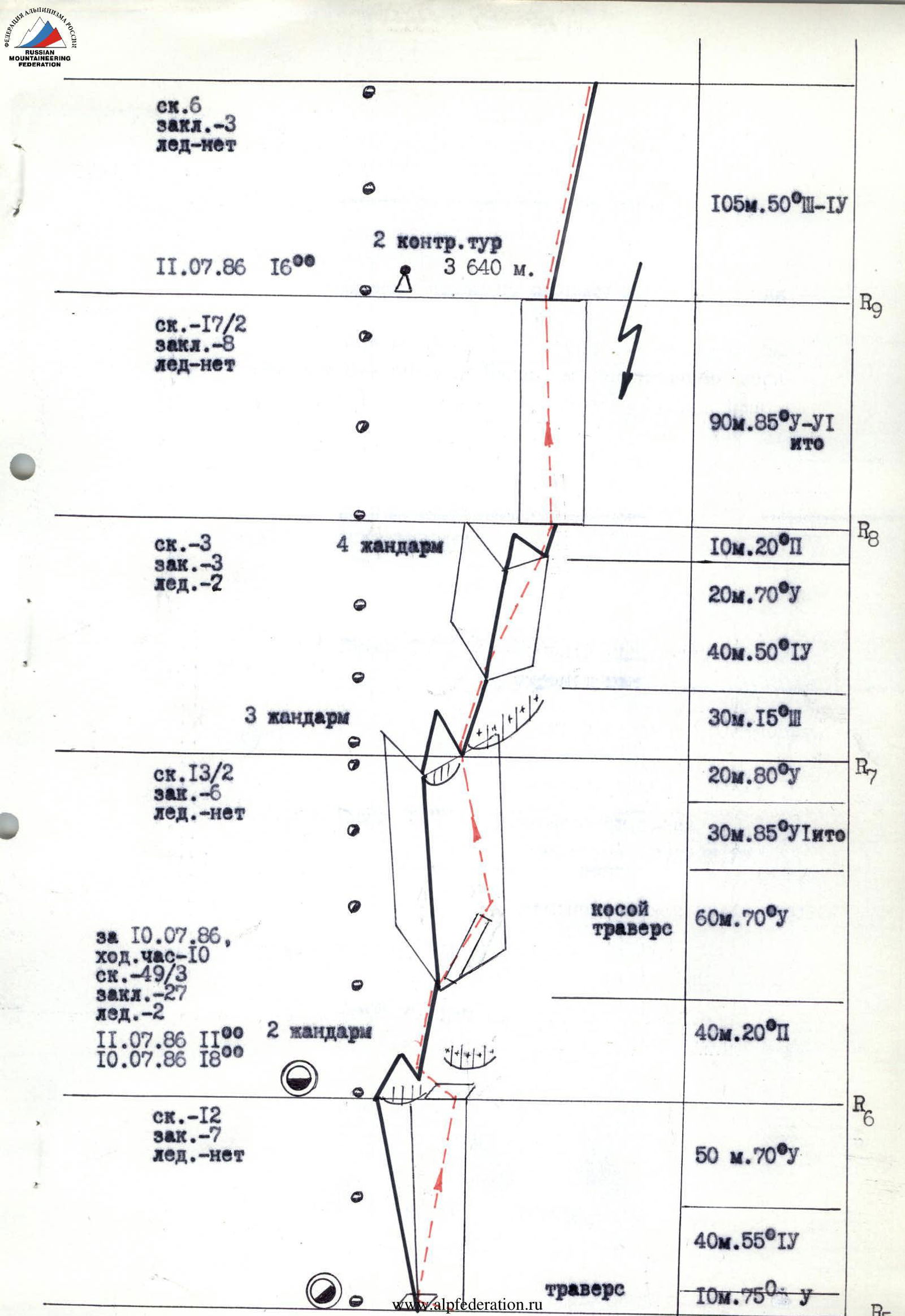
DRAWN PROFILE OF THE ROUTE, SCALE 1:4000
Route Diagram in UIAA Symbols
For the entire route:
rock – 89/7
fixed protection – 49
ice – 5

Route Description by Sections
R0–R1. Snowy-icy slope with a wide bergschrund, traversed via a snow bridge. Further — an internal snow-filled corner, at the end of which there is a ledge on the right for two people. The rocks on both sides of the corner are like "ram's foreheads".
R1–R2. A difficult internal corner with an exit to a snowy platform. The rocks are monolithic with convenient holds and are traversed by free climbing with a lightened backpack. The wall rising from the platform is monolithic with a limited number of cracks. The cracks are covered with damp moss. The wall ends in a weathered ridge, suitable for organizing an anchor.
R2–R3. A ridge with numerous loose stones in its lower part and monolithic in its upper part, with sufficient cracks for protection. The ridge leads to an overhanging wall with a chipped section on the right. It is traversed by free climbing without a backpack using ladders. Wide protection elements and petal hooks can be used. In the upper part, the rocks are more smoothed with a very limited number of cracks and are traversed on friction.
R3–R4. A ridge leading to the "Finger" pinnacle. At the beginning of the steep part of the ridge — a 10-meter wall, which was traversed on the left using two ladders. The only deep crack goes up the wall to the left. A reliable anchor can be made at the exit to the ridge. Under the wall on the left is a steep snowy slope, and on the right is a steep couloir going down. In the upper part, the ridge breaks into a series of small buttresses leading to the "Finger" pinnacle. The exit to the ridge beyond the pinnacle is via weathered rocks on the left.
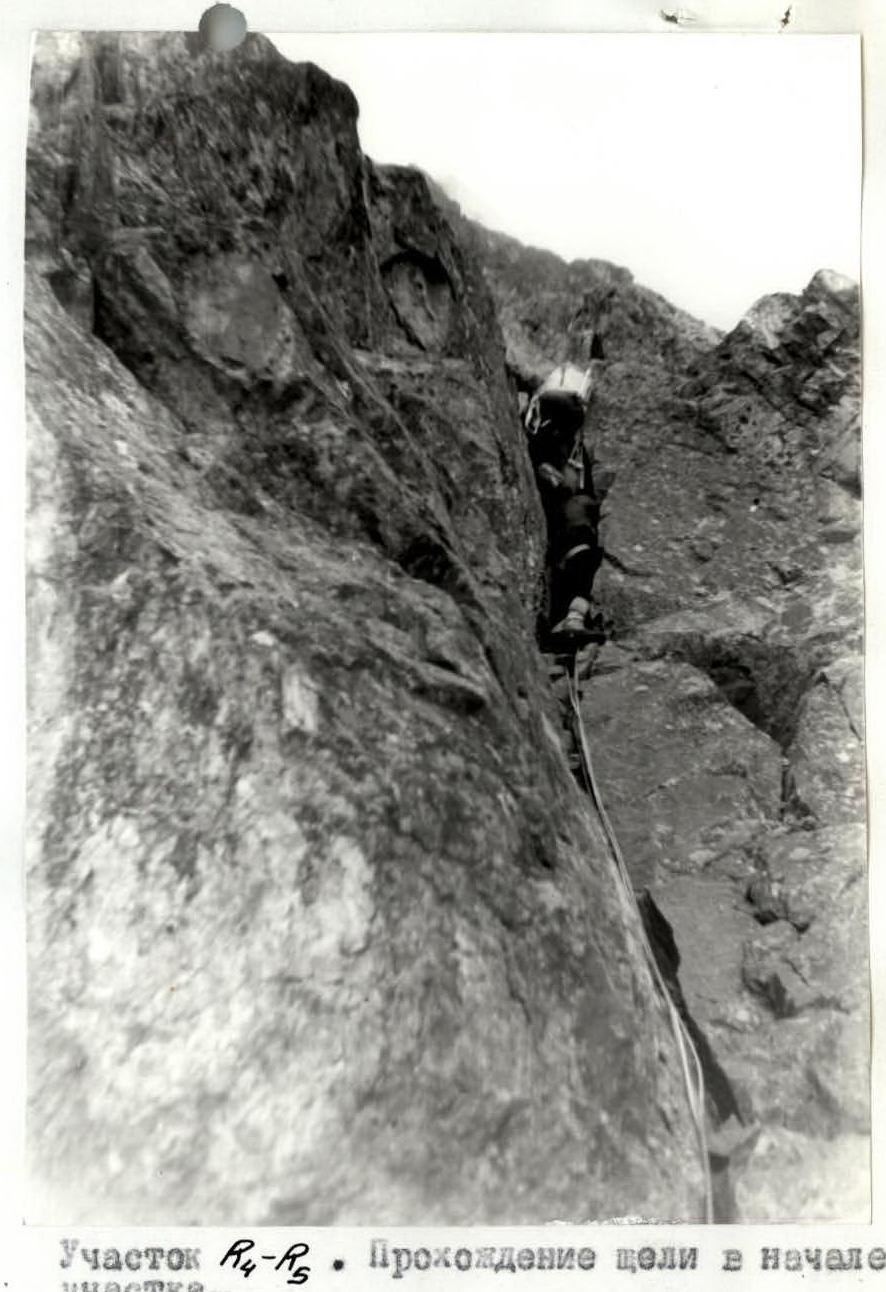
R4–R6. From the pinnacle, a ridge composed of large blocks continues. 20 m from the "Finger" pinnacle, it abruptly becomes vertical. The ascent is traversed on the right side. Initially along an inclined ledge and then via a crack. The first climber, going without a backpack, was boosted up. Further ascents were made along the wall to the right of the ridge. The wall alternates between rocks of category 3–4 difficulty and sections 5–8 m long with a very limited number of cracks and holds. Midway through the section, there is a platform on the left side of the ridge suitable for organizing a sitting bivouac. The second pinnacle is bypassed on the right along the wall between the rocky and snowy cornices. The final 20 m of the wall are wet rocks with verglas.
R6–R7. A gentle ridge composed of large blocks with a snowy cornice on the right, leading to the third pinnacle. The pinnacle is made of heavily smoothed rocks like "ram's foreheads". The right side of the pinnacle has a more dissected relief. The central and left sides are virtually crack-free. The pinnacle is traversed on the right side, initially along a discontinuous diagonal ledge and then via wet, partly iced rocks, exiting onto a sharp snowy ridge beyond the third pinnacle. The first climber worked without a backpack.
R7–R8. A sharp snowy ridge with a cornice on the right, transitioning into a steep, heavily weathered rocky ascent. The exit beyond the fourth small pinnacle to the subsequent snowy ridge is complicated by a steep wet wall. The rock is composed of heavily weathered formations. The first climber worked without a backpack.
R8–R10. A pre-summit tower with a roof. The 90-meter tower is composed of monolithic rocks with a limited number of cracks and holds. It is traversed by free climbing without a backpack. The re-clip point is a hanging anchor. There are sections of wet rocks. The roof is composed of heavily weathered rocks, partly covered with snow. The exit to the Northeast ridge is via a weathered wall.
Section R1–R3. Traversing fixed ropes. Shot: July 10, 1986, point 15, 1:00 PM.
Lens: T-34 4/40 LOMO
Section R1–R2. Traversing the slot at the start of the section. Shot: July 10, 1986, 4:30 PM.
Lens: T-34 4/40 LOMO, focal length 40 mm, shot point 16
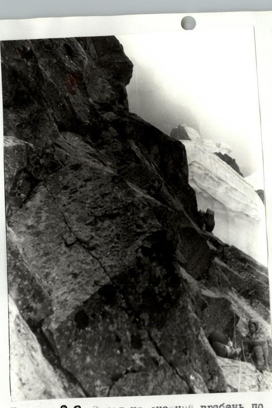
Section R6–R7. Exiting onto the snowy ridge via the second's fixed ropes. Shot: July 11, 1986, 12:30 PM. Lens: T-34 4/40 LOMO, focal length 40 mm. Shot point 17.
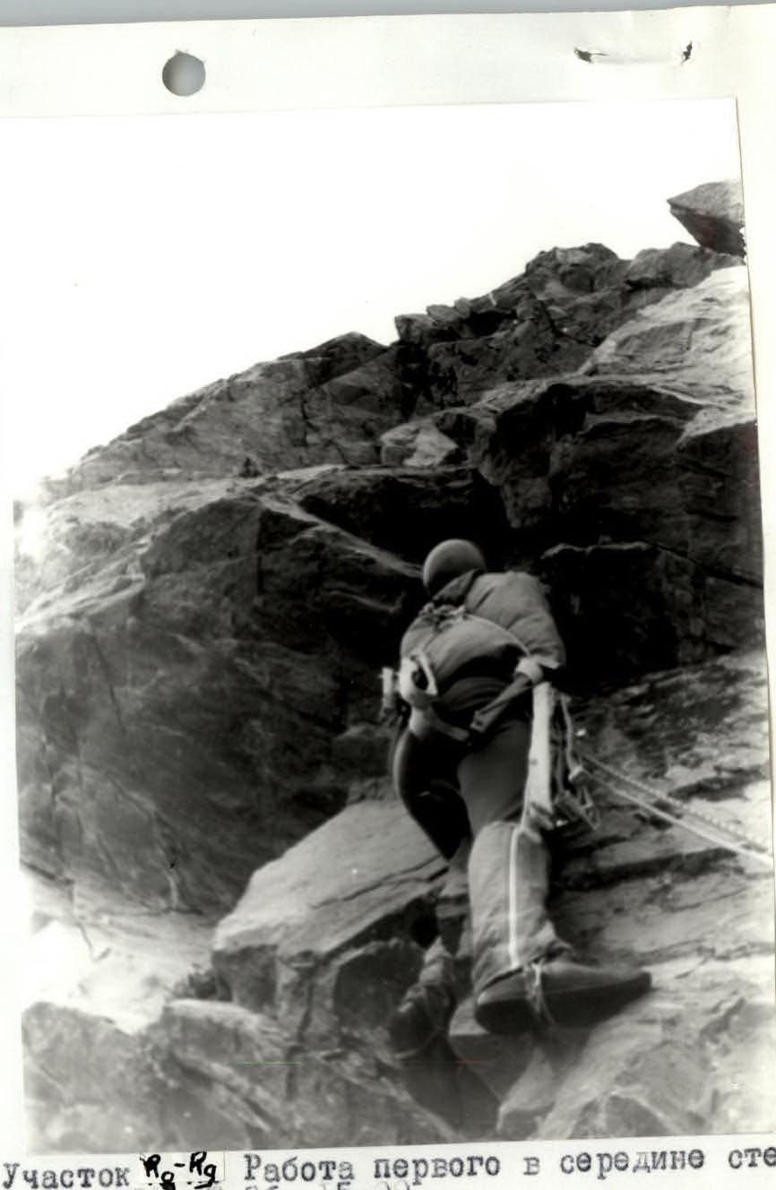
Section R7–R8. The first climber working in the middle of the wall. Shot: July 11, 1986, 3:00 PM. Lens: T-34 4/40 LOMO, focal length 40 mm. Shot point 18