May 12, 1949 Sports Society “Lokomotiv” Group
The group consisted of Garf (climbing category), Marupin, Baldin, Mikhailov, Povarnin, Radovskaya, and Nekrasova. After an overnight stay at the “Lokomotiv-Tuva” hut, also known as the “Green Hotel,” they departed at 5:00 AM to ascend Peak Germogenova via a new route. The path follows along the right (orographically) moraine of the Bashkara glacier until it reaches the cirque. The cirque is traversed in a northwest direction, [illegible, possibly omitted] to reach the base of the couloir descending from the saddle between Peak Germogenova and Cheget-Kara-Bashi. They had to overcome a small icefall, which was easily bypassed on the right. The group reached a small glacial lake and took a short rest.
It was 7:00 AM, and they were at the base of the couloir from the saddle between Peak Germogenova and Cheget-Kara-Bashi. As they ascended the avalanche cones, they quickly gained altitude via the couloir, which had a gradient of about 30° in its lower section and increased to about 50° in its upper section.
 The couloir is quite wide (60–70 m²) and covered with good firn. It is the main route for all avalanches and rockfalls coming from the slopes of Peak Germogenova and Cheget-Kara-Bashi. A deep avalanche groove runs through the middle of the couloir; however, the avalanches are so powerful that they overflow the right groove, affecting a significant part of the slope.
At 10:00 AM, the group, having traversed about half of the couloir, reached the base of the eastern wall of Peak Germogenova. At this location, a steep couloir descends from the wall (from the eastern buttress), bordered by smooth slab-like rocks. The path through the couloir itself is too hazardous due to frequent rockfalls.
The group moved to the right onto the rocks and traversed 100–120 meters of difficult slabs, which were inclined downwards with very few handholds. The path is highly exposed. Protection was provided by pitons.
The slabs end at a small couloir with a stream running through it. After 40–50 meters, the couloir turns into a chimney with overhanging wet walls. The chimney is bypassed on the right via a sheer wall 50–60 meters high. There are very few handholds. In one place, a piton was used as a support. Above the wall lies a platform and even a firn ridge with a gradient of about 45° and a length of 60 meters. It leads to a group of rocks that are bypassed on the right. Further ascent involves 150 meters of snowy slope with a gradient of 50–55° to the mouth of a rocky couloir. At this point, on a ledge beneath the right wall of the couloir, they found the first suitable spot for an overnight stay. On a small cornice, all seven members managed to huddle together under an overhanging rock, sheltered by two “Himalayan” tents used as “Zdarsky” tents. Since they were pitching on a slope, they had to stretch a handrail between two pitons and secure themselves with carabiners. They apparently stopped for the night at 7:30 PM. A thunderstorm struck at 9:00 PM and continued until midnight. However, the rock overhanging them provided good protection from the snowfall. They slept very little due to the uncomfortable position. They departed at dawn the next morning. A short traverse to the right and upwards, followed by difficult rock climbing (2 ropes), led them to a second snowy couloir with a gradient of about 50°. The protection was unreliable because there was ice under the snow, and the ice axe only penetrated halfway.
The couloir, 100–120 meters long, then transitions into the rocks of the southeastern ridge. Another rope of difficult climbing, and they reached the ridge; after a short stop, they began to progress along the ridge. They overcame two small gendarmes, 20 and 30 meters high, head-on.
The upper part of the ridge is snowy, 150 meters long, with a gradient of about 40°. The ridge at this point is very narrow and slopes towards the south. The rocks drop off into steep slopes. Towards Cheget-Kara-Bashi, there are нависают карнизы (overhanging cornices).
At 12:40 PM, they reached the summit! The descent followed the normal route to the Kashka-Gash glacier, and they arrived back at the “Lokomotiv” camp that same evening. The total height of the eastern wall from the main couloir descending from the saddle to the summit is more than 600 meters. The ascent of Peak Germogenova via the eastern wall is assessed as category 4 difficulty.
Captain of the 1st team of the Sports Society “Lokomotiv”, Master of Sports. /Garf/
Route Diagram in Symbols

Route Sections
- R9 – 40 m, 2
- R8 – 40 m, 2
- R7 – 80 m, 5
- R6 – 100 m, 5
- R5 – 15 m, 6
- R4 – 40 m, 5
- R3 – 220 m, 5
- R2 – 90 m, 5
- R1 – 40 m, 3
- R0 – 120 m, 2
Number of Ice Pitons Used
- 21
- 5
- 6
- 7
- 28
- 4
- Total: 76
Path to the saddle between Chegetkara and Peak Germogenova. Ak – control tour. M 1:2000
Brief Explanation of the Route Diagram
I. After a low-snow winter, the north wall of Peak Germogenova was almost completely free of snow at the time of the ascent. A small amount of snow remained on sections R7 and R8. The rest of the wall was entirely icy. In the presence of significant snow on the north wall, an ascent via this route can only be recommended on a frosty night.
- The steep 80° ice wall above the rocky “nose” is bypassed on the left via its less steep section. Bypassing the wall on the right is undesirable due to possible rockfalls from the summit tower.
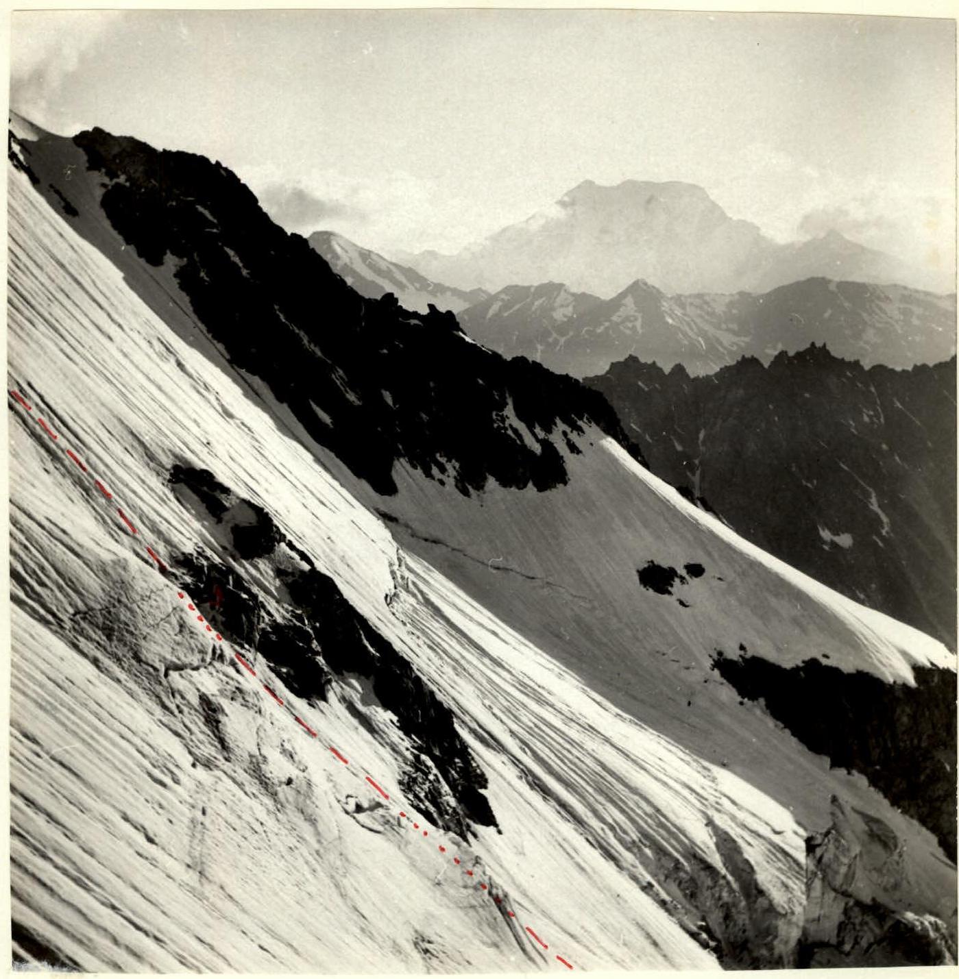
Lower Part of the North Wall of Peak Germogenova
Photographed on July 2, 1986, from the SW ridge of Chegetkara at 6:00 PM. Camera “Lubitel-166”, lens “LOMO T-22”, F = 75 mm. Ak – control tour.